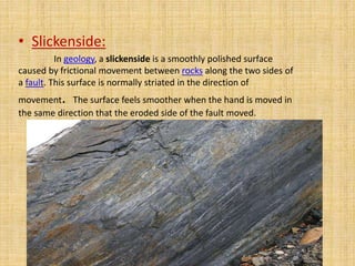
Structural Geology
What is Structural Geology? 
• Structural geology is the 
study of the three-dimensional 
distribution of rock units with 
respect to their deformational 
histories.
• The primary goal of structural geology is to use 
measurements of present-day rock geometries to 
uncover information about the history of 
deformation (strain) in the rocks, and ultimately, 
to understand the stress field that resulted in the 
observed strain and geometries. 
• This understanding of the dynamics of the stress 
field can be linked to important events in the 
regional geologic past.
Economical Importance of Structural Geology 
• The study of geologic structures has been of prime 
importance in economic geology. 
• Folded and faulted rock strata commonly form traps 
for the accumulation and concentration of fluids such 
as petroleum and natural gas. 
• Veins of minerals containing various metals 
commonly occupy faults and fractures in structurally 
complex areas. 
• Deposits of gold, silver, copper, lead, zinc, and other 
metals, are commonly located in structurally complex 
areas. 
• Structural geology is a critical part of engineering 
geology, which is concerned with the physical and 
mechanical properties of natural rocks.
Structural fabrics and defects 
• Folds 
• Joints 
• Faults 
• Foliations 
• These are internal weaknesses of rocks which 
may affect the stability of human engineered 
structures.
Deformation of Rocks 
• Within the Earth rocks are continually being 
subjected to forces that tend to bend them, twist 
them, or fracture them. When rocks bend, twist 
or fracture we say that they deform (change 
shape or size). 
• Deformation common 
at plate margins. 
• Deformation concepts… 
– Force 
– Stress 
– Strain
Stress 
• The forces that cause deformation of rock are 
referred to as stresses (Force/unit area). 
• Differential Stress – Unequal in different 
directions. 
• A uniform stress is a stress wherein the forces act 
equally from all directions. 
• 3 major types of differential stress 
– Compressional stress 
– Tensional stress 
– Shear stress
Compressional Stress 
• Push Together stress. 
• Shortens and thickens crust. 
• which squeezes rock.
Tensional Stress 
• “Pull-apart” stress. 
• Thins and stretches crust. 
• Associated with rifting
Shear Stress 
• Slippage of one rock mass past another. 
• In shallow crust, shear is often accommodated 
by bedding planes.
Strain 
• Changes in the shape or size of a rock body 
caused by stress. 
• Strain occurs when stresses exceed rock 
strength. 
• Strained rocks deform by folding, flowing, or 
fracturing
How Rocks Deforms 
• Elastic deformation – The rock returns to original 
size and shape when stress removed. 
• When the (strength) of a rock is surpassed, it 
either flows (ductile deformation) or fractures 
(brittle deformation). 
• Brittle behavior occurs in 
the shallow crust; ductile in 
the deeper crust.
We can divide materials into two 
classes. 
• Brittle materials have a small or large region of 
elastic behaviour but only a small region of 
ductile behaviour before they fracture. 
• Ductile materials have a small region of elastic 
behaviour and a large region of ductile 
behaviour before they fracture.
How a material behaves will depend 
on several factors 
• Temperature - At high temperature molecules and their bonds can stretch and 
move, thus materials will behave in more ductile manner. At low Temperature, 
materials are brittle. 
• Confining Pressure - At high confining pressure materials are less likely to 
fracture because the pressure of the surroundings tends to hinder the formation 
of fractures. At low confining stress, material will be brittle and tend to fracture 
sooner. 
• Strain rate -- At high strain rates material tends to fracture. At low strain rates 
more time is available for individual atoms to move and therefore ductile 
behaviour is favoured. 
• Composition -- Some minerals, like quartz, olivine, and feldspars are very 
brittle. Others, like clay minerals, micas, and calcite are more ductile This is due 
to the chemical bond types that hold them together. Thus, the mineralogical 
composition of the rock will be a factor in determining the deformational 
behaviour of the rock. Another aspect is presence or absence of water. Water 
appears to weaken the chemical bonds and forms films around mineral grains 
along which slippage can take place. Thus wet rock tends to behave in ductile 
manner, while dry rocks tend to behave in brittle manner.
Evidence of Former Deformation 
• Evidence of deformation that has occurred in the past 
is very evident in crustal rocks. 
• For example, sedimentary strata and lava flows 
generally follow the law of original horizontality. Thus, 
when we see such strata inclined instead of horizontal, 
evidence of an episode of deformation. 
• In order to uniquely define the orientation of a planar 
feature we first need to define two terms – 
– Strike (trend) 
– Dip (inclination)
Mapping Geologic Structures 
• Strike(trend) 
The compass direction of the line produced by the intersection of 
an inclined rock layer or fault with a horizontal plane. 
– Generally expressed as an angle relative to north. 
• N37°E 
• N12°W 
• Dip (inclination) 
The angle of inclination of the surface of a rock unit or fault measured 
from a horizontal plane. 
– Includes both an angle of inclination and a direction toward which the 
rock is inclined. 
• 82°SE 
• 17°SW
Mapping Geologic Structures 
• In recording strike and dip measurements on a geologic 
map, a symbol is used that has a long line oriented 
parallel to the compass direction of the strike. 
• A short tick mark is placed in the centres of the line on 
the side to which the inclined plane dips, and the angle 
of dip is recorded next to the strike and dip symbol as 
shown above. 
• For beds with a 900 dip (vertical) the short line crosses 
the strike line. 
• For beds with no dip (horizontal) a circle with a cross 
inside is used as shown below..
Joint 
• Any fracture, without any movement is called 
as joint. 
• When rock are under stress, and are at 
shallow depth then they may show brittle 
behavior and may get cracked. 
• Often rocks are cracked at their elastic limit, 
which may vary respect to their material 
properties.
• Joints can be classified into three groups depending on 
their geometrical relationship with the country rock: 
• Strike joints – Joints which run parallel to the direction of 
strike of country rocks are called "strike joints“. 
• Dip joints – Joints which run parallel to the direction of dip 
of country rocks are called "dip joints“. 
• Oblique joints – Joints which run oblique to the dip and 
strike directions of the country rocks are called "oblique 
joints".
Folds 
• Any bent or curved in a rock strata as a result of 
permanent deformation due to tectonic forces, is 
called as FOLD. 
• They occur singly as isolated folds and in 
extensive fold trains of different sizes, on a 
variety of scales. 
• A set of folds distributed on a regional scale 
constitutes a fold belt, a common feature of 
orogenic zones. 
• Folds are commonly formed by shortening of 
existing layers.
Faults 
• Fault is a planar fracture or discontinuity in a 
volume of rock, across which there has been 
significant displacement along the fractures as 
a result of earth movement. 
• Energy release associated with rapid 
movement on active faults is the cause of 
most earthquakes. 
• These earth quake may cause tremendous loss 
of life and property.
Faults
Faults 
• Faults occur when brittle rocks 
fracture and there is an offset along 
the fracture. 
• When the offset is small, the 
displacement can be easily measured, 
but sometimes the displacement is so 
large that it is difficult to measure.
Fault Terminology 
• A fault line is the surface trace of a fault, i-e the 
line of intersection between the fault plane. 
• A clearly seen line is formed by the intersection 
of faulted surfaces and can be observed even on 
satellite image. 
• Hanging wall: fault block above the fault plane is 
called as hanging wall. 
• Foot wall: fault block below the fault plane is 
called as foot wall.
• Fault blocks classified as 
Footwall (rock mass 
below the fault) 
Hanging wall 
(rock mass 
above the fault)
• Three dominant types 
– Normal fault 
– Reverse Fault 
– Thrust (a low angle reverse fault) 
– Strike Slip Fault
Normal fault 
– Hanging wall moves down relative to the footwall. 
– Accommodate lengthening or extension of the 
crust. 
– Exhibit a variety of scales
Normal Fault 
• Larger scale normal faults are associated with 
fault-block mountains (Basin and Range of 
Nevada). 
• Normal fault bounded valleys are called graben 
• Normal fault bounded ridges are called horsts. 
• Basin area has a series of horsts and grabens.
Reverse faults 
– Hanging wall block moves up relative 
to the footwall block 
– Reverse faults have dips greater than 45o 
– Accommodate shortening of the crust 
– Strong compressional forces
Thrust fault 
• A special case of reverse fault. 
– Hanging wall block moves up relative to the 
footwall block 
– Thrust faults are characterized by a low dip angle 
(less then 45o). 
– Accommodate shortening of the crust 
– Strong compressional forces
Strike-Slip Faults 
• Dominant displacement is horizontal 
and parallel to the strike of the fault 
• Types of strike-slip faults 
– Right-lateral – as you face the fault, the block on 
the opposite side of the fault moves to the right 
– Left-lateral – as you face the fault, the block on 
the opposite side of the fault moves to the left
Types of Strike Slip Fault
• Fault Splays: Fault is segments into 
many small faults. 
Sometimes, A big fault initiate many 
small other fault known as fault splays or 
implication.
Sierra Nevada mountains
Criteria to identify the faults 
Fault scarp 
• A fault scarp is the topographic expression of 
faulting attributed to the displacement of the 
land surface by movement along faults. 
• During faulting, one block may rise and appear 
as a raised ridge and shows steep bedding.
• Slickenside: 
In geology, a slickenside is a smoothly polished surface 
caused by frictional movement between rocks along the two sides of 
a fault. This surface is normally striated in the direction of 
movement. The surface feels smoother when the hand is moved in 
the same direction that the eroded side of the fault moved.
Mineralization 
• Friction along blocks of faults may cause 
dynamic metamorphism, fracturing and 
brecciation etc
Stream alignment: 
Offset streams are found along strike 
slip fault . If a stream is changing its path 
then it shows the presence of faults.
Raised ridges along coastal areas
Valleys: 
Valleys are of great importance because it is said that 
90 % of the valleys are being formed along the faults e.g 
Kaghan valley has alignment with Kunhar river and these 
streams are found along strike slip fault 
Kaghan Valley .
Hot water streams: 
Hot water streams highly 
suggests the presence of fault . 
Waterfalls: 
Water fall also suggests the 
presence of oblique faults.
Surface Geomorphology
IMPORTANCE OF STRUCTURAL 
GEOLOGY IN CIVIL ENGINEERING
What Structural Geologists Should do in 
Studying Structures? 
Map the geometry of structures accurately in the field 
and construct an accurate geologic map. 
Measure the orientation of small structures in the field to 
know the shapes and relative position of larger 
structures 
Study the sequence of development and superposition of 
different kinds of structures to determine the 
sequence condition of deformation. 
Try to apply rock-mechanics data to relate structures to 
stresses that present in the Earth at the times of 
deformation. 
Try to compare structures in one area with those else-where 
that may have formed by similar-mechanism. 
Utilize the geophysical data and other geology 
disciplines. Geophysical data such as gravity, 
magnetic, and seismic
IMPORTANCE OF STRUCTURAL GEOLOGY AND ITS 
RELATIONSHIP TO OTHER FIELDS 
• Engineering: Problems such as construction of 
bridges, dams, power plants, highways, and 
airports, and beneath buildings problems 
• Environmental: Problems such as land use, 
planning, earth quake hazard, volcanic hazard, 
waste isolation and disposal, control of the 
distribution of ground water 
• Petroleum and mining geology: Understanding 
the geometric techniques, projection of faults 
geologic contacts, larger trends of regional 
processes that control the concentration of 
mineral and hydrocarbons
Questions????????

Structural Geology

  • 1.
  • 2.
    What is StructuralGeology? • Structural geology is the study of the three-dimensional distribution of rock units with respect to their deformational histories.
  • 3.
    • The primarygoal of structural geology is to use measurements of present-day rock geometries to uncover information about the history of deformation (strain) in the rocks, and ultimately, to understand the stress field that resulted in the observed strain and geometries. • This understanding of the dynamics of the stress field can be linked to important events in the regional geologic past.
  • 4.
    Economical Importance ofStructural Geology • The study of geologic structures has been of prime importance in economic geology. • Folded and faulted rock strata commonly form traps for the accumulation and concentration of fluids such as petroleum and natural gas. • Veins of minerals containing various metals commonly occupy faults and fractures in structurally complex areas. • Deposits of gold, silver, copper, lead, zinc, and other metals, are commonly located in structurally complex areas. • Structural geology is a critical part of engineering geology, which is concerned with the physical and mechanical properties of natural rocks.
  • 5.
    Structural fabrics anddefects • Folds • Joints • Faults • Foliations • These are internal weaknesses of rocks which may affect the stability of human engineered structures.
  • 6.
    Deformation of Rocks • Within the Earth rocks are continually being subjected to forces that tend to bend them, twist them, or fracture them. When rocks bend, twist or fracture we say that they deform (change shape or size). • Deformation common at plate margins. • Deformation concepts… – Force – Stress – Strain
  • 7.
    Stress • Theforces that cause deformation of rock are referred to as stresses (Force/unit area). • Differential Stress – Unequal in different directions. • A uniform stress is a stress wherein the forces act equally from all directions. • 3 major types of differential stress – Compressional stress – Tensional stress – Shear stress
  • 8.
    Compressional Stress •Push Together stress. • Shortens and thickens crust. • which squeezes rock.
  • 9.
    Tensional Stress •“Pull-apart” stress. • Thins and stretches crust. • Associated with rifting
  • 10.
    Shear Stress •Slippage of one rock mass past another. • In shallow crust, shear is often accommodated by bedding planes.
  • 12.
    Strain • Changesin the shape or size of a rock body caused by stress. • Strain occurs when stresses exceed rock strength. • Strained rocks deform by folding, flowing, or fracturing
  • 13.
    How Rocks Deforms • Elastic deformation – The rock returns to original size and shape when stress removed. • When the (strength) of a rock is surpassed, it either flows (ductile deformation) or fractures (brittle deformation). • Brittle behavior occurs in the shallow crust; ductile in the deeper crust.
  • 14.
    We can dividematerials into two classes. • Brittle materials have a small or large region of elastic behaviour but only a small region of ductile behaviour before they fracture. • Ductile materials have a small region of elastic behaviour and a large region of ductile behaviour before they fracture.
  • 15.
    How a materialbehaves will depend on several factors • Temperature - At high temperature molecules and their bonds can stretch and move, thus materials will behave in more ductile manner. At low Temperature, materials are brittle. • Confining Pressure - At high confining pressure materials are less likely to fracture because the pressure of the surroundings tends to hinder the formation of fractures. At low confining stress, material will be brittle and tend to fracture sooner. • Strain rate -- At high strain rates material tends to fracture. At low strain rates more time is available for individual atoms to move and therefore ductile behaviour is favoured. • Composition -- Some minerals, like quartz, olivine, and feldspars are very brittle. Others, like clay minerals, micas, and calcite are more ductile This is due to the chemical bond types that hold them together. Thus, the mineralogical composition of the rock will be a factor in determining the deformational behaviour of the rock. Another aspect is presence or absence of water. Water appears to weaken the chemical bonds and forms films around mineral grains along which slippage can take place. Thus wet rock tends to behave in ductile manner, while dry rocks tend to behave in brittle manner.
  • 16.
    Evidence of FormerDeformation • Evidence of deformation that has occurred in the past is very evident in crustal rocks. • For example, sedimentary strata and lava flows generally follow the law of original horizontality. Thus, when we see such strata inclined instead of horizontal, evidence of an episode of deformation. • In order to uniquely define the orientation of a planar feature we first need to define two terms – – Strike (trend) – Dip (inclination)
  • 17.
    Mapping Geologic Structures • Strike(trend) The compass direction of the line produced by the intersection of an inclined rock layer or fault with a horizontal plane. – Generally expressed as an angle relative to north. • N37°E • N12°W • Dip (inclination) The angle of inclination of the surface of a rock unit or fault measured from a horizontal plane. – Includes both an angle of inclination and a direction toward which the rock is inclined. • 82°SE • 17°SW
  • 20.
    Mapping Geologic Structures • In recording strike and dip measurements on a geologic map, a symbol is used that has a long line oriented parallel to the compass direction of the strike. • A short tick mark is placed in the centres of the line on the side to which the inclined plane dips, and the angle of dip is recorded next to the strike and dip symbol as shown above. • For beds with a 900 dip (vertical) the short line crosses the strike line. • For beds with no dip (horizontal) a circle with a cross inside is used as shown below..
  • 23.
    Joint • Anyfracture, without any movement is called as joint. • When rock are under stress, and are at shallow depth then they may show brittle behavior and may get cracked. • Often rocks are cracked at their elastic limit, which may vary respect to their material properties.
  • 26.
    • Joints canbe classified into three groups depending on their geometrical relationship with the country rock: • Strike joints – Joints which run parallel to the direction of strike of country rocks are called "strike joints“. • Dip joints – Joints which run parallel to the direction of dip of country rocks are called "dip joints“. • Oblique joints – Joints which run oblique to the dip and strike directions of the country rocks are called "oblique joints".
  • 29.
    Folds • Anybent or curved in a rock strata as a result of permanent deformation due to tectonic forces, is called as FOLD. • They occur singly as isolated folds and in extensive fold trains of different sizes, on a variety of scales. • A set of folds distributed on a regional scale constitutes a fold belt, a common feature of orogenic zones. • Folds are commonly formed by shortening of existing layers.
  • 40.
    Faults • Faultis a planar fracture or discontinuity in a volume of rock, across which there has been significant displacement along the fractures as a result of earth movement. • Energy release associated with rapid movement on active faults is the cause of most earthquakes. • These earth quake may cause tremendous loss of life and property.
  • 41.
  • 42.
    Faults • Faultsoccur when brittle rocks fracture and there is an offset along the fracture. • When the offset is small, the displacement can be easily measured, but sometimes the displacement is so large that it is difficult to measure.
  • 43.
    Fault Terminology •A fault line is the surface trace of a fault, i-e the line of intersection between the fault plane. • A clearly seen line is formed by the intersection of faulted surfaces and can be observed even on satellite image. • Hanging wall: fault block above the fault plane is called as hanging wall. • Foot wall: fault block below the fault plane is called as foot wall.
  • 44.
    • Fault blocksclassified as Footwall (rock mass below the fault) Hanging wall (rock mass above the fault)
  • 45.
    • Three dominanttypes – Normal fault – Reverse Fault – Thrust (a low angle reverse fault) – Strike Slip Fault
  • 46.
    Normal fault –Hanging wall moves down relative to the footwall. – Accommodate lengthening or extension of the crust. – Exhibit a variety of scales
  • 47.
    Normal Fault •Larger scale normal faults are associated with fault-block mountains (Basin and Range of Nevada). • Normal fault bounded valleys are called graben • Normal fault bounded ridges are called horsts. • Basin area has a series of horsts and grabens.
  • 49.
    Reverse faults –Hanging wall block moves up relative to the footwall block – Reverse faults have dips greater than 45o – Accommodate shortening of the crust – Strong compressional forces
  • 50.
    Thrust fault •A special case of reverse fault. – Hanging wall block moves up relative to the footwall block – Thrust faults are characterized by a low dip angle (less then 45o). – Accommodate shortening of the crust – Strong compressional forces
  • 51.
    Strike-Slip Faults •Dominant displacement is horizontal and parallel to the strike of the fault • Types of strike-slip faults – Right-lateral – as you face the fault, the block on the opposite side of the fault moves to the right – Left-lateral – as you face the fault, the block on the opposite side of the fault moves to the left
  • 52.
    Types of StrikeSlip Fault
  • 53.
    • Fault Splays:Fault is segments into many small faults. Sometimes, A big fault initiate many small other fault known as fault splays or implication.
  • 55.
  • 56.
    Criteria to identifythe faults Fault scarp • A fault scarp is the topographic expression of faulting attributed to the displacement of the land surface by movement along faults. • During faulting, one block may rise and appear as a raised ridge and shows steep bedding.
  • 60.
    • Slickenside: Ingeology, a slickenside is a smoothly polished surface caused by frictional movement between rocks along the two sides of a fault. This surface is normally striated in the direction of movement. The surface feels smoother when the hand is moved in the same direction that the eroded side of the fault moved.
  • 62.
    Mineralization • Frictionalong blocks of faults may cause dynamic metamorphism, fracturing and brecciation etc
  • 66.
    Stream alignment: Offsetstreams are found along strike slip fault . If a stream is changing its path then it shows the presence of faults.
  • 69.
    Raised ridges alongcoastal areas
  • 70.
    Valleys: Valleys areof great importance because it is said that 90 % of the valleys are being formed along the faults e.g Kaghan valley has alignment with Kunhar river and these streams are found along strike slip fault Kaghan Valley .
  • 71.
    Hot water streams: Hot water streams highly suggests the presence of fault . Waterfalls: Water fall also suggests the presence of oblique faults.
  • 73.
  • 75.
    IMPORTANCE OF STRUCTURAL GEOLOGY IN CIVIL ENGINEERING
  • 76.
    What Structural GeologistsShould do in Studying Structures? Map the geometry of structures accurately in the field and construct an accurate geologic map. Measure the orientation of small structures in the field to know the shapes and relative position of larger structures Study the sequence of development and superposition of different kinds of structures to determine the sequence condition of deformation. Try to apply rock-mechanics data to relate structures to stresses that present in the Earth at the times of deformation. Try to compare structures in one area with those else-where that may have formed by similar-mechanism. Utilize the geophysical data and other geology disciplines. Geophysical data such as gravity, magnetic, and seismic
  • 77.
    IMPORTANCE OF STRUCTURALGEOLOGY AND ITS RELATIONSHIP TO OTHER FIELDS • Engineering: Problems such as construction of bridges, dams, power plants, highways, and airports, and beneath buildings problems • Environmental: Problems such as land use, planning, earth quake hazard, volcanic hazard, waste isolation and disposal, control of the distribution of ground water • Petroleum and mining geology: Understanding the geometric techniques, projection of faults geologic contacts, larger trends of regional processes that control the concentration of mineral and hydrocarbons
  • 78.