Crustal Deformation &Mountain Building
Crustal Deformation & Mountain Building
• The process of forming a
The process of forming a
mountain not only uplifts the
mountain not only uplifts the
surface of the Earth, it causes
surface of the Earth, it causes
rocks to undergo
rocks to undergo Deformation.
Deformation.
• Deformation:
Deformation: The process by
The process by
which rocks are deformed
which rocks are deformed
(squashed, stretched, sheared,
(squashed, stretched, sheared,
etc…) in response to squeezing,
etc…) in response to squeezing,
stretching, shearing etc (i.e.
stretching, shearing etc (i.e.
differential stress).
differential stress).
• Deformation produces a variety
Deformation produces a variety
of geologic structures including
of geologic structures including
– Joints
Joints
– Faults
Faults
– Folds
Folds
– Foliation
Foliation
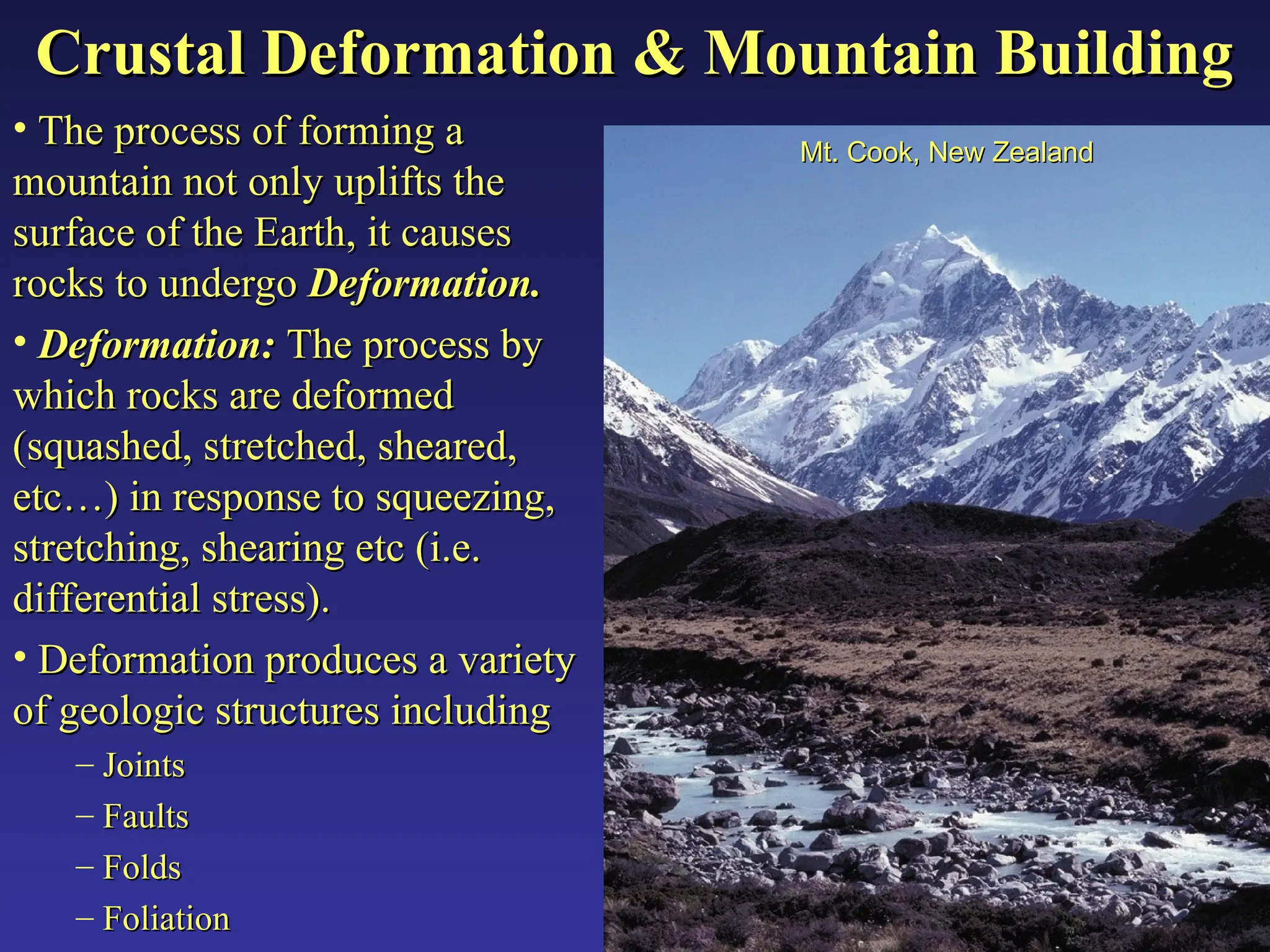
Mt. Cook, New Zealand
Mt. Cook, New Zealand
2.
Mountain Belts andOrogens
Mountain Belts and Orogens
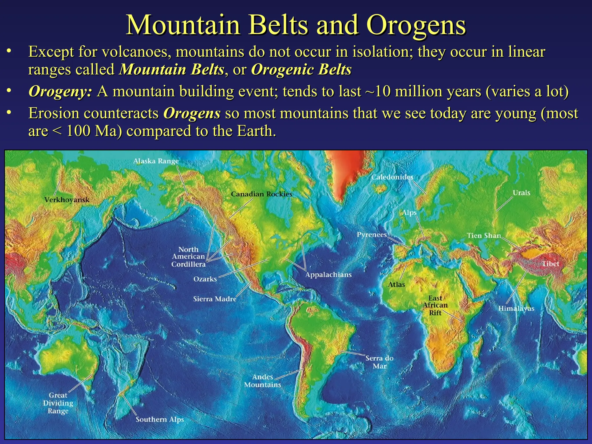
• Except for volcanoes, mountains do not occur in isolation; they occur in linear
Except for volcanoes, mountains do not occur in isolation; they occur in linear
ranges called
ranges called Mountain Belts
Mountain Belts, or
, or Orogenic Belts
Orogenic Belts
• Orogeny:
Orogeny: A mountain building event; tends to last ~10 million years (varies a lot)
A mountain building event; tends to last ~10 million years (varies a lot)
• Erosion counteracts
Erosion counteracts Orogens
Orogens so most mountains that we see today are young (most
so most mountains that we see today are young (most
are < 100 Ma) compared to the Earth.
are < 100 Ma) compared to the Earth.
3.
Deformed vs. Undeformed
Deformedvs. Undeformed
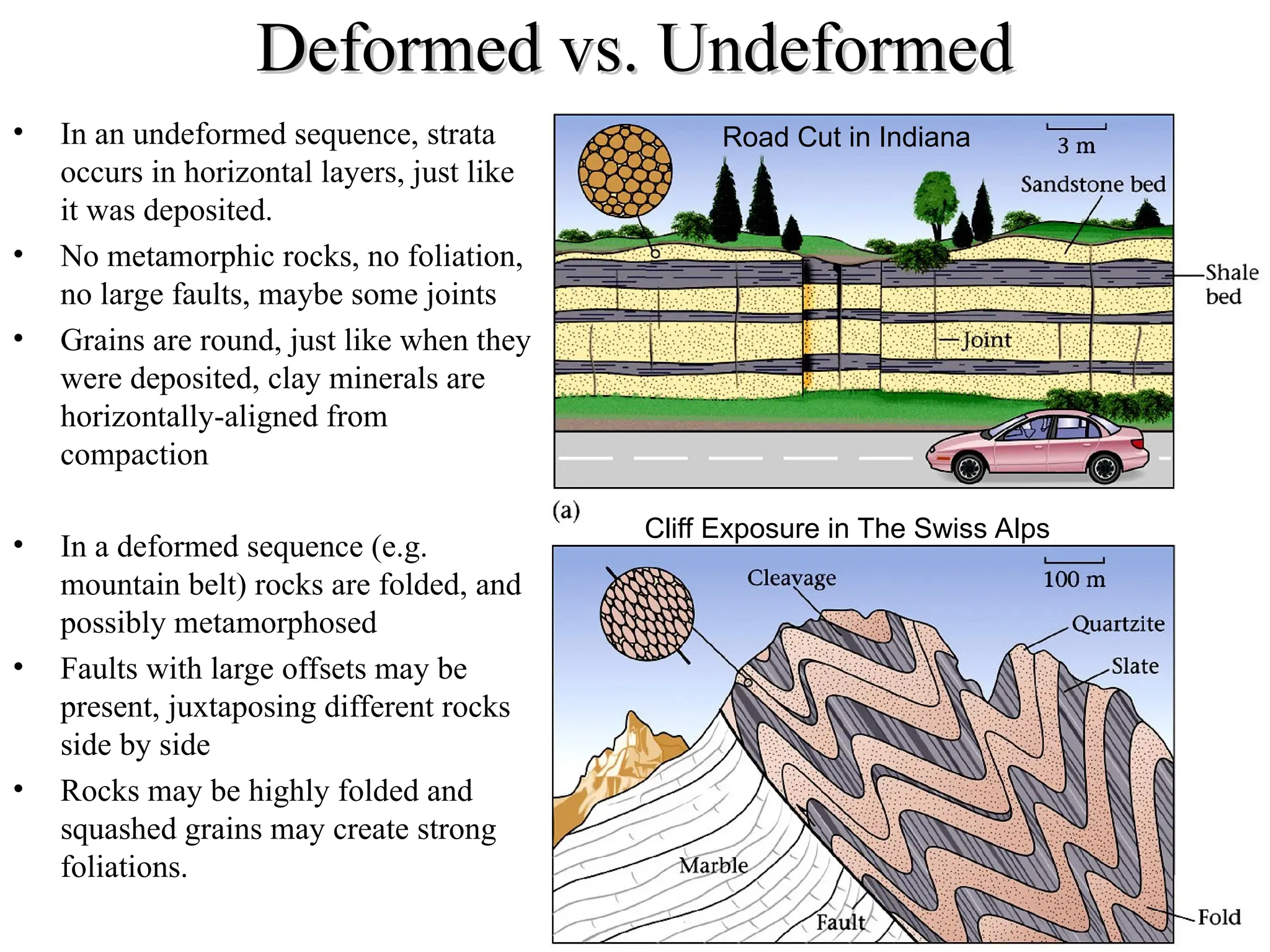
• In an undeformed sequence, strata
occurs in horizontal layers, just like
it was deposited.
• No metamorphic rocks, no foliation,
no large faults, maybe some joints
• Grains are round, just like when they
were deposited, clay minerals are
horizontally-aligned from
compaction
• In a deformed sequence (e.g.
mountain belt) rocks are folded, and
possibly metamorphosed
• Faults with large offsets may be
present, juxtaposing different rocks
side by side
• Rocks may be highly folded and
squashed grains may create strong
foliations.
Road Cut in Indiana
Cliff Exposure in The Swiss Alps
4.
Deformation
Deformation
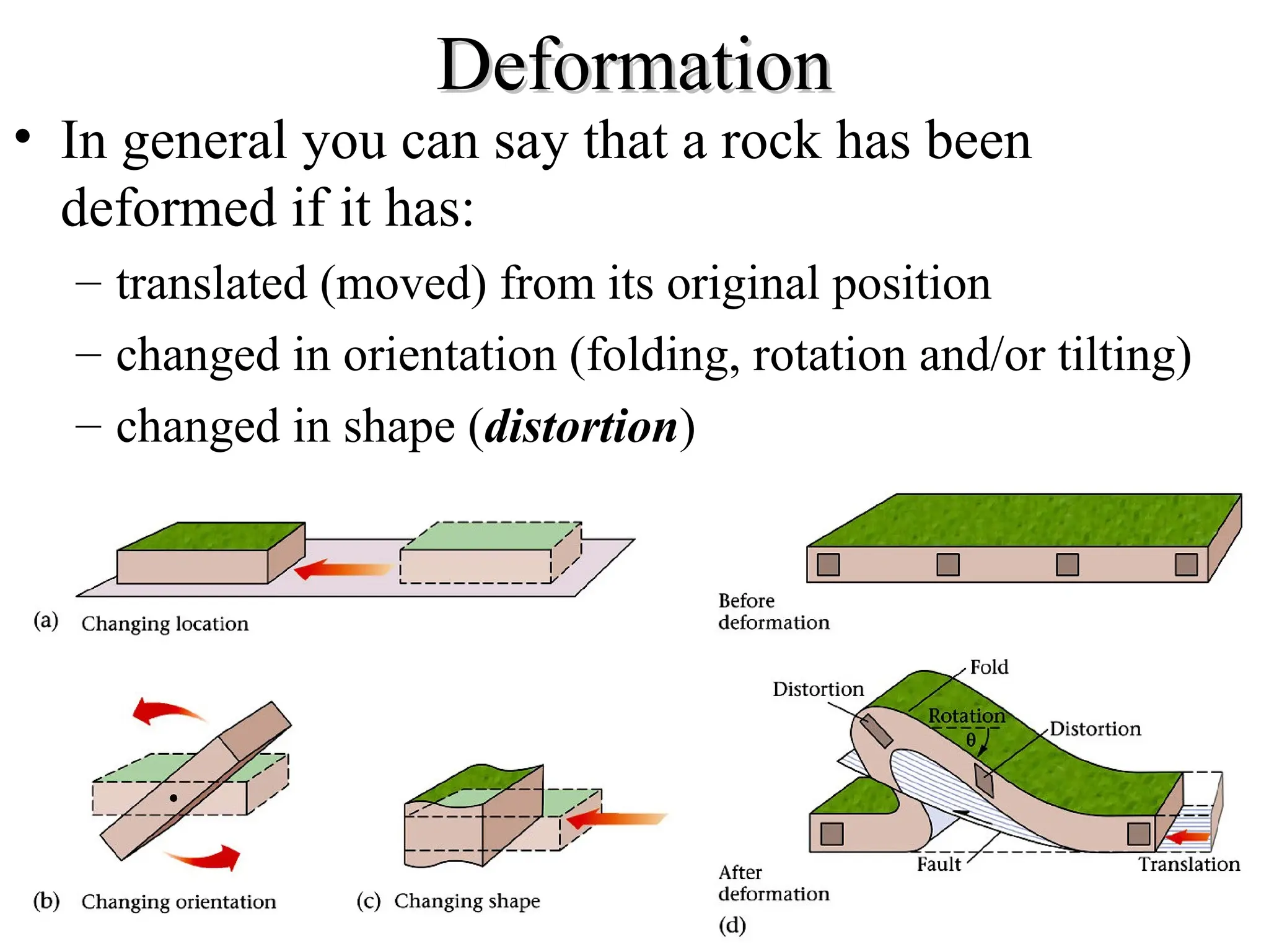
• In generalyou can say that a rock has been
deformed if it has:
– translated (moved) from its original position
– changed in orientation (folding, rotation and/or tilting)
– changed in shape (distortion)
5.
Types of Strain
Typesof Strain
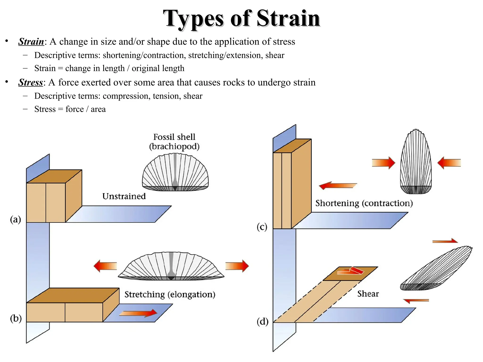
• Strain: A change in size and/or shape due to the application of stress
– Descriptive terms: shortening/contraction, stretching/extension, shear
– Strain = change in length / original length
• Stress: A force exerted over some area that causes rocks to undergo strain
– Descriptive terms: compression, tension, shear
– Stress = force / area
6.
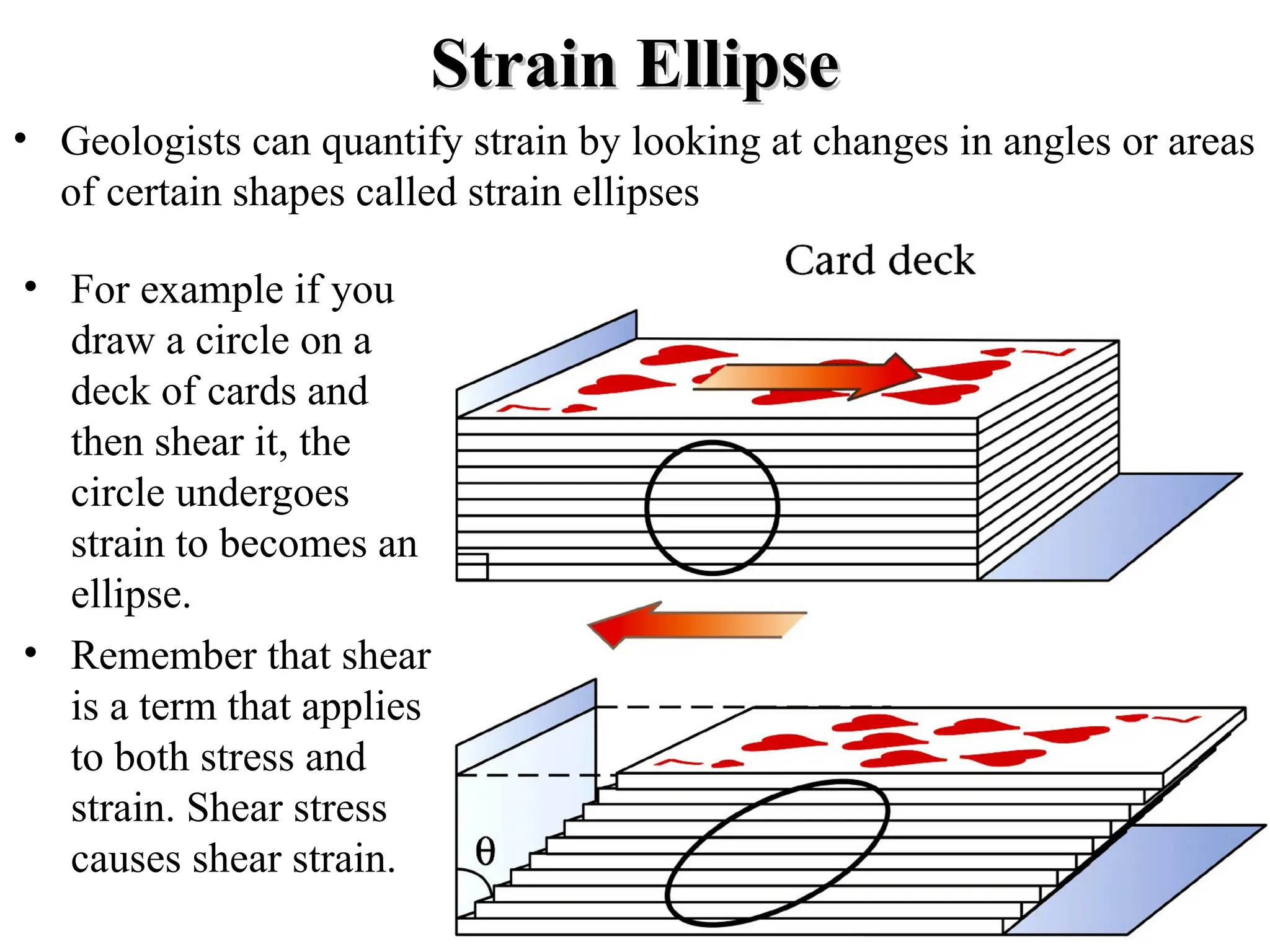
Strain Ellipse
Strain Ellipse
•Geologists can quantify strain by looking at changes in angles or areas
of certain shapes called strain ellipses
• For example if you
draw a circle on a
deck of cards and
then shear it, the
circle undergoes
strain to becomes an
ellipse.
• Remember that shear
is a term that applies
to both stress and
strain. Shear stress
causes shear strain.
7.
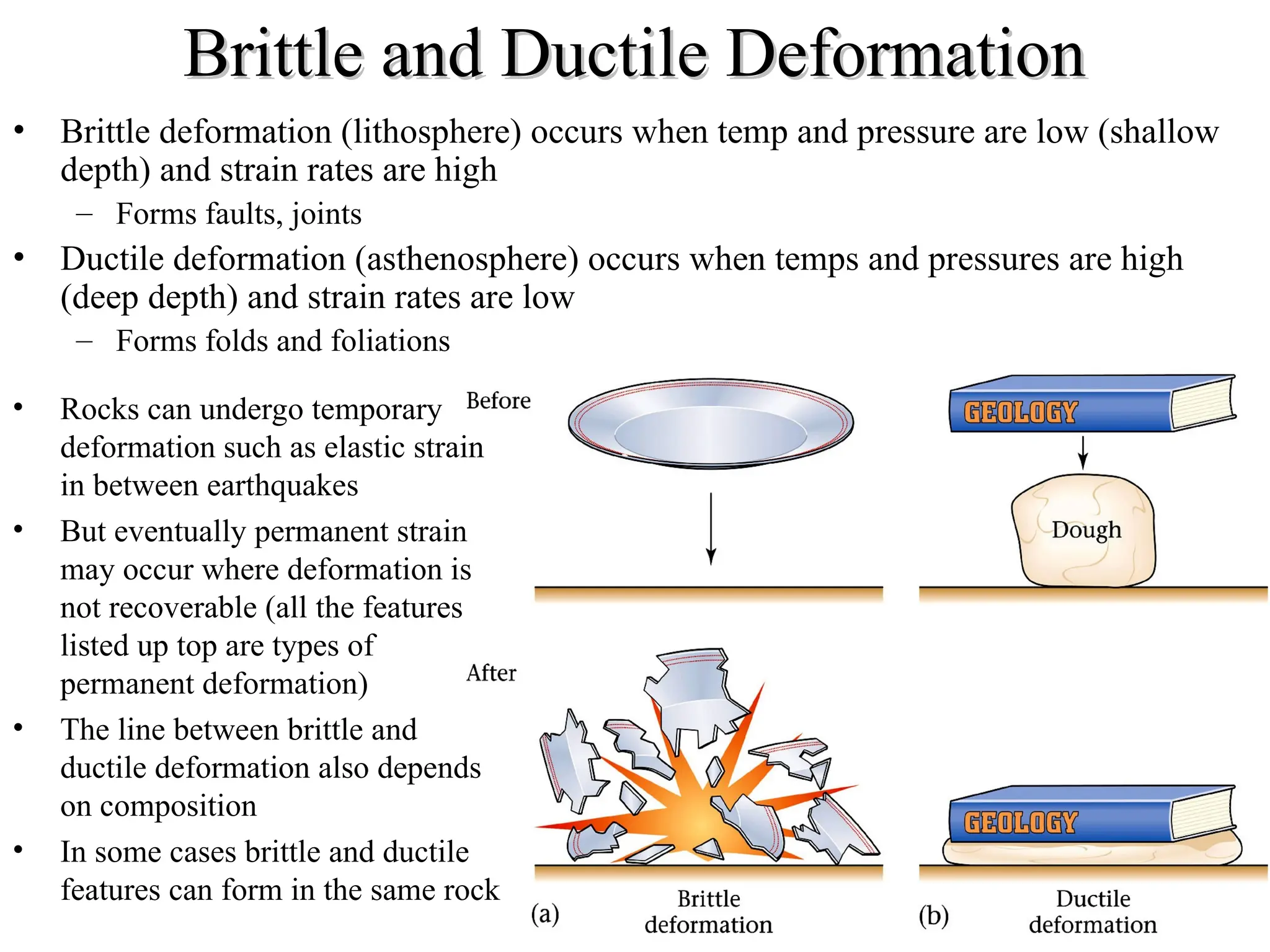
Brittle and DuctileDeformation
Brittle and Ductile Deformation
• Brittle deformation (lithosphere) occurs when temp and pressure are low (shallow
depth) and strain rates are high
– Forms faults, joints
• Ductile deformation (asthenosphere) occurs when temps and pressures are high
(deep depth) and strain rates are low
– Forms folds and foliations
• Rocks can undergo temporary
deformation such as elastic strain
in between earthquakes
• But eventually permanent strain
may occur where deformation is
not recoverable (all the features
listed up top are types of
permanent deformation)
• The line between brittle and
ductile deformation also depends
on composition
• In some cases brittle and ductile
features can form in the same rock
8.
Stress
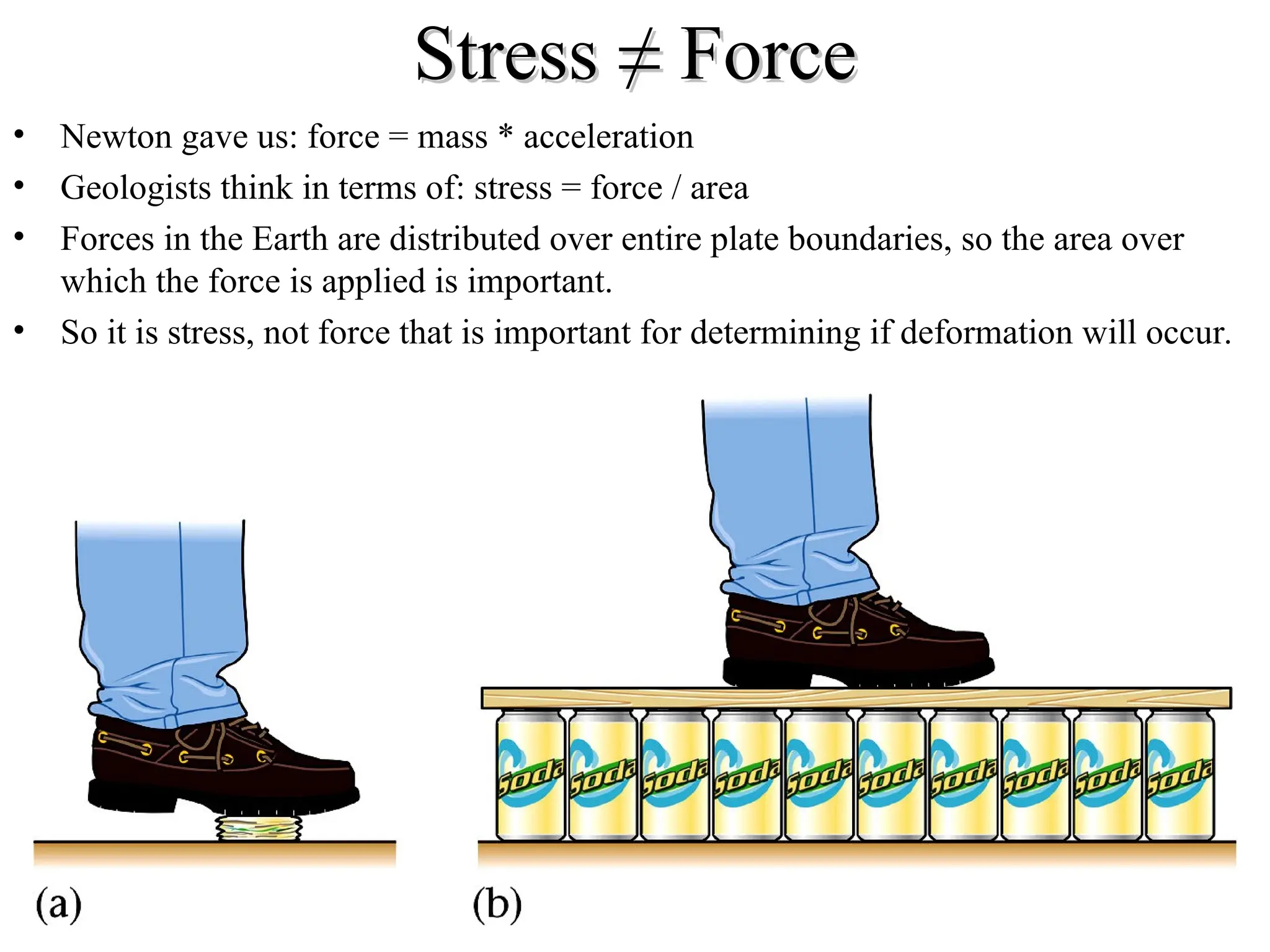
Stress ≠ Force
≠Force
• Newton gave us: force = mass * acceleration
• Geologists think in terms of: stress = force / area
• Forces in the Earth are distributed over entire plate boundaries, so the area over
which the force is applied is important.
• So it is stress, not force that is important for determining if deformation will occur.
9.
Types of Stress
Typesof Stress
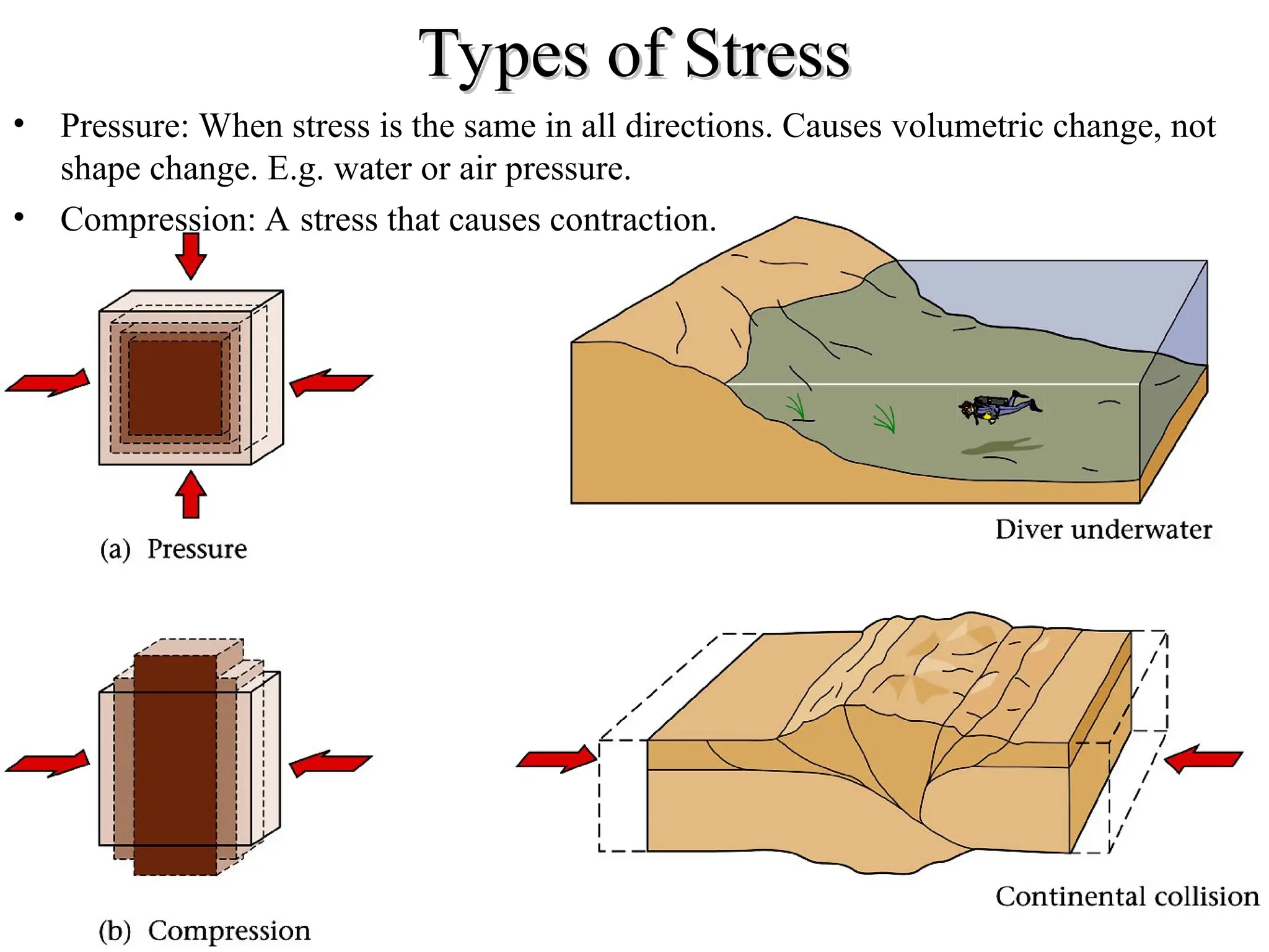
• Pressure: When stress is the same in all directions. Causes volumetric change, not
shape change. E.g. water or air pressure.
• Compression: A stress that causes contraction.
10.
Types of Stress
Typesof Stress
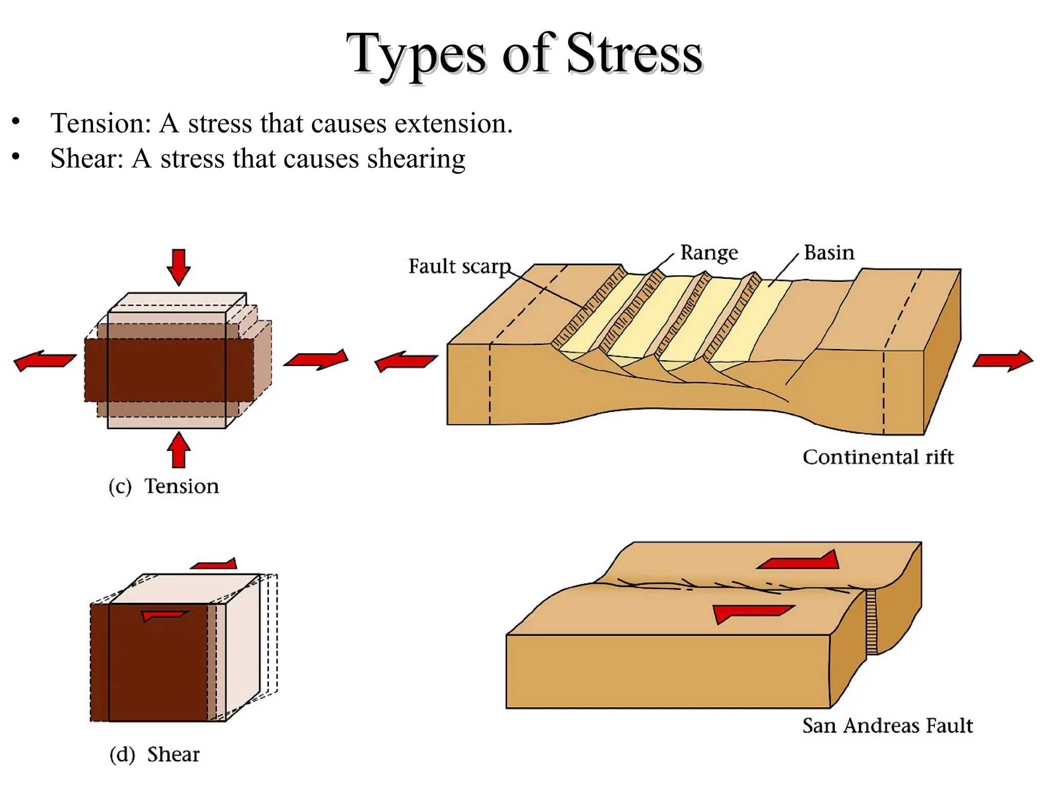
• Tension: A stress that causes extension.
• Shear: A stress that causes shearing
11.
Measuring Orientation: Strikeand Dip
Measuring Orientation: Strike and Dip
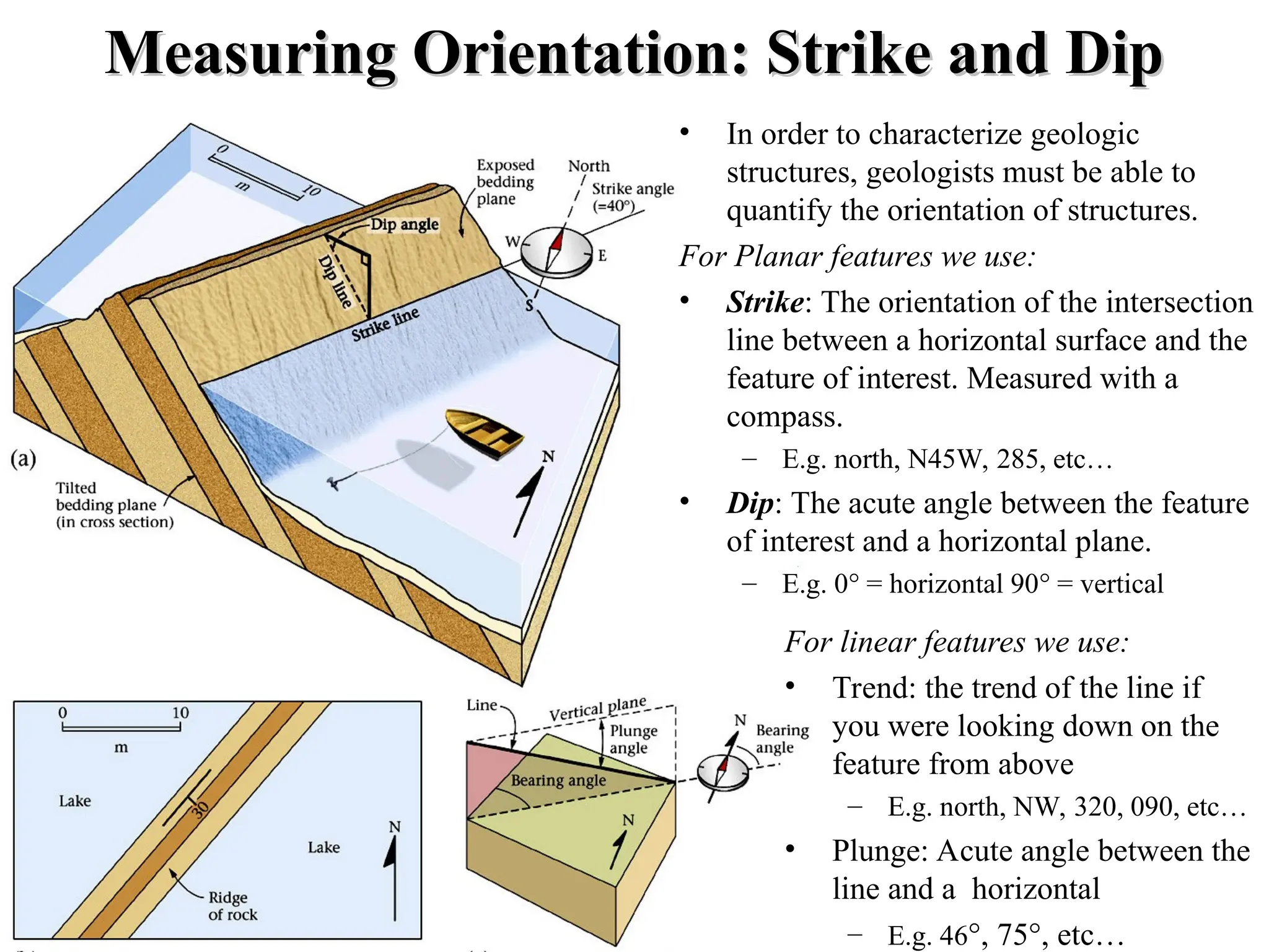
• In order to characterize geologic
structures, geologists must be able to
quantify the orientation of structures.
For Planar features we use:
• Strike: The orientation of the intersection
line between a horizontal surface and the
feature of interest. Measured with a
compass.
– E.g. north, N45W, 285, etc…
• Dip: The acute angle between the feature
of interest and a horizontal plane.
– E.g. 0° = horizontal 90° = vertical
For linear features we use:
• Trend: the trend of the line if
you were looking down on the
feature from above
– E.g. north, NW, 320, 090, etc…
• Plunge: Acute angle between the
line and a horizontal
– E.g. 46°, 75°, etc…
12.
Joints
Joints
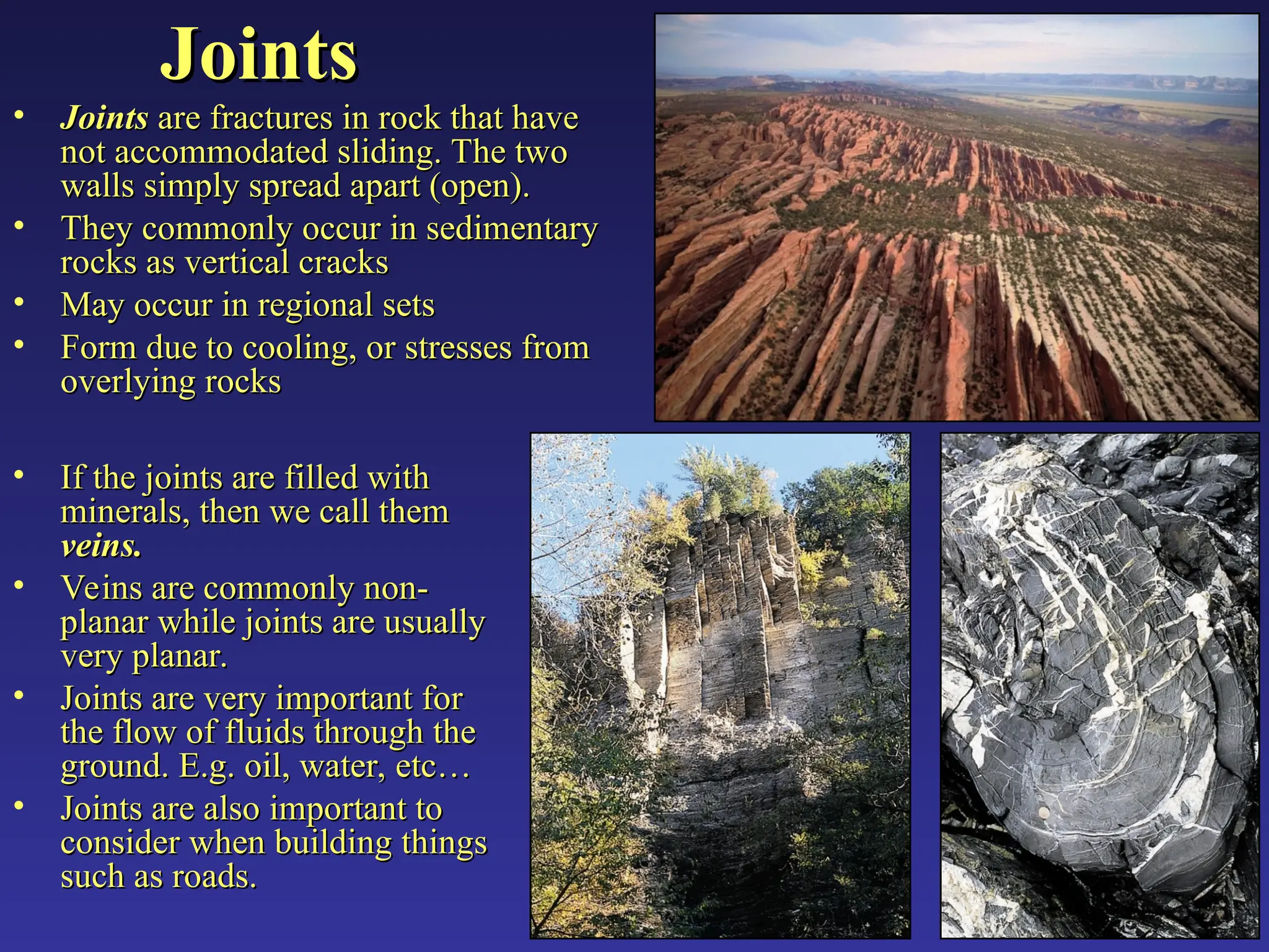
• Joints
Joints arefractures in rock that have
are fractures in rock that have
not accommodated sliding. The two
not accommodated sliding. The two
walls simply spread apart (open).
walls simply spread apart (open).
• They commonly occur in sedimentary
They commonly occur in sedimentary
rocks as vertical cracks
rocks as vertical cracks
• May occur in regional sets
May occur in regional sets
• Form due to cooling, or stresses from
Form due to cooling, or stresses from
overlying rocks
overlying rocks
• If the joints are filled with
If the joints are filled with
minerals, then we call them
minerals, then we call them
veins.
veins.
• Veins are commonly non-
Veins are commonly non-
planar while joints are usually
planar while joints are usually
very planar.
very planar.
• Joints are very important for
Joints are very important for
the flow of fluids through the
the flow of fluids through the
ground. E.g. oil, water, etc…
ground. E.g. oil, water, etc…
• Joints are also important to
Joints are also important to
consider when building things
consider when building things
such as roads.
such as roads.
13.
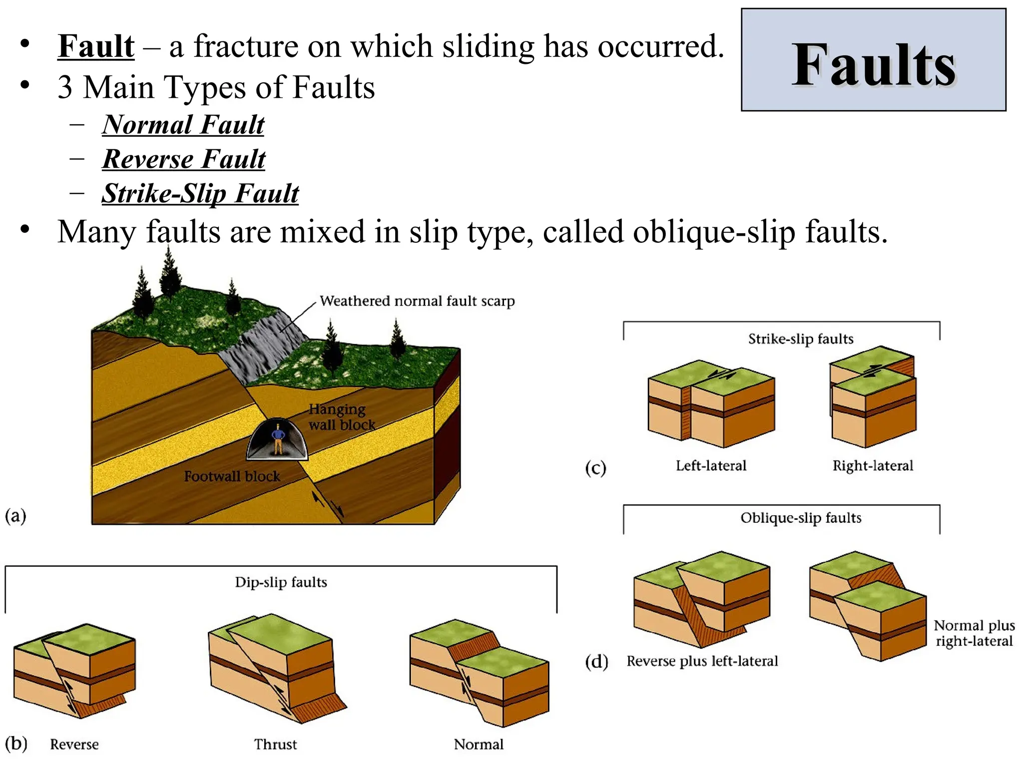
Faults
Faults
• Fault –a fracture on which sliding has occurred.
• 3 Main Types of Faults
– Normal Fault
– Reverse Fault
– Strike-Slip Fault
• Many faults are mixed in slip type, called oblique-slip faults.
14.
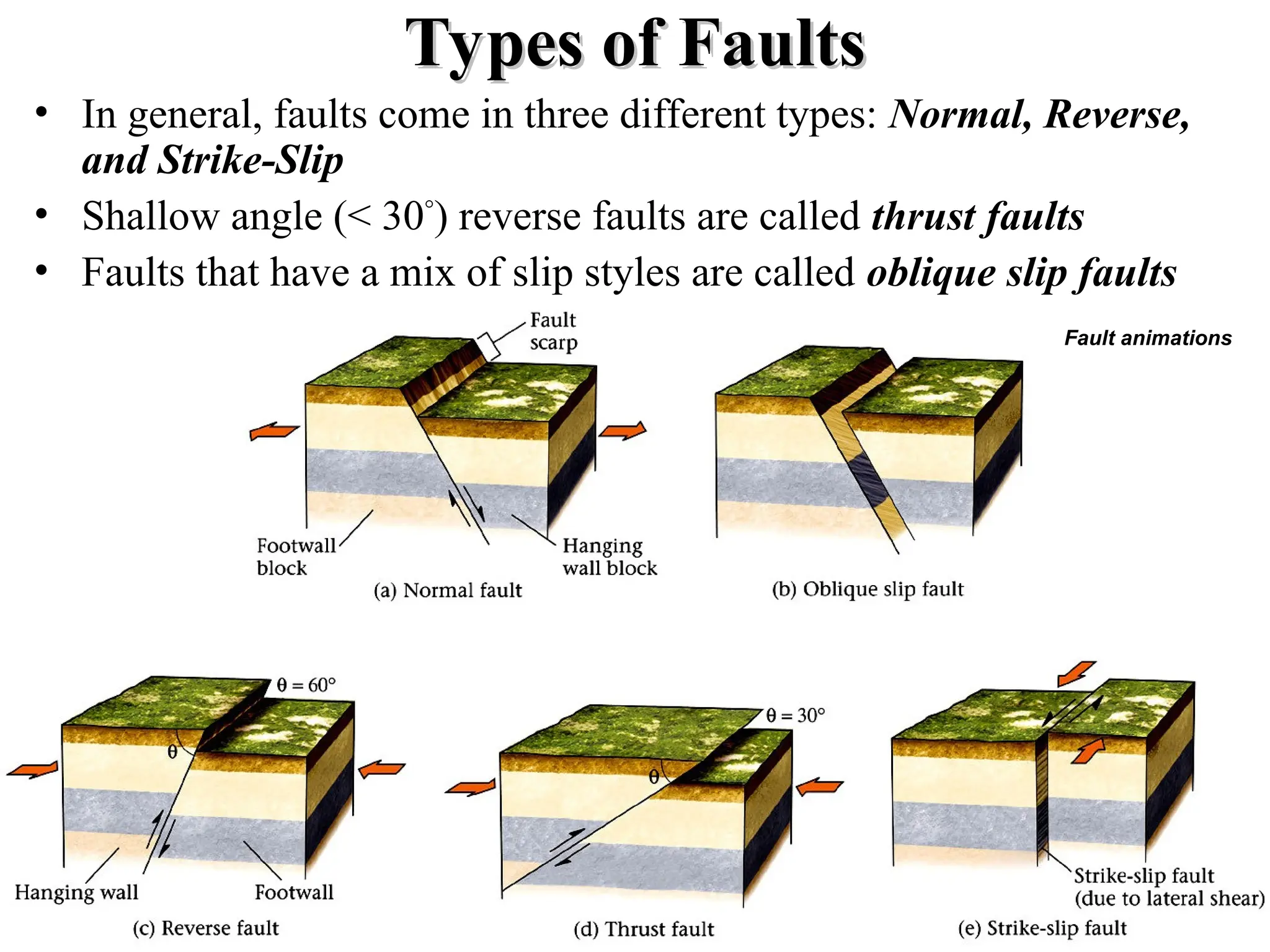
Types of Faults
Typesof Faults
• In general, faults come in three different types: Normal, Reverse,
and Strike-Slip
• Shallow angle (< 30°
) reverse faults are called thrust faults
• Faults that have a mix of slip styles are called oblique slip faults
Fault animations
15.
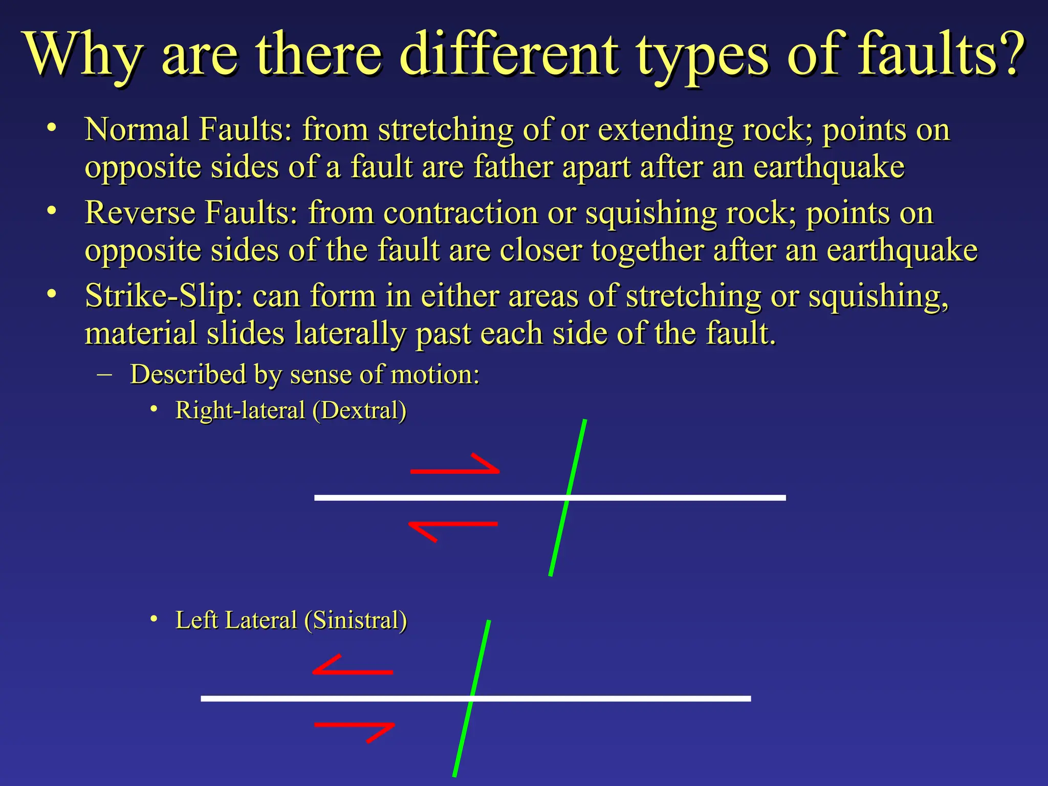
• Normal Faults:from stretching of or extending rock; points on
Normal Faults: from stretching of or extending rock; points on
opposite sides of a fault are father apart after an earthquake
opposite sides of a fault are father apart after an earthquake
• Reverse Faults: from contraction or squishing rock; points on
Reverse Faults: from contraction or squishing rock; points on
opposite sides of the fault are closer together after an earthquake
opposite sides of the fault are closer together after an earthquake
• Strike-Slip: can form in either areas of stretching or squishing,
Strike-Slip: can form in either areas of stretching or squishing,
material slides laterally past each side of the fault.
material slides laterally past each side of the fault.
– Described by sense of motion:
Described by sense of motion:
• Right-lateral (Dextral)
Right-lateral (Dextral)
• Left Lateral (Sinistral)
Left Lateral (Sinistral)
Why are there different types of faults?
Why are there different types of faults?
16.
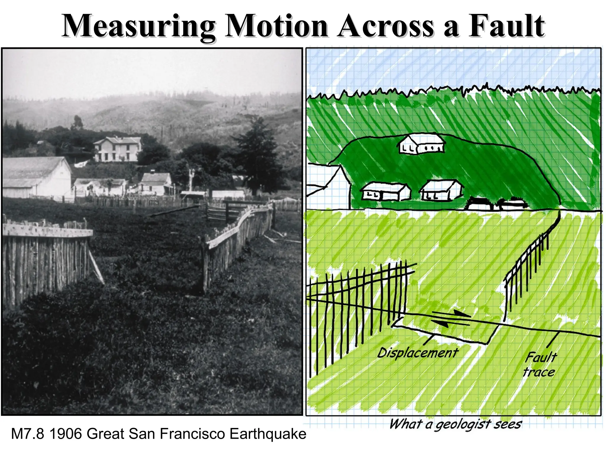
Measuring Motion Acrossa Fault
Measuring Motion Across a Fault
M7.8 1906 Great San Francisco Earthquake
17.
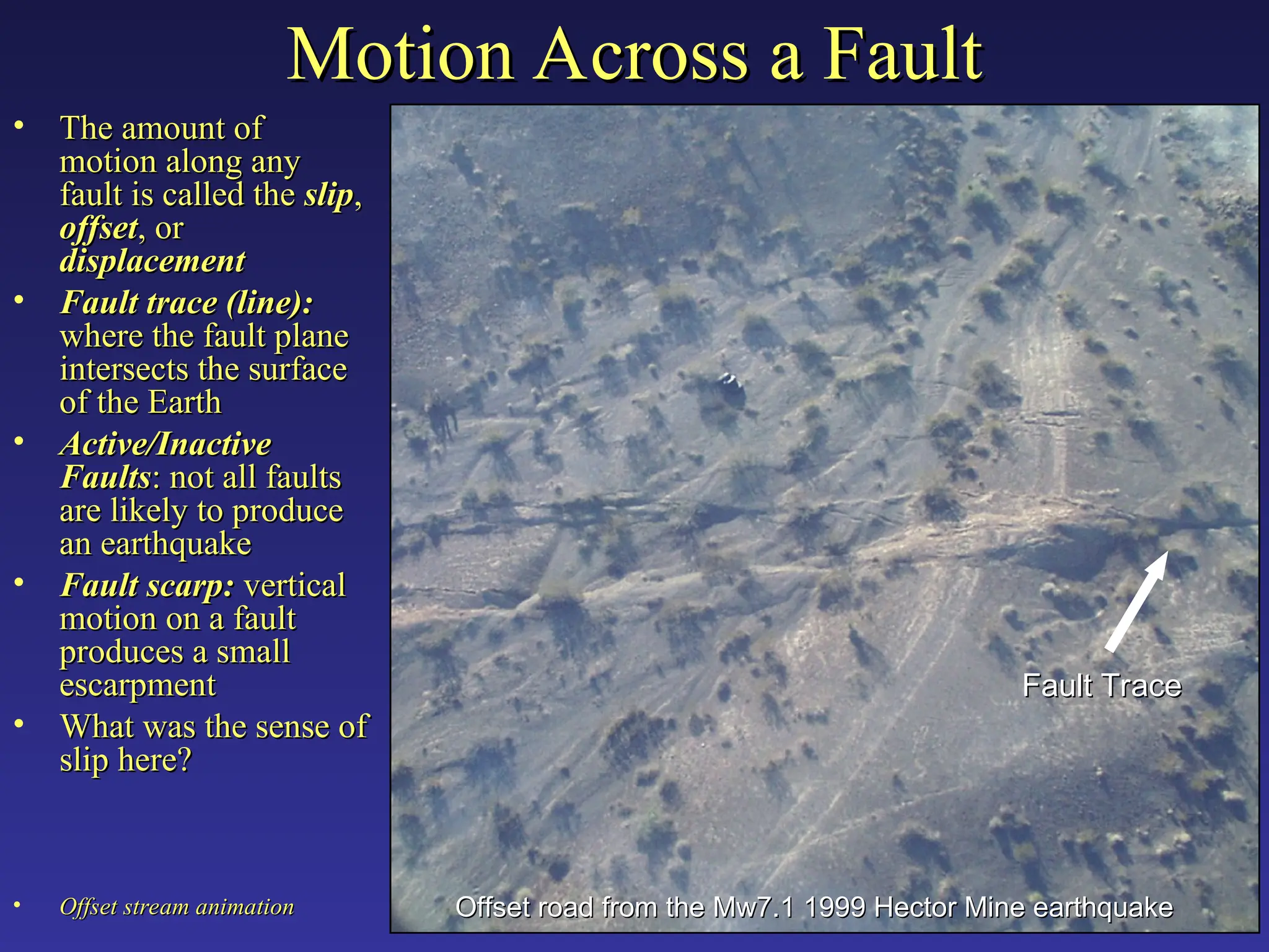
Motion Across aFault
Motion Across a Fault
• The amount of
The amount of
motion along any
motion along any
fault is called the
fault is called the slip
slip,
,
offset
offset, or
, or
displacement
displacement
• Fault trace (line):
Fault trace (line):
where the fault plane
where the fault plane
intersects the surface
intersects the surface
of the Earth
of the Earth
• Active/Inactive
Active/Inactive
Faults
Faults: not all faults
: not all faults
are likely to produce
are likely to produce
an earthquake
an earthquake
• Fault scarp:
Fault scarp: vertical
vertical
motion on a fault
motion on a fault
produces a small
produces a small
escarpment
escarpment
• What was the sense of
What was the sense of
slip here?
slip here?
• Offset stream animation
Offset stream animation
Fault Trace
Fault Trace
Offset road from the Mw7.1 1999 Hector Mine earthquake
Offset road from the Mw7.1 1999 Hector Mine earthquake
18.
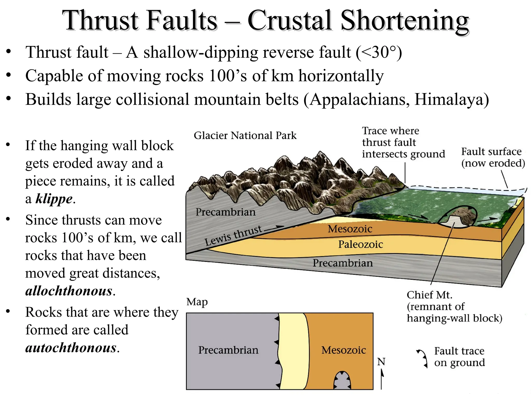
Thrust Faults –Crustal Shortening
Thrust Faults – Crustal Shortening
• Thrust fault – A shallow-dipping reverse fault (<30°)
• Capable of moving rocks 100’s of km horizontally
• Builds large collisional mountain belts (Appalachians, Himalaya)
• If the hanging wall block
gets eroded away and a
piece remains, it is called
a klippe.
• Since thrusts can move
rocks 100’s of km, we call
rocks that have been
moved great distances,
allochthonous.
• Rocks that are where they
formed are called
autochthonous.
19.
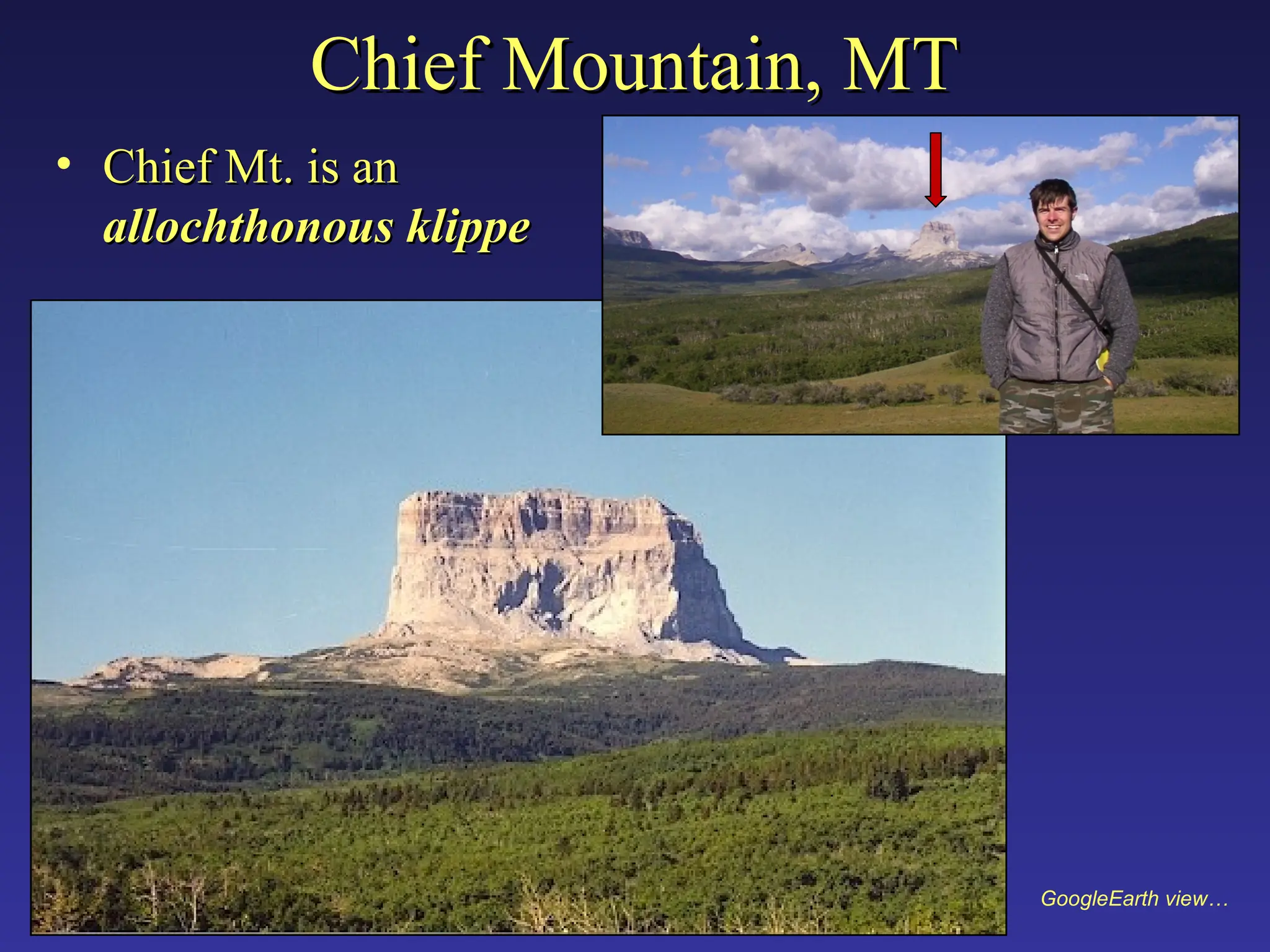
Chief Mountain, MT
ChiefMountain, MT
• Chief Mt. is an
Chief Mt. is an
allochthonous klippe
allochthonous klippe
GoogleEarth view…
20.
Normal Faults –Crustal Extension
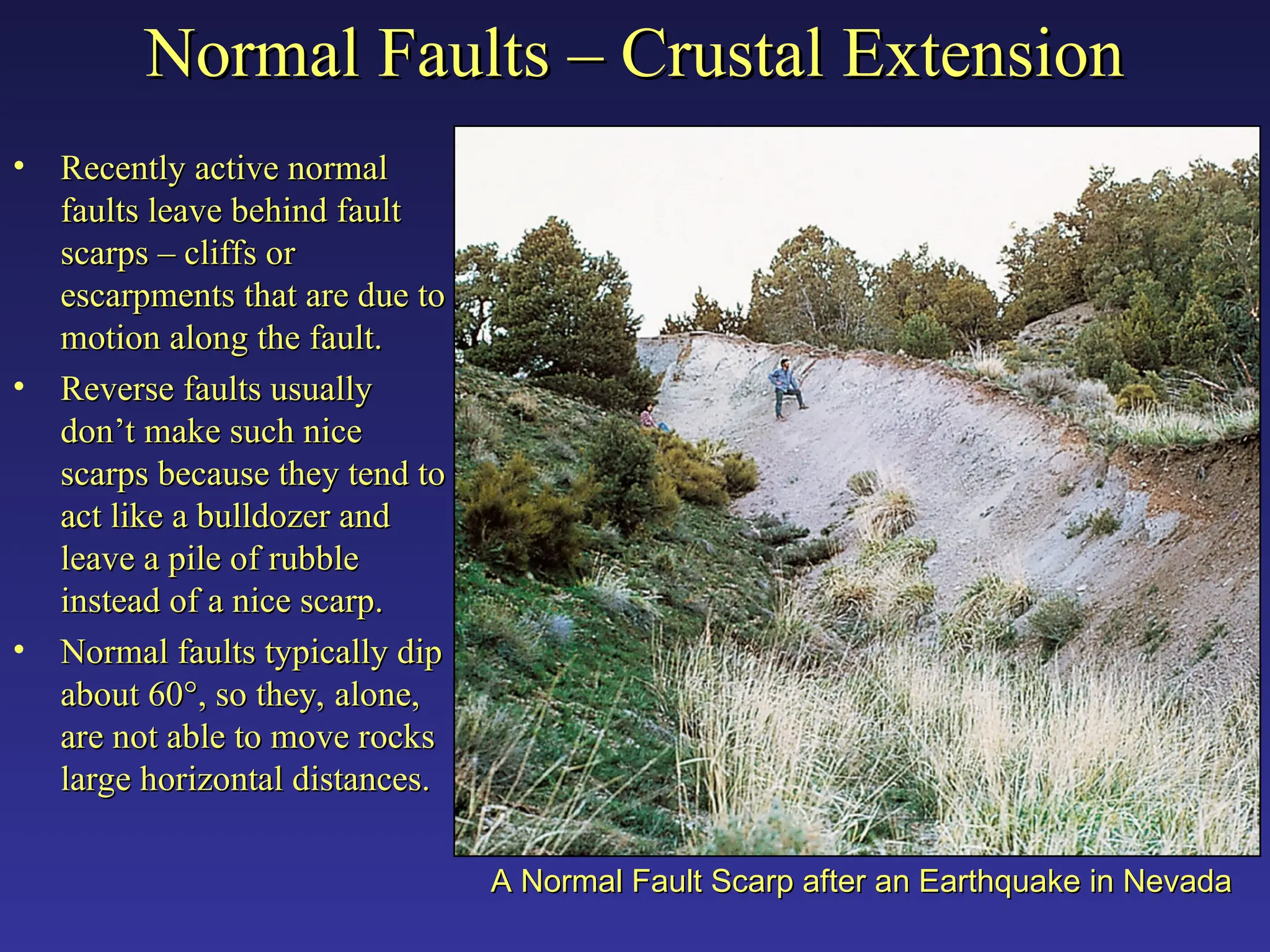
Normal Faults – Crustal Extension
• Recently active normal
Recently active normal
faults leave behind fault
faults leave behind fault
scarps – cliffs or
scarps – cliffs or
escarpments that are due to
escarpments that are due to
motion along the fault.
motion along the fault.
• Reverse faults usually
Reverse faults usually
don’t make such nice
don’t make such nice
scarps because they tend to
scarps because they tend to
act like a bulldozer and
act like a bulldozer and
leave a pile of rubble
leave a pile of rubble
instead of a nice scarp.
instead of a nice scarp.
• Normal faults typically dip
Normal faults typically dip
about 60
about 60°
°, so they, alone,
, so they, alone,
are not able to move rocks
are not able to move rocks
large horizontal distances.
large horizontal distances.
A Normal Fault Scarp after an Earthquake in Nevada
A Normal Fault Scarp after an Earthquake in Nevada
21.
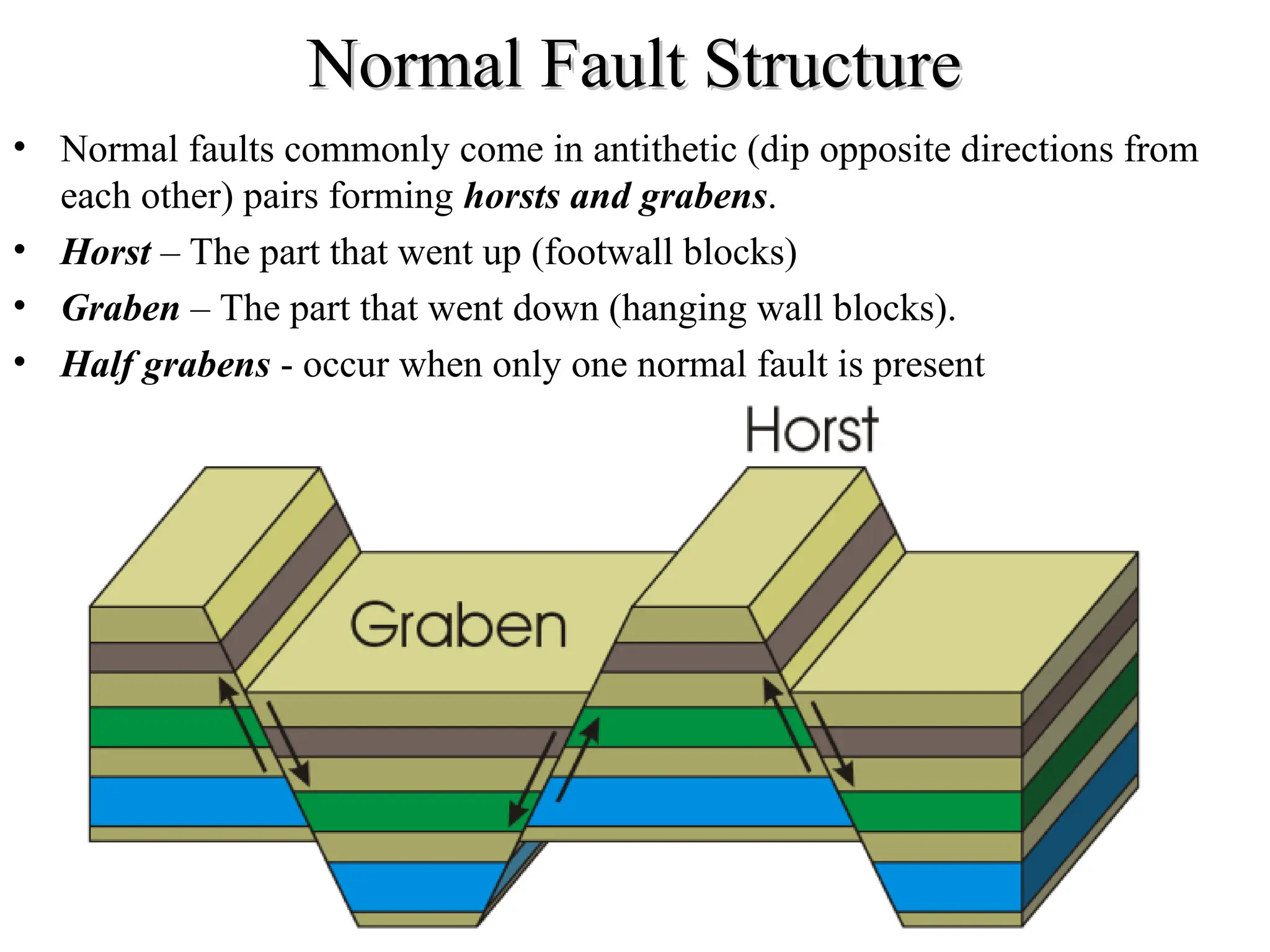
Normal Fault Structure
NormalFault Structure
• Normal faults commonly come in antithetic (dip opposite directions from
each other) pairs forming horsts and grabens.
• Horst – The part that went up (footwall blocks)
• Graben – The part that went down (hanging wall blocks).
• Half grabens - occur when only one normal fault is present
22.
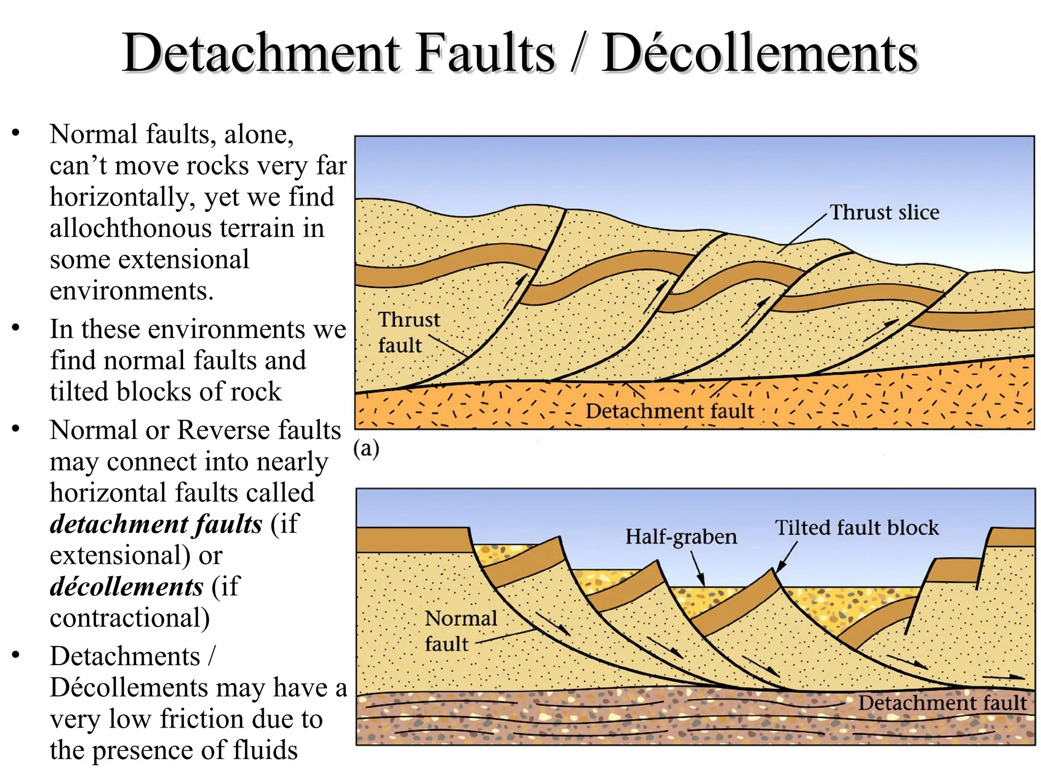
Detachment Faults /Décollements
Detachment Faults / Décollements
• Normal faults, alone,
can’t move rocks very far
horizontally, yet we find
allochthonous terrain in
some extensional
environments.
• In these environments we
find normal faults and
tilted blocks of rock
• Normal or Reverse faults
may connect into nearly
horizontal faults called
detachment faults (if
extensional) or
décollements (if
contractional)
• Detachments /
Décollements may have a
very low friction due to
the presence of fluids
23.
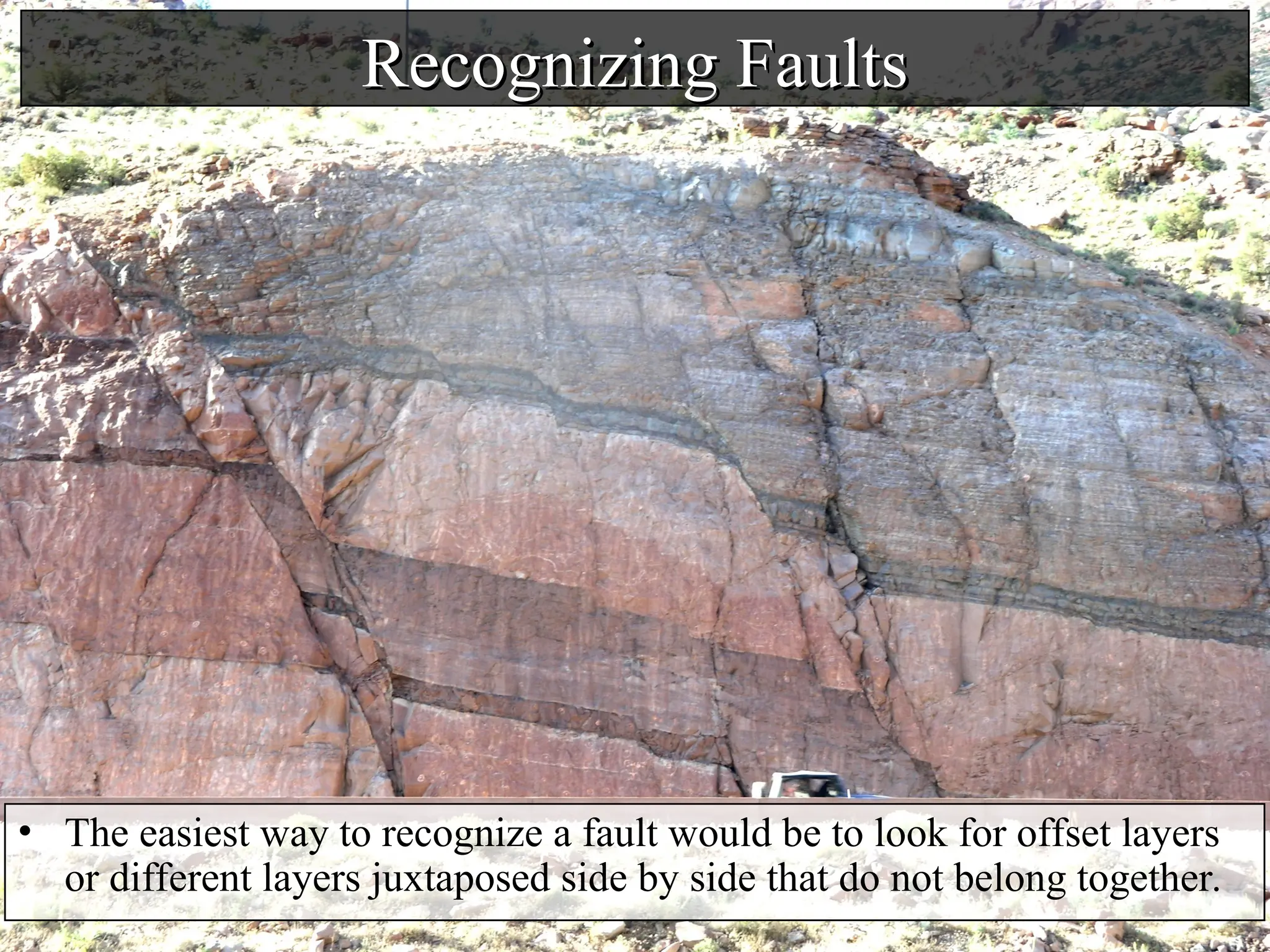
Recognizing Faults
Recognizing Faults
•The easiest way to recognize a fault would be to look for offset layers
or different layers juxtaposed side by side that do not belong together.
24.
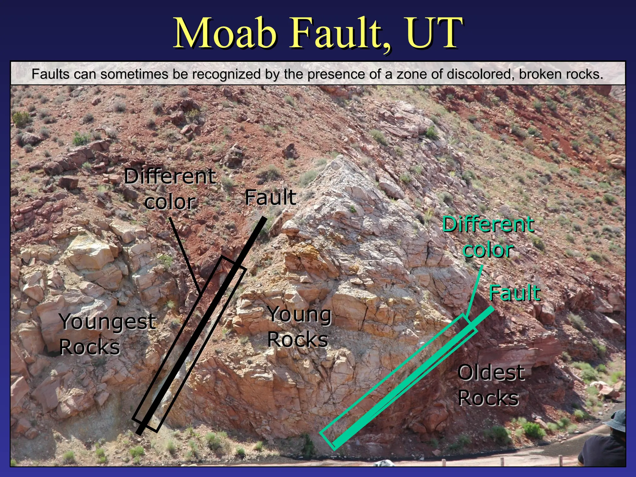
Moab Fault, UT
MoabFault, UT
Different
Different
color
color
Different
Different
color
color
Fault
Fault
Fault
Fault
Youngest
Youngest
Rocks
Rocks
Young
Young
Rocks
Rocks
Oldest
Oldest
Rocks
Rocks
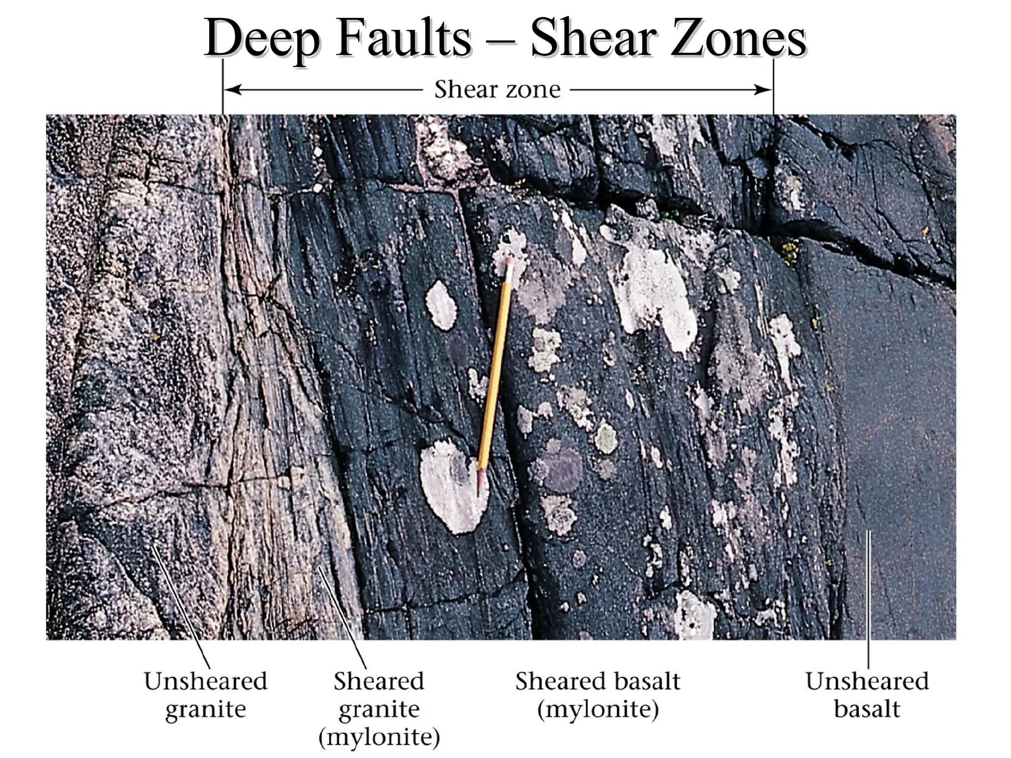
Faults can sometimes be recognized by the presence of a zone of discolored, broken rocks.
Faults can sometimes be recognized by the presence of a zone of discolored, broken rocks.
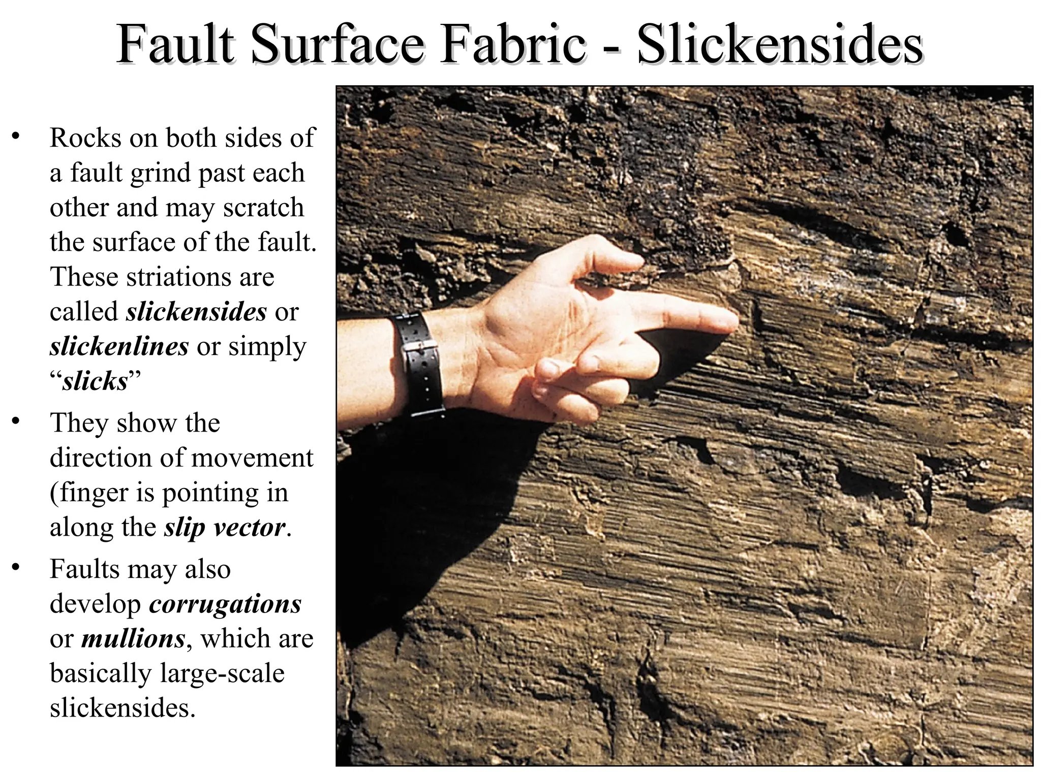
Fault Surface Fabric- Slickensides
Fault Surface Fabric - Slickensides
• Rocks on both sides of
a fault grind past each
other and may scratch
the surface of the fault.
These striations are
called slickensides or
slickenlines or simply
“slicks”
• They show the
direction of movement
(finger is pointing in
along the slip vector.
• Faults may also
develop corrugations
or mullions, which are
basically large-scale
slickensides.
27.
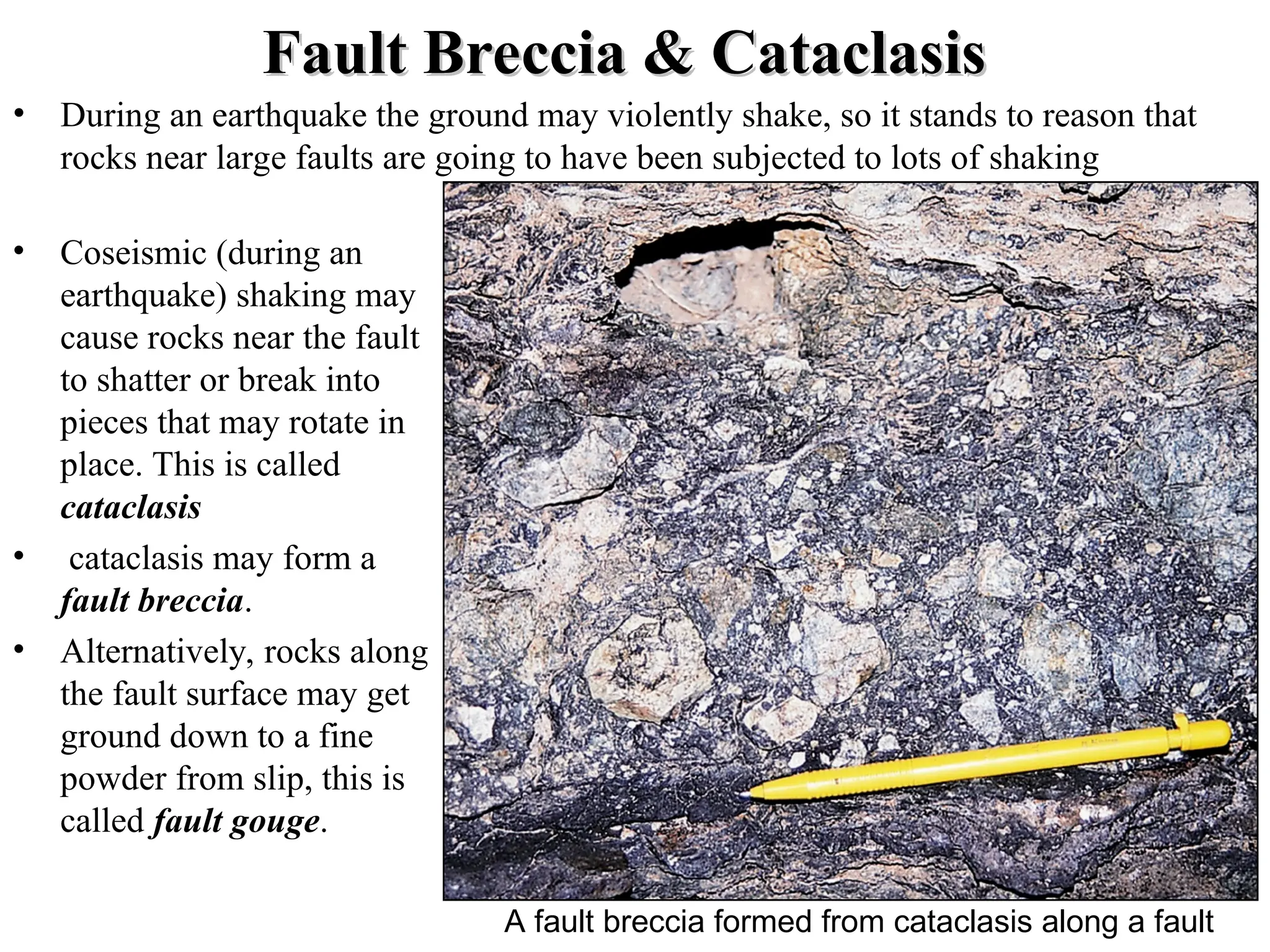
Fault Breccia &Cataclasis
Fault Breccia & Cataclasis
• During an earthquake the ground may violently shake, so it stands to reason that
rocks near large faults are going to have been subjected to lots of shaking
• Coseismic (during an
earthquake) shaking may
cause rocks near the fault
to shatter or break into
pieces that may rotate in
place. This is called
cataclasis
• cataclasis may form a
fault breccia.
• Alternatively, rocks along
the fault surface may get
ground down to a fine
powder from slip, this is
called fault gouge.
A fault breccia formed from cataclasis along a fault
28.
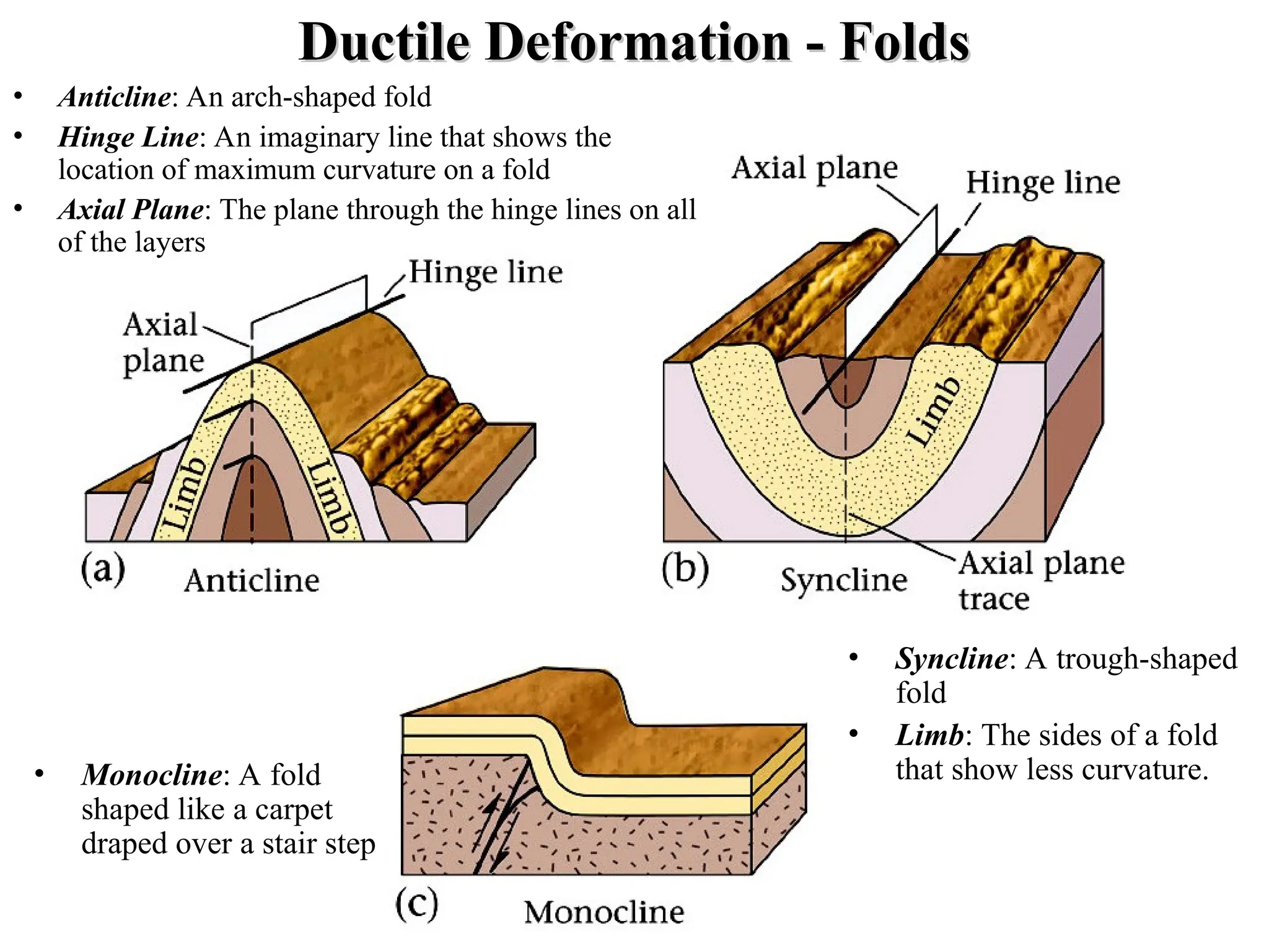
Ductile Deformation -Folds
Ductile Deformation - Folds
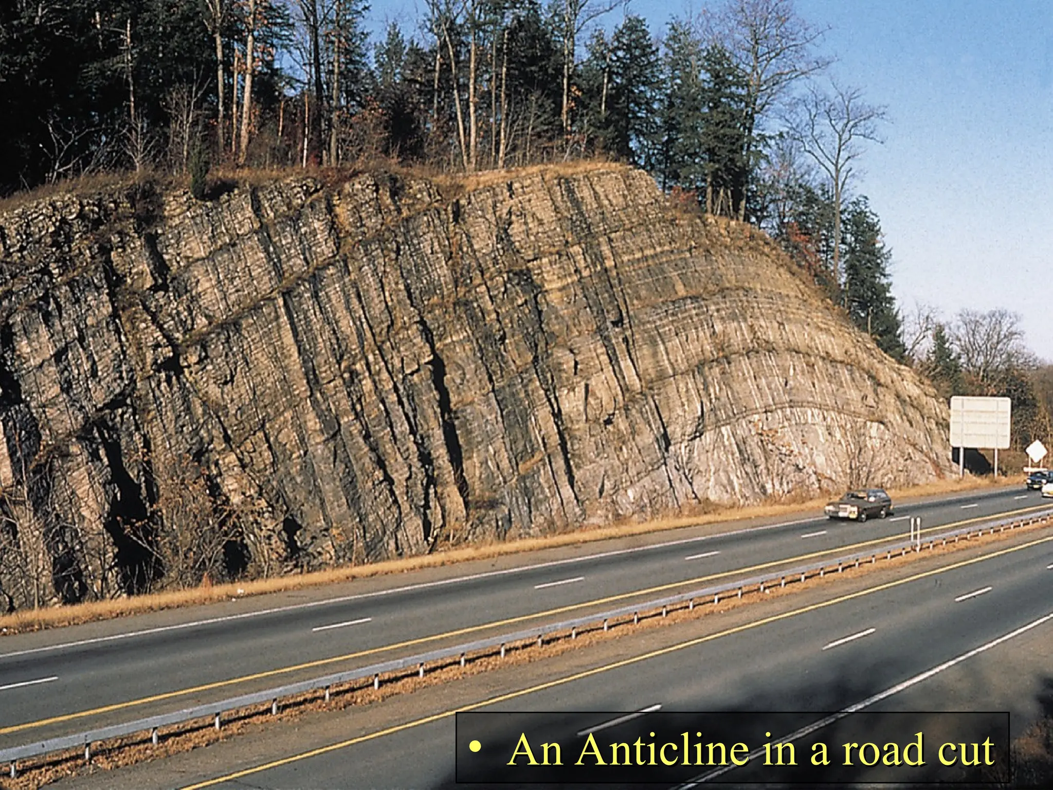
• Anticline: An arch-shaped fold
• Hinge Line: An imaginary line that shows the
location of maximum curvature on a fold
• Axial Plane: The plane through the hinge lines on all
of the layers
• Monocline: A fold
shaped like a carpet
draped over a stair step
• Syncline: A trough-shaped
fold
• Limb: The sides of a fold
that show less curvature.
29.
Descriptive Fold Terms
DescriptiveFold Terms
In order for geologists to describe folds we
need to have terms to describe them
• Open Fold: A fold that is broad, i.e.
the angle between the limbs is large
• Tight Fold: A fold that is narrow,
i.e. the angle between limbs is small
• Plunging Fold: The hinge
line is non-horizontal
• Non-plunging Fold: The
hinge line is horizontal
Doubly Plunging Folds form
domes and basins
• Dome: An upside-down
bowl-shaped fold
• Basin: A right-side-up
bowl-shaped fold
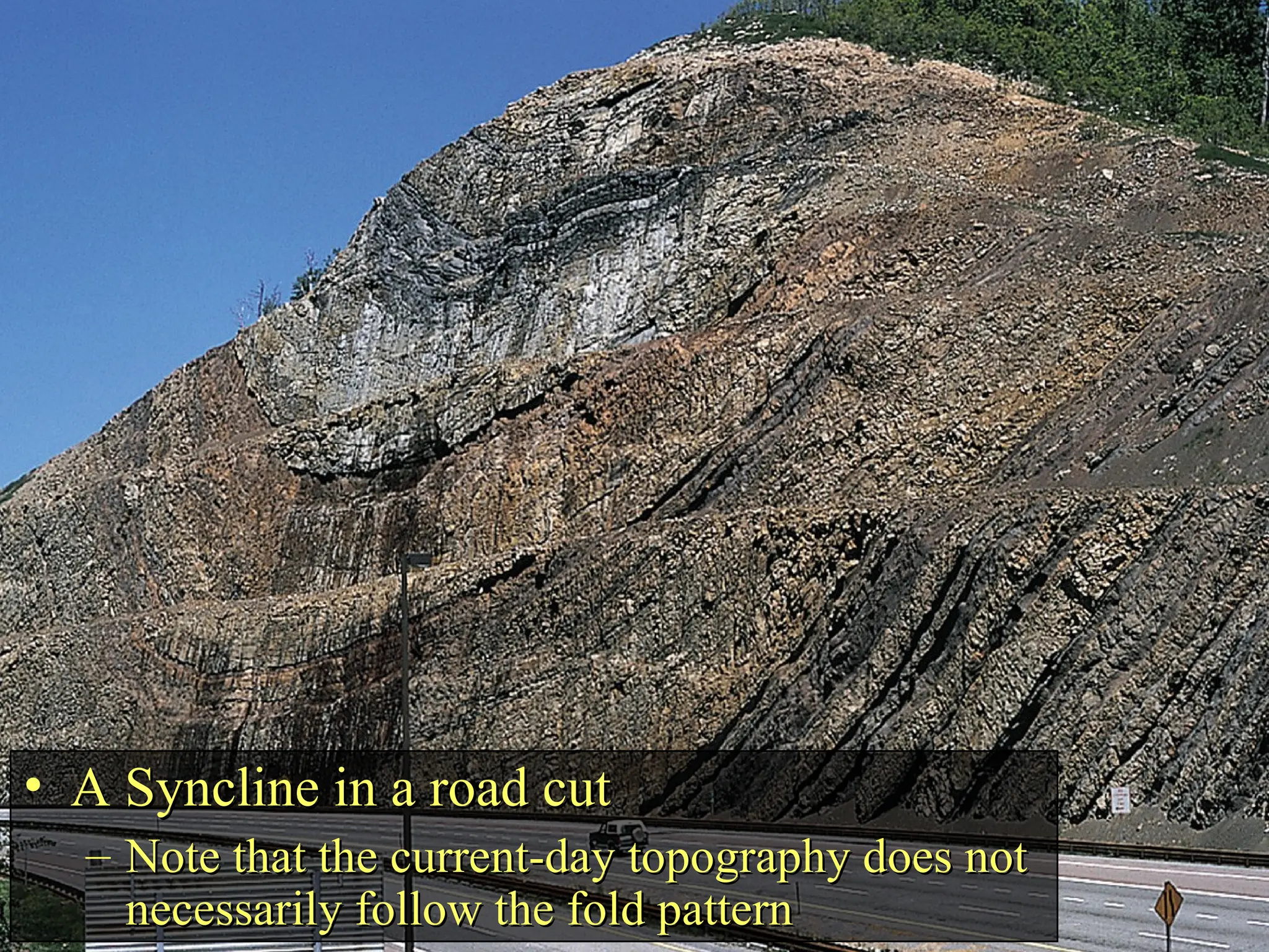
• A Synclinein a road cut
A Syncline in a road cut
– Note that the current-day topography does not
Note that the current-day topography does not
necessarily follow the fold pattern
necessarily follow the fold pattern
32.
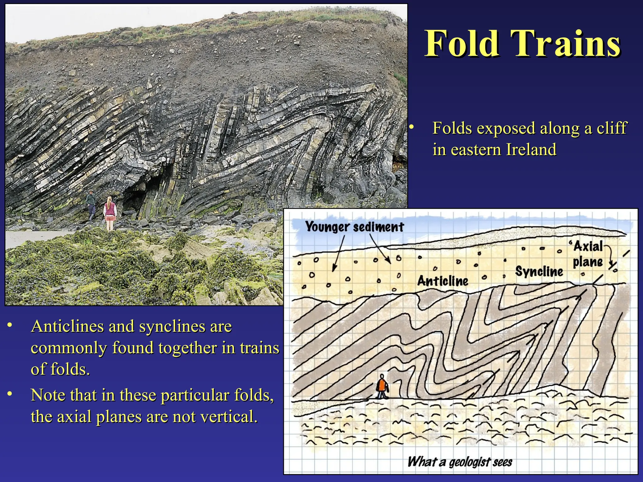
Fold Trains
Fold Trains
•Anticlines and synclines are
Anticlines and synclines are
commonly found together in trains
commonly found together in trains
of folds.
of folds.
• Note that in these particular folds,
Note that in these particular folds,
the axial planes are not vertical.
the axial planes are not vertical.
• Folds exposed along a cliff
Folds exposed along a cliff
in eastern Ireland
in eastern Ireland
33.
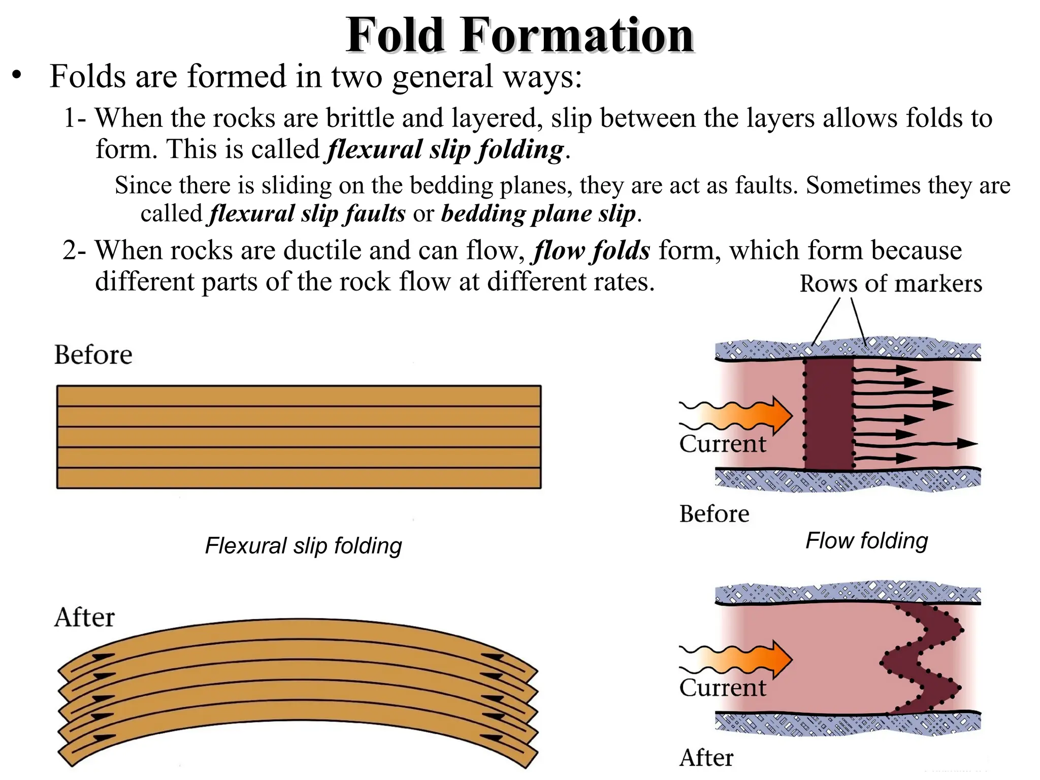
Fold Formation
Fold Formation
•Folds are formed in two general ways:
1- When the rocks are brittle and layered, slip between the layers allows folds to
form. This is called flexural slip folding.
Since there is sliding on the bedding planes, they are act as faults. Sometimes they are
called flexural slip faults or bedding plane slip.
2- When rocks are ductile and can flow, flow folds form, which form because
different parts of the rock flow at different rates.
Flexural slip folding Flow folding
34.
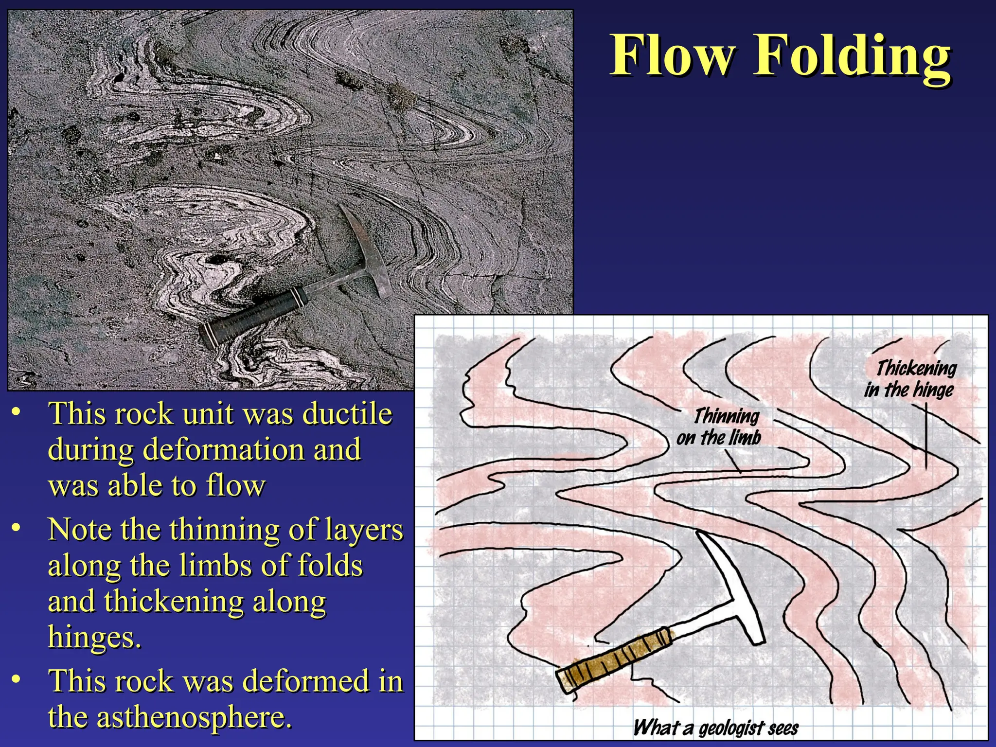
Flow Folding
Flow Folding
•This rock unit was ductile
This rock unit was ductile
during deformation and
during deformation and
was able to flow
was able to flow
• Note the thinning of layers
Note the thinning of layers
along the limbs of folds
along the limbs of folds
and thickening along
and thickening along
hinges.
hinges.
• This rock was deformed in
This rock was deformed in
the asthenosphere.
the asthenosphere.
35.
Flexural Slip
Flexural Slip
Folding
Folding
•Layers are folded with
Layers are folded with
significant slip on the
significant slip on the
bedding planes.
bedding planes.
• Layer thickness stays
Layer thickness stays
constant throughout.
constant throughout.
• May see slickensides on
May see slickensides on
bedding planes
bedding planes
36.
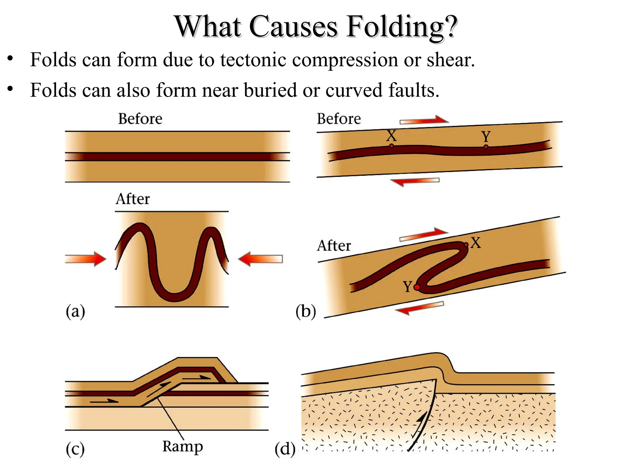
What Causes Folding?
WhatCauses Folding?
• Folds can form due to tectonic compression or shear.
• Folds can also form near buried or curved faults.
37.
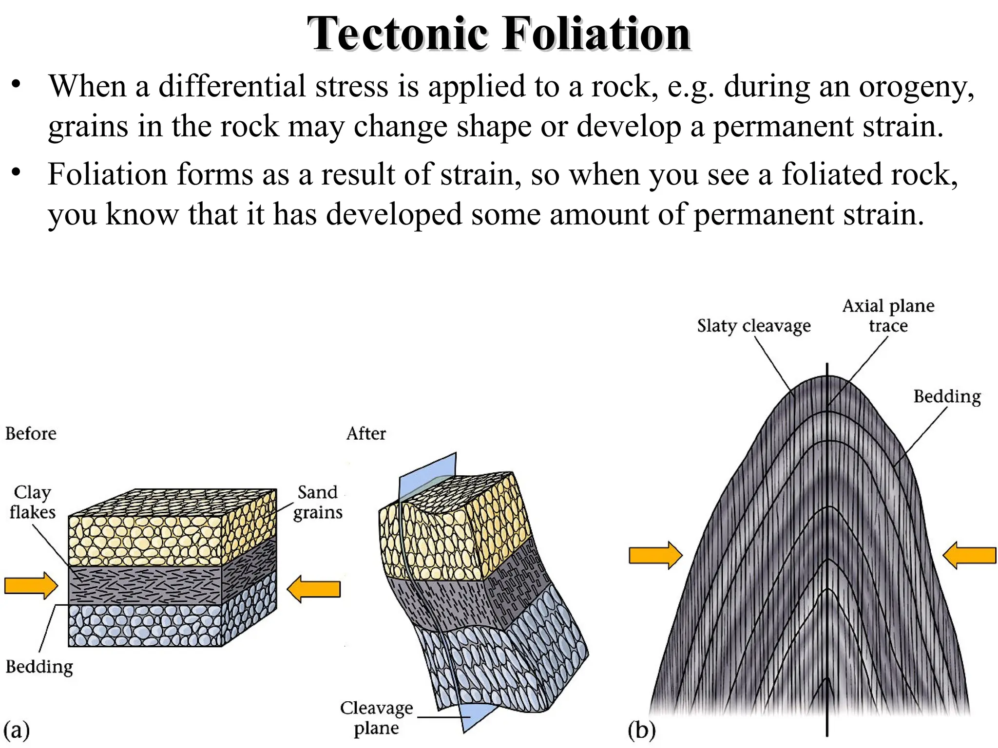
Tectonic Foliation
Tectonic Foliation
•When a differential stress is applied to a rock, e.g. during an orogeny,
grains in the rock may change shape or develop a permanent strain.
• Foliation forms as a result of strain, so when you see a foliated rock,
you know that it has developed some amount of permanent strain.
38.
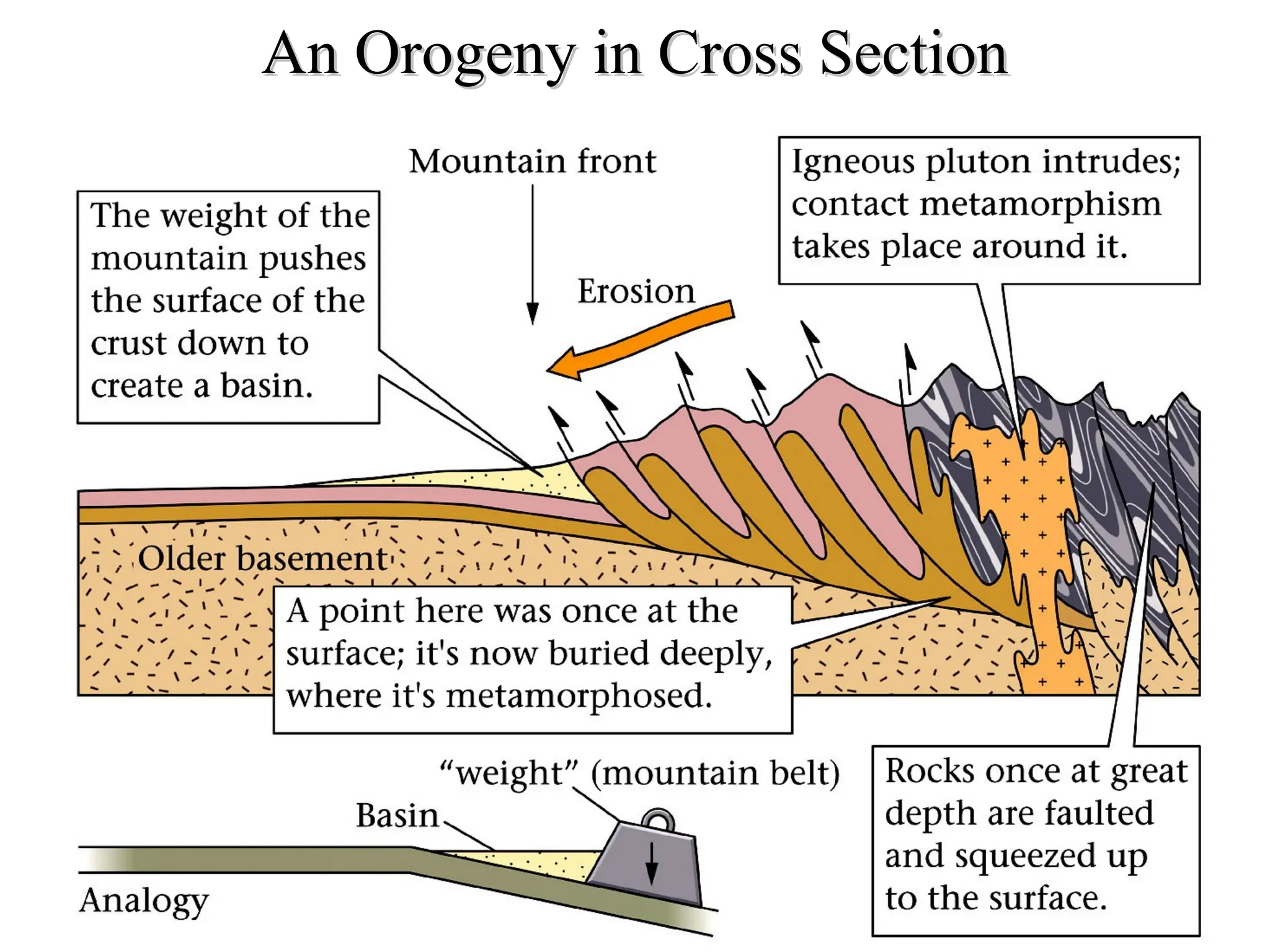
An Orogeny inCross Section
An Orogeny in Cross Section
39.
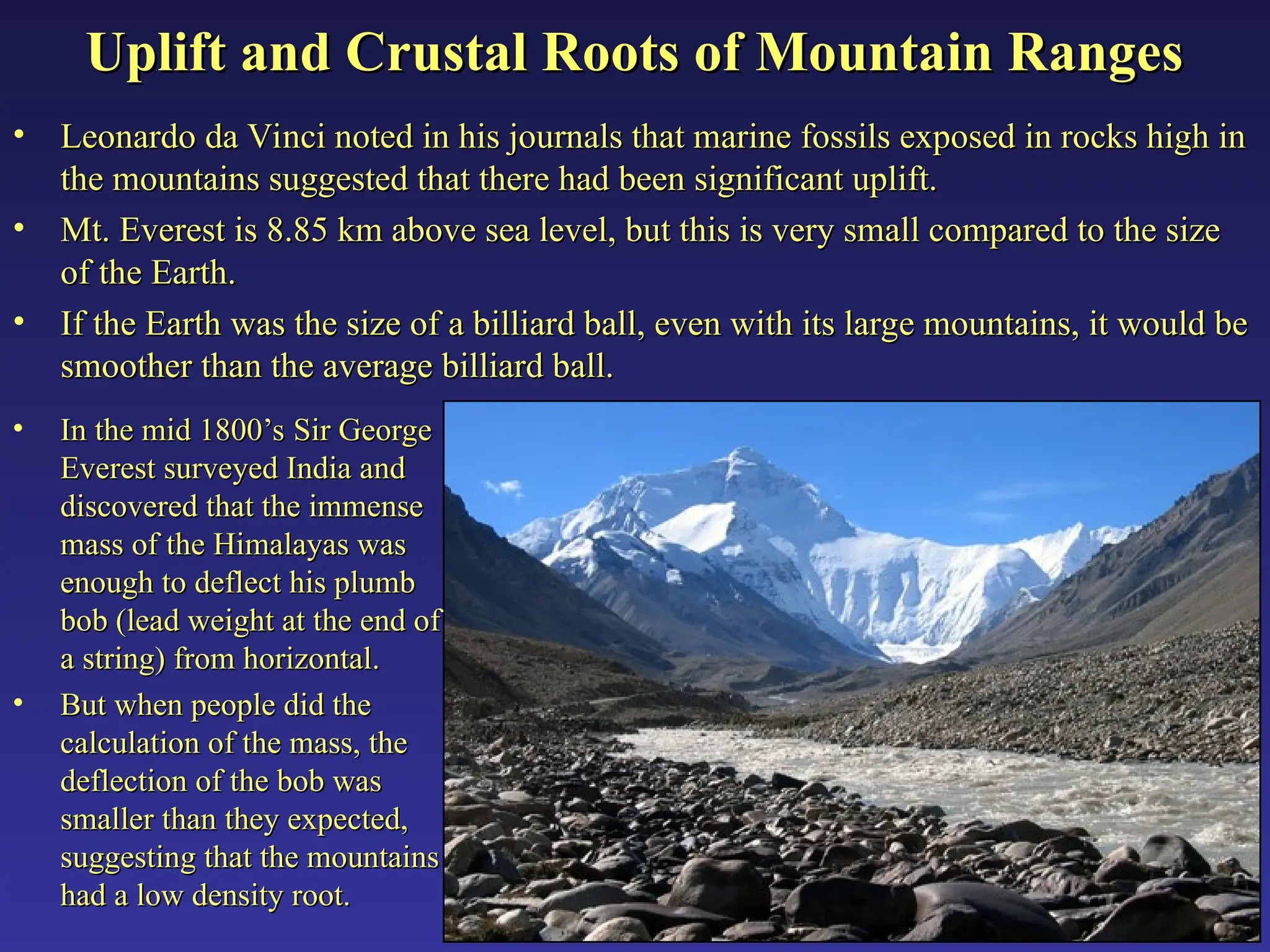
Uplift and CrustalRoots of Mountain Ranges
Uplift and Crustal Roots of Mountain Ranges
• Leonardo da Vinci noted in his journals that marine fossils exposed in rocks high in
Leonardo da Vinci noted in his journals that marine fossils exposed in rocks high in
the mountains suggested that there had been significant uplift.
the mountains suggested that there had been significant uplift.
• Mt. Everest is 8.85 km above sea level, but this is very small compared to the size
Mt. Everest is 8.85 km above sea level, but this is very small compared to the size
of the Earth.
of the Earth.
• If the Earth was the size of a billiard ball, even with its large mountains, it would be
If the Earth was the size of a billiard ball, even with its large mountains, it would be
smoother than the average billiard ball.
smoother than the average billiard ball.
• In the mid 1800’s Sir George
In the mid 1800’s Sir George
Everest surveyed India and
Everest surveyed India and
discovered that the immense
discovered that the immense
mass of the Himalayas was
mass of the Himalayas was
enough to deflect his plumb
enough to deflect his plumb
bob (lead weight at the end of
bob (lead weight at the end of
a string) from horizontal.
a string) from horizontal.
• But when people did the
But when people did the
calculation of the mass, the
calculation of the mass, the
deflection of the bob was
deflection of the bob was
smaller than they expected,
smaller than they expected,
suggesting that the mountains
suggesting that the mountains
had a low density root.
had a low density root.
40.
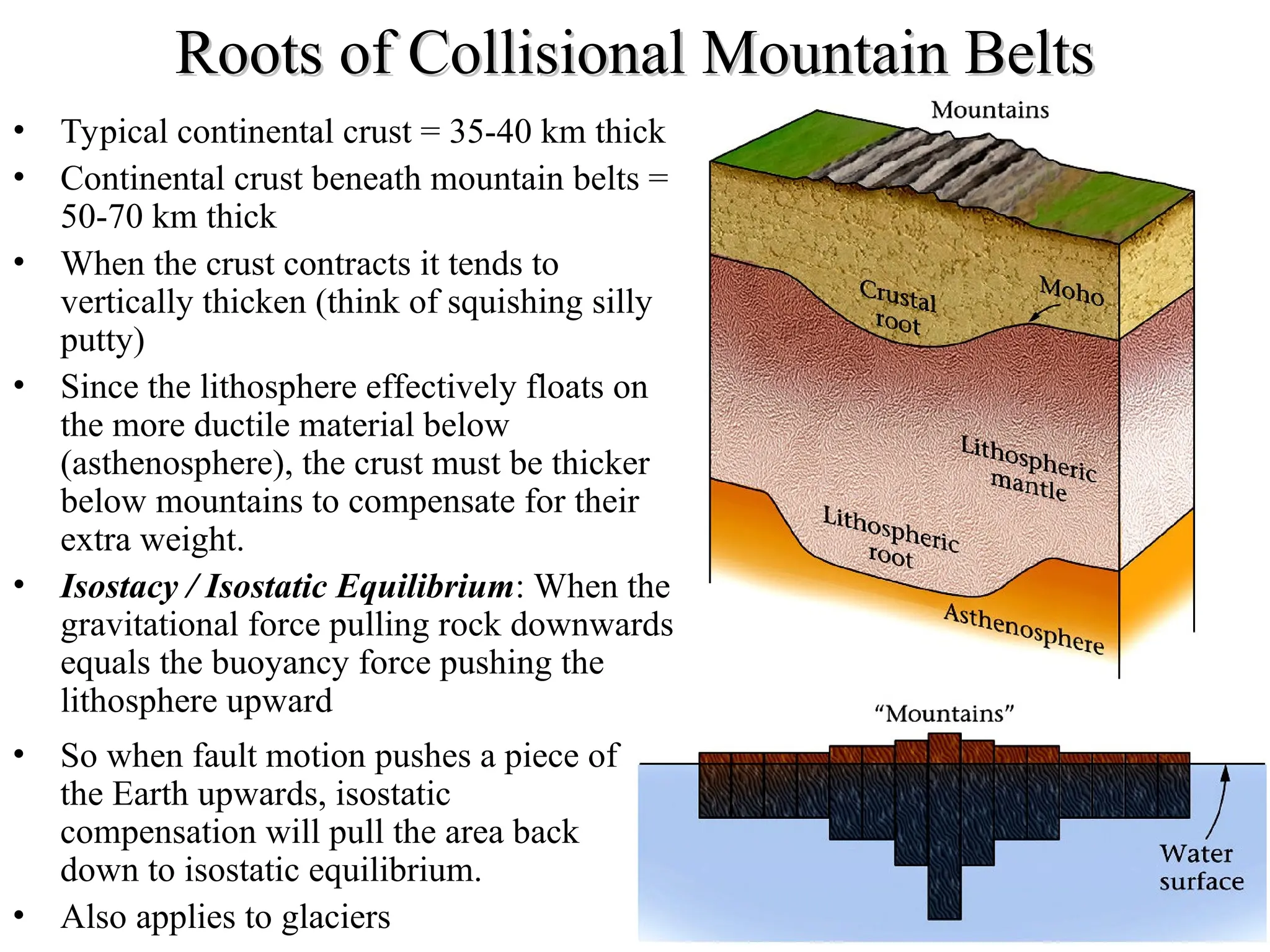
Roots of CollisionalMountain Belts
Roots of Collisional Mountain Belts
• Typical continental crust = 35-40 km thick
• Continental crust beneath mountain belts =
50-70 km thick
• When the crust contracts it tends to
vertically thicken (think of squishing silly
putty)
• Since the lithosphere effectively floats on
the more ductile material below
(asthenosphere), the crust must be thicker
below mountains to compensate for their
extra weight.
• Isostacy / Isostatic Equilibrium: When the
gravitational force pulling rock downwards
equals the buoyancy force pushing the
lithosphere upward
• So when fault motion pushes a piece of
the Earth upwards, isostatic
compensation will pull the area back
down to isostatic equilibrium.
• Also applies to glaciers
41.
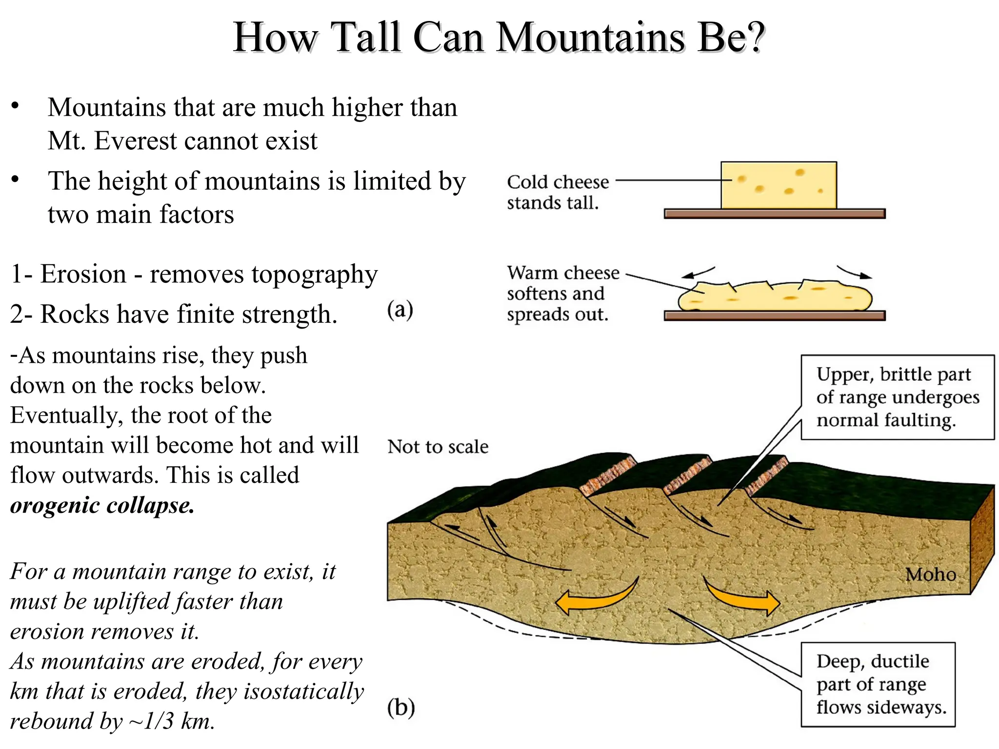
How Tall CanMountains Be?
How Tall Can Mountains Be?
• Mountains that are much higher than
Mt. Everest cannot exist
• The height of mountains is limited by
two main factors
1- Erosion - removes topography
2- Rocks have finite strength.
-As mountains rise, they push
down on the rocks below.
Eventually, the root of the
mountain will become hot and will
flow outwards. This is called
orogenic collapse.
For a mountain range to exist, it
must be uplifted faster than
erosion removes it.
As mountains are eroded, for every
km that is eroded, they isostatically
rebound by ~1/3 km.
42.
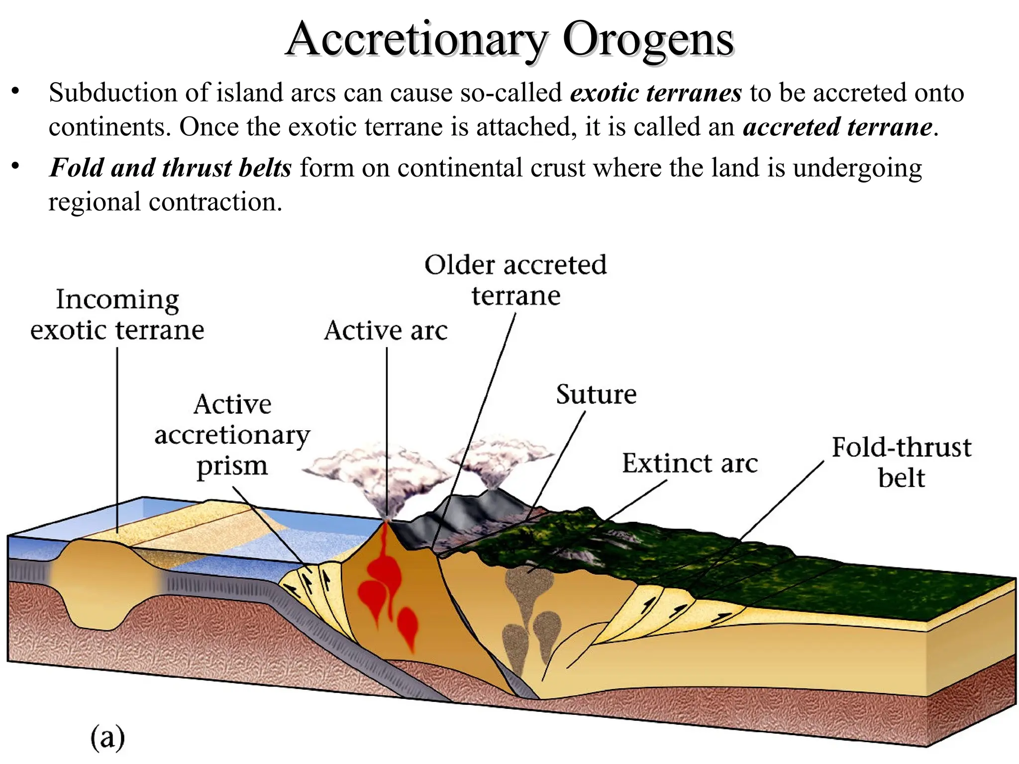
Accretionary Orogens
Accretionary Orogens
•Subduction of island arcs can cause so-called exotic terranes to be accreted onto
continents. Once the exotic terrane is attached, it is called an accreted terrane.
• Fold and thrust belts form on continental crust where the land is undergoing
regional contraction.
43.
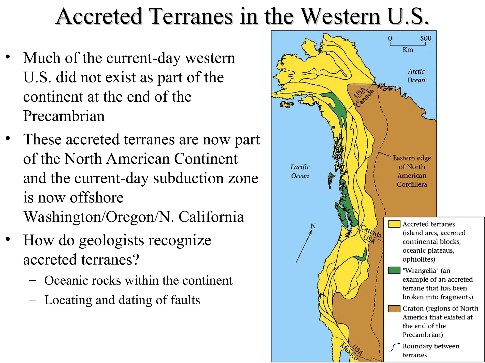
Accreted Terranes inthe Western U.S.
Accreted Terranes in the Western U.S.
• Much of the current-day western
U.S. did not exist as part of the
continent at the end of the
Precambrian
• These accreted terranes are now part
of the North American Continent
and the current-day subduction zone
is now offshore
Washington/Oregon/N. California
• How do geologists recognize
accreted terranes?
– Oceanic rocks within the continent
– Locating and dating of faults
44.
Other Ways toForm
Other Ways to Form
Mountain Belts
Mountain Belts
• Mountain belts
can also form
due to
continent-
continent
collisions
• Continental rifts
can also form
fault block
mountain belts
45.
Measuring
Measuring
Modern
Modern
Orogens
Orogens
• Today, geologistsand
geophysicists can
measure motions in
active orogens, such as
the Andes Mountains
in South America
• Using satellites-based
techniques (GPS,
InSAR, LIDAR) we
can watch these
modern mountain belts
move horizontally and
vertically by
millimeters each year.