This document discusses map projections and their properties. It begins by defining a map and map scale. It then explains that a map projection is a transformation from the spherical Earth onto a flat surface, which inevitably causes some distortion. Projections are classified based on the surface used, and the main types are cylindrical, conic, and planar/azimuthal. Several commonly used projections are described, including Mercator, UTM, Lambert Conformal Conic, and Albers Equal-Area Conic. The document concludes that map projections allow the representation of the spherical Earth on a flat plane and are essential for mapmaking.
INTRODUCTION
• A mapis a representationof all or part of the
Earth drawn on a flat surface at a specific
scale.
• It is a visual representation of an area – a
symbolic depiction highlighting relationships
between elements of that space such as
objects, regions, and themes.
• It is a diagrammatic representation of the
earth's surface or part of it, showing the
geographical distributions, positions, etc. of
natural or artificial features such as roads,
towns, relief, etc.
• Cartography is the study and practice of
making maps and one who make maps is
called a cartographer.
5.
MAP SCALE
• Mapscale refers to the relationship
(or ratio) between distance on a
map and the corresponding
distance on the ground. For
example, on a 1:100 000 scale map,
1cm on the map equals 1km on the
ground.
• The map scale may be expressed in
three ways and the pictorial
representationof these three types
is shown in the figure.
6.
MAP PROJECTION
• Amap projection is a systematic
transformation of the latitudes and longitudes
of locations on the surface of a sphere or an
ellipsoid into locations on a plane.
• It is the representation of the objects and
information on a curved surface in a plane
using mathematicaland geometric relations.
• Transformation from the earth surface to a flat
surface always involves distortion either in
size, shape or in relative location and therefore
no map projection is perfect.
7.
1. The term‘projection’ comes from the notion of placing a light source inside
transparent globe and projecting shadows of the meridians, parallels and other
geographic features onto a sheet of paper placed tangent to the globe.
2. Position of light source can be-
o Gnomonic i.e light source is at the centre.
o Stereographic- light source is at the antipode of the point of tangency.
oOrthographic- light source is at an infinite distance from the point of
tangency.
8.
❑When transferring theimage of the earth
and its irregularities on the plane surface of
the map, three factors involved, they are
➢ Geoid: Rendition of irregular spheroidal
shape of the earth.
➢ An ellipsoid: Geoids are then transferred
to a regular geometric reference surface
➢ Projection: Geographical relationship of
the ellipsoid, still three dimensional
form, are transformed into two
dimensional plane of a map.
CLASSIFICATIONS
OF MAP
PROJECTIONS
• Themap projection are classified according to
five criteria :
1. Nature of the projection surface as
defined by geometry
2. Coincidence or contact of the projection
surface with the datum surface
3. Position or alignment of the projection
surface with relation to the datum
surface
4. Properties of cartographic requirements,
and
5. Mode of generation of datum surface
and coordinate systems.
11.
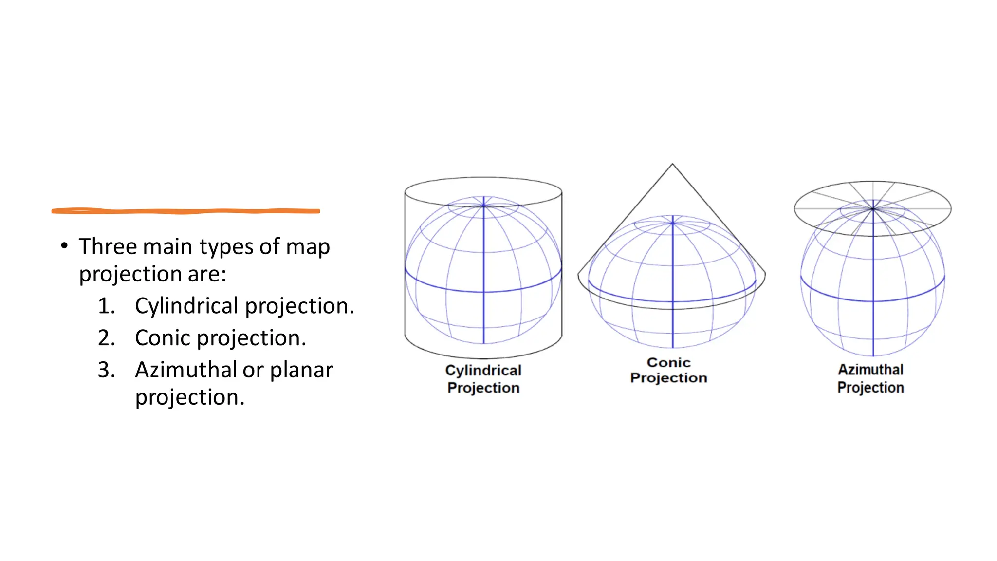
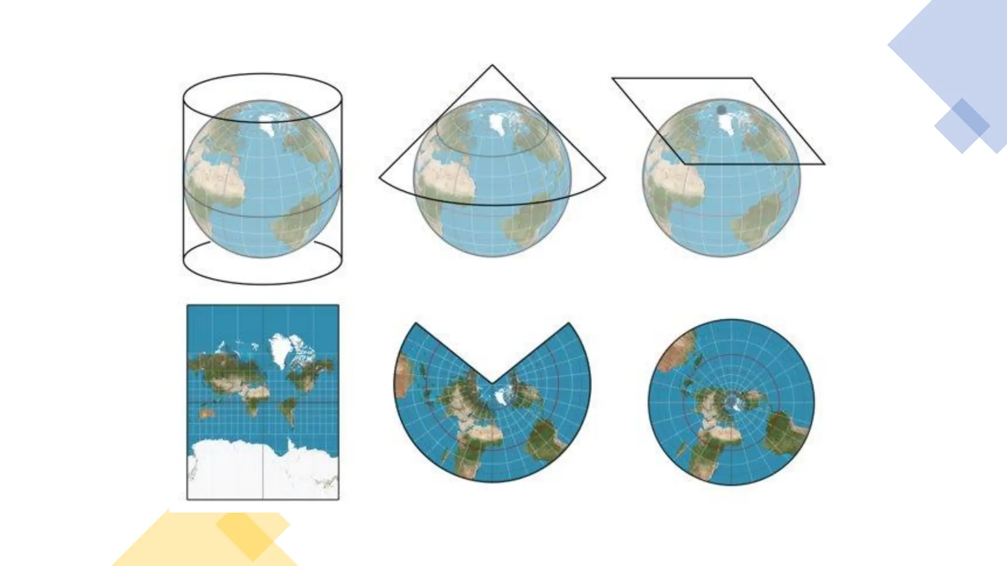
• Three maintypes of map
projection are:
1. Cylindrical projection.
2. Conic projection.
3. Azimuthal or planar
projection.
13.
1.Cylindrical
projection
• Wrap asheet of paper around
the globe in the form of a
cylinder, transfer the
geographic features of the
globe on to it. Then unroll the
sheet and lay it.
• To achieve projection, the
graticule would be rectangular,
the cylinder tangent to one
line on the globe or intersects
two line of the globe.
14.
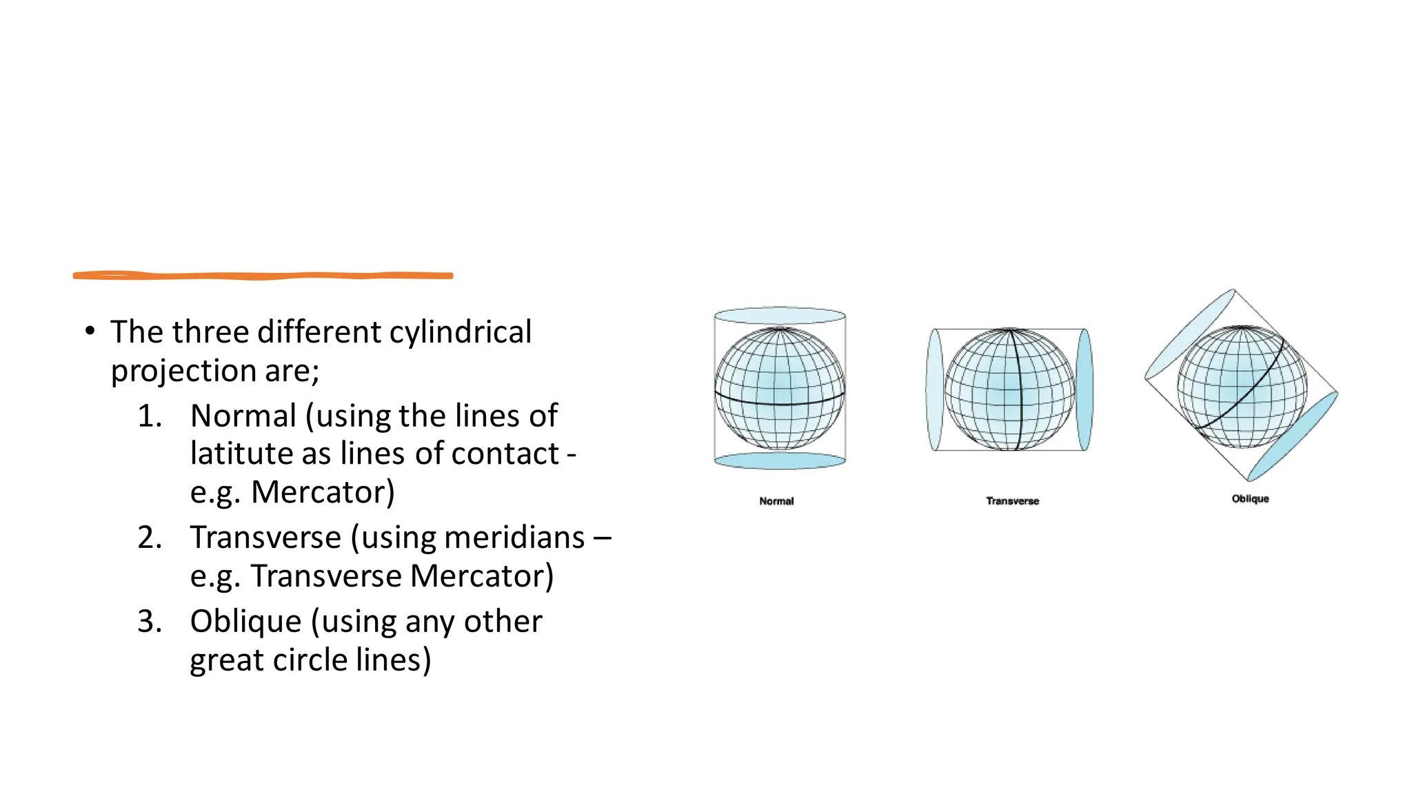
• The threedifferent cylindrical
projection are;
1. Normal (using the lines of
latitute as lines of contact -
e.g. Mercator)
2. Transverse (using meridians –
e.g. Transverse Mercator)
3. Oblique (using any other
great circle lines)
15.
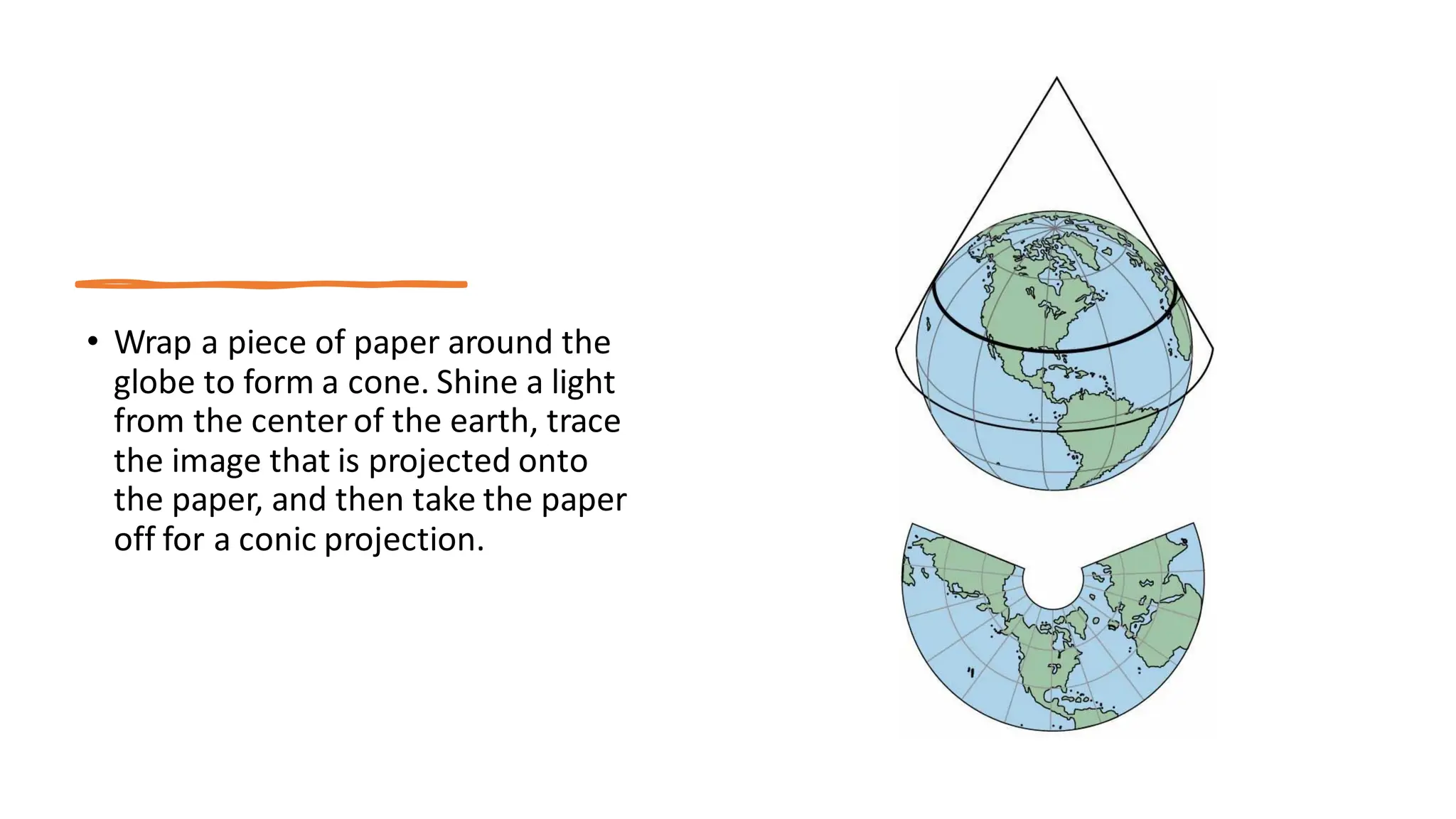
2. CONIC
PROJECTION
• Amethod of projecting maps of parts of
the earth's spherical surface on a
surrounding cone, which is then flattened
to a plane surface having concentric
circles as parallels of latitude and
radiating lines from the apex as
meridians.
• A cone is placed over the earth, normally
tangent to one or more lines of latitude. A
conic projection works best over mid
latitudes for this reason.
16.
• Wrap apiece of paper around the
globe to form a cone. Shine a light
from the center of the earth, trace
the image that is projected onto
the paper, and then take the paper
off for a conic projection.
17.
3. Azimuthal or
planar
projection.
•A map projection in which a globe, as of the
Earth, is assumed to rest on a flat surface onto
which its features are projected.
• It is a one of the important projection result
from projecting a spherical surface in to plane.
• In this projection a flat paper is supposed to
touch the globe at one point and project the
lines of latitude and longitude on a plane. This
type of projection usually tangent to the globe
at one point, but may be secant.
• The point of contactmay be north pole, south
pole, a point on the equatorial or any point in
between.
18.
• Azimuthal orplanar projection are
of three different types;
1. Polar (using either north or
south pole)
2. Equatorial (using a point
somewhere on the Equator)
3. Oblique (using any other
point)
Azimuthal or plane projection
1. MERCATOR
PROJECTION
• TheMercatorprojection has
straight meridians and parallels
that intersect at right angles.
• Scales can be used to measure
distances and are true only along
equator or at two standard
parallels equidistant at the equator.
• This projection is often used for
navigation for maps of equatorial
regions.
21.
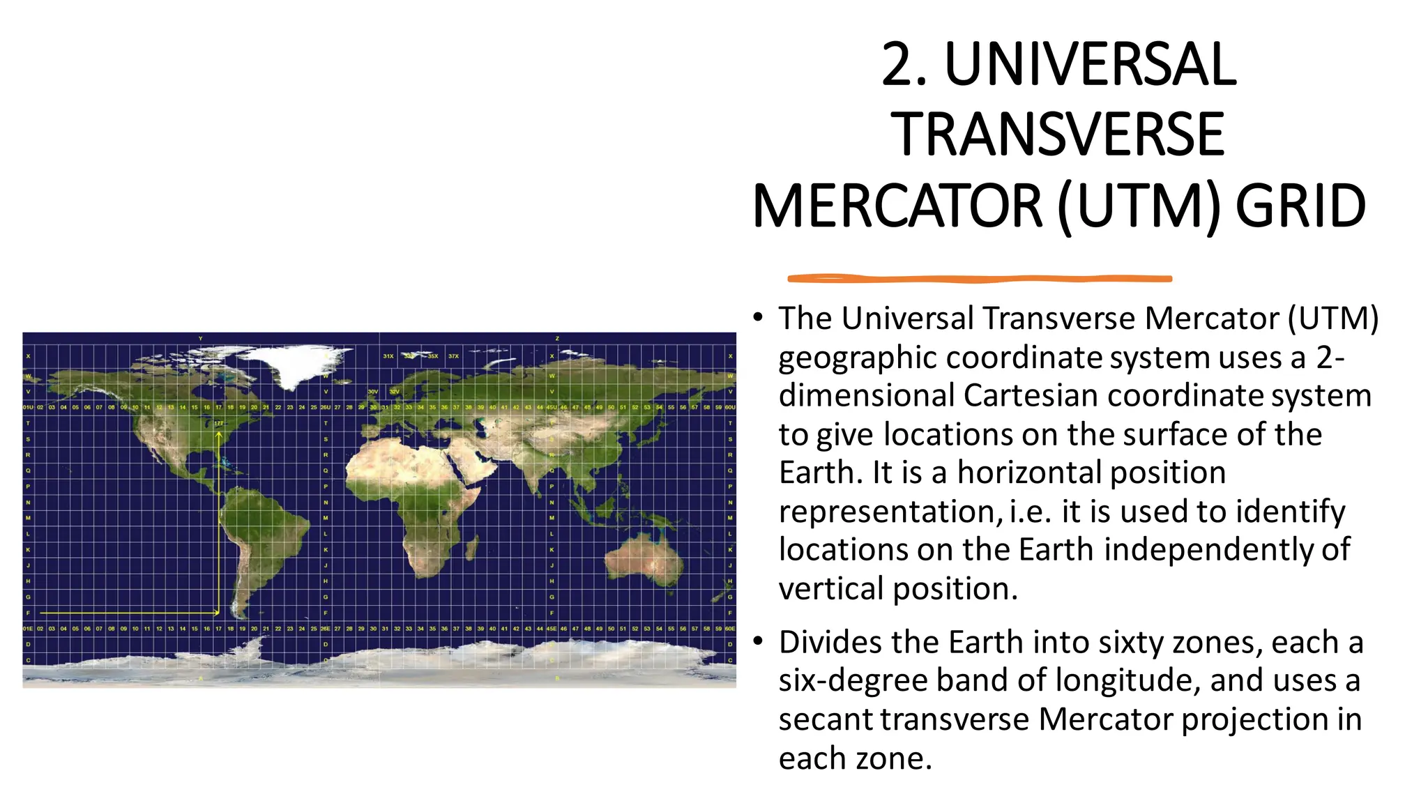
2. UNIVERSAL
TRANSVERSE
MERCATOR (UTM)GRID
• The Universal Transverse Mercator (UTM)
geographic coordinate system uses a 2-
dimensional Cartesian coordinate system
to give locations on the surface of the
Earth. It is a horizontal position
representation,i.e. it is used to identify
locations on the Earth independently of
vertical position.
• Divides the Earth into sixty zones, each a
six-degree band of longitude, and uses a
secant transverse Mercator projection in
each zone.
22.
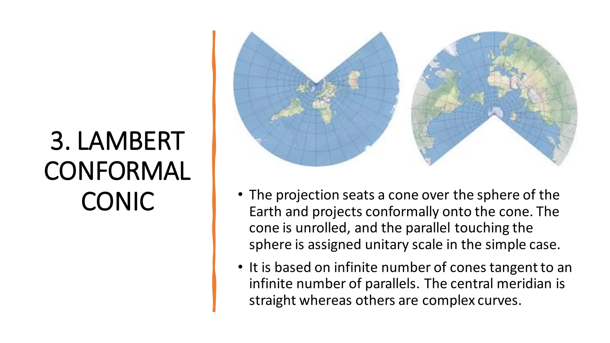
3. LAMBERT
CONFORMAL
CONIC •The projection seats a cone over the sphere of the
Earth and projects conformally onto the cone. The
cone is unrolled, and the parallel touching the
sphere is assigned unitary scale in the simple case.
• It is based on infinite number of cones tangent to an
infinite number of parallels. The central meridian is
straight whereas others are complex curves.
23.
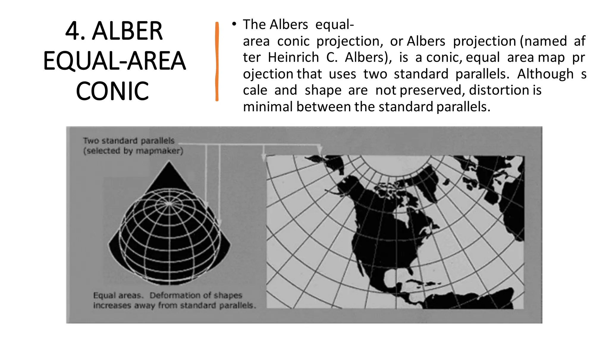
4. ALBER
EQUAL-AREA
CONIC
• TheAlbers equal-
area conic projection, or Albers projection (named af
ter Heinrich C. Albers), is a conic, equal area map pr
ojection that uses two standard parallels. Although s
cale and shape are not preserved, distortion is
minimal between the standard parallels.
24.
CONCLUSION
• Map isa visual representation or diagrammatic representation of the earth's sur
face or part of it, showing the geographical distributions, positions, etc, of na
tural or artificial features.
• It has different scale and base on the range scale of the map it can be either large
, medium or small map.
• A map projection is a systematic transformation of the latitudes and longitud
es of locations on the surface of a sphere or an ellipsoid into locations on a p
lane.
• There are mainly three main categories or classification of map projection i.
e cylindrical, conic and planar/Azimuthal projection.
• Map projection is thus the basic principle of map making.


![CTR_ppresentation[1RRRRRRRRRRRRRRRRR].pptx](https://cdn.slidesharecdn.com/ss_thumbnails/ctrppresentation1-250330155714-ac87e8bd-thumbnail.jpg?width=640&height=640&fit=bounds)


