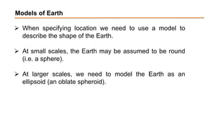
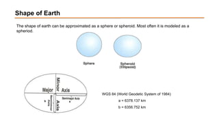
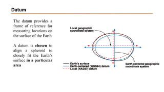
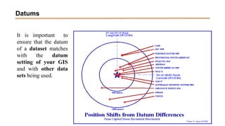
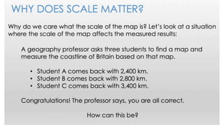
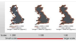
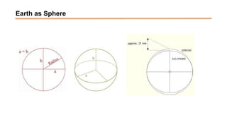
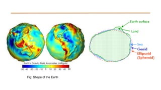
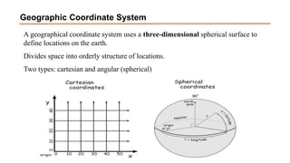
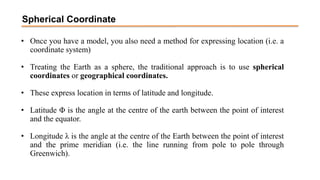
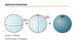
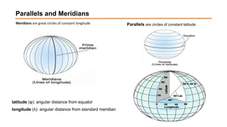
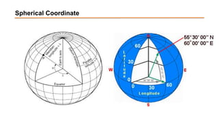
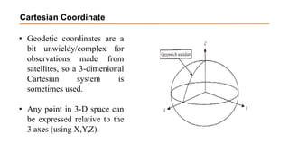
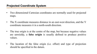
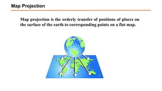
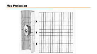
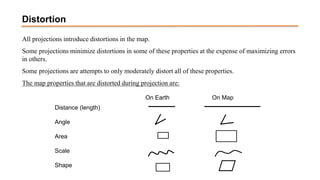
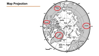
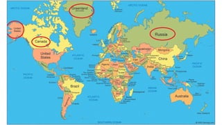
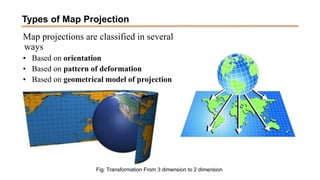
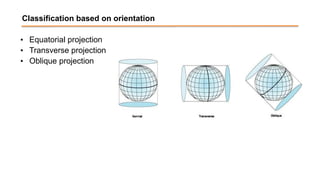
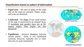
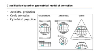
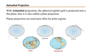
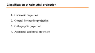
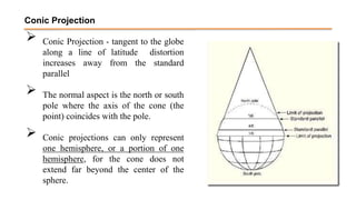
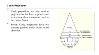
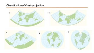
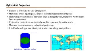
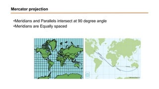
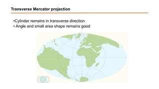
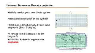
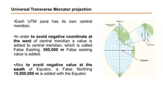
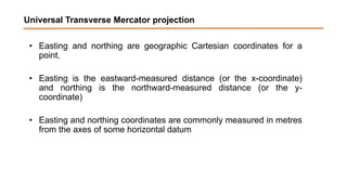
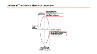
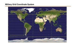
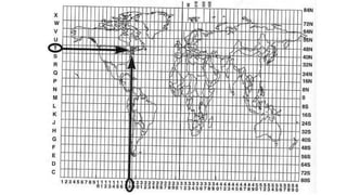
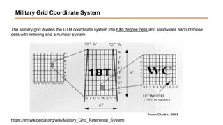
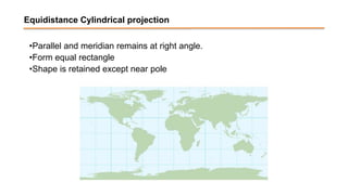
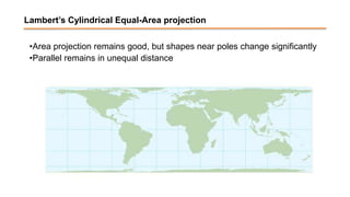
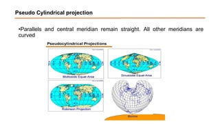
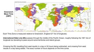
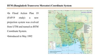
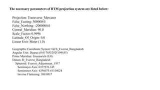
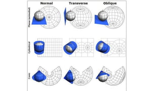
SlideShare a Scribd company logo
1 of 61
Download to read offline
Spatial Coordinate System
Models of Earth
 When specifying location we need to use a model to
describe the shape of the Earth.
 At small scales, the Earth may be assumed to be round
(i.e. a sphere).
 At larger scales, we need to model the Earth as an
ellipsoid (an oblate spheroid).
The shape of earth can be approximated as a sphere or spheroid. Most often it is modeled as a
spheriod.
a
b
WGS 84 (World Geodetic System of 1984)
a = 6378.137 km
b = 6356.752 km
Shape of Earth
The datum provides a
frame of reference for
measuring locations on
the surface of the Earth
A datum is chosen to
align a spheroid to
closely fit the Earth’s
surface in a particular
area
Datum
It is important to
ensure that the datum
of a dataset matches
with the datum
setting of your GIS
and with other data
sets being used.
Datums
Spatial Scale
• Features on a map are obviously drawn smaller than
their actual size.
• The ratio of the drawn size to actual size is known as
scale. This can be indicated in various ways, e.g.
• 1 inch = 1 mile
• 1 inch = 63,360 inches
• 1:63,630
• The preferred method is the representative fraction
(RF).
• Large scale maps have a larger RF (i.e. they are more
‘zoomed in’ and show more detail)
Spatial Scale
• All maps make a compromise about how much information to show
Earth as Sphere
Fig: Shape of the Earth
Geoid
 An ellipsoid may not be sufficiently accurate for detailed measurements at large
scale.
 It also has ‘bumps’ and ‘hollows’.
 For geodetic measurements, the geoid is used.
 This is defined as the ‘equipotential surface that most closely corresponds to mean
sea level’.
 Mean sea level varies from place to place, so different mapping agencies use slightly
different geoids.
Coordinate System
Usually there are two types of coordinate system
• Geographic coordinate system
• Projected coordinate system
A geographical coordinate system uses a three-dimensional spherical surface to
define locations on the earth.
Divides space into orderly structure of locations.
Two types: cartesian and angular (spherical)
Geographic Coordinate System
Spherical Coordinate
• Once you have a model, you also need a method for expressing location (i.e. a
coordinate system)
• Treating the Earth as a sphere, the traditional approach is to use spherical
coordinates or geographical coordinates.
• These express location in terms of latitude and longitude.
• Latitude Φ is the angle at the centre of the earth between the point of interest
and the equator.
• Longitude λ is the angle at the centre of the Earth between the point of interest
and the prime meridian (i.e. the line running from pole to pole through
Greenwich).
Spherical Coordinate
+ =
Equator - 0̊̊ latitude
Prime Meridian - 0̊̊ longitude
Meridians are great circles of constant longitude
latitude (φ): angular distance from equator
longitude (λ): angular distance from standard meridian
Parallels are circles of constant latitude
Parallels and Meridians
Spherical Coordinate
• By convention the latitude of a place in the northern hemisphere is
positive, and in the southern hemisphere it is negative.
• Places east of Greenwich have a positive longitude, places west
have a negative longitude.
• Degrees were traditionally divided into 60 minutes, and each
minute into 60 seconds.
• For computing purposes, decimal degrees are more normally used.
Cartesian Coordinate
• Geodetic coordinates are a
bit unwieldy/complex for
observations made from
satellites, so a 3-dimenional
Cartesian system is
sometimes used.
• Any point in 3-D space can
be expressed relative to the
3 axes (using X,Y,Z).
Projected Coordinate System
• Two dimensional Cartesian coordinates are normally used for projected
maps.
• The X coordinate measures distance in an east-west direction, and the Y
coordinate measures it in a north-south direction.
• The true origin is at the centre of the map, but because negative values
are unwieldy, a false origin is usually defined to produce positive
values.
• The location of the false origin (i.e. offset) and type of projection
should be specified in the datum.
Measuring Distance
• Measuring distance in a Cartesian system is a simple application of
Pythagoras’s theorem:
• However, the distance estimates will vary depending upon the
projection used.
• Measuring distance using geographic coordinates is more complex
• The calculations are even more complex for geodetic coordinates.
   
y
y
x
x
d
2
1
2
1
2
2

 

 
 
2
1
2
1
2
1
1
cos
cos
cos
sin
sin
cos 




 

 
R
d
Map projection is the orderly transfer of positions of places on
the surface of the earth to corresponding points on a flat map.
Map Projection
Map Projection
• A map projection is a systematic transformation of the latitudes and
longitudes of locations on the surface of a sphere or an ellipsoid into locations
on a plane.
• Map projections are necessary for creating maps. All map projections distort
the surface in some fashion.
• Depending on the purpose of the map, some distortions are acceptable and
others are not; therefore, different map projections exist in order to preserve
some properties of the sphere-like body at the expense of other properties.
• There is no limit to the number of possible map projections.
Map Projection
All projections introduce distortions in the map.
Some projections minimize distortions in some of these properties at the expense of maximizing errors
in others.
Some projections are attempts to only moderately distort all of these properties.
The map properties that are distorted during projection are:
On Earth On Map
Distance (length)
Angle
Area
Scale
Shape
Distortion
Map Projection
Map Projection
Types of Map Projection
Map projections are classified in several
ways
• Based on orientation
• Based on pattern of deformation
• Based on geometrical model of projection
Fig: Transformation From 3 dimension to 2 dimension
Classification based on orientation
• Equatorial projection
• Transverse projection
• Oblique projection
• Equal area – the ratio of areas on the earth
and on the map are constant. Shape, angle,
and scale are distorted.
• Conformal – the shape of any small surface
of the map is preserved in its original form.
If meridians and parallel lines are at 90-
degree angles, then angles are also
preserved.
• Equidistant - preserve distances between
certain points. Scale is not maintained
correctly, however, typically one or more
lines has its scale maintained.
Classification based on pattern of deformation
Classification based on geometrical model of projection
• Azimuthal projection
• Conic projection
• Cylindrical projection
With Azimuthal projections, the spherical (globe) grid is projected onto a
flat plane, thus it is also called a plane projection.
Planar projections are used most often for polar regions.
Polar Equatorial
Azimuthal Projection
Classification of Azimuthal projection
1. Gnomonic projection
2. General Perspective projection
3. Orthographic projection
4. Azimuthal conformal projection
 Conic Projection - tangent to the globe
along a line of latitude distortion
increases away from the standard
parallel
 The normal aspect is the north or south
pole where the axis of the cone (the
point) coincides with the pole.
 Conic projections can only represent
one hemisphere, or a portion of one
hemisphere, for the cone does not
extend far beyond the center of the
sphere.
Conic Projection
• Conic projections are often used to
project areas that have a greater east-
west extent than north-south, such as
the United States.
• Secant Conic projections have two
standard parallels which results in less
distortion
Conic Projection
Classification of Conic Projection
Classification of Conic projection
1. Equidistance Conic
2. Albers Equal Area Projection
3. Lambert Conformal Conic Projection
4. Polyconic Projection
5. Pseudo-Conical Projection
Classification of Conic projection
1. 2.
3.
4.
5.
• Equator is typically the line of tangency
• Meridians are of equal space, lines of latitude increases toward poles
• Transverse projections use meridian lines as tangent point, therefore, North/South
lines are preserved
• Cylindrical projections are typically used to represent the entire world.
• Mercator is most common cylindrical projection
• It is Conformal type and displays true direction along straight lines
Cylindrical Projection
Types of Cylindrical projection
Mercator projection
•Meridians and Parallels intersect at 90 degree angle
•Meridians are Equally spaced
Transverse Mercator projection
•Cylinder remains in transverse direction
• Angle and small area shape remains good
Universal Transverse Mercator projection
•Widely used popular coordinate system
•Transverse orientation of the cylinder
•Total map is longitudinally divided in 60
segments (Each 6 degree)
•It ranges from 84 degree N To 80
degree S.
Arctic and Antarctic regions are
excluded
Universal Transverse Mercator projection
•Each UTM zone has its own central
meridian.
•In order to avoid negative coordinate at
the west of central meridian a value is
added to central meridian, which is called
False Easting. 500,000 m False easting
value is added.
•Also to avoid negative value at the
south of Equator, a False Northing
10,000,000 m is added with the Equator
Universal Transverse Mercator projection
• Easting and northing are geographic Cartesian coordinates for a
point.
• Easting is the eastward-measured distance (or the x-coordinate)
and northing is the northward-measured distance (or the y-
coordinate)
• Easting and northing coordinates are commonly measured in metres
from the axes of some horizontal datum
Universal Transverse Mercator projection
Military Grid Coordinate System
The Military grid divides the UTM coordinate system into 6X8 degree cells and subdivides each of those
cells with lettering and a number system
Military Grid Coordinate System
https://en.wikipedia.org/wiki/Military_Grid_Reference_System
Military Grid Coordinate System
https://en.wikipedia.org/wiki/Military_Grid_Reference_System
Equidistance Cylindrical projection
•Parallel and meridian remains at right angle.
•Form equal rectangle
•Shape is retained except near pole
Lambert’s Cylindrical Equal-Area projection
•Area projection remains good, but shapes near poles change significantly
•Parallel remains in unequal distance
Pseudo Cylindrical projection
•Parallels and central meridian remain straight. All other meridians are
curved
Time Zones
Greenwich
Mean Time
(GMT)
Each Time Zone is measured relative to Greenwich, England (0° line of longitude).
International Date Line (IDL) passes through the middle of the Pacific Ocean, roughly following the 180° line of
longitude but deviating to pass around some territories and island groups
Crossing the IDL travelling from east results in a day or 24 hours being subtracted, and crossing from west
results in a day being added. The exact number of hours depends on the time zones
BTM (Bangladesh Transverse Mercator) Coordinate System
•In Flood Action Plan 19
(FAP19 study) a new
projection system was evolved
from UTM and named as BTM
Coordinate System.
•Introduced in May 1992
The necessary parameters of BTM projection system are listed below:
Projection: Transverse_Mercator
False_Easting: 500000.0
False_Northing: -2000000.0
Central_Meridian: 90.0
Scale_Factor: 0.9996
Latitude_Of_Origin: 0.0
Linear Unit: Meter (1.0)
Geographic Coordinate System: GCS_Everest_Bangladesh
Angular Unit: Degree (0.0174532925199433)
Prime Meridian: Greenwich (0.0)
Datum: D_Everest_Bangladesh
Spheroid: Everest_Adjustment_1937
Semimajor Axis: 6377276.345
Semiminor Axis: 6356075.41314024
Inverse Flattening: 300.8017
GIS_lec 2_Different_Spatial coordinate system.ppt

More Related Content

Similar to GIS_lec 2_Different_Spatial coordinate system.ppt

MAP PROJECTION
MAP PROJECTIONMAP PROJECTION
MAP PROJECTIONHadi tt
 
MAP PROJECTION.pdf
MAP PROJECTION.pdfMAP PROJECTION.pdf
MAP PROJECTION.pdfraziaramzan1
 
Cartography Unit_ 3.pptx
Cartography Unit_ 3.pptxCartography Unit_ 3.pptx
Cartography Unit_ 3.pptxwarkisafile1
 
coordinate systems map projections and graphical and atoms ppt group (B).pptx
coordinate systems map projections and graphical and atoms ppt group (B).pptxcoordinate systems map projections and graphical and atoms ppt group (B).pptx
coordinate systems map projections and graphical and atoms ppt group (B).pptxBakhtAli10
 
Coordinate Powerpoint.ppt
Coordinate Powerpoint.pptCoordinate Powerpoint.ppt
Coordinate Powerpoint.pptmidnightsky6
 
lecture_4_coordinate_system.pptx
lecture_4_coordinate_system.pptxlecture_4_coordinate_system.pptx
lecture_4_coordinate_system.pptxssuser79cb761
 
CARTOGRAPHY – yesterday, today and tomorrow
CARTOGRAPHY – yesterday, today and tomorrowCARTOGRAPHY – yesterday, today and tomorrow
CARTOGRAPHY – yesterday, today and tomorrowProf Ashis Sarkar
 
8.Charts
8.Charts8.Charts
8.ChartsAmenBAL
 
Coordinate System.pdf
Coordinate System.pdfCoordinate System.pdf
Coordinate System.pdfLareebMoeen1
 
Types of maps, long, lat, satellites, time zones
Types of maps, long, lat, satellites, time zonesTypes of maps, long, lat, satellites, time zones
Types of maps, long, lat, satellites, time zonesBantay's Earth Science!
 

Similar to GIS_lec 2_Different_Spatial coordinate system.ppt (20)

Gis georeference
Gis georeferenceGis georeference
Gis georeference
 
MAP PROJECTION
MAP PROJECTIONMAP PROJECTION
MAP PROJECTION
 
MAP PROJECTION.pdf
MAP PROJECTION.pdfMAP PROJECTION.pdf
MAP PROJECTION.pdf
 
Cartography Unit_ 3.pptx
Cartography Unit_ 3.pptxCartography Unit_ 3.pptx
Cartography Unit_ 3.pptx
 
Unit 1 mapping
Unit 1 mappingUnit 1 mapping
Unit 1 mapping
 
projections.ppt
projections.pptprojections.ppt
projections.ppt
 
projections.ppt
projections.pptprojections.ppt
projections.ppt
 
projections.ppt
projections.pptprojections.ppt
projections.ppt
 
coordinate systems map projections and graphical and atoms ppt group (B).pptx
coordinate systems map projections and graphical and atoms ppt group (B).pptxcoordinate systems map projections and graphical and atoms ppt group (B).pptx
coordinate systems map projections and graphical and atoms ppt group (B).pptx
 
Coordinate Powerpoint.ppt
Coordinate Powerpoint.pptCoordinate Powerpoint.ppt
Coordinate Powerpoint.ppt
 
projection
projectionprojection
projection
 
Map projections
Map projectionsMap projections
Map projections
 
lecture_4_coordinate_system.pptx
lecture_4_coordinate_system.pptxlecture_4_coordinate_system.pptx
lecture_4_coordinate_system.pptx
 
CARTOGRAPHY – yesterday, today and tomorrow
CARTOGRAPHY – yesterday, today and tomorrowCARTOGRAPHY – yesterday, today and tomorrow
CARTOGRAPHY – yesterday, today and tomorrow
 
Map projection
Map projection Map projection
Map projection
 
datum
datumdatum
datum
 
Map Projections
Map ProjectionsMap Projections
Map Projections
 
8.Charts
8.Charts8.Charts
8.Charts
 
Coordinate System.pdf
Coordinate System.pdfCoordinate System.pdf
Coordinate System.pdf
 
Types of maps, long, lat, satellites, time zones
Types of maps, long, lat, satellites, time zonesTypes of maps, long, lat, satellites, time zones
Types of maps, long, lat, satellites, time zones
 

Recently uploaded

Decoding Kotlin - Your guide to solving the mysterious in Kotlin.pptx
Decoding Kotlin - Your guide to solving the mysterious in Kotlin.pptxDecoding Kotlin - Your guide to solving the mysterious in Kotlin.pptx
Decoding Kotlin - Your guide to solving the mysterious in Kotlin.pptxJoão Esperancinha
 
(PRIYA) Rajgurunagar Call Girls Just Call 7001035870 [ Cash on Delivery ] Pun...
(PRIYA) Rajgurunagar Call Girls Just Call 7001035870 [ Cash on Delivery ] Pun...(PRIYA) Rajgurunagar Call Girls Just Call 7001035870 [ Cash on Delivery ] Pun...
(PRIYA) Rajgurunagar Call Girls Just Call 7001035870 [ Cash on Delivery ] Pun...ranjana rawat
 
Analog to Digital and Digital to Analog Converter
Analog to Digital and Digital to Analog ConverterAnalog to Digital and Digital to Analog Converter
Analog to Digital and Digital to Analog ConverterAbhinavSharma374939
 
Introduction to IEEE STANDARDS and its different types.pptx
Introduction to IEEE STANDARDS and its different types.pptxIntroduction to IEEE STANDARDS and its different types.pptx
Introduction to IEEE STANDARDS and its different types.pptxupamatechverse
 
Sheet Pile Wall Design and Construction: A Practical Guide for Civil Engineer...
Sheet Pile Wall Design and Construction: A Practical Guide for Civil Engineer...Sheet Pile Wall Design and Construction: A Practical Guide for Civil Engineer...
Sheet Pile Wall Design and Construction: A Practical Guide for Civil Engineer...Dr.Costas Sachpazis
 
MANUFACTURING PROCESS-II UNIT-2 LATHE MACHINE
MANUFACTURING PROCESS-II UNIT-2 LATHE MACHINEMANUFACTURING PROCESS-II UNIT-2 LATHE MACHINE
MANUFACTURING PROCESS-II UNIT-2 LATHE MACHINESIVASHANKAR N
 
Microscopic Analysis of Ceramic Materials.pptx
Microscopic Analysis of Ceramic Materials.pptxMicroscopic Analysis of Ceramic Materials.pptx
Microscopic Analysis of Ceramic Materials.pptxpurnimasatapathy1234
 
Architect Hassan Khalil Portfolio for 2024
Architect Hassan Khalil Portfolio for 2024Architect Hassan Khalil Portfolio for 2024
Architect Hassan Khalil Portfolio for 2024hassan khalil
 
The Most Attractive Pune Call Girls Budhwar Peth 8250192130 Will You Miss Thi...
The Most Attractive Pune Call Girls Budhwar Peth 8250192130 Will You Miss Thi...The Most Attractive Pune Call Girls Budhwar Peth 8250192130 Will You Miss Thi...
The Most Attractive Pune Call Girls Budhwar Peth 8250192130 Will You Miss Thi...ranjana rawat
 
Introduction to Multiple Access Protocol.pptx
Introduction to Multiple Access Protocol.pptxIntroduction to Multiple Access Protocol.pptx
Introduction to Multiple Access Protocol.pptxupamatechverse
 
OSVC_Meta-Data based Simulation Automation to overcome Verification Challenge...
OSVC_Meta-Data based Simulation Automation to overcome Verification Challenge...OSVC_Meta-Data based Simulation Automation to overcome Verification Challenge...
OSVC_Meta-Data based Simulation Automation to overcome Verification Challenge...Soham Mondal
 
College Call Girls Nashik Nehal 7001305949 Independent Escort Service Nashik
College Call Girls Nashik Nehal 7001305949 Independent Escort Service NashikCollege Call Girls Nashik Nehal 7001305949 Independent Escort Service Nashik
College Call Girls Nashik Nehal 7001305949 Independent Escort Service NashikCall Girls in Nagpur High Profile
 
VIP Call Girls Service Hitech City Hyderabad Call +91-8250192130
VIP Call Girls Service Hitech City Hyderabad Call +91-8250192130VIP Call Girls Service Hitech City Hyderabad Call +91-8250192130
VIP Call Girls Service Hitech City Hyderabad Call +91-8250192130Suhani Kapoor
 
Software Development Life Cycle By Team Orange (Dept. of Pharmacy)
Software Development Life Cycle By  Team Orange (Dept. of Pharmacy)Software Development Life Cycle By  Team Orange (Dept. of Pharmacy)
Software Development Life Cycle By Team Orange (Dept. of Pharmacy)Suman Mia
 
Call Girls in Nagpur Suman Call 7001035870 Meet With Nagpur Escorts
Call Girls in Nagpur Suman Call 7001035870 Meet With Nagpur EscortsCall Girls in Nagpur Suman Call 7001035870 Meet With Nagpur Escorts
Call Girls in Nagpur Suman Call 7001035870 Meet With Nagpur EscortsCall Girls in Nagpur High Profile
 
HARMONY IN THE NATURE AND EXISTENCE - Unit-IV
HARMONY IN THE NATURE AND EXISTENCE - Unit-IVHARMONY IN THE NATURE AND EXISTENCE - Unit-IV
HARMONY IN THE NATURE AND EXISTENCE - Unit-IVRajaP95
 
VIP Call Girls Service Kondapur Hyderabad Call +91-8250192130
VIP Call Girls Service Kondapur Hyderabad Call +91-8250192130VIP Call Girls Service Kondapur Hyderabad Call +91-8250192130
VIP Call Girls Service Kondapur Hyderabad Call +91-8250192130Suhani Kapoor
 
chaitra-1.pptx fake news detection using machine learning
chaitra-1.pptx  fake news detection using machine learningchaitra-1.pptx  fake news detection using machine learning
chaitra-1.pptx fake news detection using machine learningmisbanausheenparvam
 

Recently uploaded (20)

Decoding Kotlin - Your guide to solving the mysterious in Kotlin.pptx
Decoding Kotlin - Your guide to solving the mysterious in Kotlin.pptxDecoding Kotlin - Your guide to solving the mysterious in Kotlin.pptx
Decoding Kotlin - Your guide to solving the mysterious in Kotlin.pptx
 
(PRIYA) Rajgurunagar Call Girls Just Call 7001035870 [ Cash on Delivery ] Pun...
(PRIYA) Rajgurunagar Call Girls Just Call 7001035870 [ Cash on Delivery ] Pun...(PRIYA) Rajgurunagar Call Girls Just Call 7001035870 [ Cash on Delivery ] Pun...
(PRIYA) Rajgurunagar Call Girls Just Call 7001035870 [ Cash on Delivery ] Pun...
 
Analog to Digital and Digital to Analog Converter
Analog to Digital and Digital to Analog ConverterAnalog to Digital and Digital to Analog Converter
Analog to Digital and Digital to Analog Converter
 
Exploring_Network_Security_with_JA3_by_Rakesh Seal.pptx
Exploring_Network_Security_with_JA3_by_Rakesh Seal.pptxExploring_Network_Security_with_JA3_by_Rakesh Seal.pptx
Exploring_Network_Security_with_JA3_by_Rakesh Seal.pptx
 
Introduction to IEEE STANDARDS and its different types.pptx
Introduction to IEEE STANDARDS and its different types.pptxIntroduction to IEEE STANDARDS and its different types.pptx
Introduction to IEEE STANDARDS and its different types.pptx
 
DJARUM4D - SLOT GACOR ONLINE | SLOT DEMO ONLINE
DJARUM4D - SLOT GACOR ONLINE | SLOT DEMO ONLINEDJARUM4D - SLOT GACOR ONLINE | SLOT DEMO ONLINE
DJARUM4D - SLOT GACOR ONLINE | SLOT DEMO ONLINE
 
Sheet Pile Wall Design and Construction: A Practical Guide for Civil Engineer...
Sheet Pile Wall Design and Construction: A Practical Guide for Civil Engineer...Sheet Pile Wall Design and Construction: A Practical Guide for Civil Engineer...
Sheet Pile Wall Design and Construction: A Practical Guide for Civil Engineer...
 
MANUFACTURING PROCESS-II UNIT-2 LATHE MACHINE
MANUFACTURING PROCESS-II UNIT-2 LATHE MACHINEMANUFACTURING PROCESS-II UNIT-2 LATHE MACHINE
MANUFACTURING PROCESS-II UNIT-2 LATHE MACHINE
 
Microscopic Analysis of Ceramic Materials.pptx
Microscopic Analysis of Ceramic Materials.pptxMicroscopic Analysis of Ceramic Materials.pptx
Microscopic Analysis of Ceramic Materials.pptx
 
Architect Hassan Khalil Portfolio for 2024
Architect Hassan Khalil Portfolio for 2024Architect Hassan Khalil Portfolio for 2024
Architect Hassan Khalil Portfolio for 2024
 
The Most Attractive Pune Call Girls Budhwar Peth 8250192130 Will You Miss Thi...
The Most Attractive Pune Call Girls Budhwar Peth 8250192130 Will You Miss Thi...The Most Attractive Pune Call Girls Budhwar Peth 8250192130 Will You Miss Thi...
The Most Attractive Pune Call Girls Budhwar Peth 8250192130 Will You Miss Thi...
 
Introduction to Multiple Access Protocol.pptx
Introduction to Multiple Access Protocol.pptxIntroduction to Multiple Access Protocol.pptx
Introduction to Multiple Access Protocol.pptx
 
OSVC_Meta-Data based Simulation Automation to overcome Verification Challenge...
OSVC_Meta-Data based Simulation Automation to overcome Verification Challenge...OSVC_Meta-Data based Simulation Automation to overcome Verification Challenge...
OSVC_Meta-Data based Simulation Automation to overcome Verification Challenge...
 
College Call Girls Nashik Nehal 7001305949 Independent Escort Service Nashik
College Call Girls Nashik Nehal 7001305949 Independent Escort Service NashikCollege Call Girls Nashik Nehal 7001305949 Independent Escort Service Nashik
College Call Girls Nashik Nehal 7001305949 Independent Escort Service Nashik
 
VIP Call Girls Service Hitech City Hyderabad Call +91-8250192130
VIP Call Girls Service Hitech City Hyderabad Call +91-8250192130VIP Call Girls Service Hitech City Hyderabad Call +91-8250192130
VIP Call Girls Service Hitech City Hyderabad Call +91-8250192130
 
Software Development Life Cycle By Team Orange (Dept. of Pharmacy)
Software Development Life Cycle By  Team Orange (Dept. of Pharmacy)Software Development Life Cycle By  Team Orange (Dept. of Pharmacy)
Software Development Life Cycle By Team Orange (Dept. of Pharmacy)
 
Call Girls in Nagpur Suman Call 7001035870 Meet With Nagpur Escorts
Call Girls in Nagpur Suman Call 7001035870 Meet With Nagpur EscortsCall Girls in Nagpur Suman Call 7001035870 Meet With Nagpur Escorts
Call Girls in Nagpur Suman Call 7001035870 Meet With Nagpur Escorts
 
HARMONY IN THE NATURE AND EXISTENCE - Unit-IV
HARMONY IN THE NATURE AND EXISTENCE - Unit-IVHARMONY IN THE NATURE AND EXISTENCE - Unit-IV
HARMONY IN THE NATURE AND EXISTENCE - Unit-IV
 
VIP Call Girls Service Kondapur Hyderabad Call +91-8250192130
VIP Call Girls Service Kondapur Hyderabad Call +91-8250192130VIP Call Girls Service Kondapur Hyderabad Call +91-8250192130
VIP Call Girls Service Kondapur Hyderabad Call +91-8250192130
 
chaitra-1.pptx fake news detection using machine learning
chaitra-1.pptx  fake news detection using machine learningchaitra-1.pptx  fake news detection using machine learning
chaitra-1.pptx fake news detection using machine learning
 

GIS_lec 2_Different_Spatial coordinate system.ppt

  • 2. Models of Earth  When specifying location we need to use a model to describe the shape of the Earth.  At small scales, the Earth may be assumed to be round (i.e. a sphere).  At larger scales, we need to model the Earth as an ellipsoid (an oblate spheroid).
  • 3. The shape of earth can be approximated as a sphere or spheroid. Most often it is modeled as a spheriod. a b WGS 84 (World Geodetic System of 1984) a = 6378.137 km b = 6356.752 km Shape of Earth
  • 4.
  • 5. The datum provides a frame of reference for measuring locations on the surface of the Earth A datum is chosen to align a spheroid to closely fit the Earth’s surface in a particular area Datum
  • 6. It is important to ensure that the datum of a dataset matches with the datum setting of your GIS and with other data sets being used. Datums
  • 7.
  • 8. Spatial Scale • Features on a map are obviously drawn smaller than their actual size. • The ratio of the drawn size to actual size is known as scale. This can be indicated in various ways, e.g. • 1 inch = 1 mile • 1 inch = 63,360 inches • 1:63,630 • The preferred method is the representative fraction (RF). • Large scale maps have a larger RF (i.e. they are more ‘zoomed in’ and show more detail)
  • 9. Spatial Scale • All maps make a compromise about how much information to show
  • 10.
  • 11.
  • 13. Fig: Shape of the Earth
  • 14. Geoid  An ellipsoid may not be sufficiently accurate for detailed measurements at large scale.  It also has ‘bumps’ and ‘hollows’.  For geodetic measurements, the geoid is used.  This is defined as the ‘equipotential surface that most closely corresponds to mean sea level’.  Mean sea level varies from place to place, so different mapping agencies use slightly different geoids.
  • 15. Coordinate System Usually there are two types of coordinate system • Geographic coordinate system • Projected coordinate system
  • 16. A geographical coordinate system uses a three-dimensional spherical surface to define locations on the earth. Divides space into orderly structure of locations. Two types: cartesian and angular (spherical) Geographic Coordinate System
  • 17. Spherical Coordinate • Once you have a model, you also need a method for expressing location (i.e. a coordinate system) • Treating the Earth as a sphere, the traditional approach is to use spherical coordinates or geographical coordinates. • These express location in terms of latitude and longitude. • Latitude Φ is the angle at the centre of the earth between the point of interest and the equator. • Longitude λ is the angle at the centre of the Earth between the point of interest and the prime meridian (i.e. the line running from pole to pole through Greenwich).
  • 18. Spherical Coordinate + = Equator - 0̊̊ latitude Prime Meridian - 0̊̊ longitude
  • 19. Meridians are great circles of constant longitude latitude (φ): angular distance from equator longitude (λ): angular distance from standard meridian Parallels are circles of constant latitude Parallels and Meridians
  • 21. Spherical Coordinate • By convention the latitude of a place in the northern hemisphere is positive, and in the southern hemisphere it is negative. • Places east of Greenwich have a positive longitude, places west have a negative longitude. • Degrees were traditionally divided into 60 minutes, and each minute into 60 seconds. • For computing purposes, decimal degrees are more normally used.
  • 22. Cartesian Coordinate • Geodetic coordinates are a bit unwieldy/complex for observations made from satellites, so a 3-dimenional Cartesian system is sometimes used. • Any point in 3-D space can be expressed relative to the 3 axes (using X,Y,Z).
  • 23. Projected Coordinate System • Two dimensional Cartesian coordinates are normally used for projected maps. • The X coordinate measures distance in an east-west direction, and the Y coordinate measures it in a north-south direction. • The true origin is at the centre of the map, but because negative values are unwieldy, a false origin is usually defined to produce positive values. • The location of the false origin (i.e. offset) and type of projection should be specified in the datum.
  • 24. Measuring Distance • Measuring distance in a Cartesian system is a simple application of Pythagoras’s theorem: • However, the distance estimates will vary depending upon the projection used. • Measuring distance using geographic coordinates is more complex • The calculations are even more complex for geodetic coordinates.     y y x x d 2 1 2 1 2 2         2 1 2 1 2 1 1 cos cos cos sin sin cos           R d
  • 25. Map projection is the orderly transfer of positions of places on the surface of the earth to corresponding points on a flat map. Map Projection
  • 26. Map Projection • A map projection is a systematic transformation of the latitudes and longitudes of locations on the surface of a sphere or an ellipsoid into locations on a plane. • Map projections are necessary for creating maps. All map projections distort the surface in some fashion. • Depending on the purpose of the map, some distortions are acceptable and others are not; therefore, different map projections exist in order to preserve some properties of the sphere-like body at the expense of other properties. • There is no limit to the number of possible map projections.
  • 28. All projections introduce distortions in the map. Some projections minimize distortions in some of these properties at the expense of maximizing errors in others. Some projections are attempts to only moderately distort all of these properties. The map properties that are distorted during projection are: On Earth On Map Distance (length) Angle Area Scale Shape Distortion
  • 31. Types of Map Projection Map projections are classified in several ways • Based on orientation • Based on pattern of deformation • Based on geometrical model of projection Fig: Transformation From 3 dimension to 2 dimension
  • 32. Classification based on orientation • Equatorial projection • Transverse projection • Oblique projection
  • 33. • Equal area – the ratio of areas on the earth and on the map are constant. Shape, angle, and scale are distorted. • Conformal – the shape of any small surface of the map is preserved in its original form. If meridians and parallel lines are at 90- degree angles, then angles are also preserved. • Equidistant - preserve distances between certain points. Scale is not maintained correctly, however, typically one or more lines has its scale maintained. Classification based on pattern of deformation
  • 34. Classification based on geometrical model of projection • Azimuthal projection • Conic projection • Cylindrical projection
  • 35. With Azimuthal projections, the spherical (globe) grid is projected onto a flat plane, thus it is also called a plane projection. Planar projections are used most often for polar regions. Polar Equatorial Azimuthal Projection
  • 37. Classification of Azimuthal projection 1. Gnomonic projection 2. General Perspective projection 3. Orthographic projection 4. Azimuthal conformal projection
  • 38.  Conic Projection - tangent to the globe along a line of latitude distortion increases away from the standard parallel  The normal aspect is the north or south pole where the axis of the cone (the point) coincides with the pole.  Conic projections can only represent one hemisphere, or a portion of one hemisphere, for the cone does not extend far beyond the center of the sphere. Conic Projection
  • 39. • Conic projections are often used to project areas that have a greater east- west extent than north-south, such as the United States. • Secant Conic projections have two standard parallels which results in less distortion Conic Projection
  • 41. Classification of Conic projection 1. Equidistance Conic 2. Albers Equal Area Projection 3. Lambert Conformal Conic Projection 4. Polyconic Projection 5. Pseudo-Conical Projection
  • 42. Classification of Conic projection 1. 2. 3. 4. 5.
  • 43. • Equator is typically the line of tangency • Meridians are of equal space, lines of latitude increases toward poles • Transverse projections use meridian lines as tangent point, therefore, North/South lines are preserved • Cylindrical projections are typically used to represent the entire world. • Mercator is most common cylindrical projection • It is Conformal type and displays true direction along straight lines Cylindrical Projection
  • 44. Types of Cylindrical projection
  • 45. Mercator projection •Meridians and Parallels intersect at 90 degree angle •Meridians are Equally spaced
  • 46. Transverse Mercator projection •Cylinder remains in transverse direction • Angle and small area shape remains good
  • 47. Universal Transverse Mercator projection •Widely used popular coordinate system •Transverse orientation of the cylinder •Total map is longitudinally divided in 60 segments (Each 6 degree) •It ranges from 84 degree N To 80 degree S. Arctic and Antarctic regions are excluded
  • 48. Universal Transverse Mercator projection •Each UTM zone has its own central meridian. •In order to avoid negative coordinate at the west of central meridian a value is added to central meridian, which is called False Easting. 500,000 m False easting value is added. •Also to avoid negative value at the south of Equator, a False Northing 10,000,000 m is added with the Equator
  • 49. Universal Transverse Mercator projection • Easting and northing are geographic Cartesian coordinates for a point. • Easting is the eastward-measured distance (or the x-coordinate) and northing is the northward-measured distance (or the y- coordinate) • Easting and northing coordinates are commonly measured in metres from the axes of some horizontal datum
  • 52.
  • 53. The Military grid divides the UTM coordinate system into 6X8 degree cells and subdivides each of those cells with lettering and a number system Military Grid Coordinate System https://en.wikipedia.org/wiki/Military_Grid_Reference_System
  • 54. Military Grid Coordinate System https://en.wikipedia.org/wiki/Military_Grid_Reference_System
  • 55. Equidistance Cylindrical projection •Parallel and meridian remains at right angle. •Form equal rectangle •Shape is retained except near pole
  • 56. Lambert’s Cylindrical Equal-Area projection •Area projection remains good, but shapes near poles change significantly •Parallel remains in unequal distance
  • 57. Pseudo Cylindrical projection •Parallels and central meridian remain straight. All other meridians are curved
  • 58. Time Zones Greenwich Mean Time (GMT) Each Time Zone is measured relative to Greenwich, England (0° line of longitude). International Date Line (IDL) passes through the middle of the Pacific Ocean, roughly following the 180° line of longitude but deviating to pass around some territories and island groups Crossing the IDL travelling from east results in a day or 24 hours being subtracted, and crossing from west results in a day being added. The exact number of hours depends on the time zones
  • 59. BTM (Bangladesh Transverse Mercator) Coordinate System •In Flood Action Plan 19 (FAP19 study) a new projection system was evolved from UTM and named as BTM Coordinate System. •Introduced in May 1992
  • 60. The necessary parameters of BTM projection system are listed below: Projection: Transverse_Mercator False_Easting: 500000.0 False_Northing: -2000000.0 Central_Meridian: 90.0 Scale_Factor: 0.9996 Latitude_Of_Origin: 0.0 Linear Unit: Meter (1.0) Geographic Coordinate System: GCS_Everest_Bangladesh Angular Unit: Degree (0.0174532925199433) Prime Meridian: Greenwich (0.0) Datum: D_Everest_Bangladesh Spheroid: Everest_Adjustment_1937 Semimajor Axis: 6377276.345 Semiminor Axis: 6356075.41314024 Inverse Flattening: 300.8017

Editor's Notes

  1. oblate - flattened at the poles. Spheroid - A spheroid, also known as an ellipsoid of revolution or rotational ellipsoid, is a quadric surface obtained by rotating an ellipse about one of its principal axes; Large scale maps show a smaller amount of area with a greater amount of detail. – ZOOMED IN.. could have a RF scale of 1 : 1,000 Small scale maps show a larger geographic area with few details on them.  RF could be 1 : 1,000,000
  2. Chosen Not something fixed for all places
  3. Before determining coordinates – one has to fix what shape or model of earth is being considered
  4. Sea level varies from place to place. This is because of differences in geography, gravity, temperature, ocean currents and tides. For instance, the absolute water level height is higher along the West Coast of the United States than the East Coast. “global sea level,” which refers to the average height of all of the Earth's ocean basin
  5. Unwieldy – (of a system) too large or disorganized to function efficiently Geodesy - the branch of mathematics dealing with the shape and area of the earth or large portions of it
  6. Transfering points on globe to a plane surface
  7. actual distance is distorted in 2D projections
  8. Relation between Axis of earth and axis of cylinder
  9. conformal – latitude and longitude lines curved to get actual angles
  10. Scale factor is 1 at standard parallel – no distortion
  11. 1 degree = 111 km, 1 minute = 1.86 km, 1 second = 30 m
  12. NATO militaries
  13. A single rectangle, 6 by 8 degrees, generally falls within about a 1000 km square Each grid cell is then further subdivided into squares 100,000 meter on a side. Each cell is assigned two additional letter identifies The 100,000 meter square can be further subdivided into 10,000 meter squares, then 1000 meter squares and 100 meter squares
  14. A single rectangle, 6 by 8 degrees, generally falls within about a 1000 km square Each grid cell is then further subdivided into squares 100,000 meter on a side. Each cell is assigned two additional letter identifies The 100,000 meter square can be further subdivided into 10,000 meter squares, then 1000 meter squares and 100 meter squares
  15. Like travelling even further east from Japan to USA crossing the IDL –subtract a day Like travelling even further west from USA to Japan crossing the IDL – add a day