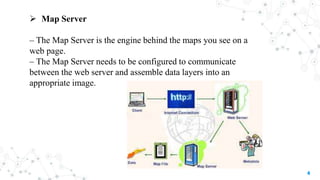
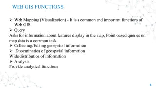
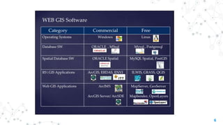
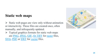
SlideShare a Scribd company logo
1 of 18
WEB GIS AND WEB MAPPING
SUBMITTED BY
ASIM PT
MSc. GEOGRAPHY
KANNUR UNIVERSITY
SUBMITTED TO
DR.BINDU KB
ASSISTANT PROFESSOR ON CONTRACT
KANNUR UNIVERSITY
WEB GIS
 Web GIS is an advanced form of Geographic Information Systems
available on web platforms.
 “Web GIS is a type of distributed information system, comprising at least a
server and a client, where the server is a GIS server and the client is a web
browser, desktop application, or mobile application. In its simplest form, web
GIS can be defined as any GIS that uses web technology to communicate
between a server and a client,( ESRI,2016)”.

2
3
 Client:
– Internet Browser such as Internet Explore, Mozila firefox etc
 Internet Connection:
– Performance of a web GIS site largely depends on the bandwidth
of the Internet connection
– Higher the bandwidth better the performance
 Web server
– Handle the requests from Web Browser (user) and Return the
web page
 Meta Data
– data about data
– Including Server URL, Owner etc
COMPONENTS OF WEB GIS
4
 Map Server
– The Map Server is the engine behind the maps you see on a
web page.
– The Map Server needs to be configured to communicate
between the web server and assemble data layers into an
appropriate image.
5
 Web Mapping (Visualization) - It is a common and important functions of
Web GIS.
 Query
Asks for information about features display in the map, Point-based queries on
map data is a common task.
 Collecting/Editing geospatial information
 Dissemination of geospatial information
Wide distribution of information
 Analysis
Provide analytical functions
WEB GIS FUNCTIONS
6
ADVANTAGE OF WEB GIS
7
 Global accessible – Web remove the constraint of distance
 A large number of user – Desktop GIS is used by only one users at a
time, while Web GIS can be used by dozens or hundreds of user
simultaneously.
 Better cross-platform capability
 Low cost as averaged by the number of users
 Makes spatial data accessible to non-technical people – User expect
Web GIS as easy as using a regular web site
 Unified Update
 Diverse application – Broad user needs drive the innovative applications
WEB MAPPING
 Web mapping is the process of designing, implementing, generating
and delivering maps on the World Wide Web.
 Web mapping provides the ability to access geospatial mapping on the
internet through a web browser interface.
 emphasizes geodata processing aspects more involved with design
aspects such as data acquisition and server software architecture such
as data storage and algorithms.
8
Types of Web Maps
Analytical web maps
 Analytical web maps offer GIS analysis.
The geodata can be a static provision, or
needs updates.
 As web clients gain capabilities processing
is distributed.
9
Animated Maps
 Animated maps show changes in the map over time by animating one of
the graphical or temporal variables. Technologies enabling client-side
display of animated web maps include scalable vector graphics (SVG),
Adobe Flash, Java, QuickTime, and others.
10
Realtime Maps
11
Realtime maps show the situation of a phenomenon in close
to realtime (only a few seconds or minutes delay).They are usually animated.
Data is collected by sensors and the maps are generated or updated at regular
intervals or on demand. Web maps with real-time animation include weather
maps, traffic congestion maps and vehicle monitoring systems.
Collaborative web maps
Collaborative maps are a developing potential. open source
collaborative software, users collaborate to create and improve the web
mapping experience.
 Some collaborative web mapping projects are:
• Google Map Maker
• Here Map Creator
• OpenStreetMap
• WikiMapia
• meta:Maps - a survey of Wikimedia movement web mapping
proposals
12
Online atlases
The traditional atlas goes through a remarkably large transition when
hosted on the web. Atlases can cease their printed editions or offer
printing on demand. Some atlases also offer raw data downloads of the
underlying geospatial data sources
13
14
Static web maps
 Static web pages are view only without animation
or interactivity. These files are created once, often
manually, and infrequently updated.
 Typical graphics formats for static web maps
are PNG, JPEG, GIF, Or TIFF for raster files,
SVG, PDF or SWF for vector files.
ADVANTAGES OF WEB MAPS
 Easy delivery of up to date
 Availability of software and hardware infrastructure at low cost
 Easy distribution of product updates
 Web maps work across browsers and operating systems
 Capability to combine distributed data sources
 Web maps allow for personalization
 Web maps enable collaborative mapping
 Web maps support hyperlinking to other information on the web
 Easy to integrate multimedia with web maps.
15
CONCLUSION
This analysis the current Web GIS architectures, and proposes a Web GIS
development process. Web GIS development processes faces new
challenges such as technology innovations, voluminous data transfer rate,
and non-specialist users. Web GIS development is more than buying GIS
software and hardware. In order to succeed, the implementation phase
must be considered as a process rather than a step. The process starts with
requirement analysis ending in web GIS use and maintenance
16
REFERENCE
 https://www.unescap.org/sites/default/files/5.%20Introduction%20t
o%20webGIS.pdf
 http://spatial.ucsb.edu/eventfiles/docs/WebGIS_Principles_and_Ap
plications_UCSB.pdf
 https://en.wikipedia.org/wiki/Web_mapping
 https://www.esri.com/arcgis-
blog/products/product/uncategorized/web-mapping-101
17
18
Thank you

More Related Content

What's hot

What's hot (20)

Introduction to GIS
Introduction to GISIntroduction to GIS
Introduction to GIS
 
Spatial data analysis 1
Spatial data analysis 1Spatial data analysis 1
Spatial data analysis 1
 
5 spatial data editing
5 spatial data editing5 spatial data editing
5 spatial data editing
 
Web GIS
Web GISWeb GIS
Web GIS
 
Introduction to GIS systems
Introduction to GIS systemsIntroduction to GIS systems
Introduction to GIS systems
 
Geodatabases
GeodatabasesGeodatabases
Geodatabases
 
Mobile gis
Mobile gisMobile gis
Mobile gis
 
Geographic Information System unit 1
Geographic Information System   unit 1Geographic Information System   unit 1
Geographic Information System unit 1
 
Application of GIS (Geographical information system)
Application of GIS (Geographical information system)Application of GIS (Geographical information system)
Application of GIS (Geographical information system)
 
Digital elevation model in GIS
Digital elevation model in GISDigital elevation model in GIS
Digital elevation model in GIS
 
Functions of GIS
Functions of GISFunctions of GIS
Functions of GIS
 
Introduction to GIS
Introduction to GISIntroduction to GIS
Introduction to GIS
 
Gis
GisGis
Gis
 
What is GIS
What is GISWhat is GIS
What is GIS
 
Gis (geographic information system)
Gis (geographic information system)Gis (geographic information system)
Gis (geographic information system)
 
What is web gis
What is web gisWhat is web gis
What is web gis
 
Introduction to gis and arc gis
Introduction to gis and arc gis Introduction to gis and arc gis
Introduction to gis and arc gis
 
GIS MAPPING
GIS MAPPINGGIS MAPPING
GIS MAPPING
 
Introduction to GIS
Introduction to GISIntroduction to GIS
Introduction to GIS
 
Coordinate systems
Coordinate systemsCoordinate systems
Coordinate systems
 

Similar to Web GIS and Mapping Overview

Web Mapping 101: What Is It and Making It Work For You
Web Mapping 101: What Is It and Making It Work For YouWeb Mapping 101: What Is It and Making It Work For You
Web Mapping 101: What Is It and Making It Work For YouSafe Software
 
Gtkwebgis third ch_one_reduced
Gtkwebgis third ch_one_reducedGtkwebgis third ch_one_reduced
Gtkwebgis third ch_one_reducedKhadijaKhan52
 
Getting your Data Out There: An Introduction to Distributed GIS
Getting your Data Out There:An Introduction to Distributed GISGetting your Data Out There:An Introduction to Distributed GIS
Getting your Data Out There: An Introduction to Distributed GISJohn Reiser
 
Web Mapping 101: What Is It and Making It Work For You
Web Mapping 101: What Is It and Making It Work For YouWeb Mapping 101: What Is It and Making It Work For You
Web Mapping 101: What Is It and Making It Work For YouSafe Software
 
iMap 4.0 Effective Management of Spatial Information
iMap 4.0 Effective Management of Spatial InformationiMap 4.0 Effective Management of Spatial Information
iMap 4.0 Effective Management of Spatial InformationEsri
 
Super map gis 8c
Super map gis 8cSuper map gis 8c
Super map gis 8cDaniel PI
 
Large Volume Map Generation via Grid Computing
Large Volume Map Generation via Grid ComputingLarge Volume Map Generation via Grid Computing
Large Volume Map Generation via Grid ComputingJeffrey Stewart
 
Dotted Eyes - Open Software, Standards and Data
Dotted Eyes - Open Software, Standards and DataDotted Eyes - Open Software, Standards and Data
Dotted Eyes - Open Software, Standards and DataDotted Eyes
 
THE OGC STANDARDS AND GEO-PLATFORM BASED WEB APPLICATION FOR SEISMIC EVENTS M...
THE OGC STANDARDS AND GEO-PLATFORM BASED WEB APPLICATION FOR SEISMIC EVENTS M...THE OGC STANDARDS AND GEO-PLATFORM BASED WEB APPLICATION FOR SEISMIC EVENTS M...
THE OGC STANDARDS AND GEO-PLATFORM BASED WEB APPLICATION FOR SEISMIC EVENTS M...Lorenzo Amato
 
Intergraph’s Server Offering_Richard Goodman - Intergraph Geospatial World To...
Intergraph’s Server Offering_Richard Goodman - Intergraph Geospatial World To...Intergraph’s Server Offering_Richard Goodman - Intergraph Geospatial World To...
Intergraph’s Server Offering_Richard Goodman - Intergraph Geospatial World To...IMGS
 
Karel charvat map-whiteboard-collaborative-map-making-breakout-session
Karel charvat map-whiteboard-collaborative-map-making-breakout-sessionKarel charvat map-whiteboard-collaborative-map-making-breakout-session
Karel charvat map-whiteboard-collaborative-map-making-breakout-sessionplan4all
 
Volume 2-issue-6-2030-2033
Volume 2-issue-6-2030-2033Volume 2-issue-6-2030-2033
Volume 2-issue-6-2030-2033Editor IJARCET
 
Volume 2-issue-6-2030-2033
Volume 2-issue-6-2030-2033Volume 2-issue-6-2030-2033
Volume 2-issue-6-2030-2033Editor IJARCET
 
NWGISS: The Web GIS Software Suite for Interoperable Access and Manipulation ...
NWGISS: The Web GIS Software Suite for Interoperable Access and Manipulation ...NWGISS: The Web GIS Software Suite for Interoperable Access and Manipulation ...
NWGISS: The Web GIS Software Suite for Interoperable Access and Manipulation ...The HDF-EOS Tools and Information Center
 
Offline maps for mobile developers (Android/iOS)
Offline maps for mobile developers (Android/iOS)Offline maps for mobile developers (Android/iOS)
Offline maps for mobile developers (Android/iOS)Vadim Nikolaev
 

Similar to Web GIS and Mapping Overview (20)

Web mapping
Web mappingWeb mapping
Web mapping
 
Web GIS using Google Map and QGIS
Web GIS using Google Map and QGISWeb GIS using Google Map and QGIS
Web GIS using Google Map and QGIS
 
Web Mapping 101: What Is It and Making It Work For You
Web Mapping 101: What Is It and Making It Work For YouWeb Mapping 101: What Is It and Making It Work For You
Web Mapping 101: What Is It and Making It Work For You
 
Gtkwebgis third ch_one_reduced
Gtkwebgis third ch_one_reducedGtkwebgis third ch_one_reduced
Gtkwebgis third ch_one_reduced
 
Getting your Data Out There: An Introduction to Distributed GIS
Getting your Data Out There:An Introduction to Distributed GISGetting your Data Out There:An Introduction to Distributed GIS
Getting your Data Out There: An Introduction to Distributed GIS
 
Web Mapping 101: What Is It and Making It Work For You
Web Mapping 101: What Is It and Making It Work For YouWeb Mapping 101: What Is It and Making It Work For You
Web Mapping 101: What Is It and Making It Work For You
 
iMap 4.0 Effective Management of Spatial Information
iMap 4.0 Effective Management of Spatial InformationiMap 4.0 Effective Management of Spatial Information
iMap 4.0 Effective Management of Spatial Information
 
Super map gis 8c
Super map gis 8cSuper map gis 8c
Super map gis 8c
 
Large Volume Map Generation via Grid Computing
Large Volume Map Generation via Grid ComputingLarge Volume Map Generation via Grid Computing
Large Volume Map Generation via Grid Computing
 
Dotted Eyes - Open Software, Standards and Data
Dotted Eyes - Open Software, Standards and DataDotted Eyes - Open Software, Standards and Data
Dotted Eyes - Open Software, Standards and Data
 
Web Based GIS
Web Based GISWeb Based GIS
Web Based GIS
 
THE OGC STANDARDS AND GEO-PLATFORM BASED WEB APPLICATION FOR SEISMIC EVENTS M...
THE OGC STANDARDS AND GEO-PLATFORM BASED WEB APPLICATION FOR SEISMIC EVENTS M...THE OGC STANDARDS AND GEO-PLATFORM BASED WEB APPLICATION FOR SEISMIC EVENTS M...
THE OGC STANDARDS AND GEO-PLATFORM BASED WEB APPLICATION FOR SEISMIC EVENTS M...
 
Intergraph’s Server Offering_Richard Goodman - Intergraph Geospatial World To...
Intergraph’s Server Offering_Richard Goodman - Intergraph Geospatial World To...Intergraph’s Server Offering_Richard Goodman - Intergraph Geospatial World To...
Intergraph’s Server Offering_Richard Goodman - Intergraph Geospatial World To...
 
Karel charvat map-whiteboard-collaborative-map-making-breakout-session
Karel charvat map-whiteboard-collaborative-map-making-breakout-sessionKarel charvat map-whiteboard-collaborative-map-making-breakout-session
Karel charvat map-whiteboard-collaborative-map-making-breakout-session
 
Volume 2-issue-6-2030-2033
Volume 2-issue-6-2030-2033Volume 2-issue-6-2030-2033
Volume 2-issue-6-2030-2033
 
Volume 2-issue-6-2030-2033
Volume 2-issue-6-2030-2033Volume 2-issue-6-2030-2033
Volume 2-issue-6-2030-2033
 
NWGISS: The Web GIS Software Suite for Interoperable Access and Manipulation ...
NWGISS: The Web GIS Software Suite for Interoperable Access and Manipulation ...NWGISS: The Web GIS Software Suite for Interoperable Access and Manipulation ...
NWGISS: The Web GIS Software Suite for Interoperable Access and Manipulation ...
 
Offline maps for mobile developers (Android/iOS)
Offline maps for mobile developers (Android/iOS)Offline maps for mobile developers (Android/iOS)
Offline maps for mobile developers (Android/iOS)
 
Geospatial Product Watch 2015
Geospatial Product Watch 2015Geospatial Product Watch 2015
Geospatial Product Watch 2015
 
Mobile gis
Mobile gisMobile gis
Mobile gis
 

Recently uploaded

Software Engineering Methodologies (overview)
Software Engineering Methodologies (overview)Software Engineering Methodologies (overview)
Software Engineering Methodologies (overview)eniolaolutunde
 
Paris 2024 Olympic Geographies - an activity
Paris 2024 Olympic Geographies - an activityParis 2024 Olympic Geographies - an activity
Paris 2024 Olympic Geographies - an activityGeoBlogs
 
A Critique of the Proposed National Education Policy Reform
A Critique of the Proposed National Education Policy ReformA Critique of the Proposed National Education Policy Reform
A Critique of the Proposed National Education Policy ReformChameera Dedduwage
 
microwave assisted reaction. General introduction
microwave assisted reaction. General introductionmicrowave assisted reaction. General introduction
microwave assisted reaction. General introductionMaksud Ahmed
 
Call Girls in Dwarka Mor Delhi Contact Us 9654467111
Call Girls in Dwarka Mor Delhi Contact Us 9654467111Call Girls in Dwarka Mor Delhi Contact Us 9654467111
Call Girls in Dwarka Mor Delhi Contact Us 9654467111Sapana Sha
 
SOCIAL AND HISTORICAL CONTEXT - LFTVD.pptx
SOCIAL AND HISTORICAL CONTEXT - LFTVD.pptxSOCIAL AND HISTORICAL CONTEXT - LFTVD.pptx
SOCIAL AND HISTORICAL CONTEXT - LFTVD.pptxiammrhaywood
 
call girls in Kamla Market (DELHI) 🔝 >༒9953330565🔝 genuine Escort Service 🔝✔️✔️
call girls in Kamla Market (DELHI) 🔝 >༒9953330565🔝 genuine Escort Service 🔝✔️✔️call girls in Kamla Market (DELHI) 🔝 >༒9953330565🔝 genuine Escort Service 🔝✔️✔️
call girls in Kamla Market (DELHI) 🔝 >༒9953330565🔝 genuine Escort Service 🔝✔️✔️9953056974 Low Rate Call Girls In Saket, Delhi NCR
 
Class 11 Legal Studies Ch-1 Concept of State .pdf
Class 11 Legal Studies Ch-1 Concept of State .pdfClass 11 Legal Studies Ch-1 Concept of State .pdf
Class 11 Legal Studies Ch-1 Concept of State .pdfakmcokerachita
 
Alper Gobel In Media Res Media Component
Alper Gobel In Media Res Media ComponentAlper Gobel In Media Res Media Component
Alper Gobel In Media Res Media ComponentInMediaRes1
 
Mastering the Unannounced Regulatory Inspection
Mastering the Unannounced Regulatory InspectionMastering the Unannounced Regulatory Inspection
Mastering the Unannounced Regulatory InspectionSafetyChain Software
 
Separation of Lanthanides/ Lanthanides and Actinides
Separation of Lanthanides/ Lanthanides and ActinidesSeparation of Lanthanides/ Lanthanides and Actinides
Separation of Lanthanides/ Lanthanides and ActinidesFatimaKhan178732
 
Interactive Powerpoint_How to Master effective communication
Interactive Powerpoint_How to Master effective communicationInteractive Powerpoint_How to Master effective communication
Interactive Powerpoint_How to Master effective communicationnomboosow
 
The basics of sentences session 2pptx copy.pptx
The basics of sentences session 2pptx copy.pptxThe basics of sentences session 2pptx copy.pptx
The basics of sentences session 2pptx copy.pptxheathfieldcps1
 
Organic Name Reactions for the students and aspirants of Chemistry12th.pptx
Organic Name Reactions  for the students and aspirants of Chemistry12th.pptxOrganic Name Reactions  for the students and aspirants of Chemistry12th.pptx
Organic Name Reactions for the students and aspirants of Chemistry12th.pptxVS Mahajan Coaching Centre
 
Presiding Officer Training module 2024 lok sabha elections
Presiding Officer Training module 2024 lok sabha electionsPresiding Officer Training module 2024 lok sabha elections
Presiding Officer Training module 2024 lok sabha electionsanshu789521
 
Presentation by Andreas Schleicher Tackling the School Absenteeism Crisis 30 ...
Presentation by Andreas Schleicher Tackling the School Absenteeism Crisis 30 ...Presentation by Andreas Schleicher Tackling the School Absenteeism Crisis 30 ...
Presentation by Andreas Schleicher Tackling the School Absenteeism Crisis 30 ...EduSkills OECD
 
POINT- BIOCHEMISTRY SEM 2 ENZYMES UNIT 5.pptx
POINT- BIOCHEMISTRY SEM 2 ENZYMES UNIT 5.pptxPOINT- BIOCHEMISTRY SEM 2 ENZYMES UNIT 5.pptx
POINT- BIOCHEMISTRY SEM 2 ENZYMES UNIT 5.pptxSayali Powar
 
Incoming and Outgoing Shipments in 1 STEP Using Odoo 17
Incoming and Outgoing Shipments in 1 STEP Using Odoo 17Incoming and Outgoing Shipments in 1 STEP Using Odoo 17
Incoming and Outgoing Shipments in 1 STEP Using Odoo 17Celine George
 

Recently uploaded (20)

9953330565 Low Rate Call Girls In Rohini Delhi NCR
9953330565 Low Rate Call Girls In Rohini  Delhi NCR9953330565 Low Rate Call Girls In Rohini  Delhi NCR
9953330565 Low Rate Call Girls In Rohini Delhi NCR
 
Software Engineering Methodologies (overview)
Software Engineering Methodologies (overview)Software Engineering Methodologies (overview)
Software Engineering Methodologies (overview)
 
Paris 2024 Olympic Geographies - an activity
Paris 2024 Olympic Geographies - an activityParis 2024 Olympic Geographies - an activity
Paris 2024 Olympic Geographies - an activity
 
A Critique of the Proposed National Education Policy Reform
A Critique of the Proposed National Education Policy ReformA Critique of the Proposed National Education Policy Reform
A Critique of the Proposed National Education Policy Reform
 
microwave assisted reaction. General introduction
microwave assisted reaction. General introductionmicrowave assisted reaction. General introduction
microwave assisted reaction. General introduction
 
Call Girls in Dwarka Mor Delhi Contact Us 9654467111
Call Girls in Dwarka Mor Delhi Contact Us 9654467111Call Girls in Dwarka Mor Delhi Contact Us 9654467111
Call Girls in Dwarka Mor Delhi Contact Us 9654467111
 
SOCIAL AND HISTORICAL CONTEXT - LFTVD.pptx
SOCIAL AND HISTORICAL CONTEXT - LFTVD.pptxSOCIAL AND HISTORICAL CONTEXT - LFTVD.pptx
SOCIAL AND HISTORICAL CONTEXT - LFTVD.pptx
 
call girls in Kamla Market (DELHI) 🔝 >༒9953330565🔝 genuine Escort Service 🔝✔️✔️
call girls in Kamla Market (DELHI) 🔝 >༒9953330565🔝 genuine Escort Service 🔝✔️✔️call girls in Kamla Market (DELHI) 🔝 >༒9953330565🔝 genuine Escort Service 🔝✔️✔️
call girls in Kamla Market (DELHI) 🔝 >༒9953330565🔝 genuine Escort Service 🔝✔️✔️
 
Class 11 Legal Studies Ch-1 Concept of State .pdf
Class 11 Legal Studies Ch-1 Concept of State .pdfClass 11 Legal Studies Ch-1 Concept of State .pdf
Class 11 Legal Studies Ch-1 Concept of State .pdf
 
Alper Gobel In Media Res Media Component
Alper Gobel In Media Res Media ComponentAlper Gobel In Media Res Media Component
Alper Gobel In Media Res Media Component
 
Mastering the Unannounced Regulatory Inspection
Mastering the Unannounced Regulatory InspectionMastering the Unannounced Regulatory Inspection
Mastering the Unannounced Regulatory Inspection
 
Separation of Lanthanides/ Lanthanides and Actinides
Separation of Lanthanides/ Lanthanides and ActinidesSeparation of Lanthanides/ Lanthanides and Actinides
Separation of Lanthanides/ Lanthanides and Actinides
 
Interactive Powerpoint_How to Master effective communication
Interactive Powerpoint_How to Master effective communicationInteractive Powerpoint_How to Master effective communication
Interactive Powerpoint_How to Master effective communication
 
The basics of sentences session 2pptx copy.pptx
The basics of sentences session 2pptx copy.pptxThe basics of sentences session 2pptx copy.pptx
The basics of sentences session 2pptx copy.pptx
 
Organic Name Reactions for the students and aspirants of Chemistry12th.pptx
Organic Name Reactions  for the students and aspirants of Chemistry12th.pptxOrganic Name Reactions  for the students and aspirants of Chemistry12th.pptx
Organic Name Reactions for the students and aspirants of Chemistry12th.pptx
 
Presiding Officer Training module 2024 lok sabha elections
Presiding Officer Training module 2024 lok sabha electionsPresiding Officer Training module 2024 lok sabha elections
Presiding Officer Training module 2024 lok sabha elections
 
Presentation by Andreas Schleicher Tackling the School Absenteeism Crisis 30 ...
Presentation by Andreas Schleicher Tackling the School Absenteeism Crisis 30 ...Presentation by Andreas Schleicher Tackling the School Absenteeism Crisis 30 ...
Presentation by Andreas Schleicher Tackling the School Absenteeism Crisis 30 ...
 
POINT- BIOCHEMISTRY SEM 2 ENZYMES UNIT 5.pptx
POINT- BIOCHEMISTRY SEM 2 ENZYMES UNIT 5.pptxPOINT- BIOCHEMISTRY SEM 2 ENZYMES UNIT 5.pptx
POINT- BIOCHEMISTRY SEM 2 ENZYMES UNIT 5.pptx
 
Código Creativo y Arte de Software | Unidad 1
Código Creativo y Arte de Software | Unidad 1Código Creativo y Arte de Software | Unidad 1
Código Creativo y Arte de Software | Unidad 1
 
Incoming and Outgoing Shipments in 1 STEP Using Odoo 17
Incoming and Outgoing Shipments in 1 STEP Using Odoo 17Incoming and Outgoing Shipments in 1 STEP Using Odoo 17
Incoming and Outgoing Shipments in 1 STEP Using Odoo 17
 

Web GIS and Mapping Overview

  • 1. WEB GIS AND WEB MAPPING SUBMITTED BY ASIM PT MSc. GEOGRAPHY KANNUR UNIVERSITY SUBMITTED TO DR.BINDU KB ASSISTANT PROFESSOR ON CONTRACT KANNUR UNIVERSITY
  • 2. WEB GIS  Web GIS is an advanced form of Geographic Information Systems available on web platforms.  “Web GIS is a type of distributed information system, comprising at least a server and a client, where the server is a GIS server and the client is a web browser, desktop application, or mobile application. In its simplest form, web GIS can be defined as any GIS that uses web technology to communicate between a server and a client,( ESRI,2016)”.  2
  • 3. 3  Client: – Internet Browser such as Internet Explore, Mozila firefox etc  Internet Connection: – Performance of a web GIS site largely depends on the bandwidth of the Internet connection – Higher the bandwidth better the performance  Web server – Handle the requests from Web Browser (user) and Return the web page  Meta Data – data about data – Including Server URL, Owner etc COMPONENTS OF WEB GIS
  • 4. 4  Map Server – The Map Server is the engine behind the maps you see on a web page. – The Map Server needs to be configured to communicate between the web server and assemble data layers into an appropriate image.
  • 5. 5  Web Mapping (Visualization) - It is a common and important functions of Web GIS.  Query Asks for information about features display in the map, Point-based queries on map data is a common task.  Collecting/Editing geospatial information  Dissemination of geospatial information Wide distribution of information  Analysis Provide analytical functions WEB GIS FUNCTIONS
  • 6. 6
  • 7. ADVANTAGE OF WEB GIS 7  Global accessible – Web remove the constraint of distance  A large number of user – Desktop GIS is used by only one users at a time, while Web GIS can be used by dozens or hundreds of user simultaneously.  Better cross-platform capability  Low cost as averaged by the number of users  Makes spatial data accessible to non-technical people – User expect Web GIS as easy as using a regular web site  Unified Update  Diverse application – Broad user needs drive the innovative applications
  • 8. WEB MAPPING  Web mapping is the process of designing, implementing, generating and delivering maps on the World Wide Web.  Web mapping provides the ability to access geospatial mapping on the internet through a web browser interface.  emphasizes geodata processing aspects more involved with design aspects such as data acquisition and server software architecture such as data storage and algorithms. 8
  • 9. Types of Web Maps Analytical web maps  Analytical web maps offer GIS analysis. The geodata can be a static provision, or needs updates.  As web clients gain capabilities processing is distributed. 9
  • 10. Animated Maps  Animated maps show changes in the map over time by animating one of the graphical or temporal variables. Technologies enabling client-side display of animated web maps include scalable vector graphics (SVG), Adobe Flash, Java, QuickTime, and others. 10
  • 11. Realtime Maps 11 Realtime maps show the situation of a phenomenon in close to realtime (only a few seconds or minutes delay).They are usually animated. Data is collected by sensors and the maps are generated or updated at regular intervals or on demand. Web maps with real-time animation include weather maps, traffic congestion maps and vehicle monitoring systems.
  • 12. Collaborative web maps Collaborative maps are a developing potential. open source collaborative software, users collaborate to create and improve the web mapping experience.  Some collaborative web mapping projects are: • Google Map Maker • Here Map Creator • OpenStreetMap • WikiMapia • meta:Maps - a survey of Wikimedia movement web mapping proposals 12
  • 13. Online atlases The traditional atlas goes through a remarkably large transition when hosted on the web. Atlases can cease their printed editions or offer printing on demand. Some atlases also offer raw data downloads of the underlying geospatial data sources 13
  • 14. 14 Static web maps  Static web pages are view only without animation or interactivity. These files are created once, often manually, and infrequently updated.  Typical graphics formats for static web maps are PNG, JPEG, GIF, Or TIFF for raster files, SVG, PDF or SWF for vector files.
  • 15. ADVANTAGES OF WEB MAPS  Easy delivery of up to date  Availability of software and hardware infrastructure at low cost  Easy distribution of product updates  Web maps work across browsers and operating systems  Capability to combine distributed data sources  Web maps allow for personalization  Web maps enable collaborative mapping  Web maps support hyperlinking to other information on the web  Easy to integrate multimedia with web maps. 15
  • 16. CONCLUSION This analysis the current Web GIS architectures, and proposes a Web GIS development process. Web GIS development processes faces new challenges such as technology innovations, voluminous data transfer rate, and non-specialist users. Web GIS development is more than buying GIS software and hardware. In order to succeed, the implementation phase must be considered as a process rather than a step. The process starts with requirement analysis ending in web GIS use and maintenance 16
  • 17. REFERENCE  https://www.unescap.org/sites/default/files/5.%20Introduction%20t o%20webGIS.pdf  http://spatial.ucsb.edu/eventfiles/docs/WebGIS_Principles_and_Ap plications_UCSB.pdf  https://en.wikipedia.org/wiki/Web_mapping  https://www.esri.com/arcgis- blog/products/product/uncategorized/web-mapping-101 17