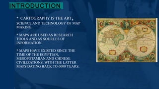
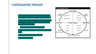
3. INTRODUCTION
* CARTOGRAPHY IS THE ART,
SCIENCE AND TECHNOLOGY OF MAP
MAKING.
* MAPS ARE USED AS RESEARCH
TOOLS AND AS SOURCES OF
INFORMATION.
* MAPS HAVE EXISTED SINCE THE
TIME OF THE EGYPTIAN,
MESOPOTAMIAN AND CHINESE
CIVILIZATIONS, WITH THE LATTER
MAPS DATING BACK TO 6000 YEARS.
4. CARTOGRAPHIC PROCESS
* The communications model of Cartography
emphasizes maps are used by variety of users
* The role of the cartographer is to understand
the subject matter of maps and also how the
map will be likely used.
• Map making involves three stages:
1 Collection, Organization and manipulation of
data.
2 Design and preparation of Maps
3 Map Reproduction
5. 1. COLLECTION, ORGANIZATION AND MANIPULATION OF DATA
* Data collection from existing maps, aerial photographs or digital imagery,
documents e.g. legal descriptions of property boundaries, historical documents,
etc., field work or questionnaire surveys.
• Data organized to understand the phenomena being represented.
• * Data manipulation - in a form suitable for map making i.e. aggregating data to
some specified set of spatial units, percentages, densities or other
summary measures.
6. 2. DESIGN AND PREPARATION OF MAP
• Many decisions go into the design of an effective map.
• * These include geographic features and thematic attributes.
• * The choices depend upon purpose of the map, the intended audience and the cartographer's
understanding of the phenomena being represented.
• * Maps of large areas it is a must to choose an appropriate map projection.
• * Small scale maps are less detailed but covers a larger area.
7. 3. MAP REPRODUCTION
• Many decisions go into the design of an effective map.
• * These include geographic features and thematic attributes.
• * The choices depend upon purpose of the map, the intended audience and the cartographer's
understanding of the phenomena being represented.
• * Maps of large areas it is a must to choose an appropriate map projection.
• * Small scale maps are less detailed but covers a larger area.
8. USES OF MAPS
• It is a learned process requiring a variety of skills.
• * Using a Map involves, three processes:
• + Map reading
• + Analysis
• + Interpretation
9. TYPES OF MAPS
• Hundreds of Maps Prepared for Various
Purposes
• × General vs. thematic cartography
• × Topographic vs. topological
10. MAP SYMBOLS
× In cartography symbols are everything.
• Cartographic symbology has been developed in an effort to portray
the world accurately and effectively convey information to the map
reader.
• * A legend explains the pictorial language of the map, known
as its symbology.
11.
12.
13. MAP PROJECTION
• Any system for transferring parallels and meridians from a globe onto a flat map
is called a projection.
• Mapmakers create projections according to mathematical formulas, often with
the aid of computers.
• × It is impossible to project a sphere, such as the earth's surface, onto a flat
surface with complete accuracy.
• * Every flat map has inaccuracies in scale that result from shrinking the globe in
some places and stretching it in others to flatten it.
14. .
• Projections by surface
• + Cylindrical+ Pseudocylindrical
• + Hybrid
• + Conic
• + Pseudoconic
• + Azimuthal (projections onto a plane)
• Projections by preservation of a metric property
• + Conformal
• + Equal-area+ Equidistant+ Gnomonic
• + Retroazimuthal
• + Compromise projections
15. + A map projection may be classified according to which properties of the
globe it distorts least.
+ Equal-area projections represent the sizes of regions in correct relation to
one another but distort shapes.
+ Conformal projections show angles and directions at any point accurately but
distort size relationships.
+ A map cannot be both equal-area and conformal, but many maps are neither.
There is no name for this third category of projections classified by distortion.
16. • A second way of classifying projections is according to the geometrical shape of the surface onto which the
projection is drawn.
• Many maps are--in theory--projections onto a cylinder, a cone, or a plane.
• Cylindrical projections are projections of the globe onto a cylinder.
Although constructed by mathematical formulas, such projections can be visualized by imagining a paper
cylinder wrapped around an illuminated globe.
• Lines from the globe would be projected onto the cylinder, which would then be slit and unrolled. The
resulting map has one or two lines that are free from distortion.
17. • The most famous cylindrical projection is the Mercator projection.
• This conformal projection is useful to navigators because a straight
line drawn between any two points on the mapprovides a route that
can be followed without changing compass direction.
• Conic projections are projections of a globe onto a cone.
• To visualize a conic projection, imagine a paper cone with its open end
resting over part of an illuminated globe.
• Lines from the globe would be projected onto the cone, which would
then be slit and unrolled.
• If the point of the cone lies directly above one of the poles, the
meridians are projected as straight lines radiating from the pole.
• The parallels appear as portions of a circle.
18. • Azimuthal projections are used most commonly to map compact areas of the earth's surface, such as the
polar regions.
• One type of azimuthal projection, called a gnomonic projection, shows the shortest distance between any
two points on the earth as a straight line.& This distance is known as a great-circle route.
• Gnomonic projections are especially useful for planning intercontinental flights.
• Other projections:
• * Several useful projections are not based on the cylinder, cone, or plane. For example, projections that are oval in shape
fall into a different category.
• * Equal-area oval projections have little distortion along the equator and along the meridian that runs through their
center.
• * Mapmakers can achieve even less distortion by splitting the oval into several arching shapes.
19. ADVANTAGES OF MAPS
• Maps are more objective and more efficient than verbal descriptions.
• A map makes it simpler to visualize and understand the spatial patterns.
• Maps can be useful sources of data and can give an historical perspective.
• Maps can be used to solve complex problems.
LIMITATION OF MAPS
• No map is ever completely accurate or complete.
• No one map can show all features present on the surface of the actual area.
• Good maps show the features that are relevant and focuses less on other features.
20. CONCLUSION
Cartography is the theory and practice
of map making and map use.
• Map is a form of communication
between the map maker and the
map user.
• As maps are synoptic they should be
carefully designed to ensure the
information is effectively conveyed.
• Earliest known maps were hand
drawn whereas the modern day
maps are digitized using high end
softwares and instruments.