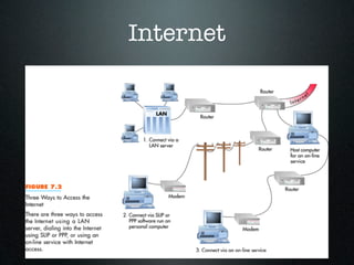
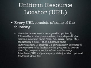
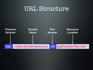
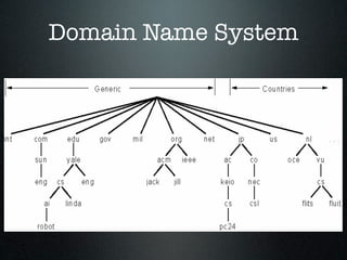
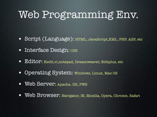
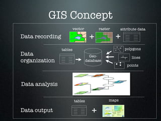
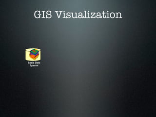
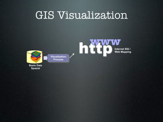
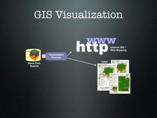
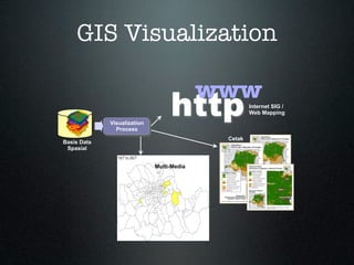
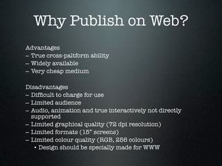
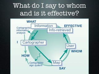
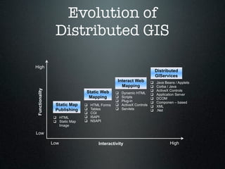
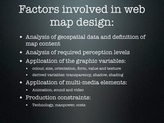
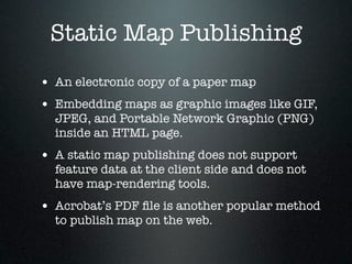
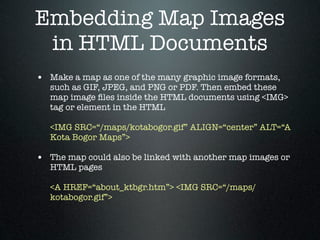
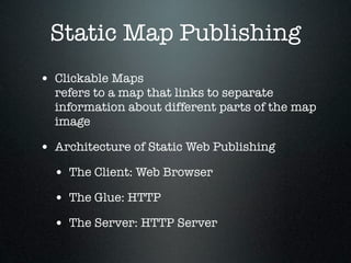
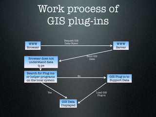
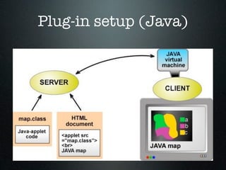
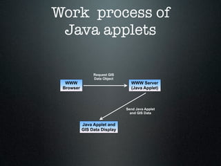
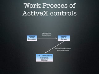
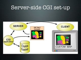
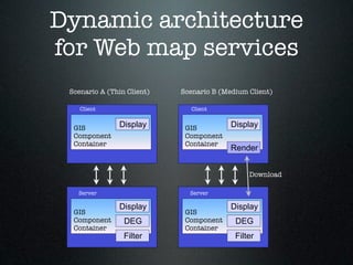
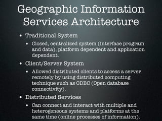
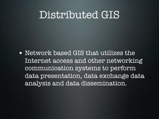
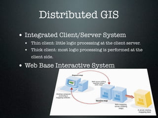
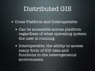
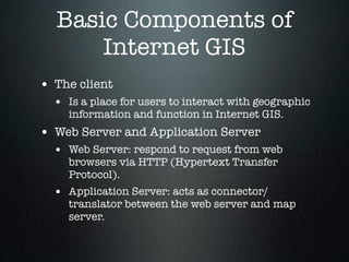
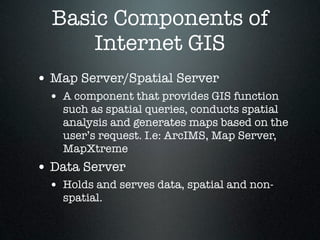
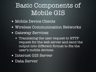
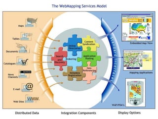
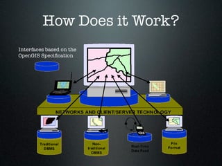
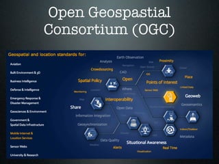
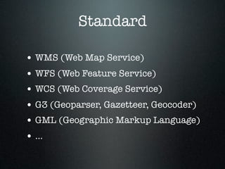
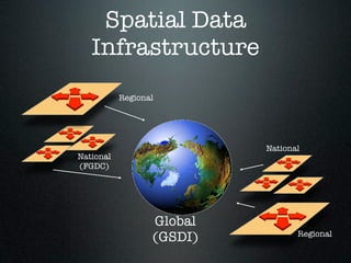
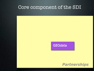
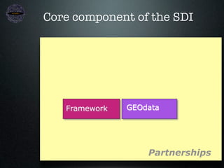
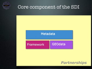
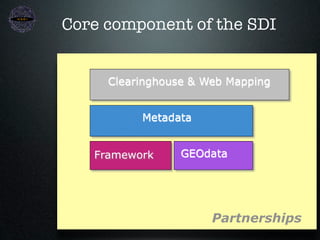
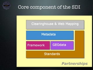
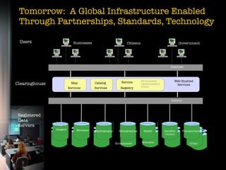
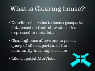
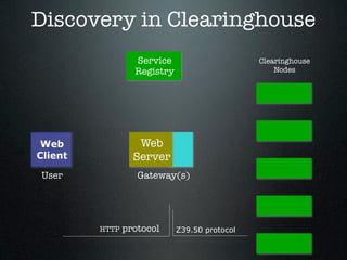
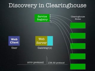
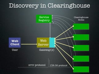
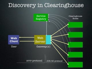
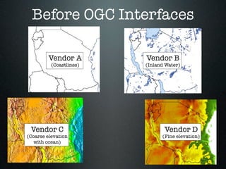
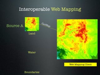
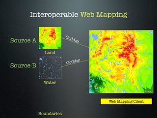
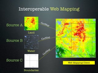
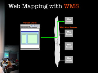
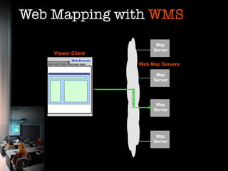
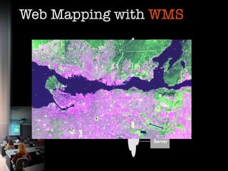
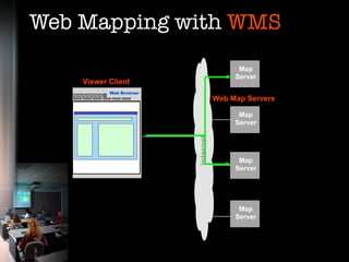
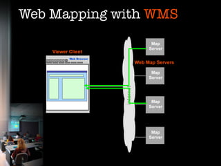
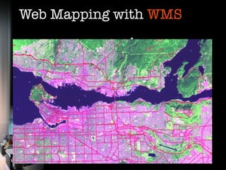
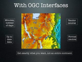
This is lecture of Advanced GIS (ITM 524), MSc in Information Technology for Natural Resources Management, Bogor Agricultural University.
This topics covered: Internet & World Wide Web, Web Mapping, Internet GIS, Web Mapping Services Model, Spatial Data Infrastructure.
Fundamentals of Remote Sensing - Introduction
What is Remote Sensing?
So, what exactly is remote sensing? For the purposes of this tutorial, we will use the following definition:
"Remote sensing is the science (and to some extent, art) of acquiring information about the Earth's surface without actually being in contact with it. This is done by sensing and recording reflected or emitted energy and processing, analyzing, and applying that information."
In much of remote sensing, the process involves an interaction between incident radiation and the targets of interest. This is exemplified by the use of imaging systems where the following seven elements are involved. Note, however that remote sensing also involves the sensing of emitted energy and the use of non-imaging sensors.
Government has huge amounts of information but how can this be effectively managed and delivered through the web? This session will ālift the lidā on web mapping technology and identify some of the key issues that must be addressed to achieve a successful outcome.
The NSW government SIX Viewer web mapping portal will be used as a case study to demonstrate how terabytes of data can be integrated and delivered via the Internet.
Data Entry and Preparation Spatial Data Input: Direct spatial data capture, Indirect spatial data captiure, Obtaining spatial data elsewhere Data Quality: Accuracy and Positioning, Positional accuracy, Attribute accuracy, Temporal accuracy, Lineage, Completeness, Logical consistency Data Preparation: Data checks and repairs, Combining data from multiple sources Point Data Transformation: Interpolating discrete data, Interpolating continuous data
When you georeference your raster data, you define its location using map coordinates and assign the coordinate system of the map frame. Georeferencing raster data allows it to be viewed, queried, and analyzed with your other geographic data. The georeferencing tools on the Georeference tab allows you to georeference any raster dataset.
In general, there are four steps to georeference your data:
Add the raster dataset that you want to align with your projected data.
Use the Georeference tab to create control points, to connect your raster to known positions in the map
Review the control points and the errors
Save the georeferencing result, when you are satisfied with the alignment.
Introduction to GIS - Basic spatial concepts - Coordinate Systems - GIS and Information Systems ā Definitions ā History of GIS - Components of a GIS ā Hardware, Software, Data, People, Methods ā Proprietary and open source Software - Types of data ā Spatial, Attribute data- types of attributes ā scales/ levels of measurements.
Free guide to develop a Web GIS
Sign up for this free minicourse to learn how professional GIS developer build a powerful Web GIS application and save thousands of dollars.
This includes a free download that will tell you the top 7 jobs skills you need for a successful career in GIS.
https://gis-science-school-mapping-your-world.teachable.com/p/free-guide-to-develop-a-web-gis-application
This is presentation is intended for middle school students. It provides a short introduction to GIS and how to use GIS in the real-world.
ArcGIS Explorer is the software used to demonstrate concepts.
45 minutes + 15 minutes demo
Download ArcGIS Explorer here...
http://www.esri.com/software/arcgis/explorer/
Talk about what relation between web and mapping. Also the process to create and collaborate on-line map using free source like mapserver, geoserver, postgis, openlayer.
Teknologi Pengelolaan dan Penyebarluasan Informasi Geospasial Berbasis Open S...Iwan Setiawan
Ā
Informasi Geospasial (IG) merupakan salah satu alat bantu dalam perumusan kebijakan, pengambilan keputusan atau pelaksanaan kegiatan. Informasi geospasial dapat digunakan dengan berbagi pakai antar stake holder untuk mendukung pembangunan, kebencanaan maupun hal lain yang membutuhkan informasi terkait kebumian.
Presentasi ini memaparkan teknologi pengelolaan dan penyebarluasan informasi geospasial berbasis open source. OpenGeo Suite dan GeoNode merupakan aplikasi berbasis open source yang dapat digunakan dalam pembangunan simpul jaringan daerah.
A lecture that I gave on 17th March 2010 at the University of Nottingham on the History of Web Mapping.
Starts with some early history and then tracks the interplay of technology, business and usage in the development of web mapping over the last 2 decades.
Based on a series of interviews with key players in the UK and US, this is a work in progress. There is still quite a lot more needed to complete this.
Some useful resources are linked to in the penultimate slide. The mind map that I used to build this talk is at http://bit.ly/HistoryWebMap
Introduction to Free and Open Source Software (FOSS)Dong Calmada
Ā
An attempt to orient the unconverted and the semi-converted on the history and benefits of Free and Open Source Software (FOSS). Created for the PANACeA FOSS training in Bangkok (Feb 2010).
Automating Crime Data to Import into GISSafe Software
Ā
Using FME, we have been able to take raw data from our records management system for Police (which is in a propriety Linux system) and be able to transform it into our ArcGIS SDE environment for online mapping applications. The crimes data does not have a coordinate system or any other spatial data associated with it except addresses- FME helps us add the spatial component to be able to use it for our web map services. With additional help from FME Server, we automated this process to run nightly and to be able to give us email notifications when the workbench succeeds or fails.
A geographic information system (GIS) is a computer system for capturing, storing, checking, and displaying data related to positions on Earth's surface. GIS can show many different kinds of data on one map. This enables people to more easily see, analyze, and understand patterns and relationships.
Anatomy of a web app
HTML5
CSS3
This presentation has been developed in the context of the Mobile Applications Development course, DISIM, University of L'Aquila (Italy), Spring 2014.
http://www.ivanomalavolta.com
A view on architectural considerations and models for the emerging context of software plus services and in view of technologies such as Windows Azure.
Slides from an HTML5 overview session I presented at work...
This presentation has an accompanying sample webapp project: http://code.google.com/p/html5-playground
Neuro-symbolic is not enough, we need neuro-*semantic*Frank van Harmelen
Ā
Neuro-symbolic (NeSy) AI is on the rise. However, simply machine learning on just any symbolic structure is not sufficient to really harvest the gains of NeSy. These will only be gained when the symbolic structures have an actual semantics. I give an operational definition of semantics as āpredictable inferenceā.
All of this illustrated with link prediction over knowledge graphs, but the argument is general.
LF Energy Webinar: Electrical Grid Modelling and Simulation Through PowSyBl -...DanBrown980551
Ā
Do you want to learn how to model and simulate an electrical network from scratch in under an hour?
Then welcome to this PowSyBl workshop, hosted by Rte, the French Transmission System Operator (TSO)!
During the webinar, you will discover the PowSyBl ecosystem as well as handle and study an electrical network through an interactive Python notebook.
PowSyBl is an open source project hosted by LF Energy, which offers a comprehensive set of features for electrical grid modelling and simulation. Among other advanced features, PowSyBl provides:
- A fully editable and extendable library for grid component modelling;
- Visualization tools to display your network;
- Grid simulation tools, such as power flows, security analyses (with or without remedial actions) and sensitivity analyses;
The framework is mostly written in Java, with a Python binding so that Python developers can access PowSyBl functionalities as well.
What you will learn during the webinar:
- For beginners: discover PowSyBl's functionalities through a quick general presentation and the notebook, without needing any expert coding skills;
- For advanced developers: master the skills to efficiently apply PowSyBl functionalities to your real-world scenarios.
Elevating Tactical DDD Patterns Through Object CalisthenicsDorra BARTAGUIZ
Ā
After immersing yourself in the blue book and its red counterpart, attending DDD-focused conferences, and applying tactical patterns, you're left with a crucial question: How do I ensure my design is effective? Tactical patterns within Domain-Driven Design (DDD) serve as guiding principles for creating clear and manageable domain models. However, achieving success with these patterns requires additional guidance. Interestingly, we've observed that a set of constraints initially designed for training purposes remarkably aligns with effective pattern implementation, offering a more āmechanicalā approach. Let's explore together how Object Calisthenics can elevate the design of your tactical DDD patterns, offering concrete help for those venturing into DDD for the first time!
Essentials of Automations: Optimizing FME Workflows with ParametersSafe Software
Ā
Are you looking to streamline your workflows and boost your projectsā efficiency? Do you find yourself searching for ways to add flexibility and control over your FME workflows? If so, youāre in the right place.
Join us for an insightful dive into the world of FME parameters, a critical element in optimizing workflow efficiency. This webinar marks the beginning of our three-part āEssentials of Automationā series. This first webinar is designed to equip you with the knowledge and skills to utilize parameters effectively: enhancing the flexibility, maintainability, and user control of your FME projects.
Hereās what youāll gain:
- Essentials of FME Parameters: Understand the pivotal role of parameters, including Reader/Writer, Transformer, User, and FME Flow categories. Discover how they are the key to unlocking automation and optimization within your workflows.
- Practical Applications in FME Form: Delve into key user parameter types including choice, connections, and file URLs. Allow users to control how a workflow runs, making your workflows more reusable. Learn to import values and deliver the best user experience for your workflows while enhancing accuracy.
- Optimization Strategies in FME Flow: Explore the creation and strategic deployment of parameters in FME Flow, including the use of deployment and geometry parameters, to maximize workflow efficiency.
- Pro Tips for Success: Gain insights on parameterizing connections and leveraging new features like Conditional Visibility for clarity and simplicity.
Weāll wrap up with a glimpse into future webinars, followed by a Q&A session to address your specific questions surrounding this topic.
Donāt miss this opportunity to elevate your FME expertise and drive your projects to new heights of efficiency.
Encryption in Microsoft 365 - ExpertsLive Netherlands 2024Albert Hoitingh
Ā
In this session I delve into the encryption technology used in Microsoft 365 and Microsoft Purview. Including the concepts of Customer Key and Double Key Encryption.
Securing your Kubernetes cluster_ a step-by-step guide to success !KatiaHIMEUR1
Ā
Today, after several years of existence, an extremely active community and an ultra-dynamic ecosystem, Kubernetes has established itself as the de facto standard in container orchestration. Thanks to a wide range of managed services, it has never been so easy to set up a ready-to-use Kubernetes cluster.
However, this ease of use means that the subject of security in Kubernetes is often left for later, or even neglected. This exposes companies to significant risks.
In this talk, I'll show you step-by-step how to secure your Kubernetes cluster for greater peace of mind and reliability.
JMeter webinar - integration with InfluxDB and GrafanaRTTS
Ā
Watch this recorded webinar about real-time monitoring of application performance. See how to integrate Apache JMeter, the open-source leader in performance testing, with InfluxDB, the open-source time-series database, and Grafana, the open-source analytics and visualization application.
In this webinar, we will review the benefits of leveraging InfluxDB and Grafana when executing load tests and demonstrate how these tools are used to visualize performance metrics.
Length: 30 minutes
Session Overviewā
-------------------------------------------
During this webinar, we will cover the following topics while demonstrating the integrations of JMeter, InfluxDB and Grafana:
- What out-of-the-box solutions are available for real-time monitoring JMeter tests?
- What are the benefits of integrating InfluxDB and Grafana into the load testing stack?
- Which features are provided by Grafana?
- Demonstration of InfluxDB and Grafana using a practice web application
To view the webinar recording, go to:
https://www.rttsweb.com/jmeter-integration-webinar
State of ICS and IoT Cyber Threat Landscape Report 2024 previewPrayukth K V
Ā
The IoT and OT threat landscape report has been prepared by the Threat Research Team at Sectrio using data from Sectrio, cyber threat intelligence farming facilities spread across over 85 cities around the world. In addition, Sectrio also runs AI-based advanced threat and payload engagement facilities that serve as sinks to attract and engage sophisticated threat actors, and newer malware including new variants and latent threats that are at an earlier stage of development.
The latest edition of the OT/ICS and IoT security Threat Landscape Report 2024 also covers:
State of global ICS asset and network exposure
Sectoral targets and attacks as well as the cost of ransom
Global APT activity, AI usage, actor and tactic profiles, and implications
Rise in volumes of AI-powered cyberattacks
Major cyber events in 2024
Malware and malicious payload trends
Cyberattack types and targets
Vulnerability exploit attempts on CVEs
Attacks on counties ā USA
Expansion of bot farms ā how, where, and why
In-depth analysis of the cyber threat landscape across North America, South America, Europe, APAC, and the Middle East
Why are attacks on smart factories rising?
Cyber risk predictions
Axis of attacks ā Europe
Systemic attacks in the Middle East
Download the full report from here:
https://sectrio.com/resources/ot-threat-landscape-reports/sectrio-releases-ot-ics-and-iot-security-threat-landscape-report-2024/
The Art of the Pitch: WordPress Relationships and SalesLaura Byrne
Ā
Clients donāt know what they donāt know. What web solutions are right for them? How does WordPress come into the picture? How do you make sure you understand scope and timeline? What do you do if sometime changes?
All these questions and more will be explored as we talk about matching clientsā needs with what your agency offers without pulling teeth or pulling your hair out. Practical tips, and strategies for successful relationship building that leads to closing the deal.
Builder.ai Founder Sachin Dev Duggal's Strategic Approach to Create an Innova...Ramesh Iyer
Ā
In today's fast-changing business world, Companies that adapt and embrace new ideas often need help to keep up with the competition. However, fostering a culture of innovation takes much work. It takes vision, leadership and willingness to take risks in the right proportion. Sachin Dev Duggal, co-founder of Builder.ai, has perfected the art of this balance, creating a company culture where creativity and growth are nurtured at each stage.
Connector Corner: Automate dynamic content and events by pushing a buttonDianaGray10
Ā
Here is something new! In our next Connector Corner webinar, we will demonstrate how you can use a single workflow to:
Create a campaign using Mailchimp with merge tags/fields
Send an interactive Slack channel message (using buttons)
Have the message received by managers and peers along with a test email for review
But thereās more:
In a second workflow supporting the same use case, youāll see:
Your campaign sent to target colleagues for approval
If the āApproveā button is clicked, a Jira/Zendesk ticket is created for the marketing design team
Butāif the āRejectā button is pushed, colleagues will be alerted via Slack message
Join us to learn more about this new, human-in-the-loop capability, brought to you by Integration Service connectors.
And...
Speakers:
Akshay Agnihotri, Product Manager
Charlie Greenberg, Host
Kubernetes & AI - Beauty and the Beast !?! @KCD Istanbul 2024Tobias Schneck
Ā
As AI technology is pushing into IT I was wondering myself, as an āinfrastructure container kubernetes guyā, how get this fancy AI technology get managed from an infrastructure operational view? Is it possible to apply our lovely cloud native principals as well? What benefitās both technologies could bring to each other?
Let me take this questions and provide you a short journey through existing deployment models and use cases for AI software. On practical examples, we discuss what cloud/on-premise strategy we may need for applying it to our own infrastructure to get it to work from an enterprise perspective. I want to give an overview about infrastructure requirements and technologies, what could be beneficial or limiting your AI use cases in an enterprise environment. An interactive Demo will give you some insides, what approaches I got already working for real.
2. Agenda:
ā¢ Internet & World Wide Web
ā¢ Web Mapping
ā¢ Internet GIS
ā¢ Web Mapping Services Model
ā¢ Spatial Data Infrastructure
3. Internet
ā¢ A global computer network providing
a variety of information and
communication facilities, consisting of
interconnected networks using
standardized communication
protocols
ā¢ Designed for US Military (http://
dir.yahoo.com/
Computers_and_internet/Internet/
History/)
4. History of Internet
ā¢ ARPANET (Advanced Research
Project Agency Network): 60ās
ā¢ UCLA, UC Santa Barbara, Stanford,
Univ. of Utah.
ā¢ Internetworking
7. Computer Network
ā¢ Stand-alone computer: A PC by itself
without connecting to other
computers
ā¢ Network: Two or more computers and
other devices connected together are
called a network.
ā¢ Networking: Concept of connected
computers sharing resources
9. World Wide Web
ā¢ A system of Internet servers that support
specially formatted documents. The
documents are formatted in a markup
language called HTML (HyperText
Markup Language) that supports links to
other documents, as well as graphics,
audio, and video ļ¬les.
10. World Wide Web
ā¢ Invented by Tim Berners Lee (1990)
ā¢ Maintained by W3C
ā¢ Document Format : HTML
ā¢ Protocol : HTTP
11. World Wide Web
ā¢ Personal/corporate
ā¢ e-Commerce, e-Government, e-
Learning, etc
ā¢ News/information/community/
corporate portal
13. HTTP
ā¢ HTTP = Hypertext Transfer Protocol
ā¢ The Web uses the HTTP protocol, only one of
the languages spoken over the Internet, to
transmit data.
ā¢ Web services, which use HTTP to allow
applications to communicate in order to
exchange business logic, use the the Web to
share
14. HTTP Request
HTTP HTTP
Web Web Server and
Browser File System
15. Web Server &
Web Browser
2. Server fetches
Client machine Server machine
document from
local ļ¬le
Browser Web server
OS
3. Response
1. Get document request
16. Uniform Resource
Locator (URL)
ā¢ Uniform (or universal) resource locator, the
address of a World Wide Web page.
ā¢ A URL is one type of Uniform Resource
Identiļ¬er (URI); the generic term for all
types of names and addresses that refer to
objects on the World Wide Web.
ā¢ Example:
ā¢ ļ¬le://ftp.serverku.co.id/umum/ļ¬les/webprog.doc
ā¢ news://news.serverku.co.id/soc.culture.indonesia
17. Uniform Resource
Locator (URL)
ā¢ Every URL consists of some of the
following:
ā¢ the scheme name (commonly called protocol),
followed by a colon, two slashes, then, depending on
scheme, a server name (exp. ftp., www., smtp., etc)
followed by a dot (.) then a domain name
(alternatively, IP address), a port number, the path of
the resource to be fetched or the program to be run,
then, for programs such as Common Gateway
Interface (CGI) scripts, a query string, and an optional
fragment identiļ¬er.
18. URL Structure
Protocol Domain Port Resource
Scheme Name Number Location
http ://www.domainname.com :80 /path/subdir/files.html
23. GIS Visualization
www
Visualization
Process
http Internet SIG /
Web Mapping
Basis Data
Spasial
24. GIS Visualization
www
Visualization
Process
http Internet SIG /
Web Mapping
Cetak
Basis Data
Spasial
25. GIS Visualization
www
Visualization
Process
http Internet SIG /
Web Mapping
Cetak
Basis Data
Spasial
Multi-Media
26. Why Publish on Web?
Advantages
ā True cross-paltform ability
ā Widely available
ā Very cheap medium
Disadvantages
ā Difļ¬cult to charge for use
ā Limited audience
ā Audio, animation and true interactively not directly
supported
ā Limited graphical quality (72 dpi resolution)
ā Limited formats (15ā screens)
ā Limited colour quality (RGB, 256 colours)
ā¢ Design should be specially made for WWW
29. Evolution of
Distributed GIS
High
Distributed
GIServices
Interact Web ļ± Java Beans / Applets
Mapping ļ± Corba / Java
Functionality
Static Web ļ± ActiveX Controls
ļ± Dynamic HTML ļ± Application Server
Mapping ļ± Scripts ļ± DCOM
ļ± Plug-in ļ± Componen ā based
Static Map ļ± HTML Forms ļ± ActiveX Controls ļ± XML
Publishing ļ± Tables ļ± Servlets ļ± .Net
ļ± CGI
ļ± HTML ļ± ISAPI
ļ± Static Map ļ± NSAPI
Image
Low
Low Interactivity High
30. Factors involved in web
map design:
ā¢ Analysis of geospatial data and deļ¬nition of
map content
ā¢ Analysis of required perception levels
ā¢ Application of the graphic variables:
ā¢ colour, size, orientation, form, value and texture
ā¢ derived variables: transparency, shadow, shading
ā¢ Application of multi-media elements:
ā¢ Animation, sound and video
ā¢ Production constraints:
ā¢ Technology, manpower, costs
31. Static Map Publishing
ā¢ An electronic copy of a paper map
ā¢ Embedding maps as graphic images like GIF,
JPEG, and Portable Network Graphic (PNG)
inside an HTML page.
ā¢ A static map publishing does not support
feature data at the client side and does not
have map-rendering tools.
ā¢ Acrobatās PDF ļ¬le is another popular method
to publish map on the web.
32. Embedding Map Images
in HTML Documents
ā¢ Make a map as one of the many graphic image formats,
such as GIF, JPEG, and PNG or PDF. Then embed these
map image ļ¬les inside the HTML documents using <IMG>
tag or element in the HTML
<IMG SRC=ā/maps/kotabogor.gifā ALIGN=ācenterā ALT=āA
Kota Bogor Mapsā>
ā¢ The map could also be linked with another map images or
HTML pages
<A HREF=āabout_ktbgr.htmā> <IMG SRC=ā/maps/
kotabogor.gifā>
33. Static Map Publishing
ā¢ Clickable Maps
refers to a map that links to separate
information about different parts of the map
image
ā¢ Architecture of Static Web Publishing
ā¢ The Client: Web Browser
ā¢ The Glue: HTTP
ā¢ The Server: HTTP Server
35. Architecture of static
map publishing
Tier1 Tier2 Tier3
Map
HTML Servers
Web Document
Browsers HTTP
HTTP DBMS
(HTML &
Forms)
CGI
Application
Servers
Web Internet Web Server
Client TCT/IP Server Applications
36. Architecture of CGI-
based Internet GIS
User Send
Request Variables
WWW Invoke
WWW CGI GIS
Server
Browser SCRIPT Server
Deliver (http) Translate Return
Results Results Result
37. Interactive Web Mapping
ā¢ More interactions between user and
the client interface and more client-
side processing and functionalities
than static web mapping applications
38. Work process of
GIS plug-ins
Request GIS
WWW Data Object WWW
Browser Server
Send GIS
Browser does not Data
understand data
type
Search for Plug-ins
or helper programs No GIS Plug-in to
on the local system Support Data
Yes Load GIS
Plug-in
GIS Data
Displayed
41. Work process of
Java applets
Request GIS
Data Object
WWW WWW Server
Browser (Java Applet)
Send Java Applet
and GIS Data
Java Applet and
GIS Data Display
42. Work Procces of
ActiveX controls
Request GIS
Data Object
WWW WWW
Browser Server
Send ActiveX Control
and Data Object
GIS Control and
GIS Data
Display
44. Dynamic architecture
for Web map services
Scenario A (Thin Client) Scenario B (Medium Client)
Client Client
GIS Display GIS Display
Component Component
Container Container
Render
Download
Server Server
Display Display
GIS GIS
Component DEG Component DEG
Container Container
Filter Filter
45. Internet GIS
ā¢ What is Internet GIS:
ā¢ Internet GIS is a research and application that
utilizes the Internet to facilitate the access,
processing and dissemination of geographic
information and spatial analysis knowledge.
ā¢ Network based GIS that utilizes the Internet to
access remote geographic information and geo-
processing tools.
ā¢ Part of Distributed GIS
46. The impact of Internet
on GIS
ā¢ GIS data access
ā¢ Provide easy access to acquire GIS data
from different data providers.
ā¢ Spatial information dissemination
ā¢ General public can directly access and
explore spatial information from their
web browser.
ā¢ GIS processing
ā¢ Conduct GIS processing and analysis (in
the future..).
47. Geographic Information
Services Architecture
ā¢ Traditional System
ā¢ Closed, centralized system (interface program
and data), platform dependent and application
dependent.
ā¢ Client/Server System
ā¢ Allowed distributed clients to access a server
remotely by using distributed computing
technique such as ODBC (Open database
connectivity).
ā¢ Distributed Services
ā¢ Can connect and interact with multiple and
heterogeneous systems and platforms at the
same time (online processes of information).
48. Distributed GIS
ā¢ Network based GIS that utilizes the
Internet access and other networking
communication systems to perform
data presentation, data exchange data
analysis and data dissemination.
49. Distributed GIS
ā¢ Integrated Client/Server System
ā¢ Thin client: little logic processing at the client server.
ā¢ Thick client: most logic processing is performed at the
client side.
ā¢ Web Base Interactive System
50. Distributed GIS
ā¢ Cross Platform and Interoperable
ā¢ Can be accessible across platform
regardless of what operating system
the user is running.
ā¢ Interoperable; the ability to access
many form of GIS data and
functions in the heterogeneous
environment.
51. Basic Components of
Internet GIS
ā¢ The client
ā¢ Is a place for users to interact with geographic
information and function in Internet GIS.
ā¢ Web Server and Application Server
ā¢ Web Server: respond to request from web
browsers via HTTP (Hypertext Transfer
Protocol).
ā¢ Application Server: acts as connector/
translator between the web server and map
server.
52. Basic Components of
Internet GIS
ā¢ Map Server/Spatial Server
ā¢ A component that provides GIS function
such as spatial queries, conducts spatial
analysis and generates maps based on the
userās request. I.e: ArcIMS, Map Server,
MapXtreme
ā¢ Data Server
ā¢ Holds and serves data, spatial and non-
spatial.
53. Basic Components of
Mobile GIS
ā¢ Mobile Device Clients
ā¢ Wireless Communication Networks
ā¢ Gateway Services
ā¢ Translating the user request to HTTP
request for the web server and send the
output into different format to ļ¬ts the
userās mobile devices.
ā¢ Internet GIS Server
ā¢ Data Server
54.
55. How Does it Work?
Interfaces based on the
OpenGIS Speciļ¬cation
63. Core component of the SDI
Clearinghouse & Web Mapping
Metadata
Framework GEOdata
Partnerships
64. Core component of the SDI
Clearinghouse & Web Mapping
Metadata
Framework GEOdata
Standards
Partnerships
65. Tomorrow: A Global Infrastructure Enabled
Through Partnerships, Standards, Technology
Users s
Businesses
s
Citizens
s
Government
Internet
Service Web-Enabled
Clearinghouse Map Catalog
Services
Services Services Registry
Internet
Registered
Data
Metadata Metadata Metadata Metadata Metadata Metadata Metadata
Servers
Imagery Elevation Hydrography Demographics Health Geodetic Transportation
Control
Environment Economic Crime
66. Tomorrow: A Global Infrastructure Enabled
Through Partnerships, Standards, Technology
Users s
Businesses
s
Citizens
s
Government
Internet
Service ā¢E-Commerce Web-Enabled
Clearinghouse Map Catalog ā¢Authentication Services
ā¢Other
Services Services Registry
Internet
Registered
Data
Metadata Metadata Metadata Metadata Metadata Metadata Metadata
Servers
Imagery Elevation Hydrography Demographics Health Geodetic Transportation
Control
Environment Economic Crime
67. Clearing house &
Metadata
ā¢ Search and Discovery via Clearinghouse
ā¢ Clearinghouse Registration
68. What is Clearing house?
ā¢ Distributed service to locate geospatial
data based on their characteristics
expressed in metadata
ā¢ Clearinghouse allows one to pose a
query of all or a portion of the
community in a single session
ā¢ Like a spatial AltaVista
69. Discovery in Clearinghouse
Service Clearinghouse
Registry Nodes
Web Web
Client Server
User Gateway(s)
HTTP protocol Z39.50 protocol
70. Discovery in Clearinghouse
Service Clearinghouse
Registry Nodes
Web Web
Client Server
User Gateway(s)
HTTP protocol Z39.50 protocol
71. Discovery in Clearinghouse
Service Clearinghouse
Registry Nodes
Web Web
Client Server
User Gateway(s)
HTTP protocol Z39.50 protocol
72. Discovery in Clearinghouse
Service Clearinghouse
Registry Nodes
Web Web
Client Server
User Gateway(s)
HTTP protocol Z39.50 protocol
73. Discovery in Clearinghouse
Service Clearinghouse
Registry Nodes
Web Web
Client Server
User Gateway(s)
HTTP protocol Z39.50 protocol
74. Discovery in Clearinghouse
Service Clearinghouse
Registry Nodes
Web Web
Client Server
User Gateway(s)
HTTP protocol Z39.50 protocol
75. Before OGC Interfaces
Vendor A Vendor B
(Coastlines) (Inland Water)
Vendor C Vendor D
(Coarse elevation (Fine elevation)
with ocean)