LiDAR 101
•
22 likes•3,828 views

Light-imaging Detection and Ranging (LiDAR) has become a common tool used in mapping and is being dispatched to complete more and more projects, but do you understand what this technology is, how it works, and what it can be used for? Through this brief but informative presentation, we’ll get you up-to-date on LiDAR technology and its ability to offer acquisition of digital elevation data for large-scale mapping projects. We’ll also discuss how LiDAR can work alongside traditional aerial photography and photogrammetric techniques – making it even more powerful.
Report
Share
Report
Share

Recommended
Introduction to GIS
GIS is a system for managing and analyzing geographic data. It uses two main data models: vector, representing points, lines and polygons; and raster, representing data as a grid of cells. Common file formats include shapefiles for vector data and GeoTIFF and MrSID for raster. GIS data is referenced using coordinate systems like WGS84 for global latitude/longitude or HK80Grid for Hong Kong. ESRI's ArcGIS software allows viewing, editing, and publishing this geospatial data for mapping and analysis.
Lidar
LIDAR is an acronym for LIght Detection And Ranging. It is an optical remote sensing technology that can measure the distance to or other properties of a target by illuminating the target with light pulse to form an image.
Introduction to WebGIS- Esri norsk BK 2014
The document summarizes a technical workshop on the ArcGIS platform and web GIS. It outlines the evolution of GIS technology towards more integrated software and services. It then reviews the key components of the ArcGIS platform, including ArcGIS Desktop, ArcGIS Online, Portal for ArcGIS, and ArcGIS Server. It demonstrates how GIS data and resources can be centralized in a portal and accessed through web apps by users on desktops, web, and mobile devices. The workshop concludes with advice on implementing web GIS within an organization.
Lidar technology and it’s applications
The document discusses LIDAR technology and its applications. It provides an introduction to LIDAR, describing how it uses lasers to measure distance. Examples of applications discussed include traffic sign detection using LIDAR and camera fusion, forestry inventory using LIDAR to measure tree characteristics, and autonomous vehicles using LIDAR for obstacle detection. The document also covers advantages of LIDAR like high accuracy, fast data collection and lower costs compared to other methods.
Introduction to arc gis
The document provides an introduction to ArcGIS. It outlines that it will discuss what GIS is, how geographic data is represented in GIS, how data is stored in ArcGIS, GIS maps, GIS analysis processes, what ArcGIS is, and planning a GIS project. It then proceeds to define GIS, explain how geographic data is modeled in vector and raster formats, describe how data is organized and stored in an ArcGIS geodatabase, discuss GIS mapping and visualization, and overview spatial analysis tools in ArcGIS.
LiDAR Data Processing and Classification
This document discusses techniques for interpreting point cloud and image data through automated algorithms that translate human visual interpretations. It describes popular approaches for processing LiDAR point clouds, including height-based segmentation to classify features above the ground and shape-fitting algorithms. It also discusses using spectral information through intensity values or image fusion. Finally, it examines developing "computer vision" tools that can segment data based on visual cues humans use like color, texture, morphology, context and defined shapes. The goal is to replicate human visual interpretation abilities through algorithms.
Lidar- light detection and ranging
LIDAR is a remote sensing method that uses light in the form of a pulsed laser to measure ranges (variable distances) to the Earth. It can be used to generate precise, three-dimensional information about the structure of objects and terrain. LIDAR involves the measurement of distance to a target by illuminating that target with laser light and measuring the reflected pulses with a sensor. Differences in laser return times and wavelengths can then be used to make digital 3D representations of the target. LIDAR originated in the 1960s and has various applications including terrain mapping, atmospheric studies, robotics, autonomous vehicles, archaeology, geology and forestry.
LIDAR
Lidar is an acronym for light detection and ranging. It is an optical remote sensing technology that can measure the distance to, or other properties of a target by illuminating the target with light, often using pulses from a laser.
What is GIS
Learn the basics about GIS with the presentation of Jaime Nieves and Ignacio Vázquez on Esri European User Conference 2011.
Lidar
Lidar (also written LIDAR, LiDAR or LADAR) is a remote sensing technology that measures distance by illuminating a target with a laser and analyzing the reflected light. Although thought by some to be an acronym of Light Detection And Ranging,[1] the term lidar was actually created as a portmanteau of "light" and "radar".[2][3] Lidar is popularly used as a technology to make high-resolution maps, with applications in geodesy, geomatics, archaeology, geography, geology, geomorphology, seismology, forestry, remote sensing, atmospheric physics,[4] airborne laser swath mapping (ALSM), laser altimetry, and contour mapping.
LiDAR
LiDAR is an active remote sensing technique that uses laser light to image objects. It was invented in the 1960s and became popular after being used on the Apollo 15 mission to map the moon's surface. LiDAR works by measuring the time it takes for a laser pulse to be reflected off an object and return, allowing it to create precise 3D models of surfaces and objects. It has numerous applications like terrain mapping, forestry, archaeology and more due to its speed, accuracy and ability to capture dense point cloud data without human involvement. While powerful lasers pose safety risks, LiDAR provides significant advantages over passive imaging and is an important remote sensing tool.
Rankin LiDAR presentation
LiDAR uses laser light to rapidly create high-resolution 3D models of objects and terrain. It has largely replaced photogrammetry for topographic mapping due to its ability to collect data day or night and its direct measurement of ground surfaces. While public LiDAR datasets are useful for planning, private firms can benefit more from terrestrial and aerial LiDAR for detailed civil engineering and surveying projects. LiDAR allows rapid mapping of complex sites and piping networks to support master planning, grading, utilities, and other design work.
Close range photogrammetry avinash
Close range photogrammetry uses terrestrial photographs taken from the earth's surface to measure objects within 300 meters. It has been used in architecture since 1885 to record buildings and monuments, reconstruct damaged structures, and determine deformations and changes. There are three types of analogue instruments used - normal case plotters, universal plotters, and mapping plotters. Cameras are classified based on the presence of fiducial marks and include metric and non-metric cameras. Stereometric camera systems from 1920-1960 were applied to fields like architecture, archaeology, and engineering but had limitations due to restricted camera choices and fixed projection angles. Close range photogrammetry provides advantages like non-contact measurement, rapid data capture, ability to measure deform
Introduction to GIS
This document provides an introduction to Geographic Information Systems (GIS). It defines GIS as a computer system for capturing, storing, manipulating, analyzing and presenting spatially-referenced data. The document discusses examples of GIS applications, the history of GIS from the 1970s to present, and its use in fields like urban planning, hydrological modeling and the water sector. It also compares open source GIS software like QGIS to proprietary software like ESRI ArcGIS, and reviews some key open source GIS tools including GDAL, Python and OSGeo4W.
Digital photogrammetry
This document discusses the history and fundamentals of digital photogrammetry. It describes the evolution from analog to digital photogrammetry and how computer hardware and software have advanced the discipline. The key aspects covered include digital image characteristics like resolution, sampling and quantization. It also outlines common image processing operations, hardware requirements, and software functions needed for digital photogrammetry like image matching, rectification and visualization.
Introduction to GIS and its Applications
GIS is a computer system for capturing, storing, analyzing and displaying geographic information. It allows users to integrate digital maps, aerial photos, satellite images and GPS data. The presentation introduces GIS components, data models, how GIS works in a 5 step process, and examples of GIS applications for 3D city modeling, traffic simulation, watershed delineation and political analysis. It also discusses the ArcGIS software suite, including ArcMap for mapping, ArcCatalog for data management and ArcToolbox for geoprocessing tools.
LiDAR Technology and Geospatial Services
An overview of Merrick's LiDAR Technology and Geospatial Services at the 4th annual SAME Technical Forum.
Resolution and scanning system
Resolution and scanning system
high resolution scanning
scanning resolution for photos
high resolution scanning service
best resolution for scanning photos
best scanning resolution for documents
scanning resolution dpi
high resolution scanning near me
What is Geography Information Systems (GIS)
GIS is a computer-based information system used to capture, manage, update, analyze, display, and output spatial data and information to be used in a decision making context. It integrates hardware, software, data, people, and allows for the visualization and analysis of data with a geographic component. Some key applications of GIS include emergency response, transportation planning, site selection, and natural resource management.
Accuracy of UAV Photogrammetry
We compared the accuracy of geospatial data derived from a RPAS and an RTK GPS
Aim: To understand the mapping applications RPAS can deployed for
Objective: By the end of this presentation the audience will be able to list the horizontal and vertical accuracies achieved by a RPAS
Check http://www.rpas.ie
Enterprise GIS
This document provides an overview of enterprise GIS system architecture design. It discusses the system design process, GIS technology, data administration, network communications, and Esri architecture. Key aspects of system performance including software, hardware, and virtualization are also covered. The document concludes with an example of using Esri's Capacity Planning Tool to help with system design.
Basic remote sensing and gis
Providing the best online coaching ,study material, guidance and solutions for CBSE UGC NET- JRF/ LS and ARS - NET in Environmental Sciences
Getting started with GIS
The basic intention of this presentation is to help the beginners in GIS to understand what GIS is? It is a simple presentation about GIS, i mean an introductory one. Hope anyone finds it useful.
Gis
Geographical Information System (GIS) is a computer system for capturing, storing, analyzing, and displaying spatially-referenced data. GIS allows users to visualize relationships and patterns in data through maps, globes, reports, and charts. The key components of GIS are data capture, database management, geographic analysis, and result preparation. GIS data comes in vector and raster formats, with vector being better for representing real-world features precisely and raster being better for dense data like elevation or land cover. GIS provides accurate data, better analysis and predictions, and helps answer questions by visualizing spatial relationships. However, GIS software can be expensive and difficult to integrate with traditional maps.
Introduction to GIS
This document provides an introduction to geographic information systems (GIS). It defines GIS as a computer system for capturing, storing, analyzing and displaying spatially-referenced data. A GIS integrates database operations with maps in digital form and allows users to create interactive queries, analyze spatial information, edit maps and present results. The document outlines key components of a GIS including data, databases, processing capabilities, hardware and communications. It also discusses the importance of location in problem-solving and decision making as well as the history and business applications of GIS technology.
Geoprocessing
This document provides an overview of geoprocessing, which allows users to define, manage, and analyze spatial information to support decision making. It discusses how geoprocessing works in ArcGIS through tools, models, scripts, and toolboxes. Specific geoprocessing tasks like overlay, proximity, surfaces, and statistics are examined. The document also covers data sources, running tools, and settings. It provides examples of creating a model and script to automate repetitive geoprocessing work.
Introduction to GIS.pptx
basic concept of geographic data,GIS and its component,data acquisition ,raster, vector formats,spatial data,topology and data model data output ,GIS applications
Introduction to gis
This document provides an introduction to Geographic Information Systems (GIS) presented by Muhammad Haris. It begins with informal definitions of GIS for beginners and discusses how GIS links spatial and attribute data to find patterns. Examples are given of how GIS represents and analyzes layered data in vector and raster formats. Major application areas of GIS are outlined such as emergency routing and 3D modeling. The presentation concludes with a discussion of common GIS software and where the technology is used.
LIDAR
LIDAR uses laser light to measure distance by illuminating a target and analyzing the reflected light. It can be used to generate highly accurate 3D models of terrain, infrastructure, and other physical features. LIDAR systems consist of a laser, scanner, photodetector, and navigation components. LIDAR has various applications in fields like geography, archaeology, environment, and autonomous vehicles due to its ability to rapidly capture precise spatial data regardless of lighting conditions.
light-detection-and-ranging(lidar)
LIDAR is a remote sensing technology that uses lasers to measure properties of scattered light. It measures the time delay between the transmitted and reflected signals to determine the distance to an object. LIDAR consists of a laser transmitter, receiver, and detector. It uses much shorter wavelengths than RADAR, allowing for higher resolution. Common applications of LIDAR include topographic mapping, atmospheric research, robotics, archaeology, geology, and astronomy.
More Related Content
What's hot
What is GIS
Learn the basics about GIS with the presentation of Jaime Nieves and Ignacio Vázquez on Esri European User Conference 2011.
Lidar
Lidar (also written LIDAR, LiDAR or LADAR) is a remote sensing technology that measures distance by illuminating a target with a laser and analyzing the reflected light. Although thought by some to be an acronym of Light Detection And Ranging,[1] the term lidar was actually created as a portmanteau of "light" and "radar".[2][3] Lidar is popularly used as a technology to make high-resolution maps, with applications in geodesy, geomatics, archaeology, geography, geology, geomorphology, seismology, forestry, remote sensing, atmospheric physics,[4] airborne laser swath mapping (ALSM), laser altimetry, and contour mapping.
LiDAR
LiDAR is an active remote sensing technique that uses laser light to image objects. It was invented in the 1960s and became popular after being used on the Apollo 15 mission to map the moon's surface. LiDAR works by measuring the time it takes for a laser pulse to be reflected off an object and return, allowing it to create precise 3D models of surfaces and objects. It has numerous applications like terrain mapping, forestry, archaeology and more due to its speed, accuracy and ability to capture dense point cloud data without human involvement. While powerful lasers pose safety risks, LiDAR provides significant advantages over passive imaging and is an important remote sensing tool.
Rankin LiDAR presentation
LiDAR uses laser light to rapidly create high-resolution 3D models of objects and terrain. It has largely replaced photogrammetry for topographic mapping due to its ability to collect data day or night and its direct measurement of ground surfaces. While public LiDAR datasets are useful for planning, private firms can benefit more from terrestrial and aerial LiDAR for detailed civil engineering and surveying projects. LiDAR allows rapid mapping of complex sites and piping networks to support master planning, grading, utilities, and other design work.
Close range photogrammetry avinash
Close range photogrammetry uses terrestrial photographs taken from the earth's surface to measure objects within 300 meters. It has been used in architecture since 1885 to record buildings and monuments, reconstruct damaged structures, and determine deformations and changes. There are three types of analogue instruments used - normal case plotters, universal plotters, and mapping plotters. Cameras are classified based on the presence of fiducial marks and include metric and non-metric cameras. Stereometric camera systems from 1920-1960 were applied to fields like architecture, archaeology, and engineering but had limitations due to restricted camera choices and fixed projection angles. Close range photogrammetry provides advantages like non-contact measurement, rapid data capture, ability to measure deform
Introduction to GIS
This document provides an introduction to Geographic Information Systems (GIS). It defines GIS as a computer system for capturing, storing, manipulating, analyzing and presenting spatially-referenced data. The document discusses examples of GIS applications, the history of GIS from the 1970s to present, and its use in fields like urban planning, hydrological modeling and the water sector. It also compares open source GIS software like QGIS to proprietary software like ESRI ArcGIS, and reviews some key open source GIS tools including GDAL, Python and OSGeo4W.
Digital photogrammetry
This document discusses the history and fundamentals of digital photogrammetry. It describes the evolution from analog to digital photogrammetry and how computer hardware and software have advanced the discipline. The key aspects covered include digital image characteristics like resolution, sampling and quantization. It also outlines common image processing operations, hardware requirements, and software functions needed for digital photogrammetry like image matching, rectification and visualization.
Introduction to GIS and its Applications
GIS is a computer system for capturing, storing, analyzing and displaying geographic information. It allows users to integrate digital maps, aerial photos, satellite images and GPS data. The presentation introduces GIS components, data models, how GIS works in a 5 step process, and examples of GIS applications for 3D city modeling, traffic simulation, watershed delineation and political analysis. It also discusses the ArcGIS software suite, including ArcMap for mapping, ArcCatalog for data management and ArcToolbox for geoprocessing tools.
LiDAR Technology and Geospatial Services
An overview of Merrick's LiDAR Technology and Geospatial Services at the 4th annual SAME Technical Forum.
Resolution and scanning system
Resolution and scanning system
high resolution scanning
scanning resolution for photos
high resolution scanning service
best resolution for scanning photos
best scanning resolution for documents
scanning resolution dpi
high resolution scanning near me
What is Geography Information Systems (GIS)
GIS is a computer-based information system used to capture, manage, update, analyze, display, and output spatial data and information to be used in a decision making context. It integrates hardware, software, data, people, and allows for the visualization and analysis of data with a geographic component. Some key applications of GIS include emergency response, transportation planning, site selection, and natural resource management.
Accuracy of UAV Photogrammetry
We compared the accuracy of geospatial data derived from a RPAS and an RTK GPS
Aim: To understand the mapping applications RPAS can deployed for
Objective: By the end of this presentation the audience will be able to list the horizontal and vertical accuracies achieved by a RPAS
Check http://www.rpas.ie
Enterprise GIS
This document provides an overview of enterprise GIS system architecture design. It discusses the system design process, GIS technology, data administration, network communications, and Esri architecture. Key aspects of system performance including software, hardware, and virtualization are also covered. The document concludes with an example of using Esri's Capacity Planning Tool to help with system design.
Basic remote sensing and gis
Providing the best online coaching ,study material, guidance and solutions for CBSE UGC NET- JRF/ LS and ARS - NET in Environmental Sciences
Getting started with GIS
The basic intention of this presentation is to help the beginners in GIS to understand what GIS is? It is a simple presentation about GIS, i mean an introductory one. Hope anyone finds it useful.
Gis
Geographical Information System (GIS) is a computer system for capturing, storing, analyzing, and displaying spatially-referenced data. GIS allows users to visualize relationships and patterns in data through maps, globes, reports, and charts. The key components of GIS are data capture, database management, geographic analysis, and result preparation. GIS data comes in vector and raster formats, with vector being better for representing real-world features precisely and raster being better for dense data like elevation or land cover. GIS provides accurate data, better analysis and predictions, and helps answer questions by visualizing spatial relationships. However, GIS software can be expensive and difficult to integrate with traditional maps.
Introduction to GIS
This document provides an introduction to geographic information systems (GIS). It defines GIS as a computer system for capturing, storing, analyzing and displaying spatially-referenced data. A GIS integrates database operations with maps in digital form and allows users to create interactive queries, analyze spatial information, edit maps and present results. The document outlines key components of a GIS including data, databases, processing capabilities, hardware and communications. It also discusses the importance of location in problem-solving and decision making as well as the history and business applications of GIS technology.
Geoprocessing
This document provides an overview of geoprocessing, which allows users to define, manage, and analyze spatial information to support decision making. It discusses how geoprocessing works in ArcGIS through tools, models, scripts, and toolboxes. Specific geoprocessing tasks like overlay, proximity, surfaces, and statistics are examined. The document also covers data sources, running tools, and settings. It provides examples of creating a model and script to automate repetitive geoprocessing work.
Introduction to GIS.pptx
basic concept of geographic data,GIS and its component,data acquisition ,raster, vector formats,spatial data,topology and data model data output ,GIS applications
Introduction to gis
This document provides an introduction to Geographic Information Systems (GIS) presented by Muhammad Haris. It begins with informal definitions of GIS for beginners and discusses how GIS links spatial and attribute data to find patterns. Examples are given of how GIS represents and analyzes layered data in vector and raster formats. Major application areas of GIS are outlined such as emergency routing and 3D modeling. The presentation concludes with a discussion of common GIS software and where the technology is used.
What's hot (20)
Viewers also liked
LIDAR
LIDAR uses laser light to measure distance by illuminating a target and analyzing the reflected light. It can be used to generate highly accurate 3D models of terrain, infrastructure, and other physical features. LIDAR systems consist of a laser, scanner, photodetector, and navigation components. LIDAR has various applications in fields like geography, archaeology, environment, and autonomous vehicles due to its ability to rapidly capture precise spatial data regardless of lighting conditions.
light-detection-and-ranging(lidar)
LIDAR is a remote sensing technology that uses lasers to measure properties of scattered light. It measures the time delay between the transmitted and reflected signals to determine the distance to an object. LIDAR consists of a laser transmitter, receiver, and detector. It uses much shorter wavelengths than RADAR, allowing for higher resolution. Common applications of LIDAR include topographic mapping, atmospheric research, robotics, archaeology, geology, and astronomy.
LIDAR
LIDAR uses pulsed laser light to measure distance by illuminating targets and analyzing reflections. It can be used to create high-resolution 3D maps of physical features and is useful for applications in fields like agriculture, biology, engineering and law enforcement. LIDAR offers advantages over other mapping methods like higher accuracy, faster data collection and greater data density.
LIDAR
This document provides an introduction to LIDAR (Light Detection and Ranging) technology. It describes LIDAR as a remote sensing method that uses lasers to measure properties of scattered light to find range and other information of objects, similar to radar but using optical pulses. The document outlines the basic components, working principles, history and applications of LIDAR systems. It explains how LIDAR can be used for tasks like mapping terrain, monitoring forests and crops, surveying archaeological sites, and studying the atmosphere.
"Why LiDAR?" Presentation
LiDAR is a remote sensing method that uses light in the form of a pulsed laser to measure variable distances to the Earth. It can be used to create high resolution digital elevation models and terrain models. The document discusses the benefits of high resolution LiDAR data, including more accurate terrain data, multiple applications, and a return on investment of $4-5 for every $1 spent on LiDAR collection. It also provides examples of government agencies that regularly collect and update LiDAR data.
LiDAR Market is Expected to Reach $921.2 Million by 2022 - Allied Market Rese...
LiDAR Market is Expected to Reach $921.2 Million by 2022 - Allied Market Rese...Allied Market Research
Light detection and ranging (LIDAR), is a dynamically emerging technology, which helps to capture high definition 3D data of geospatial surfaces. At present, North America dominates the market in terms of spending on LiDAR solutions, followed by Europe. Increasing demand from end-users and innovations in the laser technology are projected to accelerate the market growth. These systems are most widely used in areas of defence & aerospace, civil engineering, archaeology, forestry and agriculture, mining, and transportation. Flood mapping and power line deployments are major applications of LIDAR systems in Civil engineering and forestry sectors.
The changing demands and preferences of urban population are unveiling newer LIDAR applications apart from conventional military applications. Automobile and Internet of things (IoT) would emerge as lucrative areas for investments. Driverless cars are the strategically addressed application by some of the tech-leaders, which are based on LiDAR technology. With the launch of Google cars, Apple initiated its project of developing automated cars. Such projects are expected to generate additional demand for LiDAR devices after their commercial success. Another important application that may drive the LiDAR market is smart appliances in smart homes or offices. The smart appliances based on robotics depend on LiDAR technology for their operation.
Companies need to address the rapidly changing technological needs to excel in the market. Collaborations or acquisitions are key strategies for growth of the market in the long run, as the in-house capacity building would be difficult for some of the players that are novice in the market. In addition, prominent players are introducing efficient LiDAR systems in order to target emerging markets of Asia-Pacific and LAMEA region. This is anticipated to create huge growth opportunities for leading players operating in the market.Dtv
Este documento explica el cambio de la televisión analógica a la televisión digital en los Estados Unidos, incluyendo las opciones disponibles para los espectadores, como cajas convertidoras y cupones del gobierno. También describe cómo conectar una caja convertidora a una antena y televisor, usando cables coaxiales y RCA.
New tools for LiDAR, forestry, river management and hydro-geomorphology in gvSIG
Presentation given at the gvSIG conference 2015 about the integration of the jgrasstools libraries in gvSIG.
Cctv camera
This document discusses CCTV camera technologies. It provides an overview of the history and development of CCTV, from its origins in World War II to modern applications. It then describes key features of modern CCTV cameras, including dome housings, resolution capabilities, infrared technology, analytics software, analog vs. digital formats, and Power over Ethernet. The document concludes by profiling representative camera systems from leading manufacturers like Axis, Bosch, and DVTel.
Lidar
Lidar is an optical remote sensing technology that uses light (often from a pulsed laser) to measure distance. It works by illuminating a target with a laser and analyzing the reflected light. Common components of a lidar system include a laser, scanner/optics, photodetector, and receiver electronics. Lidar has advantages over radar like faster lock-on time and narrower beam spread. Applications include agriculture, mapping, oil/gas exploration, engineering, autonomous vehicles, and atmospheric sensing from aircraft or satellites. Recent advances include lidar speed guns, Google's driverless car which uses lidar for navigation, and autonomous cruise control systems using lidar.
Avionics sai
This document discusses avionics systems used in aircraft. It states that avionics systems are dependent on electronics and account for a significant portion of an aircraft's total cost, ranging from 30% to over 75% depending on the aircraft type. The key roles of avionics systems are to enable safe and efficient mission accomplishment for military aircraft and air traffic control and all-weather operation for civil aircraft. Important considerations in avionics system design include increased safety, reliability, maintainability, and reduction in life cycle costs. The document outlines various avionics components, subsystems, architectures, and display technologies used in aircraft.
Skala, resolusi, akurasi horisontal, akurasi vertikal
skala, resolusi spasial, akurasi horisontal/circular error, vertical/linear error
Makalah agama tentang akidah dan awal mula permusuhan manusia dengan iblis
Makalah ini membahas tentang tradisi budaya kuda lumping di Desa Purbalingga dan pandangan Islam serta skenario drama permusuhan manusia dengan iblis. Tradisi kuda lumping adalah kesenian rakyat tradisional Jawa yang menampilkan tari, musik, dan nilai-nilai religius. Menurut pandangan Islam, kesenian ini dapat digunakan untuk dakwah sementara kesurupan yang terjadi bukan karena kesenian itu sendiri. Skenario drama permusu
Pengenalan alat total station (digital theodolite)
Total station adalah alat ukur sudut dan jarak yang terintegrasi dalam satu unit, mampu menghitung koordinat secara langsung. Tahapan kerjanya meliputi penempatan statif di atas titik, pengaturan nivelmen dan centering untuk mengarahkan pembidik ke titik sasaran, serta pengukuran dan penyimpanan data koordinat untuk pengolahan selanjutnya.
Nur
Makalah ini membahas sejarah pembaharuan dalam Islam, mulai dari definisi pembaharuan, pemikiran Islam sebelum periode modern, hingga pemikiran Islam modern di Mesir, Turki, dan India-Pakistan. Beberapa tokoh pemikir dan reformis utama dalam periode modern dijelaskan seperti Muhammad Ali Pasya di Mesir dan Sultan Mahmud II di Turki.
Close Circuit Television (CCTV SURVEILLANCE SYSTEMS)
Closed Circuit Television (CCTV) system allows you to monitor your office, factory or quarters etc. in order to safe gaurd your necessary assets without physically creature gift at each location. A single visual unit can display videos from mulitple surveillance cameras installed across various locations of single premises. CCTV solutions in India, specially Ahmedabad, Gujarat are getting sticking together of importance due to the ongoing efforts of organizations to efficiently monitor visitors, employees and sections of a premise that are not easily accessible. Corporate Services provides CCTV security surveillance solutions for businesses to cater to their monitoring requirements. Solutions are tailor-made based coarsely individual requirements depending vis--vis factors specific to the client’s needs and necessities.
Spatial tools for LiDAR based watershed management and forestry analysis
Open Source Spatial Tools for the analysis of LiDAR data mainly dedicated to environmental studies, watershed management and vegetation analysis
Lifi ppt
This document provides an overview of Li-Fi technology presented by Koteshwar Rao M. It defines Li-Fi as using LED light bulbs to transmit data by varying the intensity of light faster than the human eye can detect. Li-Fi uses visible light spectrum for communication. It has advantages over Wi-Fi such as higher speed, more bandwidth, more secure connections, and energy efficiency. Potential applications of Li-Fi include use in airlines, power plants, underwater environments, and converting every light bulb into an internet hotspot. Further enhancements may enable speeds over 10Gb/s.
digital tv DTMB
The document discusses digital television terrestrial broadcasting standards, focusing on DTMB (Digital Terrestrial Multimedia Broadcast), the standard used in China. DTMB uses Time-domain Synchronous Orthogonal Frequency Division Multiplexing and supports various modulation schemes and frame structures. Field trials showed DTMB provided better picture and sound quality compared to analog transmission under different reception conditions. Hong Kong began official DTV broadcasting using DTMB in 2007.
Viewers also liked (20)
LiDAR Market is Expected to Reach $921.2 Million by 2022 - Allied Market Rese...
LiDAR Market is Expected to Reach $921.2 Million by 2022 - Allied Market Rese...
New tools for LiDAR, forestry, river management and hydro-geomorphology in gvSIG
New tools for LiDAR, forestry, river management and hydro-geomorphology in gvSIG
Skala, resolusi, akurasi horisontal, akurasi vertikal
Skala, resolusi, akurasi horisontal, akurasi vertikal
Makalah agama tentang akidah dan awal mula permusuhan manusia dengan iblis
Makalah agama tentang akidah dan awal mula permusuhan manusia dengan iblis
Pengenalan alat total station (digital theodolite)
Pengenalan alat total station (digital theodolite)
Close Circuit Television (CCTV SURVEILLANCE SYSTEMS)
Close Circuit Television (CCTV SURVEILLANCE SYSTEMS)
Spatial tools for LiDAR based watershed management and forestry analysis
Spatial tools for LiDAR based watershed management and forestry analysis
Similar to LiDAR 101
LiDAR Aided Decision Making
The document discusses the use of LiDAR (light detection and ranging) technology for various applications such as flood plain mapping, transportation infrastructure, forestry management, and more. It provides details on LiDAR accuracy standards, processing methods, and deliverable data formats. The presentation aims to help audiences understand how LiDAR data can aid in decision-making processes.
Friedrich - LiDAR CADD Engr. Design
This document discusses the use of LiDAR and CAD tools in NRCS engineering designs. It outlines the NRCS software options for surface modeling, reservoir design, and waterway design. It also describes the LiDAR data collection process, preparing the data for CAD, and using it to create surfaces, determine pond volumes, and design embankments and waterways. Implementation involves using GPS networks for control and ground truthing.
Meeting LARAIC
This document summarizes a presentation on lidar data workflows. It discusses challenges with traditional project-based lidar data collection and analysis workflows. These include issues with huge data volumes, multiple data sources and formats, and lack of long-term accessibility. The presentation outlines improved workflows that integrate data collection, management, analysis and sharing. Case studies from North Carolina and Oregon demonstrate how detailed lidar data supports applications in emergency management like flood mapping and tsunami inundation modeling. New developments in automated feature extraction from lidar point clouds are also discussed. Resources for lidar data processing tools and training from Esri are provided.
Light Detection and Ranging Technology for Energy Sector
The advancement of technologies in the last decade is no surprise to anyone. LiDAR although new to some has been around for some time, haven’t heard of it? What are you missing?
This presentation will briefly explain what LiDAR is and how it is gathered, but the primary focus will be on how the Energy Sector can benefit from its use. We will show several example project datasets, tools developed and available to industry, and how this growing technology can change how you look at your projects.
Additionally, we will show how involving all members of your exploration team in a LiDAR planning process will save time and money while increasing safety and reducing environmental impact. Your well location may begin with Geology calculating back to a surface location, but the finial location can affect many other decisions your company may make…good planning makes for good decisions.
Chris Martin is a Survey Technologist with 17 years of experience in the surveying profession. His field survey career has involved major projects with TransCanada Pipelines and Alliance Pipelines along with many conventional oil and gas programs. For the last 4 years he has primarily focussed on business development and is currently a Marketing Representative for Can-Am Geomatics.
Unmanned Aerial Systems for Precision Mapping
Presentation by Renee Walmsley, Remote Sensing Program Manager at Tetra Tech, for the August 16, 2017 Rocky Mountain UAS Professionals Meetup at the Esri Broomfield office.
LiDAR Introduction @ #DataWeekend
This document introduces LiDAR (light detection and ranging) technology and its applications. It discusses how LiDAR can be used on different platforms like ground, vehicles, ships, UAVs and aircraft to generate high-resolution digital terrain models (DTMs) and dense point clouds. Airborne LiDAR provides accurate elevation data that can penetrate vegetation. The document compares discrete return and full waveform LiDAR systems and their advantages. It also introduces LIDAR Technology Co. Ltd. and its earth observation, geo-information, and location-based services using remote sensing technologies.
2012 Workshop, Introduction to LiDAR Workshop, Bruce Adey and Mark Stucky (Me...
The document provides an introduction to LiDAR technology and applications presented by GIS in the Rockies. It includes bios of the two presenters, an overview of the company Merrick & Company, and an agenda for the workshop covering LiDAR technology review, applications, data processing workflow, project planning, and Q&A. The workshop aims to educate attendees on airborne LiDAR data acquisition projects through a practical review of technical requirements and benefits of the technology.
Writing Successful GIS RFPs (2010)
The document provides information and best practices for writing a successful GIS RFP (request for proposal). It defines RFI, RFQ, and RFP, and discusses the differences. It recommends clearly defining needs and requirements, considering qualifications over cost, and providing detailed technical specifications for deliverables.
Earth Eye Statement of Qualifications
Earth Eye, LLC provides aerial and mobile LiDAR solutions using their Leica ALS 60 airborne laser scanner. They collect aerial photography, mobile right-of-way imagery, pavement imagery, and mobile LiDAR data for terrain modeling, contour generation, and transmission line inspections. Their LiDAR systems provide highly accurate data from multiple returns with vertical accuracy of less than 10 centimeters.
Soumyadip_Chandra
Soumyadip Chandra is seeking a challenging position where he can contribute his skills in LiDAR data processing and 3D modeling. He has over 5 years of experience leading LiDAR projects involving feature extraction, 3D modeling, and data classification. He has expertise in software such as Microstation, Terrascan, and ArcGIS. Chandra holds an M.Tech in Geomatics from IIT Kanpur and has published papers on remote sensing and hyperspectral data analysis.
Sun Geomatics
Sun Geomatics is a geospatial services company based in India that provides aerial and terrestrial lidar scanning, photogrammetry, GIS, and BIM services. Their mission is to provide world-class geospatial solutions meeting international standards. They serve industries such as transportation, utilities, mining, and land use. Services include aerial lidar scanning, UAV imagery processing, orthophoto production, GIS services, mobile lidar scanning, and BIM modeling. The company aims to deliver high-quality services quickly using innovative technology solutions.
McKim Creed
McKim & Creed is a full-service geomatics firm that offers a wide range of surveying and mapping services using the latest technologies. They have over 220 staff including 40 licensed surveyors across 21 states. Services include conventional surveying, 3D laser scanning, mobile scanning, subsurface utility engineering, transportation surveying, unmanned aerial systems, and airborne remote sensing using aircraft and LiDAR sensors. McKim & Creed has extensive experience with a variety of public and private clients on large infrastructure projects across multiple states.
Unmanned aerial vehicles UAVs for the Construction Industry
The potential for using UAVs within the construction and civil engineering industry is significant yet their use is currently relatively limited. The main reason behind this is a lack of awareness of their potential and the range of benefits that they can bring, even though, right through from planning to final construction, nearly every stage of the engineering process can benefit from the use of a UAV.
Hawaii Pacific GIS Conference 2012: LiDAR for Intrastructure and Terrian Mapp...
Hawaii Pacific GIS Conference 2012: LiDAR for Intrastructure and Terrian Mapp...Hawaii Geographic Information Coordinating Council
This document discusses the use of LiDAR data in disaster management. It covers acquiring LiDAR point data through traditional airborne capture or pixel correlation from imagery, with pros and cons of each. It also addresses managing and delivering LiDAR data, and exploiting the data for disaster prevention, search and rescue, insurance assessment, and restoration. Tools for classifying, visualizing, analyzing changes in LiDAR point clouds are also presented.Ni week 2018 DMC presentation IoT
The document summarizes an IoT session that provides practical advice for acquiring and using IoT data. It discusses common IoT applications that DMC has implemented including windmill monitoring, fish barrier monitoring, and fleet tracking. It covers challenges like connectivity, field deployments, data transfers, and cloud architectures. It provides solutions and recommendations for choosing hardware, connectivity protocols, cloud platforms, and addressing issues like status broadcasts, diagnostics logging, and synchronization.
Earth Eye Capabilities - Utilities
Earth Eye, LLC is a subsidiary of Data Transfer Solutions, LLC based in Orlando, FL that focuses on delivering highly accurate LiDAR solutions from aerial and mobile platforms. They provide aerial and mobile LiDAR scanning as well as aerial photography using a Leica ALS60 laser scanner with capabilities including 200,000 points per second collection rate, 100 scans per second, and up to 5 returns per pulse. Their services include vegetation management, 3D modeling, and transmission line data collection from altitudes up to 1,000 meters with vertical accuracy of 0.1 meter or less.
TechBrief_LIDARvsUAV_050416_FNL
UAV and LIDAR surveys were conducted of a 5-acre site to compare elevation measurements. The UAV survey had a vertical RMSE of 7 cm and captured 271 images at 60m altitude. The LIDAR data had a resolution of 1m and vertical RMSE of 8cm after correction. Comparisons showed the UAV and LIDAR elevations varied by less than 10cm at control points and had a 90% correlation at 100 verification points, demonstrating the surveys produced comparable results.
2018 GIS Colorado: Your Geospatial Connection: ZDV 3D A Modern 3D Visualizati...
Air traffic control (ATC) manages complex three dimensional airspace. In particular, Denver Air Route Traffic Control Center (Denver Center) is responsible for a 60,000-ft. tall volume of airspace covering over 265,000 square miles! Denver Center needs a modern 3D GIS platform capable of depicting its numerous aeronautical features including ATC areas, sectors, minimum safe altitudes, airways, military airspace, airports, navigation equipment, communication information, and surveillance infrastructure. The main objective of this study is to incorporate these entities into a 3D digital twin of Denver Center, titled ZDV-3D. ZDV-3D intends to produce intuitive mediums for visualizing and analyzing ATC system interrelationships. Esri technology applications will be incorporated including ArcGIS Pro, ArcGIS Online, and ArcGIS Earth. I will review capabilities and limitations of Denver Center’s current geospatial tools and highlight benefits of implementing the latest ArcGIS 3D rendering capabilities into this project. I will also address production challenges, plans for further ZDV-3D development, and ways to share outcomes with other ATC facilities. ZDV-3D will enable Denver Center to provide optimized efficiency and safety for all who fly in our increasingly crowded skies.
UAS Applications for Civil Engineering
Presentation provided by Mary Wohnrade, Brendan Thompson and Don Schoen of Wohnrade Civil Engineers at the October 26, 2016 Rocky Mountain UAS Professionals Meetup group.
Mobile LiDAR Data Collection
This document discusses the use of mobile LiDAR data collection, or mobile mapping (MoDaC), for surveying applications. It provides an overview of how mobile mapping works using dual 3D laser scanners, GPS units, and cameras mounted on a vehicle. The document outlines how mobile mapping can be used to efficiently collect comprehensive 3D data for transportation and infrastructure projects. It also discusses challenges around managing large mobile mapping datasets and HNTB's solution using Oracle Spatial, Amazon EC2 cloud storage, and a Silverlight interface.
Similar to LiDAR 101 (20)
Light Detection and Ranging Technology for Energy Sector
Light Detection and Ranging Technology for Energy Sector
2012 Workshop, Introduction to LiDAR Workshop, Bruce Adey and Mark Stucky (Me...
2012 Workshop, Introduction to LiDAR Workshop, Bruce Adey and Mark Stucky (Me...
Unmanned aerial vehicles UAVs for the Construction Industry
Unmanned aerial vehicles UAVs for the Construction Industry
Hawaii Pacific GIS Conference 2012: LiDAR for Intrastructure and Terrian Mapp...
Hawaii Pacific GIS Conference 2012: LiDAR for Intrastructure and Terrian Mapp...
2018 GIS Colorado: Your Geospatial Connection: ZDV 3D A Modern 3D Visualizati...
2018 GIS Colorado: Your Geospatial Connection: ZDV 3D A Modern 3D Visualizati...
More from Aerial Services
“Webmapping Solutions: Technology & Tips” -- November 13, 2013
This document provides an overview of different open source GIS software options and frameworks for developing web mapping applications. It lists popular mapping libraries, servers, data formats, and databases that can be combined to build mapping solutions. It also includes links to documentation, tutorials, and communities for open source GIS tools and web mapping.
The Rise of the Machines - ASPRS Fall 2013 - Presented by Mike Tully
What will the future of remote sensing and geospatial activities look like after unmanned aerial vehicles are fully integrated into national airspace and allowed for commercially across the country? In this informative session, Aerial Services' Mike Tully will explore what markets, businesses, and new opportunities may look like in the future. UAV/UAS promises to be "disruptive" technology and may turn many existing business models on their heads. We'll explore these topics and consider the effects to remote sensing and geospatial in the future.
Color-Infrared Aerial Imagery 101
Presented Thursday, September 3, 2009 10:00AM-11:00AM CDT (Webinar)
Mike Tully, President & CEO
Aerial Services, Inc.
Iowa Orthoimagery & LiDAR Projects + Mapping Accuracy & QA/QC
The document provides a status update on the delivery of 2009 statewide orthoimagery for 41 southwest counties in a state. As of October 27, 2009, 100% of the uncompressed GeoTIFF orthoimagery and 50% of the compressed MrSID orthoimagery had been delivered. The document also shows a map of the state with light blue and tan colors indicating availability of LiDAR data, with some areas not yet flown.
E-Docs Asset GIS
Geographic information systems (GIS) are great for capturing, storing, analyzing, and managing data and
associated attributes of spatially referenced points on earth. In the strictest sense, GIS displays only geographical
information. But have you ever considered other information being included? How about documents and assets
– they have locations on earth. We can understand a wealth of information by adding spatial components.
Aerial Services, Inc
Aerial Services, Inc. (ASI) is an integrated team of professionals providing premier services and products to government, utilities, engineers, and other geospatial customers. Based in the Iowa heartland for over 40 years, Aerial Services’ Midwestern work ethic, cutting-edge technology, and experienced staff combine to harness the power of geographic information and provide solutions you need.
More from Aerial Services (6)
“Webmapping Solutions: Technology & Tips” -- November 13, 2013
“Webmapping Solutions: Technology & Tips” -- November 13, 2013
The Rise of the Machines - ASPRS Fall 2013 - Presented by Mike Tully
The Rise of the Machines - ASPRS Fall 2013 - Presented by Mike Tully
Iowa Orthoimagery & LiDAR Projects + Mapping Accuracy & QA/QC
Iowa Orthoimagery & LiDAR Projects + Mapping Accuracy & QA/QC
Recently uploaded
20240605 QFM017 Machine Intelligence Reading List May 2024
Everything I found interesting about machines behaving intelligently during May 2024
Microsoft - Power Platform_G.Aspiotis.pdf
Revolutionizing Application Development
with AI-powered low-code, presentation by George Aspiotis, Sr. Partner Development Manager, Microsoft
HCL Notes and Domino License Cost Reduction in the World of DLAU
Webinar Recording: https://www.panagenda.com/webinars/hcl-notes-and-domino-license-cost-reduction-in-the-world-of-dlau/
The introduction of DLAU and the CCB & CCX licensing model caused quite a stir in the HCL community. As a Notes and Domino customer, you may have faced challenges with unexpected user counts and license costs. You probably have questions on how this new licensing approach works and how to benefit from it. Most importantly, you likely have budget constraints and want to save money where possible. Don’t worry, we can help with all of this!
We’ll show you how to fix common misconfigurations that cause higher-than-expected user counts, and how to identify accounts which you can deactivate to save money. There are also frequent patterns that can cause unnecessary cost, like using a person document instead of a mail-in for shared mailboxes. We’ll provide examples and solutions for those as well. And naturally we’ll explain the new licensing model.
Join HCL Ambassador Marc Thomas in this webinar with a special guest appearance from Franz Walder. It will give you the tools and know-how to stay on top of what is going on with Domino licensing. You will be able lower your cost through an optimized configuration and keep it low going forward.
These topics will be covered
- Reducing license cost by finding and fixing misconfigurations and superfluous accounts
- How do CCB and CCX licenses really work?
- Understanding the DLAU tool and how to best utilize it
- Tips for common problem areas, like team mailboxes, functional/test users, etc
- Practical examples and best practices to implement right away
Infrastructure Challenges in Scaling RAG with Custom AI models
Building Retrieval-Augmented Generation (RAG) systems with open-source and custom AI models is a complex task. This talk explores the challenges in productionizing RAG systems, including retrieval performance, response synthesis, and evaluation. We’ll discuss how to leverage open-source models like text embeddings, language models, and custom fine-tuned models to enhance RAG performance. Additionally, we’ll cover how BentoML can help orchestrate and scale these AI components efficiently, ensuring seamless deployment and management of RAG systems in the cloud.
20240607 QFM018 Elixir Reading List May 2024
Everything I found interesting about the Elixir programming ecosystem in May 2024
GraphRAG for Life Science to increase LLM accuracy
GraphRAG for life science domain, where you retriever information from biomedical knowledge graphs using LLMs to increase the accuracy and performance of generated answers
National Security Agency - NSA mobile device best practices
Threats to mobile devices are more prevalent and increasing in scope and complexity. Users of mobile devices desire to take full advantage of the features
available on those devices, but many of the features provide convenience and capability but sacrifice security. This best practices guide outlines steps the users can take to better protect personal devices and information.
UiPath Test Automation using UiPath Test Suite series, part 6
Welcome to UiPath Test Automation using UiPath Test Suite series part 6. In this session, we will cover Test Automation with generative AI and Open AI.
UiPath Test Automation with generative AI and Open AI webinar offers an in-depth exploration of leveraging cutting-edge technologies for test automation within the UiPath platform. Attendees will delve into the integration of generative AI, a test automation solution, with Open AI advanced natural language processing capabilities.
Throughout the session, participants will discover how this synergy empowers testers to automate repetitive tasks, enhance testing accuracy, and expedite the software testing life cycle. Topics covered include the seamless integration process, practical use cases, and the benefits of harnessing AI-driven automation for UiPath testing initiatives. By attending this webinar, testers, and automation professionals can gain valuable insights into harnessing the power of AI to optimize their test automation workflows within the UiPath ecosystem, ultimately driving efficiency and quality in software development processes.
What will you get from this session?
1. Insights into integrating generative AI.
2. Understanding how this integration enhances test automation within the UiPath platform
3. Practical demonstrations
4. Exploration of real-world use cases illustrating the benefits of AI-driven test automation for UiPath
Topics covered:
What is generative AI
Test Automation with generative AI and Open AI.
UiPath integration with generative AI
Speaker:
Deepak Rai, Automation Practice Lead, Boundaryless Group and UiPath MVP
Pushing the limits of ePRTC: 100ns holdover for 100 days
At WSTS 2024, Alon Stern explored the topic of parametric holdover and explained how recent research findings can be implemented in real-world PNT networks to achieve 100 nanoseconds of accuracy for up to 100 days.
20240609 QFM020 Irresponsible AI Reading List May 2024
Everything I found interesting about the irresponsible use of machine intelligence in May 2024
AI 101: An Introduction to the Basics and Impact of Artificial Intelligence
Imagine a world where machines not only perform tasks but also learn, adapt, and make decisions. This is the promise of Artificial Intelligence (AI), a technology that's not just enhancing our lives but revolutionizing entire industries.
Communications Mining Series - Zero to Hero - Session 1
This session provides introduction to UiPath Communication Mining, importance and platform overview. You will acquire a good understand of the phases in Communication Mining as we go over the platform with you. Topics covered:
• Communication Mining Overview
• Why is it important?
• How can it help today’s business and the benefits
• Phases in Communication Mining
• Demo on Platform overview
• Q/A
Goodbye Windows 11: Make Way for Nitrux Linux 3.5.0!
As the digital landscape continually evolves, operating systems play a critical role in shaping user experiences and productivity. The launch of Nitrux Linux 3.5.0 marks a significant milestone, offering a robust alternative to traditional systems such as Windows 11. This article delves into the essence of Nitrux Linux 3.5.0, exploring its unique features, advantages, and how it stands as a compelling choice for both casual users and tech enthusiasts.
Full-RAG: A modern architecture for hyper-personalization
Mike Del Balso, CEO & Co-Founder at Tecton, presents "Full RAG," a novel approach to AI recommendation systems, aiming to push beyond the limitations of traditional models through a deep integration of contextual insights and real-time data, leveraging the Retrieval-Augmented Generation architecture. This talk will outline Full RAG's potential to significantly enhance personalization, address engineering challenges such as data management and model training, and introduce data enrichment with reranking as a key solution. Attendees will gain crucial insights into the importance of hyperpersonalization in AI, the capabilities of Full RAG for advanced personalization, and strategies for managing complex data integrations for deploying cutting-edge AI solutions.
Programming Foundation Models with DSPy - Meetup Slides
Prompting language models is hard, while programming language models is easy. In this talk, I will discuss the state-of-the-art framework DSPy for programming foundation models with its powerful optimizers and runtime constraint system.
Observability Concepts EVERY Developer Should Know -- DeveloperWeek Europe.pdf
Monitoring and observability aren’t traditionally found in software curriculums and many of us cobble this knowledge together from whatever vendor or ecosystem we were first introduced to and whatever is a part of your current company’s observability stack.
While the dev and ops silo continues to crumble….many organizations still relegate monitoring & observability as the purview of ops, infra and SRE teams. This is a mistake - achieving a highly observable system requires collaboration up and down the stack.
I, a former op, would like to extend an invitation to all application developers to join the observability party will share these foundational concepts to build on:
Best 20 SEO Techniques To Improve Website Visibility In SERP
Boost your website's visibility with proven SEO techniques! Our latest blog dives into essential strategies to enhance your online presence, increase traffic, and rank higher on search engines. From keyword optimization to quality content creation, learn how to make your site stand out in the crowded digital landscape. Discover actionable tips and expert insights to elevate your SEO game.
Recently uploaded (20)
20240605 QFM017 Machine Intelligence Reading List May 2024
20240605 QFM017 Machine Intelligence Reading List May 2024
HCL Notes and Domino License Cost Reduction in the World of DLAU
HCL Notes and Domino License Cost Reduction in the World of DLAU
Infrastructure Challenges in Scaling RAG with Custom AI models
Infrastructure Challenges in Scaling RAG with Custom AI models
GraphRAG for Life Science to increase LLM accuracy
GraphRAG for Life Science to increase LLM accuracy
National Security Agency - NSA mobile device best practices
National Security Agency - NSA mobile device best practices
UiPath Test Automation using UiPath Test Suite series, part 6
UiPath Test Automation using UiPath Test Suite series, part 6
Pushing the limits of ePRTC: 100ns holdover for 100 days
Pushing the limits of ePRTC: 100ns holdover for 100 days
20240609 QFM020 Irresponsible AI Reading List May 2024
20240609 QFM020 Irresponsible AI Reading List May 2024
AI 101: An Introduction to the Basics and Impact of Artificial Intelligence
AI 101: An Introduction to the Basics and Impact of Artificial Intelligence
Communications Mining Series - Zero to Hero - Session 1
Communications Mining Series - Zero to Hero - Session 1
Goodbye Windows 11: Make Way for Nitrux Linux 3.5.0!
Goodbye Windows 11: Make Way for Nitrux Linux 3.5.0!
Full-RAG: A modern architecture for hyper-personalization
Full-RAG: A modern architecture for hyper-personalization
Programming Foundation Models with DSPy - Meetup Slides
Programming Foundation Models with DSPy - Meetup Slides
Observability Concepts EVERY Developer Should Know -- DeveloperWeek Europe.pdf
Observability Concepts EVERY Developer Should Know -- DeveloperWeek Europe.pdf
Best 20 SEO Techniques To Improve Website Visibility In SERP
Best 20 SEO Techniques To Improve Website Visibility In SERP
LiDAR 101
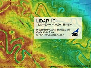
- 1. LiDAR 101 Presented by Aerial Services, Inc. Cedar Falls, Iowa www.AerialServicesInc.com Image: Brownsville, Texas LiDAR / Data: USGA NED Aerial Services, Inc. • Copyright 2007 / All Rights Reserved *Select Imagery is Courtesy of ASI’s LiDAR partner Airborne Solutions, Inc. of Dillon, Colorado Li ght- D etection A nd R anging
- 2. LiDAR, A Useful Tool
- 3. Bare Earth (Brown) Vegetation (Green)
- 9. Contours
- 10. Terrain Profiles
- 12. Shaded Relief Models (3D DTM)
- 13. Digital 3D Fly-Through Click image for fly-through Hit spacebar for next slide
- 14. Bare Earth DEM Surface DEM (DSM) Raw LiDAR Points
- 15. Bare Earth DTM (w/ Photogrammetric Breaklines Photogrammetric Breaklines LiDAR Data Grid & Photogrammetric Breaklines
- 18. Airport Design
- 25. Bare Earth DEM
- 26. 20m DEM Grid w/o Breaklines
- 27. 1m Contours w/o Breaklines
- 28. 1m Contours w/o Breaklines
- 29. 20m DTM Grid w/ Breaklines
- 30. 1m Contours w/ Breaklines
- 31. 1m Contours w/ Breaklines
- 33. LiDAR 101 Presented by Aerial Services, Inc. Cedar Falls, Iowa www.AerialServicesInc.com Li ght- D etection A nd R anging Aerial Services, Inc. • Copyright 2007 / All Rights Reserved *Select Imagery is Courtesy of ASI’s LiDAR partner Airborne Solutions, Inc. of Dillon, Colorado
Editor's Notes
- Initial Slide (put up before presentation, as attendees enter, if possible) Quickly Explain Who: You are and your qualifications are ASI is and it’s qualification & work experience