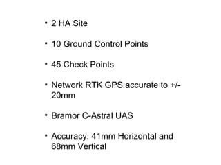
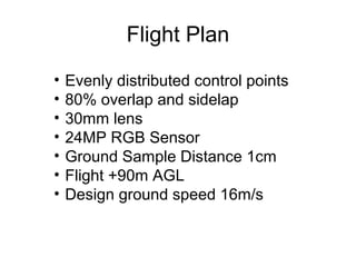
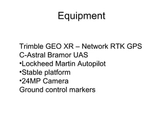
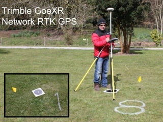
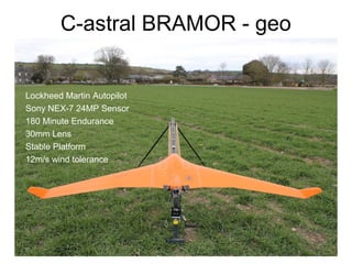
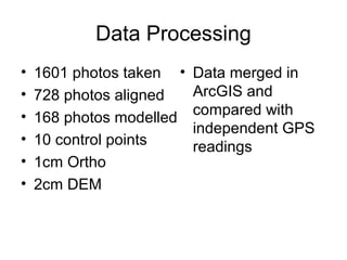
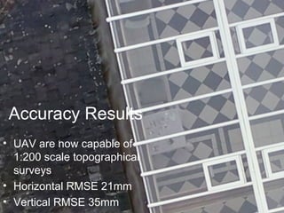
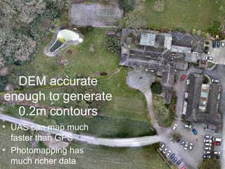
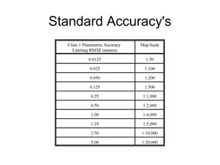
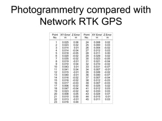
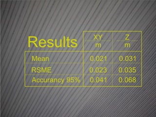
ACCURACY OF UAV
PHOTOGRAMMETRY
COMPARED
WITH NETWORK RTK GPS
P. Barry, R. Coakley
Overview:
• We compared the accuracy of geospatial
data derived from a RPAS and an RTK
GPS
• Aim: To understand the mapping
applications RPAS can deployed for
• Objective: By the end of this presentation
the audience will be able to list the
horizontal and vertical accuracies
achieved by a RPAS
Content
• Baseline History
• Motivation
• RPAS Accuracy
Test
• Results
• Discussion
Baseline History
• Engineering Surveyor
fr on tunnels, roads
and bridges.
• 2,500 Topographic
Surveys.
• Over 20 years of
experience.
• Legal Mapping Export.
• Early adapter of
Survey Technology
• Higher Diploma in GIS
UAV History
• Commercial active with UAV’s since 2012
• Active with UAV’s since 2011
• IAA approved to fly both fix wing and multicopter UAS
• UVS International Committee Member
Motivation
• Viability of UAS for
carrying out GPS
mapping tasks
• Need to measure
UAS accuracy
limitations
• Results obtained in
Sub Optimal
conditions
Reasons for Proving UAV Accuracy
• Mapping applications are accuracy
sensitive
• Cadastral or Boundary mapping 1:1000
• Topographic Mapping 1:500
• As Built Survey 1:100
• Where can UAVs be used?
• 2 HA Site
• 10 Ground Control Points
• 45 Check Points
• Network RTK GPS accurate to +/-
20mm
• Bramor C-Astral UAS
• Accuracy: 41mm Horizontal and
68mm Vertical
Flight Plan
• Evenly distributed control points
• 80% overlap and sidelap
• 30mm lens
• 24MP RGB Sensor
• Ground Sample Distance 1cm
• Flight +90m AGL
• Design ground speed 16m/s
Equipment
Trimble GEO XR – Network RTK GPS
C-Astral Bramor UAS
•Lockheed Martin Autopilot
•Stable platform
•24MP Camera
Ground control markers
Trimble GoeXR
Network RTK GPS
C-astral BRAMOR - geo
• Lockheed Martin Autopilot
• Sony NEX-7 24MP Sensor
• 180 Minute Endurance
• 30mm Lens
• Stable Platform
• 12m/s wind tolerance
Site Conditions
• Cloudy
• 7m/s winds
• 20 degree
windspeed
divergance
Data Processing
• 1601 photos taken
• 728 photos aligned
• 168 photos modelled
• 10 control points
• 1cm Ortho
• 2cm DEM
• Data merged in
ArcGIS and
compared with
independent GPS
readings
Accuracy Results
• UAV are now capable of
1:200 scale topographical
surveys
• Horizontal RMSE 21mm
• Vertical RMSE 35mm
DEM accurate
enough to generate
0.2m contours
• UAS can map much
faster than GPS
• Photomapping has
much richer data
Standard Accuracy's
Photogrammetry compared with
Network RTK GPS
Discussion
• High Precision UAS Mapping accuracy is
similar to GPS
• Time spent mapping using a UAV is
considerably lower than GPS Surveying
• Photographic Data – Quality Assured
Discussion
• UAV photogrammetry is as accurate as
RTK GPS, is much faster and provides a
richer representation of geography.
• Given favourable regulatory conditions this
technology will supercede current
methods for most mapping and surveying
applications.

Accuracy of UAV Photogrammetry

  • 1.
    ACCURACY OF UAV PHOTOGRAMMETRY COMPARED WITHNETWORK RTK GPS P. Barry, R. Coakley
  • 2.
    Overview: • We comparedthe accuracy of geospatial data derived from a RPAS and an RTK GPS • Aim: To understand the mapping applications RPAS can deployed for • Objective: By the end of this presentation the audience will be able to list the horizontal and vertical accuracies achieved by a RPAS
  • 3.
    Content • Baseline History •Motivation • RPAS Accuracy Test • Results • Discussion
  • 4.
    Baseline History • EngineeringSurveyor fr on tunnels, roads and bridges. • 2,500 Topographic Surveys. • Over 20 years of experience. • Legal Mapping Export. • Early adapter of Survey Technology • Higher Diploma in GIS
  • 5.
    UAV History • Commercialactive with UAV’s since 2012 • Active with UAV’s since 2011 • IAA approved to fly both fix wing and multicopter UAS • UVS International Committee Member
  • 6.
    Motivation • Viability ofUAS for carrying out GPS mapping tasks • Need to measure UAS accuracy limitations • Results obtained in Sub Optimal conditions
  • 7.
    Reasons for ProvingUAV Accuracy • Mapping applications are accuracy sensitive • Cadastral or Boundary mapping 1:1000 • Topographic Mapping 1:500 • As Built Survey 1:100 • Where can UAVs be used?
  • 8.
    • 2 HASite • 10 Ground Control Points • 45 Check Points • Network RTK GPS accurate to +/- 20mm • Bramor C-Astral UAS • Accuracy: 41mm Horizontal and 68mm Vertical
  • 9.
    Flight Plan • Evenlydistributed control points • 80% overlap and sidelap • 30mm lens • 24MP RGB Sensor • Ground Sample Distance 1cm • Flight +90m AGL • Design ground speed 16m/s
  • 10.
    Equipment Trimble GEO XR– Network RTK GPS C-Astral Bramor UAS •Lockheed Martin Autopilot •Stable platform •24MP Camera Ground control markers
  • 11.
  • 12.
    C-astral BRAMOR -geo • Lockheed Martin Autopilot • Sony NEX-7 24MP Sensor • 180 Minute Endurance • 30mm Lens • Stable Platform • 12m/s wind tolerance
  • 13.
    Site Conditions • Cloudy •7m/s winds • 20 degree windspeed divergance
  • 14.
    Data Processing • 1601photos taken • 728 photos aligned • 168 photos modelled • 10 control points • 1cm Ortho • 2cm DEM • Data merged in ArcGIS and compared with independent GPS readings
  • 15.
    Accuracy Results • UAVare now capable of 1:200 scale topographical surveys • Horizontal RMSE 21mm • Vertical RMSE 35mm
  • 16.
    DEM accurate enough togenerate 0.2m contours • UAS can map much faster than GPS • Photomapping has much richer data
  • 17.
  • 18.
  • 20.
    Discussion • High PrecisionUAS Mapping accuracy is similar to GPS • Time spent mapping using a UAV is considerably lower than GPS Surveying • Photographic Data – Quality Assured
  • 21.
    Discussion • UAV photogrammetryis as accurate as RTK GPS, is much faster and provides a richer representation of geography. • Given favourable regulatory conditions this technology will supercede current methods for most mapping and surveying applications.