Lab five us geological survey topographic maps & us public
•Download as PPT, PDF•
2 likes•2,335 views
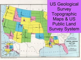
The document provides information on US Geological Survey topographic maps and the US Public Land Survey System for dividing and identifying land. It explains that topographic maps use contour lines to show elevation and features, are produced at various scales by the USGS, and include marginal data like names, dates, coordinates, and scales. It also outlines how the Public Land Survey System divides the continental US into townships and ranges north and east of baselines and principal meridians for identification and ownership of land tracts.
Report
Share
Report
Share
![Topographic Maps ,[object Object]](data:image/gif;base64,R0lGODlhAQABAIAAAAAAAP///yH5BAEAAAAALAAAAAABAAEAAAIBRAA7)
Recommended
Us geological survey topographic maps & us public
The document summarizes topographic maps produced by the US Geological Survey and the US Public Land Survey System used to identify land ownership. It describes the scales and features of USGS topographic maps, including contour lines, place names, and marginal data providing location and map information. It also explains how the Public Land Survey System divides the continental US into a grid of townships, ranges, sections and other units to track land ownership.
Geography skills handbook1
This document introduces various geographic tools used to represent spatial information, including globes, maps, and other visual representations. It discusses how globes provide accurate depictions of location but lack detail, while maps show specific areas in greater detail. The document also covers map projections that translate the round earth onto a flat surface, common map elements like scale and keys, and different types of maps and graphs used by geographers.
Map & globes
A map is a symbolic depiction emphasizing relationships between elements of some space, such as objects, regions, or themes. Many maps are static, fixed to paper or some other durable medium, while others are dynamic or interactive.
Map Projections
The document discusses different types of map projections used to represent the spherical Earth on a flat surface. It describes distortions inherent in all flat map projections and highlights several specific projections including the Mercator, interrupted, Peters, Robinson projections. The key point is that no single projection is perfect and mapmakers must choose one best suited to their specific needs, minimizing important distortions.
2018 GIS in the Rockies Workshop: Coordinate Systems and Projections
This document provides an overview of coordinate systems and map projections. It discusses different types of coordinate systems including geocentric, geodetic, and projected systems. It explains key concepts like ellipsoids, datums, and distortions caused by map projections. Specific projections covered include the Lambert Conformal Conic projection used in state plane coordinate systems. The document is intended to teach the fundamentals of how locations on Earth are defined and represented through different coordinate systems and projections.
2017 PLSC Track: Fundamentals of Coordinate Systems
This document discusses different types of coordinate systems used in surveying and mapping. It begins with an overview of why coordinate systems are important when working with geospatial data. It then describes several types of coordinate systems including geocentric, geodetic, plane, and local systems like State Plane coordinates. Key concepts covered include ellipsoids, datums, projections, and how transforming between systems can distort data. The document aims to explain the fundamentals of different coordinate systems for surveying applications.
Coordinate systems
Coordinate systems define locations on Earth and enable datasets to integrate spatially. There are two main types: geographic coordinate systems use latitude and longitude, while projected coordinate systems define planar coordinates like x and y distances to allow for measurement. When data in different coordinate systems is viewed together in GIS, on-the-fly projection converts between systems to align the data spatially. Geographic transformations define the mathematical operations for converting coordinate values between geographic coordinate systems.
Topographic Maps for Earth Science
This document provides an introduction to using topographic maps for earth science. It explains the purpose and features of topographic maps, including their symbols and scale. It describes how contour lines represent elevation and gradient. It then provides examples for students to practice reading a map, including determining elevation, gradient, distance and navigating terrain features. Exercises guide students to analyze stream gradients, slope steepness, and potential challenges driving in the area.
Projections and coordinate system
Remote sensing and GIS techniques are useful tools for civil engineering projects. There are several models that can be used to represent the shape of the Earth, including flat, spherical, and ellipsoidal models. The ellipsoidal model is needed for accurate measurements over long distances. A geodetic datum defines the parameters of the reference ellipsoid and the orientation of the coordinate system grid. Common datums include NAD27 and NAD83, and transformations allow conversion between them. Map projections, such as Mercator and UTM, are used to represent the 3D Earth on a 2D surface, inevitably distorting some spatial properties like shape, area, or distance.
The universal transverse mercator system
The Universal Transverse Mercator (UTM) system is a global coordinate system that divides the world into narrow longitudinal zones projected using the Transverse Mercator projection. This projection is conformal, meaning angles and shapes are accurately represented locally. Each zone is 6 degrees wide and numbered from 1 to 60, with grid coordinates measured in kilometers from the equator within each zone. The UTM system is used internationally and forms the basis of grid referencing on topographic maps.
Map projections
This document discusses map projections and their properties. Map projections transform the three-dimensional globe onto a two-dimensional surface, necessarily introducing some distortions. The best projection depends on the map's purpose and region. Common projections include cylindrical (like Mercator), conic, and planar/polar types. Key properties that projections aim to preserve, like shape, area, distance and direction, often involve tradeoffs. Choosing a projection minimizes distortions for a map's intended use and geographic extent.
GIS Map Projection
This document discusses map projections, which are methods for translating the three-dimensional surface of the Earth onto a two-dimensional map. It describes three types of developable projection surfaces - conic, cylindrical, and planar - that are used to create different map projections. Specific projections are then outlined, including what geometric properties they preserve or distort (shape, area, distance, direction) and their common uses. The document provides a detailed overview of different GIS map projection techniques.
Map Projection
Projecting maps involves converting the spherical earth into a flat plane, which inevitably causes some distortion of properties like angles, areas, directions, and shapes. There are three main types of map projections - cylindrical, conical, and planar - which involve wrapping a lighted globe onto different geometric surfaces like a cylinder, cone, or flat plane. The Mercator projection specifically was created to aid navigation by representing lines of constant bearing as straight lines, though it distorts the relative sizes of land areas farther from the equator. The Universal Transverse Mercator (UTM) system divides the earth into zones and uses the Mercator projection locally in each to assign Cartesian coordinates.
Map projections
A map projection is a systematic transformation of the latitudes and longitudes of locations from the surface of a sphere or an ellipsoid into locations on a plane. Maps cannot be created without map projections.
Introduction to surveying
This document provides an introduction to the field of surveying. It discusses key topics including:
- The purpose of surveying is to make measurements of objects on, above or below ground to show their relative positions on paper. This helps avoid disputes over property lines, borders, and supports planning projects.
- There are two main types of surveying - plane and geodetic. Plane surveying neglects earth's curvature over small areas, while geodetic considers curvature for larger areas.
- Fundamental surveying principles include working from whole to part and taking extra care in establishing control points for accuracy. Common surveying methods are also outlined like triangulation, traversing, and different types of surveys.
Review 2a _contour_lines_sc
The document contains a series of questions about topographic maps and contour lines. The questions require analyzing contour line patterns, determining elevations, slopes, and river flow directions. They also involve constructing topographic profiles by plotting elevation points along cross-sections and connecting them with curved lines.
Map Projection
The document discusses three common types of map projections: Mercator, equal area, and gnomonic. It describes the Mercator projection as a cylindrical projection that accurately shows directions but distorts sizes, especially at the poles. The equal area projection represents areas correctly on the map using a conic projection. While it shows correct landmass sizes, it alters shapes. The document provides details on the characteristics and purposes of each projection type.
Map projection
This document discusses different types of map projections. It begins by defining map projection as a systematic drawing of parallels and meridians on a plane surface that corresponds to locations on Earth. It notes that all projections necessarily distort the surface in some way. Projections are classified based on their construction method, development surface, preserved properties, and position of the light source. Common projection types discussed include cylindrical, conic, azimuthal, Mercator, sinusoidal, and polyconic. The key properties and uses of each type are outlined. The document emphasizes that the purpose of the map determines the best projection to use.
Seminar
This document discusses the Universal Transverse Mercator (UTM) coordinate system. It explains that the UTM system divides the Earth into 60 zones, each being a six-degree band of longitude, and uses a secant transverse Mercator projection in each zone. It also defines important terms related to map projections like longitude, latitude, northing, easting, and coordinate systems. In particular, it notes that the UTM system uses a 2-dimensional Cartesian coordinate system to give locations on Earth's surface independently of vertical position.
Map projection Map and Globe
This document discusses map projections and surveying. It defines a map as a representation of the Earth or part of it on a plane surface with reference to a scale. Key components of maps are identified as the title, scale, direction, grid system, and legend. Different types of maps like physical, political, and thematic maps are described. The differences between maps and globes are outlined. Map projection is defined as the representation of the Earth's graticule on a plan surface. Different properties and classifications of map projections are listed.
datum
Spheroid, datum, projection, and coordinate systems are used to locate positions on Earth. A spheroid is a mathematical model that approximates the Earth's shape as an oblate spheroid. A datum defines the reference frame for latitude and longitude coordinates and relates the spheroid to the Earth's center. Projections transform 3D spheroid coordinates onto a 2D surface like a map, introducing some distortion of shapes, areas, distances or directions. Common projections include transverse Mercator, UTM, and lambert conformal conic. Coordinate systems then allow measurement of positions on the projected 2D surface. Understanding these concepts is important for accurately locating geographic features.
Earth Coordinate Systems
This Presentation is to made concepts about measuring the earth (to locate position of any person on the whole earth). For this purpose we re going step by step basis in this presentation.These steps are mentioned as contents. After that you may able to learn about measuring a person's position of earth. Thank you!
Datum
This document discusses datums in geodesy. It begins by defining a datum as a reference frame for locating points on Earth's surface. It then describes the key components of a datum including the spheroid shape it defines and parameters like semi-major axis. It discusses different types of datums such as geocentric datums based on the Earth's center and local datums that are specific to a particular region. Examples of issues with local datums are also provided. The document outlines horizontal and vertical datums, common transformation methods, and applications of datums in areas like GPS and mapping.
Coordinate systems (Lecture 3)
This document discusses various coordinate systems used to define positions in satellite navigation. It describes geocentric systems like ECEF and ECI that use the Earth's center as the origin, as well as topocentric systems that use the observer's location. It also discusses spherical coordinate systems that define positions using radial distance, elevation and azimuth angles. Key systems covered include WGS-84 used in GPS and PZ-90.02 used in GLONASS. While definitions are close, realized coordinates between the two systems can differ by up to 0.5 meters.
Differentiation between Global and Local Datum from Different aspect
Differentiation between Global and Local Datum from Different aspect
Spatial professionals are required to deal with an increasingly wide range
of positioning information obtained from various sources including
terrestrial surveying, Global Navigation Satellite System (GNSS)
observations and online GNSS processing services. These positions refer
to a multitude of local, national, and global datums. A clear understanding
of the different coordinate reference systems and datums in use today and
the appropriate transformations between these are therefore essential to
ensure rigorous consideration of reference frame variations to
produce high-quality outcomes in spatial data analysis tasks.
Geographic coordinate system & map projection
The document discusses geographic coordinate systems and map projections. It defines key concepts like geoid, spheroid, datum, latitude and longitude, projections, and the UTM coordinate system. The UTM system divides the globe into 60 zones, each 6 degrees wide, and uses a Transverse Mercator projection within each zone. UTM coordinates express a point's easting and northing distances in meters from the central meridian and equator/south pole.
Map Projections ―concepts, classes and usage
The document discusses different types of map projections used to represent the spherical Earth on a flat surface. It begins by explaining that map projections transform 3D global coordinates to 2D planar coordinates, which necessarily distorts properties like distances, angles, or areas. It then covers key projection categories (cylindrical, conic, azimuthal), their characteristic properties and examples. Specific projections discussed include Mercator, UTM, and polar stereographic. The document emphasizes that the appropriate projection depends on the map's intended use and which distortions are least important. It encourages map users to understand basic projection concepts.
UTM UNIVERSAL TRANSVERSE MERCATOR
This presentation is on utm ( universal transverse mercator )
the main content of this presentation are
OVERVIEW OF ZONES AND SUBZONES
FALSE VALUES OF ORIGIN
IDENTIFICATION OF 100*100KM SQ.
REGION AND SUB-REGIONS IDENTIFICATION
SUMMARY of UTM
Lab four isolines and contour lines
Isolines, also known as contour lines, connect points of equal value on a map. They show characteristics such as elevation, temperature, rainfall, and pressure. Isolines are always closed, do not cross, and indicate a rapid change where spaced closely and a gradual change where spaced far apart. Different types of isolines include isobars for pressure, isotherms for temperature, and contour lines for elevation shown on topographic maps.
C:\Fakepath\Earth’S Grid
The document discusses the Earth's grid system of latitude and longitude which is used to locate positions on the planet. Latitude lines run parallel to the equator and indicate distances north and south, while longitude lines run perpendicular and indicate distances east and west from the prime meridian. The document provides examples of how to determine latitude and longitude coordinates and explains key terms like the equator, prime meridian, and international date line.
More Related Content
What's hot
Projections and coordinate system
Remote sensing and GIS techniques are useful tools for civil engineering projects. There are several models that can be used to represent the shape of the Earth, including flat, spherical, and ellipsoidal models. The ellipsoidal model is needed for accurate measurements over long distances. A geodetic datum defines the parameters of the reference ellipsoid and the orientation of the coordinate system grid. Common datums include NAD27 and NAD83, and transformations allow conversion between them. Map projections, such as Mercator and UTM, are used to represent the 3D Earth on a 2D surface, inevitably distorting some spatial properties like shape, area, or distance.
The universal transverse mercator system
The Universal Transverse Mercator (UTM) system is a global coordinate system that divides the world into narrow longitudinal zones projected using the Transverse Mercator projection. This projection is conformal, meaning angles and shapes are accurately represented locally. Each zone is 6 degrees wide and numbered from 1 to 60, with grid coordinates measured in kilometers from the equator within each zone. The UTM system is used internationally and forms the basis of grid referencing on topographic maps.
Map projections
This document discusses map projections and their properties. Map projections transform the three-dimensional globe onto a two-dimensional surface, necessarily introducing some distortions. The best projection depends on the map's purpose and region. Common projections include cylindrical (like Mercator), conic, and planar/polar types. Key properties that projections aim to preserve, like shape, area, distance and direction, often involve tradeoffs. Choosing a projection minimizes distortions for a map's intended use and geographic extent.
GIS Map Projection
This document discusses map projections, which are methods for translating the three-dimensional surface of the Earth onto a two-dimensional map. It describes three types of developable projection surfaces - conic, cylindrical, and planar - that are used to create different map projections. Specific projections are then outlined, including what geometric properties they preserve or distort (shape, area, distance, direction) and their common uses. The document provides a detailed overview of different GIS map projection techniques.
Map Projection
Projecting maps involves converting the spherical earth into a flat plane, which inevitably causes some distortion of properties like angles, areas, directions, and shapes. There are three main types of map projections - cylindrical, conical, and planar - which involve wrapping a lighted globe onto different geometric surfaces like a cylinder, cone, or flat plane. The Mercator projection specifically was created to aid navigation by representing lines of constant bearing as straight lines, though it distorts the relative sizes of land areas farther from the equator. The Universal Transverse Mercator (UTM) system divides the earth into zones and uses the Mercator projection locally in each to assign Cartesian coordinates.
Map projections
A map projection is a systematic transformation of the latitudes and longitudes of locations from the surface of a sphere or an ellipsoid into locations on a plane. Maps cannot be created without map projections.
Introduction to surveying
This document provides an introduction to the field of surveying. It discusses key topics including:
- The purpose of surveying is to make measurements of objects on, above or below ground to show their relative positions on paper. This helps avoid disputes over property lines, borders, and supports planning projects.
- There are two main types of surveying - plane and geodetic. Plane surveying neglects earth's curvature over small areas, while geodetic considers curvature for larger areas.
- Fundamental surveying principles include working from whole to part and taking extra care in establishing control points for accuracy. Common surveying methods are also outlined like triangulation, traversing, and different types of surveys.
Review 2a _contour_lines_sc
The document contains a series of questions about topographic maps and contour lines. The questions require analyzing contour line patterns, determining elevations, slopes, and river flow directions. They also involve constructing topographic profiles by plotting elevation points along cross-sections and connecting them with curved lines.
Map Projection
The document discusses three common types of map projections: Mercator, equal area, and gnomonic. It describes the Mercator projection as a cylindrical projection that accurately shows directions but distorts sizes, especially at the poles. The equal area projection represents areas correctly on the map using a conic projection. While it shows correct landmass sizes, it alters shapes. The document provides details on the characteristics and purposes of each projection type.
Map projection
This document discusses different types of map projections. It begins by defining map projection as a systematic drawing of parallels and meridians on a plane surface that corresponds to locations on Earth. It notes that all projections necessarily distort the surface in some way. Projections are classified based on their construction method, development surface, preserved properties, and position of the light source. Common projection types discussed include cylindrical, conic, azimuthal, Mercator, sinusoidal, and polyconic. The key properties and uses of each type are outlined. The document emphasizes that the purpose of the map determines the best projection to use.
Seminar
This document discusses the Universal Transverse Mercator (UTM) coordinate system. It explains that the UTM system divides the Earth into 60 zones, each being a six-degree band of longitude, and uses a secant transverse Mercator projection in each zone. It also defines important terms related to map projections like longitude, latitude, northing, easting, and coordinate systems. In particular, it notes that the UTM system uses a 2-dimensional Cartesian coordinate system to give locations on Earth's surface independently of vertical position.
Map projection Map and Globe
This document discusses map projections and surveying. It defines a map as a representation of the Earth or part of it on a plane surface with reference to a scale. Key components of maps are identified as the title, scale, direction, grid system, and legend. Different types of maps like physical, political, and thematic maps are described. The differences between maps and globes are outlined. Map projection is defined as the representation of the Earth's graticule on a plan surface. Different properties and classifications of map projections are listed.
datum
Spheroid, datum, projection, and coordinate systems are used to locate positions on Earth. A spheroid is a mathematical model that approximates the Earth's shape as an oblate spheroid. A datum defines the reference frame for latitude and longitude coordinates and relates the spheroid to the Earth's center. Projections transform 3D spheroid coordinates onto a 2D surface like a map, introducing some distortion of shapes, areas, distances or directions. Common projections include transverse Mercator, UTM, and lambert conformal conic. Coordinate systems then allow measurement of positions on the projected 2D surface. Understanding these concepts is important for accurately locating geographic features.
Earth Coordinate Systems
This Presentation is to made concepts about measuring the earth (to locate position of any person on the whole earth). For this purpose we re going step by step basis in this presentation.These steps are mentioned as contents. After that you may able to learn about measuring a person's position of earth. Thank you!
Datum
This document discusses datums in geodesy. It begins by defining a datum as a reference frame for locating points on Earth's surface. It then describes the key components of a datum including the spheroid shape it defines and parameters like semi-major axis. It discusses different types of datums such as geocentric datums based on the Earth's center and local datums that are specific to a particular region. Examples of issues with local datums are also provided. The document outlines horizontal and vertical datums, common transformation methods, and applications of datums in areas like GPS and mapping.
Coordinate systems (Lecture 3)
This document discusses various coordinate systems used to define positions in satellite navigation. It describes geocentric systems like ECEF and ECI that use the Earth's center as the origin, as well as topocentric systems that use the observer's location. It also discusses spherical coordinate systems that define positions using radial distance, elevation and azimuth angles. Key systems covered include WGS-84 used in GPS and PZ-90.02 used in GLONASS. While definitions are close, realized coordinates between the two systems can differ by up to 0.5 meters.
Differentiation between Global and Local Datum from Different aspect
Differentiation between Global and Local Datum from Different aspect
Spatial professionals are required to deal with an increasingly wide range
of positioning information obtained from various sources including
terrestrial surveying, Global Navigation Satellite System (GNSS)
observations and online GNSS processing services. These positions refer
to a multitude of local, national, and global datums. A clear understanding
of the different coordinate reference systems and datums in use today and
the appropriate transformations between these are therefore essential to
ensure rigorous consideration of reference frame variations to
produce high-quality outcomes in spatial data analysis tasks.
Geographic coordinate system & map projection
The document discusses geographic coordinate systems and map projections. It defines key concepts like geoid, spheroid, datum, latitude and longitude, projections, and the UTM coordinate system. The UTM system divides the globe into 60 zones, each 6 degrees wide, and uses a Transverse Mercator projection within each zone. UTM coordinates express a point's easting and northing distances in meters from the central meridian and equator/south pole.
Map Projections ―concepts, classes and usage
The document discusses different types of map projections used to represent the spherical Earth on a flat surface. It begins by explaining that map projections transform 3D global coordinates to 2D planar coordinates, which necessarily distorts properties like distances, angles, or areas. It then covers key projection categories (cylindrical, conic, azimuthal), their characteristic properties and examples. Specific projections discussed include Mercator, UTM, and polar stereographic. The document emphasizes that the appropriate projection depends on the map's intended use and which distortions are least important. It encourages map users to understand basic projection concepts.
UTM UNIVERSAL TRANSVERSE MERCATOR
This presentation is on utm ( universal transverse mercator )
the main content of this presentation are
OVERVIEW OF ZONES AND SUBZONES
FALSE VALUES OF ORIGIN
IDENTIFICATION OF 100*100KM SQ.
REGION AND SUB-REGIONS IDENTIFICATION
SUMMARY of UTM
What's hot (20)
Differentiation between Global and Local Datum from Different aspect
Differentiation between Global and Local Datum from Different aspect
Viewers also liked
Lab four isolines and contour lines
Isolines, also known as contour lines, connect points of equal value on a map. They show characteristics such as elevation, temperature, rainfall, and pressure. Isolines are always closed, do not cross, and indicate a rapid change where spaced closely and a gradual change where spaced far apart. Different types of isolines include isobars for pressure, isotherms for temperature, and contour lines for elevation shown on topographic maps.
C:\Fakepath\Earth’S Grid
The document discusses the Earth's grid system of latitude and longitude which is used to locate positions on the planet. Latitude lines run parallel to the equator and indicate distances north and south, while longitude lines run perpendicular and indicate distances east and west from the prime meridian. The document provides examples of how to determine latitude and longitude coordinates and explains key terms like the equator, prime meridian, and international date line.
FOSTEr in MED Pilot project Conference in Cagliari 28/06/2016: pilots present...
In this presentation, the University of Cagliari presents the solar photovoltaic pilot projects integrated in 5 public buildings in Cagliari (Italy); Alexandria (Egypt); Beirut (Lebanon); Tunis (Tunisia); and Aqaba (Jordan).
Earth’S Grid
The document discusses the Earth's grid system of latitude and longitude which is used to locate positions on the planet. Latitude lines run parallel to the equator and indicate distances north and south, while longitude lines run perpendicular and indicate distances east and west from the prime meridian. Key lines include the equator at 0 degrees latitude, and the prime meridian and international date line which delineate the eastern and western hemispheres. Several examples are provided to illustrate how the grid system can be used to determine locations.
Lab five us geological survey topographic maps & us public
This document provides information about topographic maps produced by the US Geological Survey and the US Public Land Survey System. It describes the scales and features of USGS topographic maps, including contour lines, map symbols, and marginal data. It also explains the township and range grid system used to identify land ownership, with townships divided into sections, quarter sections, and smaller plots.
Lab two location and time
The document discusses latitude, longitude, time zones, and daylight saving time. It explains that:
1) Latitude and longitude were developed in the Middle Ages to create a geographic grid system. Latitude lines run horizontally while longitude lines run vertically.
2) There are 24 time zones that extend 7.5 degrees on either side of standard meridians that are 15 degrees apart, starting from the Prime Meridian in Greenwich, England.
3) Daylight saving time sets clocks forward by one hour in spring and back in fall in many countries to make better use of daylight hours. Crossing the International Date Line results in a one day shift in calendar date.
Solstice and equinox
Equinoxes occur twice yearly when the sun is directly above the equator and day and night are approximately equal in length. Solstices occur twice yearly when the sun reaches its highest or lowest point in the sky, resulting in the longest and shortest days of the year in the summer and winter respectively in each hemisphere. The document then provides details on the timing and effects of the summer and winter solstices and spring and autumn equinoxes in both hemispheres.
Topography powerpoint
The document defines and explains topography and topographic maps. It describes how topographic maps use contour lines to represent elevation, with closer lines indicating steeper slopes. Contour lines circle around mountains and point upstream along streams. Other symbols convey features like roads, vegetation, buildings and landforms. Index contours are labeled to indicate the contour interval elevation difference between lines. Topographic maps provide visual information about natural and man-made terrain.
3 Things Every Sales Team Needs to Be Thinking About in 2017
Thinking about your sales team's goals for 2017? Drift's VP of Sales shares 3 things you can do to improve conversion rates and drive more revenue.
Read the full story on the Drift blog here: http://blog.drift.com/sales-team-tips
How to Become a Thought Leader in Your Niche
Are bloggers thought leaders? Here are some tips on how you can become one. Provide great value, put awesome content out there on a regular basis, and help others.
Viewers also liked (11)
FOSTEr in MED Pilot project Conference in Cagliari 28/06/2016: pilots present...
FOSTEr in MED Pilot project Conference in Cagliari 28/06/2016: pilots present...
Lab five us geological survey topographic maps & us public
Lab five us geological survey topographic maps & us public
3 Things Every Sales Team Needs to Be Thinking About in 2017
3 Things Every Sales Team Needs to Be Thinking About in 2017
Similar to Lab five us geological survey topographic maps & us public
Township&ranges
The document discusses how the United States, states, and land within states are divided and mapped using a township and range system with parallels of latitude and meridians of longitude. Each state has a baseline and principal meridian defining the starting points for townships, which are then divided into ranges and further subdivided into congressional townships of six miles by six miles containing 36 sections of one square mile each. Specific locations within this system can be precisely noted such as "H is in the northwest quarter of the northeast quarter of the 10th district of the second south township and the third west range."
Land Navigation Presentation
This document provides an overview of land navigation training that includes two parts: map reading skills and compass use. Part one covers important map features like marginal information, symbols, terrain features, and determining elevation from contour lines. It emphasizes the purpose of maps for navigation and importance of checking the map date. Part two introduces navigation techniques like determining grid coordinates using a protractor and understanding military compass features. The training aims to teach service members key map reading and land navigation skills for navigating terrain and completing missions.
1 How does a topographic map show the shape of the land sur.pdf
1. How does a topographic map show the shape of the land surface? For example, how do
topographic maps indicate steeper slopes? How are gentler slopes portrayed? How can you
identify
stream or river valleys on maps?
2. What are contour lines? What is an index contour?
3. Define contour interval.
4. What does a fractional scale of 1:48,000 mean?
5. What is a bar scale and how is it used?
6. The basic unit of latitude and longitude is the degree. How is the degree subdivided?
7. Latitude is measured in degrees N or S of what line? What is the range of possible values (in
degrees) for latitude?
8. Longitude is measured in degrees W or E of what line? Where is that line located? What is the
range
of possible values (in degrees) for longitude?
Introduction Topograpbic maps illustrate scale, width, length, and height of landforms. Geologic
maps show the distribution of different rock units and geologic features, such as faults, at the
surface of the Earth. In this lab you will become familiar with both types of maps which are
important tools for anyone studying the earth or its resources. Learning Outcomes - Explain how
contours are used to show elevation information and landforms on a map. (questions 13) -
Understand and explain different types of map scale, such as fractional scale and bar scale.
(questions 4-5) - Explain how latitude and longitude are used to describe location. (questions 6-8)
- Draw and use contours to visualize spatial data (such as spot elevations). (question 9) - Find the
latitude and longitude of a location on a map. (questions 10, 17, 18) - Read elevation data and
interpret contours on a topographic map.(questions 11, 12, 19) - Calculate elevation change and
gradient (slope) from topographic maps.(questions 13, 21) - Read distances on a map using a
ruler and bar scale.(questions 14-16; 20) - Interpret ages of rock units on a geologic map
(questions 22-23) - Identify geologic structures on a geologic map (questions 24-27) - Draw a
geologic cross section using locations of contacts and angles of dip on a geologic map (questions
28-30) - Identify types of folds or faults on a geologic cross section (questions 28-30) Map
Coordinate Systems A coordinate system allows us to describe the location of any point on the
surface of the Earth. Lines of latitude (also known as parallels) are the horizontal lines that circle
the globe. These lines are known as parallels because the run in the same direction as (are
parallel to) the Equator. The Equator is the imaginary line located at 0 latitude and is halfway
between the North Pole and the South Pole, which are 180 apart. This means the South Pole is 90
S and the North Pole is 90N. Lines that run from the North Pole to the South Pole are lines of
longitude (also known as meridians). The line at 0 longitude is the prime meridian and runs
through the Royal Observatory in Greenwich, England. Meridians are counted east and west from
the prime meridian up to a maximum of 180 longitude at the.
Other map symbols on topographic maps Occasionally you will.pdf
Other map symbols on topographic maps: Occasionally you will see an elevation listed at a
specific spot on a map that is not located on a contour line, commonly on the top of hills. These
elevations have been surveyed and are referred to as bench marks. Other standardized symbols
and colors used on most government maps include cultural features (made by people) generally
drawn in black; forests or woods shown in green; blue is used for bodies of water; and red is used
for roads and some land subdivision lines. Contour lines are usually shaded brown. When USGS
maps are revised, any new features (e.g. roads, suburbs) are shaded purple. 10. Use the bar
scale at the bottom of the map immediately below and determine the distance between X and Y on
the map. ( X and Y are underlined in red). km Get a topographic map from your instructor and
answer questions 11 through 15. a. What is the name of the topographic map? b. Who published
the map? (hint: look at the bottom of the map)Map scales can be thought of as the distance
between points on a map corresponding to some true distance on the ground. The ratio of map
distance to true distance is scale. There are commonly two types of scales listed on maps: a
graphic scale or bar scale, and a fractional scale. A bar scale is a drawn line or bar of some length
(Figure 10A ). A fractional scale is expressed as a ratio, e.g. 1:24,000 means one inch on the map
equals 24,000 inches on the ground (Figure 9 ). Bar scales can be used to determine straight-line
distances between places fairly easily on maps by using a ruler, or by laying the edge of a piece of
paper between the points on the map you want to know the distance between. Shift the paper
edge to the bar scale and use the scale like a ruler to measure the map distance. Figure 10A. The
left end of the bar is not zero; the arrow points to the location of zero miles on the bar scale. The
total length of this bar is FIVE miles, one mile to the left of the zero plus four miles to the right of
the zero. A common error with bar scales is to treat the left end of the line as zero. Pay attention to
where the zero point on the bar is actually located. Measuring distances along curvilinear features,
e.g. rivers. You canl u cat a series of straight-line segments as shown in figure (b) and (c). North
arrows drawn on a map refer to true geographic north (underlined in red on Figure 9). Compass
Magnetic Declination needles do not point toward the geographic north pole at most places on
earth, but toward the magnetic pole. The angular distance between true north and magnetic north
is called the magnetic declination. A compass must be adjusted for declination at the local area.
The magnetic declination on Figure 9 is listed as 20.5 as measured in 1962.in an.
elements_surveying
Utah uses the rectangular survey system to divide land into townships, sections, and fractional parts for mapping. Each township is six miles by six miles and divided into 36 sections of one square mile each. Sections can be further divided into quarter sections, half quarters, and quarter-quarter sections. Adjustments are needed due to the curvature of the Earth. The State Plane Coordinate System provides consistent bearings statewide and relates all monuments mathematically.
Map Reading Skills.pptx
This document provides an overview of important concepts for map reading skills. It discusses key components of maps, including the title, scale, direction, grid system, projection, and legend. It also covers cardinal directions, latitude and longitude lines, and how to locate places using their coordinates. The purpose is to teach life skills for interpreting and navigating using maps.
Maps as Models of Earth
This document provides information about key concepts for reading and understanding topographic maps, including:
- Contour lines connect points of equal elevation and are used to show elevation changes on topographic maps. Closer contour lines indicate steeper slopes.
- Relief, elevation difference between highest and lowest points in an area, determines the contour interval or spacing between lines.
- Contour lines have set rules like never crossing, being V-shaped in valleys, and forming closed circles around peaks.
Maps as Models of Earth
This document provides an overview of key concepts for understanding topographic maps, including:
- Contour lines connect points of equal elevation and are used to show elevation changes on topographic maps. Contour interval is the difference in elevation between lines.
- Steeper slopes are shown by closer contour line spacing, while more gentle slopes have lines farther apart. Contour lines never cross and have specific shapes depending on terrain features.
- Topographic maps also use symbols, colors, and index contours to represent landforms and elevation information. These maps provide important data for understanding Earth's surface features and elevation.
BOLTSS - Mapping Geography
BOLTSS
Mapping Geography
Acronym: BOLTSS
Border - Orientation - Legend - Title -- Scale - Source
Six (6) essential features of a MAP.
Geographic Information System(GIS).pptx
The document provides an overview of geographic information systems (GIS). It discusses how GIS is used in multiple disciplines like agriculture, natural resource management, and urban planning. It also covers key GIS concepts like location-allocation analysis, which involves finding optimal locations to serve demand while minimizing costs. Additionally, the document defines common map elements such as point, line, and area features and the typical components of maps like titles, legends, scales, grids, and compass roses.
Toposheet interpretation
The document provides information on key concepts related to maps and map reading, including:
1) Maps are graphical representations of physical and cultural features on Earth's surface, with symbols used to denote features. Scale allows large areas to be shown on small maps and is expressed verbally, as a ratio, or with a bar scale.
2) Grid references use a system of eastings and northings to precisely locate features on maps divided into grids. Contour lines and spot heights indicate land elevation and relief. Hachures and shading are also used to represent relief.
3) Maps use colors to represent different features - green for forests, blue for water, etc. Settlement patterns, drainage patterns, transportation
Practical work in geography
Gives details about maps, projections,their uses and also about data presentation. Made for students for 11th and 12th standard. Also helpful for competitive examinations. This file is made from NCERT books of class 11th and 12th books titled "Practical work in Geography"
The Mapping Skills
This presentation will help our young geographers who are on the verge of understanding geographical skills and how do different maps help them to understand different features of the Earth and the area where they live.
Maps And Globes Are Models Of The Earth
1. Maps and globes are models that represent features on Earth's surface. Maps show natural and human features from an above view, while globes show Earth as seen from space with accurate sizes and shapes.
2. Maps use symbols to indicate different land features such as mountains, plateaus, and plains. They also use scales and legends to relate distances on maps to actual distances and explain symbols.
3. Latitude and longitude lines are used to locate positions on Earth, with latitude measuring distances north and south of the equator and longitude measuring distances east and west of the prime meridian.
maps & symbols which is use in india and other parts of world also
Road maps and navigational maps like aeronautical and nautical charts are the most widely used maps. Local surveys by municipalities and other local agencies produce the largest number of map sheets. Many national surveying projects have also been carried out by military organizations like the British Ordnance Survey, which is renowned for its detailed work. Maps use a geographic grid of longitude and latitude to locate features and describe areas. The scale of a map defines the relationship between distances on the map and on the earth. A cross-section can show landscape height variations by plotting contour lines intersecting a transect line.
Geography Skills
There are several types of map projections that are used to represent the spherical Earth on a flat surface. All map projections involve some degree of distortion of shapes, sizes, or distances. The Mercator projection increasingly distorts distances the farther one moves from the equator, while the Robinson and Goode's interrupted projections aim to minimize distortion of landmasses. Other map features discussed include hemispheres, latitude and longitude grid systems, directions, scales, and different types of thematic maps.
Exploring geographic world
This document provides an overview of geography and geographic concepts. It discusses the definition of geography as the study of the world's environment and human interaction within it. It also outlines key geographic tools like maps and atlases and concepts like the five themes of geography, map projections, grid systems and reading coordinates. The goal is to help readers understand geography and how to make, read and use maps.
FCP 3 - Map Reading - CFSGT Putland - Mar 10
The document discusses map reading skills, defining a map, types of maps like topographical maps, how topographical features are represented through techniques like contours and spot heights, scales which show the ratio of distance on a map to distance on the ground, and grid references which provide a precise way to locate points on a map using eastings and northings. It aims to enable cadets to navigate using maps, understand terrain, and communicate locations accurately.
Exploring geography
Geography is the study of the world's environments and human-environment interactions. It has two components: physical geography, which examines the natural world, and human geography, which studies human cultures and activities. Maps are an important tool for geographers, as they can display large amounts of information visually. Different types of maps include political, physical, and thematic maps. Geographers use tools like GIS, aerial photography, and GPS to collect and analyze geographic data and create maps.
Lecture 03 map
Maps are visual representations of spatial relationships and characteristics of an area. There are several key elements that should be included in every map: the data frame, legend, title, north arrow, scale, and citation. There are seven main types of maps: political maps, physical maps, topographic maps, climate maps, economic/resource maps, road maps, and thematic maps. Each type of map serves a different purpose in visualizing and representing different kinds of geographic and statistical information.
Similar to Lab five us geological survey topographic maps & us public (20)
1 How does a topographic map show the shape of the land sur.pdf
1 How does a topographic map show the shape of the land sur.pdf
Other map symbols on topographic maps Occasionally you will.pdf
Other map symbols on topographic maps Occasionally you will.pdf
maps & symbols which is use in india and other parts of world also
maps & symbols which is use in india and other parts of world also
More from lschmidt1170
How did the magna carta influence the united states bill of rights
How did the magna carta influence the united states bill of rights
Sustainable development goals
The document discusses the Sustainable Development Goals (SDGs) created by the United Nations in 2015. The 17 goals aim to eliminate poverty, hunger, disease, and climate change by 2030. Progress has already been made in reducing poverty, hunger, and disease in recent decades. The UNDP works with countries around the world to achieve the ambitious goals by 2030.
What is the magna carta and why there is a google doodle telegraph
What is the magna carta and why there is a google doodle telegraph
Universal declaration of human rights
This document is the illustrated edition of the Universal Declaration of Human Rights published by the United Nations in several languages. It was created through a partnership between artist Yacine Ait Kaci, the UN Regional Information Centre, and the UN High Commissioner for Human Rights. The drawings in the edition are copyrighted but the text can be reproduced and translated freely provided the UN emblem is removed and proper credits are included.
Magna carta and the law of nature
This document discusses a lecture given by Richard H. Helmholz on the topic of Magna Carta and the law of nature. The lecture explores possible connections between Magna Carta, which was enacted in 1215, and principles of natural law as understood at that time and for centuries afterward. While recent scholarship has been skeptical of portraying Magna Carta as guaranteeing broad human rights or natural law, the lecture examines whether the enactment of Magna Carta could be connected to contemporary understandings of justice and natural law. The lecture acknowledges limitations in proving conclusions definitively but aims to reasonably infer connections from evidence in Magna Carta's clauses based on natural law perspectives current at the time, rather than an
King john the most evil monarch in britain's history telegraph
King john the most evil monarch in britain's history telegraph
How did the magna carta influence the united states bill of rights
How did the magna carta influence the united states bill of rights
Constitution billofrightsfacts
James Madison proposed the Bill of Rights in response to calls for more protections of basic liberties in the newly ratified Constitution. The first ten amendments were ratified in 1791 and guarantee freedoms like speech, religion, press, trial rights, search and seizure protections, and the right to bear arms. The Bill of Rights plays a central role in American law and government and protects fundamental rights and values of the nation.
Feudal strength! henry ii and the struggle for royal control in
Henry II faced the challenge of reasserting royal authority over powerful feudal barons who had gained influence and control over lands during the chaotic reign of King Stephen. Henry worked to curb the barons' power by destroying unauthorized castles and establishing a centralized system of common law with the crown at its head. Through military prowess and administrative reforms, Henry was largely successful in reclaiming royal power, expanding the authority of the monarchy in legal matters and its relationship with the church. However, the difficulties of controlling a vast feudal empire remained immense for even a skilled ruler like Henry.
Constitution
The Constitution establishes the legislative branch of the US government, known as Congress, which is made up of the Senate and House of Representatives. It outlines the composition and election process for both chambers, as well as their powers and responsibilities. These include the ability to create laws, approve the federal budget, declare war, and impeach and remove the president or other federal officials from office. The Constitution also establishes the basic framework for how legislation is passed and how the executive branch, through the president, can veto bills.
Bill of rights
The document summarizes the Bill of Rights, which was ratified on December 15, 1791. It outlines the first ten amendments to the US Constitution, which aim to protect individual liberties and limit the powers of the federal government. The amendments establish protections for freedoms of religion, speech, press, assembly, gun ownership, due process, fair trials, and prohibit cruel and unusual punishment. They also reserve powers not delegated to the federal government to the states and people.
Denis haley catherine douglas geneaology 1793 to 1989
The document discusses the benefits of exercise for mental health. Regular physical activity can help reduce anxiety and depression and improve mood and cognitive function. Exercise causes chemical changes in the brain that may help protect against mental illness and improve symptoms.
Na map 1 with terms
This document lists various human features including states, provinces, cities, water features like rivers and lakes, and landforms found in Eastern North America. It includes 24 US states and provinces and over 50 cities located within them. The water features section lists 9 rivers, 5 bays/other bodies of water, and 5 Great Lakes. The landforms section names 7 islands and 5 mountain ranges as well as 3 peninsulas in the region.
Introfall 2016 14week
This document provides information about a 14-week online physical geography course taught by Professor Lisa Schmidt. The course will cover basic elements of geography including climate, landforms, water, soils, plants and animals. Students will study these topics and their global patterns. Assignments include weekly discussions, chapter quizzes, map quizzes and four exams. The course aims to give students an understanding of the earth's physical systems and human relationships with the environment.
Intro fall 2016 geog lab
This document provides information for a geography lab course including:
- Details about the instructor, their contact information, office hours and the class schedule.
- Prerequisites, required textbooks and additional materials needed for the course.
- The student learning outcomes and course objectives focused on understanding physical geography concepts.
- Expectations for labs, exams, grading criteria and policies on absences, tardiness, disruptions and academic honesty.
- Resources available to support student success and an overview of what geography is as a field of study.
Fall 2016 intro wed
This document provides an overview and syllabus for a physical geography course. It outlines that students will learn about the basic elements of geography, including climate, landforms, water, soils, plants and animals. They will examine the relationships between these elements and their worldwide distribution patterns. The course will cover four environmental spheres - the atmosphere, hydrosphere, lithosphere and biosphere. Students will take exams, quizzes on textbook chapters and maps, and do a presentation on a physical geography topic. The syllabus details course policies on grading, attendance and academic honesty.
Fall 2016 intro mon
This document provides an overview of a physical geography course. It outlines the course objectives which are to introduce students to basic concepts in physical geography including the four environmental spheres of atmosphere, hydrosphere, lithosphere, and biosphere. It details required textbooks, exams, quizzes, assignments, and presentations for the course. Students are expected to demonstrate understanding of geographic concepts and the distribution of natural phenomena through map studies. The syllabus emphasizes academic honesty and provides contact information for the professor.
More from lschmidt1170 (20)
How did the magna carta influence the united states bill of rights
How did the magna carta influence the united states bill of rights
What is the magna carta and why there is a google doodle telegraph
What is the magna carta and why there is a google doodle telegraph
King john the most evil monarch in britain's history telegraph
King john the most evil monarch in britain's history telegraph
How did the magna carta influence the united states bill of rights
How did the magna carta influence the united states bill of rights
Feudal strength! henry ii and the struggle for royal control in
Feudal strength! henry ii and the struggle for royal control in
Denis haley catherine douglas geneaology 1793 to 1989
Denis haley catherine douglas geneaology 1793 to 1989
Recently uploaded
Temple of Asclepius in Thrace. Excavation results
The temple and the sanctuary around were dedicated to Asklepios Zmidrenus. This name has been known since 1875 when an inscription dedicated to him was discovered in Rome. The inscription is dated in 227 AD and was left by soldiers originating from the city of Philippopolis (modern Plovdiv).
Geography as a Discipline Chapter 1 __ Class 11 Geography NCERT _ Class Notes...
Geography as discipline
RHEOLOGY Physical pharmaceutics-II notes for B.pharm 4th sem students
Physical pharmaceutics notes for B.pharm students
Leveraging Generative AI to Drive Nonprofit Innovation
In this webinar, participants learned how to utilize Generative AI to streamline operations and elevate member engagement. Amazon Web Service experts provided a customer specific use cases and dived into low/no-code tools that are quick and easy to deploy through Amazon Web Service (AWS.)
Beyond Degrees - Empowering the Workforce in the Context of Skills-First.pptx
Iván Bornacelly, Policy Analyst at the OECD Centre for Skills, OECD, presents at the webinar 'Tackling job market gaps with a skills-first approach' on 12 June 2024
Jemison, MacLaughlin, and Majumder "Broadening Pathways for Editors and Authors"
Jemison, MacLaughlin, and Majumder "Broadening Pathways for Editors and Authors"National Information Standards Organization (NISO)
This presentation was provided by Racquel Jemison, Ph.D., Christina MacLaughlin, Ph.D., and Paulomi Majumder. Ph.D., all of the American Chemical Society, for the second session of NISO's 2024 Training Series "DEIA in the Scholarly Landscape." Session Two: 'Expanding Pathways to Publishing Careers,' was held June 13, 2024.Andreas Schleicher presents PISA 2022 Volume III - Creative Thinking - 18 Jun...
Andreas Schleicher, Director of Education and Skills at the OECD presents at the launch of PISA 2022 Volume III - Creative Minds, Creative Schools on 18 June 2024.
What is Digital Literacy? A guest blog from Andy McLaughlin, University of Ab...
What is Digital Literacy? A guest blog from Andy McLaughlin, University of Aberdeen
Mule event processing models | MuleSoft Mysore Meetup #47
Mule event processing models | MuleSoft Mysore Meetup #47
Event Link:- https://meetups.mulesoft.com/events/details/mulesoft-mysore-presents-mule-event-processing-models/
Agenda
● What is event processing in MuleSoft?
● Types of event processing models in Mule 4
● Distinction between the reactive, parallel, blocking & non-blocking processing
For Upcoming Meetups Join Mysore Meetup Group - https://meetups.mulesoft.com/mysore/YouTube:- youtube.com/@mulesoftmysore
Mysore WhatsApp group:- https://chat.whatsapp.com/EhqtHtCC75vCAX7gaO842N
Speaker:-
Shivani Yasaswi - https://www.linkedin.com/in/shivaniyasaswi/
Organizers:-
Shubham Chaurasia - https://www.linkedin.com/in/shubhamchaurasia1/
Giridhar Meka - https://www.linkedin.com/in/giridharmeka
Priya Shaw - https://www.linkedin.com/in/priya-shaw
مصحف القراءات العشر أعد أحرف الخلاف سمير بسيوني.pdf
مصحف أحرف الخلاف للقراء العشرةأعد أحرف الخلاف بالتلوين وصلا سمير بسيوني غفر الله له
BÀI TẬP DẠY THÊM TIẾNG ANH LỚP 7 CẢ NĂM FRIENDS PLUS SÁCH CHÂN TRỜI SÁNG TẠO ...
BÀI TẬP DẠY THÊM TIẾNG ANH LỚP 7 CẢ NĂM FRIENDS PLUS SÁCH CHÂN TRỜI SÁNG TẠO ...Nguyen Thanh Tu Collection
https://app.box.com/s/qhtvq32h4ybf9t49ku85x0n3xl4jhr15skeleton System.pdf (skeleton system wow)
🔥🔥🔥🔥🔥🔥🔥🔥🔥
إضغ بين إيديكم من أقوى الملازم التي صممتها
ملزمة تشريح الجهاز الهيكلي (نظري 3)
💀💀💀💀💀💀💀💀💀💀
تتميز هذهِ الملزمة بعِدة مُميزات :
1- مُترجمة ترجمة تُناسب جميع المستويات
2- تحتوي على 78 رسم توضيحي لكل كلمة موجودة بالملزمة (لكل كلمة !!!!)
#فهم_ماكو_درخ
3- دقة الكتابة والصور عالية جداً جداً جداً
4- هُنالك بعض المعلومات تم توضيحها بشكل تفصيلي جداً (تُعتبر لدى الطالب أو الطالبة بإنها معلومات مُبهمة ومع ذلك تم توضيح هذهِ المعلومات المُبهمة بشكل تفصيلي جداً
5- الملزمة تشرح نفسها ب نفسها بس تكلك تعال اقراني
6- تحتوي الملزمة في اول سلايد على خارطة تتضمن جميع تفرُعات معلومات الجهاز الهيكلي المذكورة في هذهِ الملزمة
واخيراً هذهِ الملزمة حلالٌ عليكم وإتمنى منكم إن تدعولي بالخير والصحة والعافية فقط
كل التوفيق زملائي وزميلاتي ، زميلكم محمد الذهبي 💊💊
🔥🔥🔥🔥🔥🔥🔥🔥🔥
BIOLOGY NATIONAL EXAMINATION COUNCIL (NECO) 2024 PRACTICAL MANUAL.pptx
Practical manual for National Examination Council, Nigeria.
Contains guides on answering questions on the specimens provided
Elevate Your Nonprofit's Online Presence_ A Guide to Effective SEO Strategies...
Whether you're new to SEO or looking to refine your existing strategies, this webinar will provide you with actionable insights and practical tips to elevate your nonprofit's online presence.
Recently uploaded (20)
Geography as a Discipline Chapter 1 __ Class 11 Geography NCERT _ Class Notes...
Geography as a Discipline Chapter 1 __ Class 11 Geography NCERT _ Class Notes...
RHEOLOGY Physical pharmaceutics-II notes for B.pharm 4th sem students
RHEOLOGY Physical pharmaceutics-II notes for B.pharm 4th sem students
Leveraging Generative AI to Drive Nonprofit Innovation
Leveraging Generative AI to Drive Nonprofit Innovation
Beyond Degrees - Empowering the Workforce in the Context of Skills-First.pptx
Beyond Degrees - Empowering the Workforce in the Context of Skills-First.pptx
Jemison, MacLaughlin, and Majumder "Broadening Pathways for Editors and Authors"
Jemison, MacLaughlin, and Majumder "Broadening Pathways for Editors and Authors"
Andreas Schleicher presents PISA 2022 Volume III - Creative Thinking - 18 Jun...
Andreas Schleicher presents PISA 2022 Volume III - Creative Thinking - 18 Jun...
What is Digital Literacy? A guest blog from Andy McLaughlin, University of Ab...
What is Digital Literacy? A guest blog from Andy McLaughlin, University of Ab...
Mule event processing models | MuleSoft Mysore Meetup #47
Mule event processing models | MuleSoft Mysore Meetup #47
مصحف القراءات العشر أعد أحرف الخلاف سمير بسيوني.pdf
مصحف القراءات العشر أعد أحرف الخلاف سمير بسيوني.pdf
BÀI TẬP DẠY THÊM TIẾNG ANH LỚP 7 CẢ NĂM FRIENDS PLUS SÁCH CHÂN TRỜI SÁNG TẠO ...
BÀI TẬP DẠY THÊM TIẾNG ANH LỚP 7 CẢ NĂM FRIENDS PLUS SÁCH CHÂN TRỜI SÁNG TẠO ...
BIOLOGY NATIONAL EXAMINATION COUNCIL (NECO) 2024 PRACTICAL MANUAL.pptx
BIOLOGY NATIONAL EXAMINATION COUNCIL (NECO) 2024 PRACTICAL MANUAL.pptx
Elevate Your Nonprofit's Online Presence_ A Guide to Effective SEO Strategies...
Elevate Your Nonprofit's Online Presence_ A Guide to Effective SEO Strategies...
Lab five us geological survey topographic maps & us public
- 1. US Geological Survey Topographic Maps & US Public Land Survey System