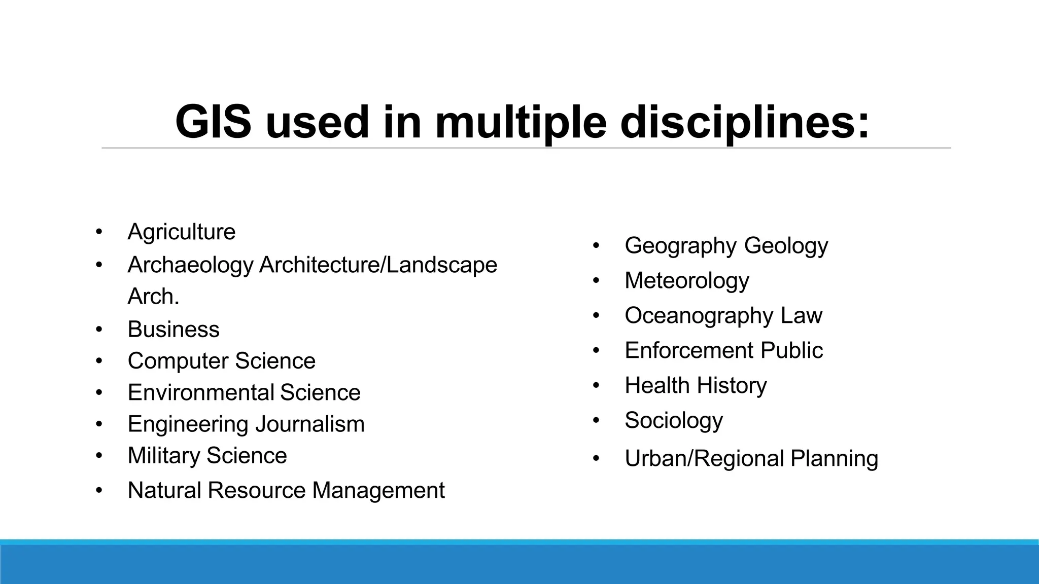
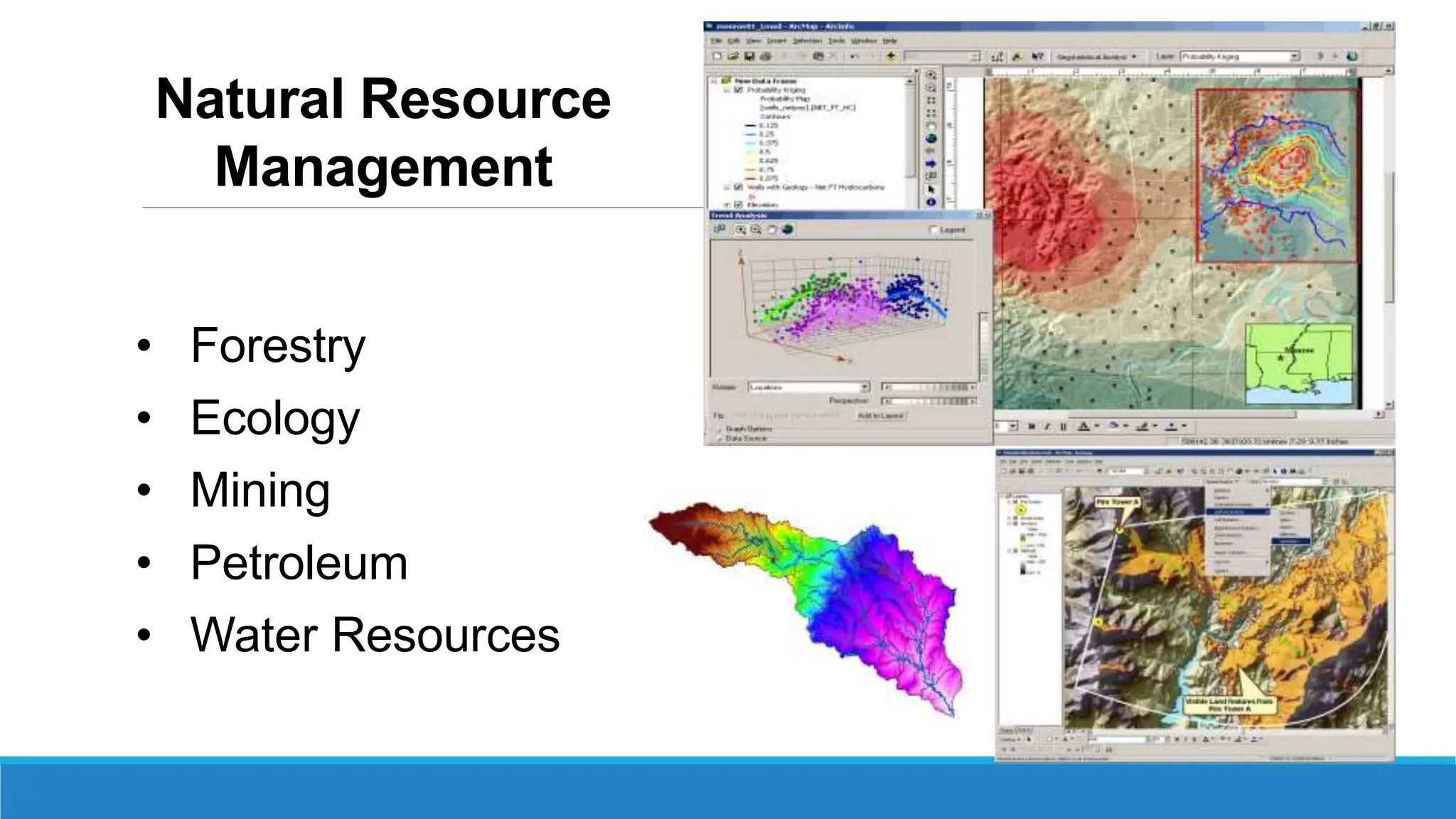
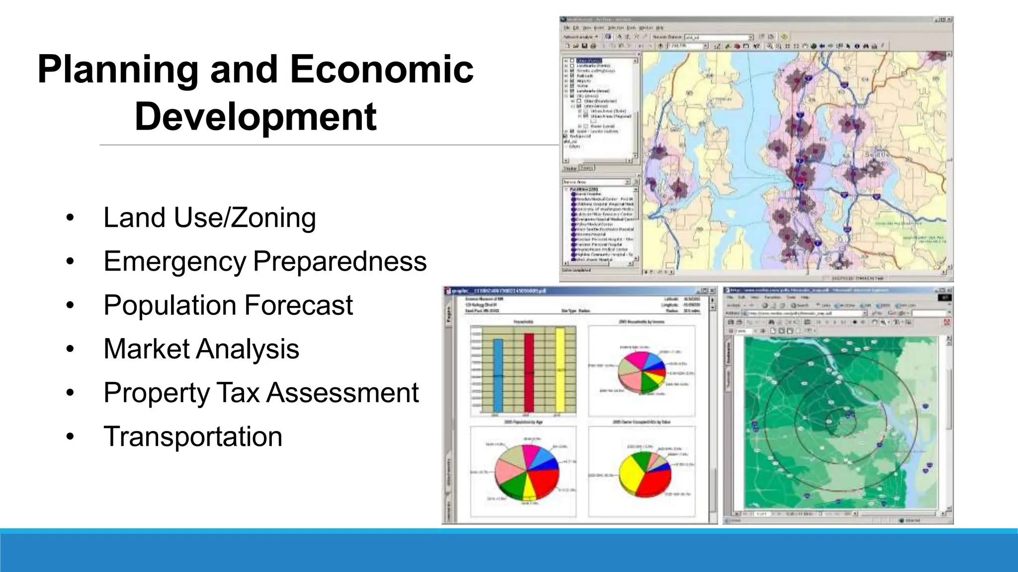
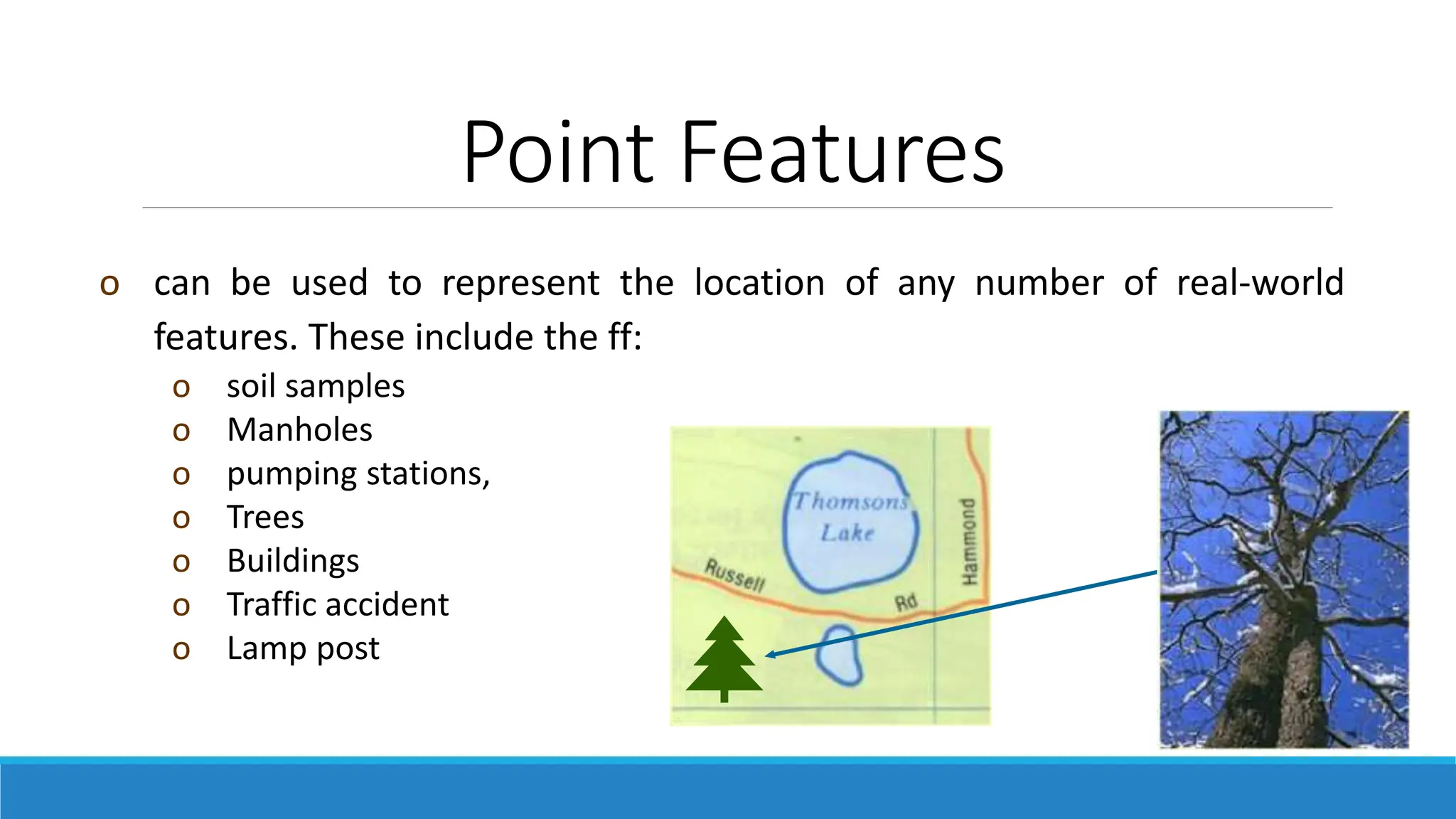
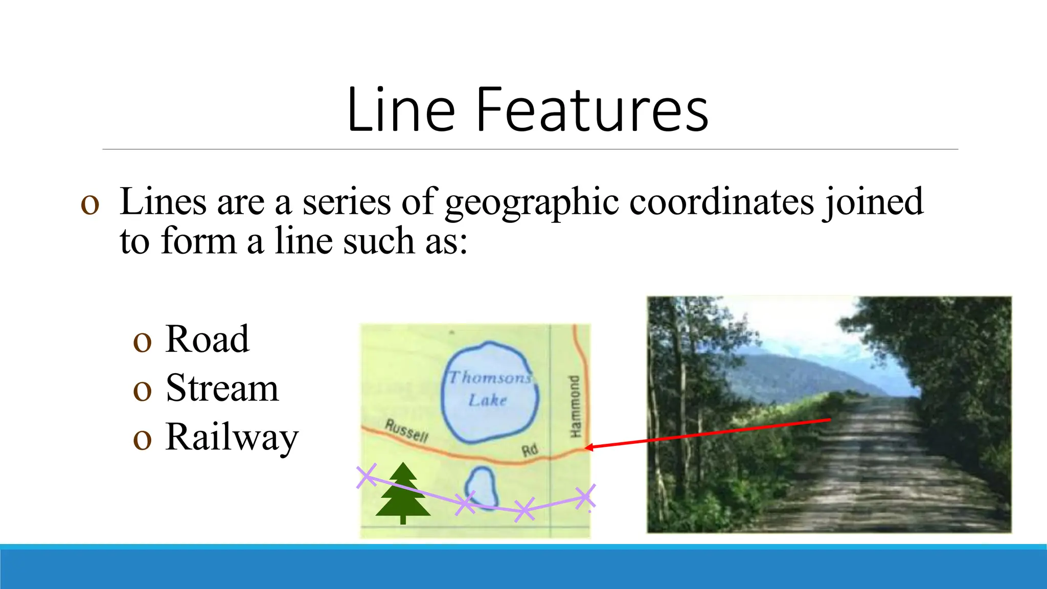
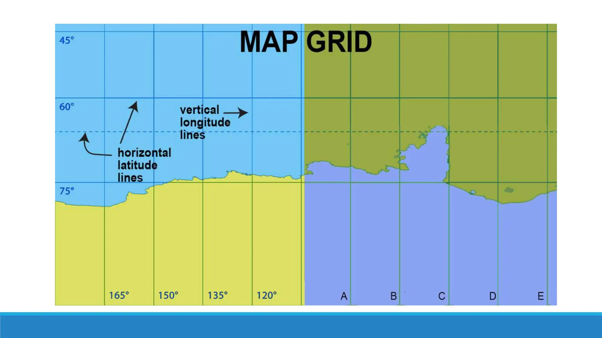
SlideShare a Scribd company logo
1 of 44
GEOGRAPHIC INFORMATION
SYSTEM
Learning outcomes
1. GIS Disciplines
2. Understand why geography matters
3. Location- allocation
4. Mapping Concepts
5. Parts of maps
GIS used in multiple disciplines:
• Agriculture
• Archaeology Architecture/Landscape
Arch.
• Business
• Computer Science
• Environmental Science
• Engineering Journalism
• Military Science
• Natural Resource Management
• Geography Geology
• Meteorology
• Oceanography Law
• Enforcement Public
• Health History
• Sociology
• Urban/Regional Planning
Agriculture
• Farm management
• Pest/Disease tracking
• Crop monitoring
• Yield prediction
• Soil analysis
Natural Resource
Management
• Forestry
• Ecology
• Mining
• Petroleum
• Water Resources
Planning and Economic
Development
• Land Use/Zoning
• Emergency Preparedness
• Population Forecast
• Market Analysis
• Property Tax Assessment
• Transportation
Geography matters
Today’s challenges require geographic approach. Location matters for
understanding a wide variety of processes and phenomena. It helps us to have
an awareness of a place. All places and spaces have a history behind them,
shaped by humans, earth, and climate.
• Climate Change
• Urban Growth
• Sustainable Agriculture Water Quality and Availability
• International and National Security
• Energy
• Epidemiology/Disease Tracking
• Natural Hazards: Seismicity, Weather Events
Location- Allocation
• Finding a subset of locations from a set of potential or
candidate locations that best serve some existing
demand so as minimize some cost
• Locate sites to best serve allocated demand
• Application areas are warehouse location, fast
food locations, fire stations and schools.
Location- Allocation Inputs
• Customer or demand locations
• Potential site locations and/or existing facilities
• Street network
• The problem to solve
Location- Allocation Outputs
• The best sites
• The optimal allocation of demand locations to those
sites
• Lots of statistical and summary information about that
particular allocation
Maps and Maps Elements
Mapping Concepts
A map is a two-dimensional representation of
earth surface which uses graphics to convey
geographical information. It describes the
geographical location of features and the relationship
between them.
Mapping Concepts
Maps provide two types of information
o Locational information - means and include the geo-information obtained
through GPS or other means, such as the geographical location of the User and
sensor data from the device on which you access the Services.
o Spatial Relationships - explore the concept of where objects are in relationship
to something else. For example, a ball may be behind the chair, or under the
table, or in the box. The dog may be on the blanket, outside of the house, or in
the doghouse.
Mapping Concepts
Maps contain POINT, LINE and AREA features
• Point Features : wells, control points, sample sites, fire
stations
• Line Features : roads, hydro lines, rivers, contour lines.
• Area Features: urban areas, water bodies, soil/rock units,
forest areas
Point Features
o can be used to represent the location of any number of real-world
features. These include the ff:
o soil samples
o Manholes
o pumping stations,
o Trees
o Buildings
o Traffic accident
o Lamp post
Points
Examples: Wells, sample sites, huts, schools, clinics
Line Features
o Lines are a series of geographic coordinates joined
to form a line such as:
o Road
o Stream
o Railway
Lines
Examples: Roads, rivers, powerlines, faults
Simple
Complex
Curves
Networks
Area Features
o Areas (Polygons) are a series of geographic coordinates
joined together to form a boundary such as:
o Lake
o Farm
o Forest
o Soil types
Polygons
5 Basic parts of any maps
Every map is unique, but most have at least five main
components in common:
1. Map Title or Heading
2. Map Key or Legend
3. Scale Indicator
4. Grid
5. Compass Rose or North Arrow
Map of the Philippines
Map Title or Heading
The title, also called the heading, of a map is
typically found at the top of the map. It tells you
exactly what the map is showing. The title will be in
a large font and describe in detail what the map is
for.
Map Key or Legend
All the map symbols are defined in the map key, or map legend.
The terms “key” and “legend” are often used interchangeably,
but some maps have both a key and a legend. In these instances,
the key includes the symbols while the legend includes things
like the scale and compass rose.
The symbols on a map make it easier to read because the map is
not crowded with words. The key is usually off to the side of the
map and tells you what each symbol stands for.
Map Key or Legend
Map Key Symbols
When making a map, Cartographers (map makers)
cannot write out everything and make it fit. They
need quick, simple drawings, called map symbols,
to replace written information. If you do not know
what ⋅⋅, ∘∘, or ⊙⊙ means, you cannot understand
the map.
Map Key Symbols
A map key tells you what all the symbols on the
map mean. For example, the small black dot, ⋅⋅,
means a town or village, the open circle, ∘∘, means
a city of at least 75,000 people or that ⊙⊙ means
a state capital. A map key can tell you that ★
usually shows a country’s capital.
Map Key Symbols
Every map uses its own map symbols, depending
on the information the cartographer wants to show.
Map keys can show symbols for natural resources,
population centers, bodies of water, types of
industry, and much more.
Map Key
Map Key Example
Map Key Example
Scale Indicator
The size of earth is too big to be represented as it is on a map. To
represent the whole earth or part thereof on a small map, the concept
of scale is used.
Representation of Scale:
1. Statement: Expressed in words such as ‘1 centimeter to the
kilometer’ which means one centimeter on the map represents one
kilometer on the ground.
2. Representative fraction: It is expressed in fraction. If the scale is
1:50000, it means that 1 unit of measurement on map
represents 50,000 units on ground. It is also known as
numerical scale.
3. Graphic: The scale is shown in form of a strip, where the strip is
divided into a number of equal parts and is marked to show what
these divisions represent on actual ground. It is also known as
plain scale or linear scale.
Scale Indicator
Scale Indicator
Grid
A map’s grid is a series of imaginary horizontal and
vertical lines drawn onto the map. These lines may
represent actual latitudes and longitudes or they may just
split the map into smaller parts. Grid lines will be labeled
at one end or each end.
Grid
Compass Rose or North Arrow
A compass rose is a symbol on a map
that shows the cardinal directions. The
cardinal directions are the main compass
points—north, south, east, and west.
Sometimes it tells the intermediate or
ordinal directions, too: northeast,
southwest, northwest, southwest.
The orientation of a map is important to know, so a tool
that shows you the cardinal directions, or at least which
way is north, is included on most maps. You may see
an arrow labeled “N” for north, or you may see a
compass rose. A compass rose looks like a big star and
shows north, south, east, and west.
Compass Rose or North Arrow
Compass vs. Compass Rose
A compass is a tool that can tell you what direction
you are going, and a compass rose is a drawing on
a map that tells you the directions of places shown
on the map.
Compass Rose
On maps and nautical charts dealing with tides,
sailing, and coastlines, the compass rose is also
called a "windrose" or "rose of the winds."
Other Common Parts of a Map
Because each map is unique, it’s hard to identify
the basic parts that appear on every single map.
You may see examples of the three main parts of a
map or even five, six, or eight main components of
a map.
Additional common map parts include:
• border or neatline - a thick line showing where the map stops
• map credits - information about who made the map, when it
was made, or the data was used to make it
• locator map or inset - a zoomed in or zoomed out view of an
area represented on the map
Geographic  Information System(GIS).pptx

More Related Content

Similar to Geographic Information System(GIS).pptx

Similar to Geographic Information System(GIS).pptx (20)

Map reading
Map readingMap reading
Map reading
 
Chapter 3 gateway 123 combined
Chapter 3 gateway 123 combinedChapter 3 gateway 123 combined
Chapter 3 gateway 123 combined
 
Chapter 1, Section 2
Chapter 1, Section 2Chapter 1, Section 2
Chapter 1, Section 2
 
Maps, cartography and significances
Maps, cartography and significancesMaps, cartography and significances
Maps, cartography and significances
 
The Mapping Skills
The Mapping SkillsThe Mapping Skills
The Mapping Skills
 
Unit I - Introduction to Maps.pptx
Unit I - Introduction to Maps.pptxUnit I - Introduction to Maps.pptx
Unit I - Introduction to Maps.pptx
 
Introduction to Maps
Introduction to MapsIntroduction to Maps
Introduction to Maps
 
Geography skills handbook1
Geography skills handbook1Geography skills handbook1
Geography skills handbook1
 
Exploring geography
Exploring geographyExploring geography
Exploring geography
 
Mapping space around us
Mapping space around usMapping space around us
Mapping space around us
 
Chapter 4 maps ppt
Chapter 4 maps pptChapter 4 maps ppt
Chapter 4 maps ppt
 
RebekahHannonMapSkillsTutorial
RebekahHannonMapSkillsTutorialRebekahHannonMapSkillsTutorial
RebekahHannonMapSkillsTutorial
 
reading maps
reading mapsreading maps
reading maps
 
Practical work in geography
Practical work in geographyPractical work in geography
Practical work in geography
 
Maps and location
Maps and locationMaps and location
Maps and location
 
Unit 2 Elements of a map.pdf
Unit 2 Elements of a map.pdfUnit 2 Elements of a map.pdf
Unit 2 Elements of a map.pdf
 
Chapter 3 gateway 123
Chapter 3 gateway 123Chapter 3 gateway 123
Chapter 3 gateway 123
 
The language of maps
The language of mapsThe language of maps
The language of maps
 
The language of maps
The language of mapsThe language of maps
The language of maps
 
Exploring geographic world
Exploring geographic worldExploring geographic world
Exploring geographic world
 

More from EllenGracePorras

Lesson 3 Introduction to Human Computer Interaction.pptx
Lesson 3 Introduction to Human Computer Interaction.pptxLesson 3 Introduction to Human Computer Interaction.pptx
Lesson 3 Introduction to Human Computer Interaction.pptxEllenGracePorras
 
Lesson 4 Introduction to Human Computer Interaction.pptx
Lesson 4 Introduction to Human Computer Interaction.pptxLesson 4 Introduction to Human Computer Interaction.pptx
Lesson 4 Introduction to Human Computer Interaction.pptxEllenGracePorras
 
Geographic Information Systems (GIS).pptx
Geographic  Information Systems (GIS).pptxGeographic  Information Systems (GIS).pptx
Geographic Information Systems (GIS).pptxEllenGracePorras
 
Advanced Database Systems.pptx
Advanced Database Systems.pptxAdvanced Database Systems.pptx
Advanced Database Systems.pptxEllenGracePorras
 
Data Manipulation Language.pptx
Data Manipulation Language.pptxData Manipulation Language.pptx
Data Manipulation Language.pptxEllenGracePorras
 
Advanced Database Systems - Presentation 4.pptx
Advanced Database Systems - Presentation 4.pptxAdvanced Database Systems - Presentation 4.pptx
Advanced Database Systems - Presentation 4.pptxEllenGracePorras
 
Advanced Database Systems - Presentation 3.pptx
Advanced Database Systems - Presentation 3.pptxAdvanced Database Systems - Presentation 3.pptx
Advanced Database Systems - Presentation 3.pptxEllenGracePorras
 
Advanced Database Systems - Presentation 2.pptx
Advanced Database Systems - Presentation 2.pptxAdvanced Database Systems - Presentation 2.pptx
Advanced Database Systems - Presentation 2.pptxEllenGracePorras
 
Advanced Database Systems - Presentation 1 with quiz.pptx
Advanced Database Systems - Presentation 1 with quiz.pptxAdvanced Database Systems - Presentation 1 with quiz.pptx
Advanced Database Systems - Presentation 1 with quiz.pptxEllenGracePorras
 
Structured Query Language (SQL) Part 2.pptx
Structured Query Language (SQL) Part 2.pptxStructured Query Language (SQL) Part 2.pptx
Structured Query Language (SQL) Part 2.pptxEllenGracePorras
 
.Net Technologies Lesson 1.pptx
.Net Technologies Lesson 1.pptx.Net Technologies Lesson 1.pptx
.Net Technologies Lesson 1.pptxEllenGracePorras
 
Structured Query Language (SQL).pptx
Structured Query Language (SQL).pptxStructured Query Language (SQL).pptx
Structured Query Language (SQL).pptxEllenGracePorras
 

More from EllenGracePorras (18)

Lesson 3 Introduction to Human Computer Interaction.pptx
Lesson 3 Introduction to Human Computer Interaction.pptxLesson 3 Introduction to Human Computer Interaction.pptx
Lesson 3 Introduction to Human Computer Interaction.pptx
 
Lesson 4 Introduction to Human Computer Interaction.pptx
Lesson 4 Introduction to Human Computer Interaction.pptxLesson 4 Introduction to Human Computer Interaction.pptx
Lesson 4 Introduction to Human Computer Interaction.pptx
 
Geographic Information Systems (GIS).pptx
Geographic  Information Systems (GIS).pptxGeographic  Information Systems (GIS).pptx
Geographic Information Systems (GIS).pptx
 
Advanced Database Systems.pptx
Advanced Database Systems.pptxAdvanced Database Systems.pptx
Advanced Database Systems.pptx
 
Data Manipulation Language.pptx
Data Manipulation Language.pptxData Manipulation Language.pptx
Data Manipulation Language.pptx
 
Advanced Database Systems - Presentation 4.pptx
Advanced Database Systems - Presentation 4.pptxAdvanced Database Systems - Presentation 4.pptx
Advanced Database Systems - Presentation 4.pptx
 
Advanced Database Systems - Presentation 3.pptx
Advanced Database Systems - Presentation 3.pptxAdvanced Database Systems - Presentation 3.pptx
Advanced Database Systems - Presentation 3.pptx
 
Advanced Database Systems - Presentation 2.pptx
Advanced Database Systems - Presentation 2.pptxAdvanced Database Systems - Presentation 2.pptx
Advanced Database Systems - Presentation 2.pptx
 
Advanced Database Systems - Presentation 1 with quiz.pptx
Advanced Database Systems - Presentation 1 with quiz.pptxAdvanced Database Systems - Presentation 1 with quiz.pptx
Advanced Database Systems - Presentation 1 with quiz.pptx
 
Structured Query Language (SQL) Part 2.pptx
Structured Query Language (SQL) Part 2.pptxStructured Query Language (SQL) Part 2.pptx
Structured Query Language (SQL) Part 2.pptx
 
SQL Where Clause.pptx
SQL Where Clause.pptxSQL Where Clause.pptx
SQL Where Clause.pptx
 
SQL Statements.pptx
SQL Statements.pptxSQL Statements.pptx
SQL Statements.pptx
 
Information Management
Information ManagementInformation Management
Information Management
 
Lesson 2 HCI 2.pptx
Lesson 2 HCI 2.pptxLesson 2 HCI 2.pptx
Lesson 2 HCI 2.pptx
 
Lesson 2 HCI 2.pdf
Lesson 2 HCI 2.pdfLesson 2 HCI 2.pdf
Lesson 2 HCI 2.pdf
 
.Net Technologies Lesson 1.pptx
.Net Technologies Lesson 1.pptx.Net Technologies Lesson 1.pptx
.Net Technologies Lesson 1.pptx
 
CC 1/L Introduction.pptx
CC 1/L Introduction.pptxCC 1/L Introduction.pptx
CC 1/L Introduction.pptx
 
Structured Query Language (SQL).pptx
Structured Query Language (SQL).pptxStructured Query Language (SQL).pptx
Structured Query Language (SQL).pptx
 

Recently uploaded

Human Factors of XR: Using Human Factors to Design XR Systems
Human Factors of XR: Using Human Factors to Design XR SystemsHuman Factors of XR: Using Human Factors to Design XR Systems
Human Factors of XR: Using Human Factors to Design XR SystemsMark Billinghurst
 
Bun (KitWorks Team Study 노별마루 발표 2024.4.22)
Bun (KitWorks Team Study 노별마루 발표 2024.4.22)Bun (KitWorks Team Study 노별마루 발표 2024.4.22)
Bun (KitWorks Team Study 노별마루 발표 2024.4.22)Wonjun Hwang
 
"Federated learning: out of reach no matter how close",Oleksandr Lapshyn
"Federated learning: out of reach no matter how close",Oleksandr Lapshyn"Federated learning: out of reach no matter how close",Oleksandr Lapshyn
"Federated learning: out of reach no matter how close",Oleksandr LapshynFwdays
 
Advanced Test Driven-Development @ php[tek] 2024
Advanced Test Driven-Development @ php[tek] 2024Advanced Test Driven-Development @ php[tek] 2024
Advanced Test Driven-Development @ php[tek] 2024Scott Keck-Warren
 
WordPress Websites for Engineers: Elevate Your Brand
WordPress Websites for Engineers: Elevate Your BrandWordPress Websites for Engineers: Elevate Your Brand
WordPress Websites for Engineers: Elevate Your Brandgvaughan
 
CloudStudio User manual (basic edition):
CloudStudio User manual (basic edition):CloudStudio User manual (basic edition):
CloudStudio User manual (basic edition):comworks
 
Benefits Of Flutter Compared To Other Frameworks
Benefits Of Flutter Compared To Other FrameworksBenefits Of Flutter Compared To Other Frameworks
Benefits Of Flutter Compared To Other FrameworksSoftradix Technologies
 
AI as an Interface for Commercial Buildings
AI as an Interface for Commercial BuildingsAI as an Interface for Commercial Buildings
AI as an Interface for Commercial BuildingsMemoori
 
Unblocking The Main Thread Solving ANRs and Frozen Frames
Unblocking The Main Thread Solving ANRs and Frozen FramesUnblocking The Main Thread Solving ANRs and Frozen Frames
Unblocking The Main Thread Solving ANRs and Frozen FramesSinan KOZAK
 
New from BookNet Canada for 2024: BNC BiblioShare - Tech Forum 2024
New from BookNet Canada for 2024: BNC BiblioShare - Tech Forum 2024New from BookNet Canada for 2024: BNC BiblioShare - Tech Forum 2024
New from BookNet Canada for 2024: BNC BiblioShare - Tech Forum 2024BookNet Canada
 
Tampa BSides - Chef's Tour of Microsoft Security Adoption Framework (SAF)
Tampa BSides - Chef's Tour of Microsoft Security Adoption Framework (SAF)Tampa BSides - Chef's Tour of Microsoft Security Adoption Framework (SAF)
Tampa BSides - Chef's Tour of Microsoft Security Adoption Framework (SAF)Mark Simos
 
Tech-Forward - Achieving Business Readiness For Copilot in Microsoft 365
Tech-Forward - Achieving Business Readiness For Copilot in Microsoft 365Tech-Forward - Achieving Business Readiness For Copilot in Microsoft 365
Tech-Forward - Achieving Business Readiness For Copilot in Microsoft 3652toLead Limited
 
Integration and Automation in Practice: CI/CD in Mule Integration and Automat...
Integration and Automation in Practice: CI/CD in Mule Integration and Automat...Integration and Automation in Practice: CI/CD in Mule Integration and Automat...
Integration and Automation in Practice: CI/CD in Mule Integration and Automat...Patryk Bandurski
 
Nell’iperspazio con Rocket: il Framework Web di Rust!
Nell’iperspazio con Rocket: il Framework Web di Rust!Nell’iperspazio con Rocket: il Framework Web di Rust!
Nell’iperspazio con Rocket: il Framework Web di Rust!Commit University
 
"ML in Production",Oleksandr Bagan
"ML in Production",Oleksandr Bagan"ML in Production",Oleksandr Bagan
"ML in Production",Oleksandr BaganFwdays
 
My Hashitalk Indonesia April 2024 Presentation
My Hashitalk Indonesia April 2024 PresentationMy Hashitalk Indonesia April 2024 Presentation
My Hashitalk Indonesia April 2024 PresentationRidwan Fadjar
 
Automating Business Process via MuleSoft Composer | Bangalore MuleSoft Meetup...
Automating Business Process via MuleSoft Composer | Bangalore MuleSoft Meetup...Automating Business Process via MuleSoft Composer | Bangalore MuleSoft Meetup...
Automating Business Process via MuleSoft Composer | Bangalore MuleSoft Meetup...shyamraj55
 
Connect Wave/ connectwave Pitch Deck Presentation
Connect Wave/ connectwave Pitch Deck PresentationConnect Wave/ connectwave Pitch Deck Presentation
Connect Wave/ connectwave Pitch Deck PresentationSlibray Presentation
 

Recently uploaded (20)

Hot Sexy call girls in Panjabi Bagh 🔝 9953056974 🔝 Delhi escort Service
Hot Sexy call girls in Panjabi Bagh 🔝 9953056974 🔝 Delhi escort ServiceHot Sexy call girls in Panjabi Bagh 🔝 9953056974 🔝 Delhi escort Service
Hot Sexy call girls in Panjabi Bagh 🔝 9953056974 🔝 Delhi escort Service
 
Human Factors of XR: Using Human Factors to Design XR Systems
Human Factors of XR: Using Human Factors to Design XR SystemsHuman Factors of XR: Using Human Factors to Design XR Systems
Human Factors of XR: Using Human Factors to Design XR Systems
 
Bun (KitWorks Team Study 노별마루 발표 2024.4.22)
Bun (KitWorks Team Study 노별마루 발표 2024.4.22)Bun (KitWorks Team Study 노별마루 발표 2024.4.22)
Bun (KitWorks Team Study 노별마루 발표 2024.4.22)
 
"Federated learning: out of reach no matter how close",Oleksandr Lapshyn
"Federated learning: out of reach no matter how close",Oleksandr Lapshyn"Federated learning: out of reach no matter how close",Oleksandr Lapshyn
"Federated learning: out of reach no matter how close",Oleksandr Lapshyn
 
Vulnerability_Management_GRC_by Sohang Sengupta.pptx
Vulnerability_Management_GRC_by Sohang Sengupta.pptxVulnerability_Management_GRC_by Sohang Sengupta.pptx
Vulnerability_Management_GRC_by Sohang Sengupta.pptx
 
Advanced Test Driven-Development @ php[tek] 2024
Advanced Test Driven-Development @ php[tek] 2024Advanced Test Driven-Development @ php[tek] 2024
Advanced Test Driven-Development @ php[tek] 2024
 
WordPress Websites for Engineers: Elevate Your Brand
WordPress Websites for Engineers: Elevate Your BrandWordPress Websites for Engineers: Elevate Your Brand
WordPress Websites for Engineers: Elevate Your Brand
 
CloudStudio User manual (basic edition):
CloudStudio User manual (basic edition):CloudStudio User manual (basic edition):
CloudStudio User manual (basic edition):
 
Benefits Of Flutter Compared To Other Frameworks
Benefits Of Flutter Compared To Other FrameworksBenefits Of Flutter Compared To Other Frameworks
Benefits Of Flutter Compared To Other Frameworks
 
AI as an Interface for Commercial Buildings
AI as an Interface for Commercial BuildingsAI as an Interface for Commercial Buildings
AI as an Interface for Commercial Buildings
 
Unblocking The Main Thread Solving ANRs and Frozen Frames
Unblocking The Main Thread Solving ANRs and Frozen FramesUnblocking The Main Thread Solving ANRs and Frozen Frames
Unblocking The Main Thread Solving ANRs and Frozen Frames
 
New from BookNet Canada for 2024: BNC BiblioShare - Tech Forum 2024
New from BookNet Canada for 2024: BNC BiblioShare - Tech Forum 2024New from BookNet Canada for 2024: BNC BiblioShare - Tech Forum 2024
New from BookNet Canada for 2024: BNC BiblioShare - Tech Forum 2024
 
Tampa BSides - Chef's Tour of Microsoft Security Adoption Framework (SAF)
Tampa BSides - Chef's Tour of Microsoft Security Adoption Framework (SAF)Tampa BSides - Chef's Tour of Microsoft Security Adoption Framework (SAF)
Tampa BSides - Chef's Tour of Microsoft Security Adoption Framework (SAF)
 
Tech-Forward - Achieving Business Readiness For Copilot in Microsoft 365
Tech-Forward - Achieving Business Readiness For Copilot in Microsoft 365Tech-Forward - Achieving Business Readiness For Copilot in Microsoft 365
Tech-Forward - Achieving Business Readiness For Copilot in Microsoft 365
 
Integration and Automation in Practice: CI/CD in Mule Integration and Automat...
Integration and Automation in Practice: CI/CD in Mule Integration and Automat...Integration and Automation in Practice: CI/CD in Mule Integration and Automat...
Integration and Automation in Practice: CI/CD in Mule Integration and Automat...
 
Nell’iperspazio con Rocket: il Framework Web di Rust!
Nell’iperspazio con Rocket: il Framework Web di Rust!Nell’iperspazio con Rocket: il Framework Web di Rust!
Nell’iperspazio con Rocket: il Framework Web di Rust!
 
"ML in Production",Oleksandr Bagan
"ML in Production",Oleksandr Bagan"ML in Production",Oleksandr Bagan
"ML in Production",Oleksandr Bagan
 
My Hashitalk Indonesia April 2024 Presentation
My Hashitalk Indonesia April 2024 PresentationMy Hashitalk Indonesia April 2024 Presentation
My Hashitalk Indonesia April 2024 Presentation
 
Automating Business Process via MuleSoft Composer | Bangalore MuleSoft Meetup...
Automating Business Process via MuleSoft Composer | Bangalore MuleSoft Meetup...Automating Business Process via MuleSoft Composer | Bangalore MuleSoft Meetup...
Automating Business Process via MuleSoft Composer | Bangalore MuleSoft Meetup...
 
Connect Wave/ connectwave Pitch Deck Presentation
Connect Wave/ connectwave Pitch Deck PresentationConnect Wave/ connectwave Pitch Deck Presentation
Connect Wave/ connectwave Pitch Deck Presentation
 

Geographic Information System(GIS).pptx

  • 2. Learning outcomes 1. GIS Disciplines 2. Understand why geography matters 3. Location- allocation 4. Mapping Concepts 5. Parts of maps
  • 3. GIS used in multiple disciplines: • Agriculture • Archaeology Architecture/Landscape Arch. • Business • Computer Science • Environmental Science • Engineering Journalism • Military Science • Natural Resource Management • Geography Geology • Meteorology • Oceanography Law • Enforcement Public • Health History • Sociology • Urban/Regional Planning
  • 4. Agriculture • Farm management • Pest/Disease tracking • Crop monitoring • Yield prediction • Soil analysis
  • 5. Natural Resource Management • Forestry • Ecology • Mining • Petroleum • Water Resources
  • 6. Planning and Economic Development • Land Use/Zoning • Emergency Preparedness • Population Forecast • Market Analysis • Property Tax Assessment • Transportation
  • 7. Geography matters Today’s challenges require geographic approach. Location matters for understanding a wide variety of processes and phenomena. It helps us to have an awareness of a place. All places and spaces have a history behind them, shaped by humans, earth, and climate. • Climate Change • Urban Growth • Sustainable Agriculture Water Quality and Availability • International and National Security • Energy • Epidemiology/Disease Tracking • Natural Hazards: Seismicity, Weather Events
  • 8. Location- Allocation • Finding a subset of locations from a set of potential or candidate locations that best serve some existing demand so as minimize some cost • Locate sites to best serve allocated demand • Application areas are warehouse location, fast food locations, fire stations and schools.
  • 9. Location- Allocation Inputs • Customer or demand locations • Potential site locations and/or existing facilities • Street network • The problem to solve
  • 10. Location- Allocation Outputs • The best sites • The optimal allocation of demand locations to those sites • Lots of statistical and summary information about that particular allocation
  • 11. Maps and Maps Elements
  • 12. Mapping Concepts A map is a two-dimensional representation of earth surface which uses graphics to convey geographical information. It describes the geographical location of features and the relationship between them.
  • 13. Mapping Concepts Maps provide two types of information o Locational information - means and include the geo-information obtained through GPS or other means, such as the geographical location of the User and sensor data from the device on which you access the Services. o Spatial Relationships - explore the concept of where objects are in relationship to something else. For example, a ball may be behind the chair, or under the table, or in the box. The dog may be on the blanket, outside of the house, or in the doghouse.
  • 14. Mapping Concepts Maps contain POINT, LINE and AREA features • Point Features : wells, control points, sample sites, fire stations • Line Features : roads, hydro lines, rivers, contour lines. • Area Features: urban areas, water bodies, soil/rock units, forest areas
  • 15. Point Features o can be used to represent the location of any number of real-world features. These include the ff: o soil samples o Manholes o pumping stations, o Trees o Buildings o Traffic accident o Lamp post
  • 16. Points Examples: Wells, sample sites, huts, schools, clinics
  • 17. Line Features o Lines are a series of geographic coordinates joined to form a line such as: o Road o Stream o Railway
  • 18. Lines Examples: Roads, rivers, powerlines, faults Simple Complex Curves Networks
  • 19. Area Features o Areas (Polygons) are a series of geographic coordinates joined together to form a boundary such as: o Lake o Farm o Forest o Soil types
  • 21. 5 Basic parts of any maps Every map is unique, but most have at least five main components in common: 1. Map Title or Heading 2. Map Key or Legend 3. Scale Indicator 4. Grid 5. Compass Rose or North Arrow
  • 22. Map of the Philippines
  • 23. Map Title or Heading The title, also called the heading, of a map is typically found at the top of the map. It tells you exactly what the map is showing. The title will be in a large font and describe in detail what the map is for.
  • 24. Map Key or Legend All the map symbols are defined in the map key, or map legend. The terms “key” and “legend” are often used interchangeably, but some maps have both a key and a legend. In these instances, the key includes the symbols while the legend includes things like the scale and compass rose.
  • 25. The symbols on a map make it easier to read because the map is not crowded with words. The key is usually off to the side of the map and tells you what each symbol stands for. Map Key or Legend
  • 26. Map Key Symbols When making a map, Cartographers (map makers) cannot write out everything and make it fit. They need quick, simple drawings, called map symbols, to replace written information. If you do not know what ⋅⋅, ∘∘, or ⊙⊙ means, you cannot understand the map.
  • 27. Map Key Symbols A map key tells you what all the symbols on the map mean. For example, the small black dot, ⋅⋅, means a town or village, the open circle, ∘∘, means a city of at least 75,000 people or that ⊙⊙ means a state capital. A map key can tell you that ★ usually shows a country’s capital.
  • 28. Map Key Symbols Every map uses its own map symbols, depending on the information the cartographer wants to show. Map keys can show symbols for natural resources, population centers, bodies of water, types of industry, and much more.
  • 32. Scale Indicator The size of earth is too big to be represented as it is on a map. To represent the whole earth or part thereof on a small map, the concept of scale is used. Representation of Scale: 1. Statement: Expressed in words such as ‘1 centimeter to the kilometer’ which means one centimeter on the map represents one kilometer on the ground.
  • 33. 2. Representative fraction: It is expressed in fraction. If the scale is 1:50000, it means that 1 unit of measurement on map represents 50,000 units on ground. It is also known as numerical scale. 3. Graphic: The scale is shown in form of a strip, where the strip is divided into a number of equal parts and is marked to show what these divisions represent on actual ground. It is also known as plain scale or linear scale. Scale Indicator
  • 35. Grid A map’s grid is a series of imaginary horizontal and vertical lines drawn onto the map. These lines may represent actual latitudes and longitudes or they may just split the map into smaller parts. Grid lines will be labeled at one end or each end.
  • 36. Grid
  • 37. Compass Rose or North Arrow A compass rose is a symbol on a map that shows the cardinal directions. The cardinal directions are the main compass points—north, south, east, and west. Sometimes it tells the intermediate or ordinal directions, too: northeast, southwest, northwest, southwest.
  • 38. The orientation of a map is important to know, so a tool that shows you the cardinal directions, or at least which way is north, is included on most maps. You may see an arrow labeled “N” for north, or you may see a compass rose. A compass rose looks like a big star and shows north, south, east, and west. Compass Rose or North Arrow
  • 39. Compass Rose or North Arrow
  • 40. Compass vs. Compass Rose A compass is a tool that can tell you what direction you are going, and a compass rose is a drawing on a map that tells you the directions of places shown on the map.
  • 41. Compass Rose On maps and nautical charts dealing with tides, sailing, and coastlines, the compass rose is also called a "windrose" or "rose of the winds."
  • 42. Other Common Parts of a Map Because each map is unique, it’s hard to identify the basic parts that appear on every single map. You may see examples of the three main parts of a map or even five, six, or eight main components of a map.
  • 43. Additional common map parts include: • border or neatline - a thick line showing where the map stops • map credits - information about who made the map, when it was made, or the data was used to make it • locator map or inset - a zoomed in or zoomed out view of an area represented on the map