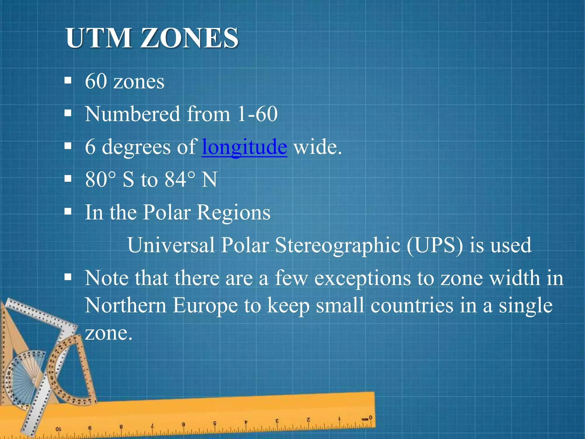
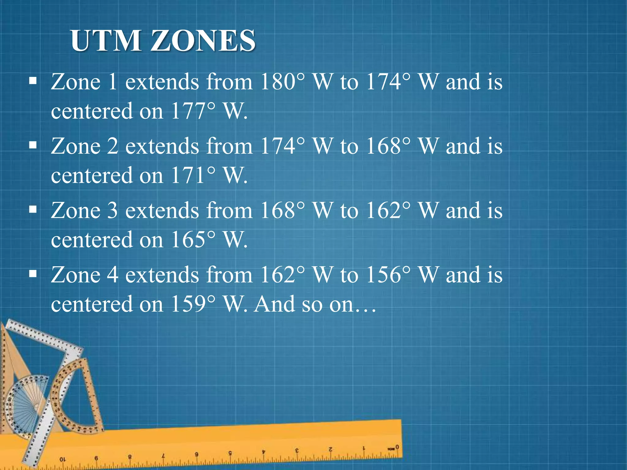
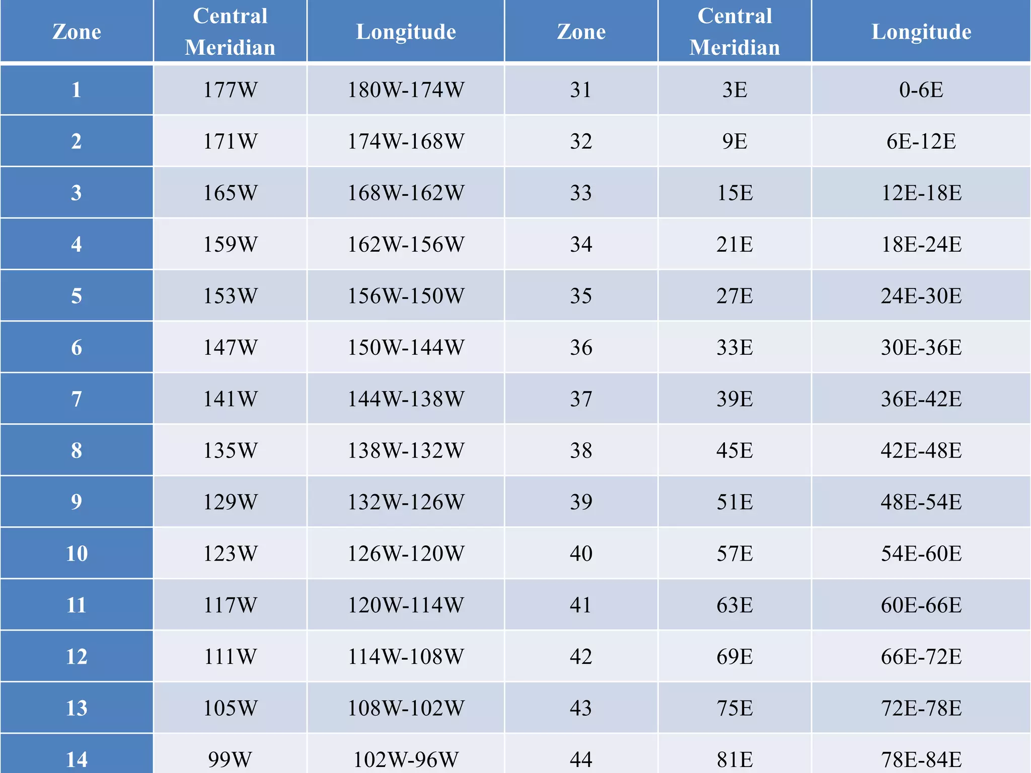
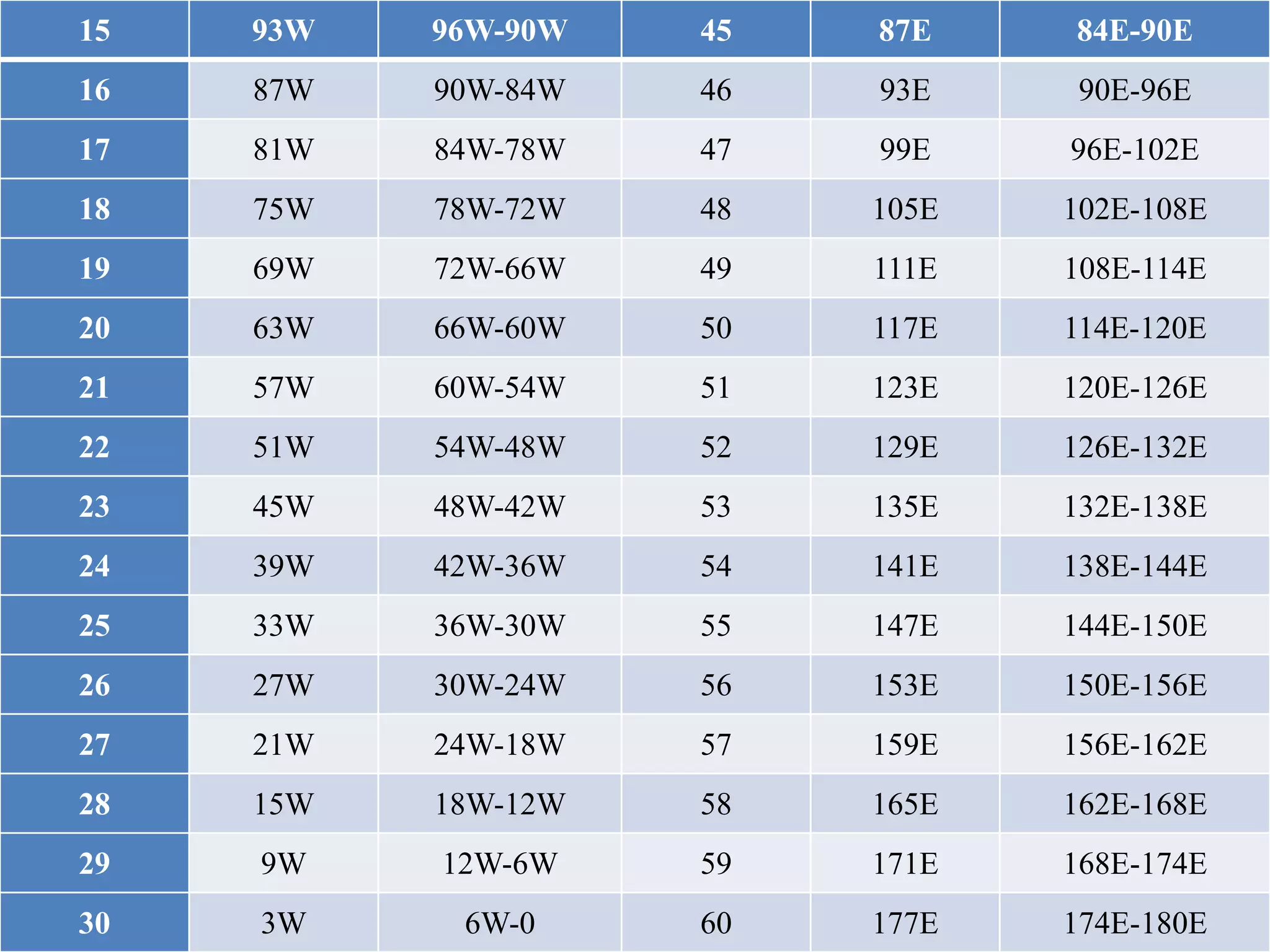
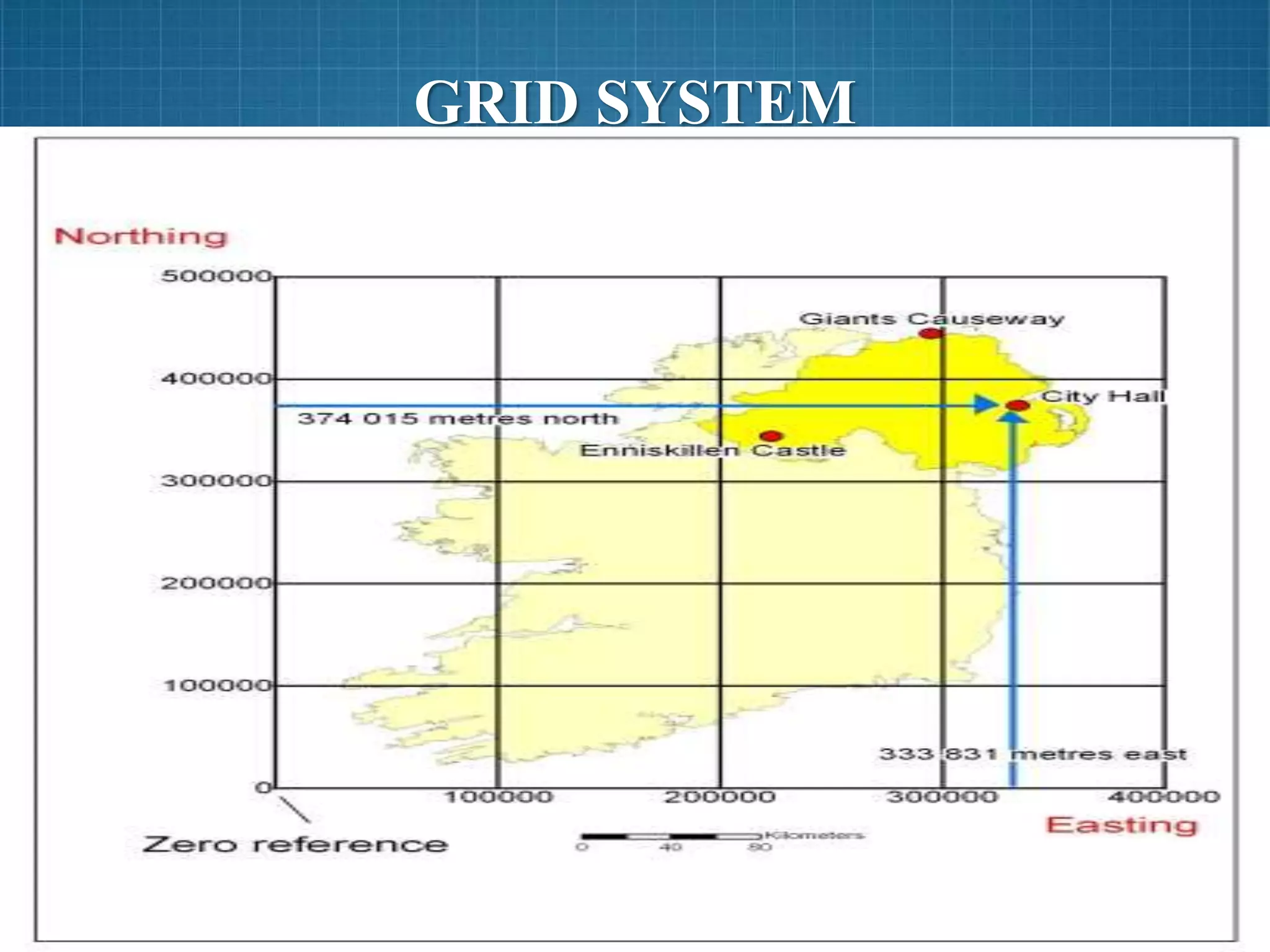
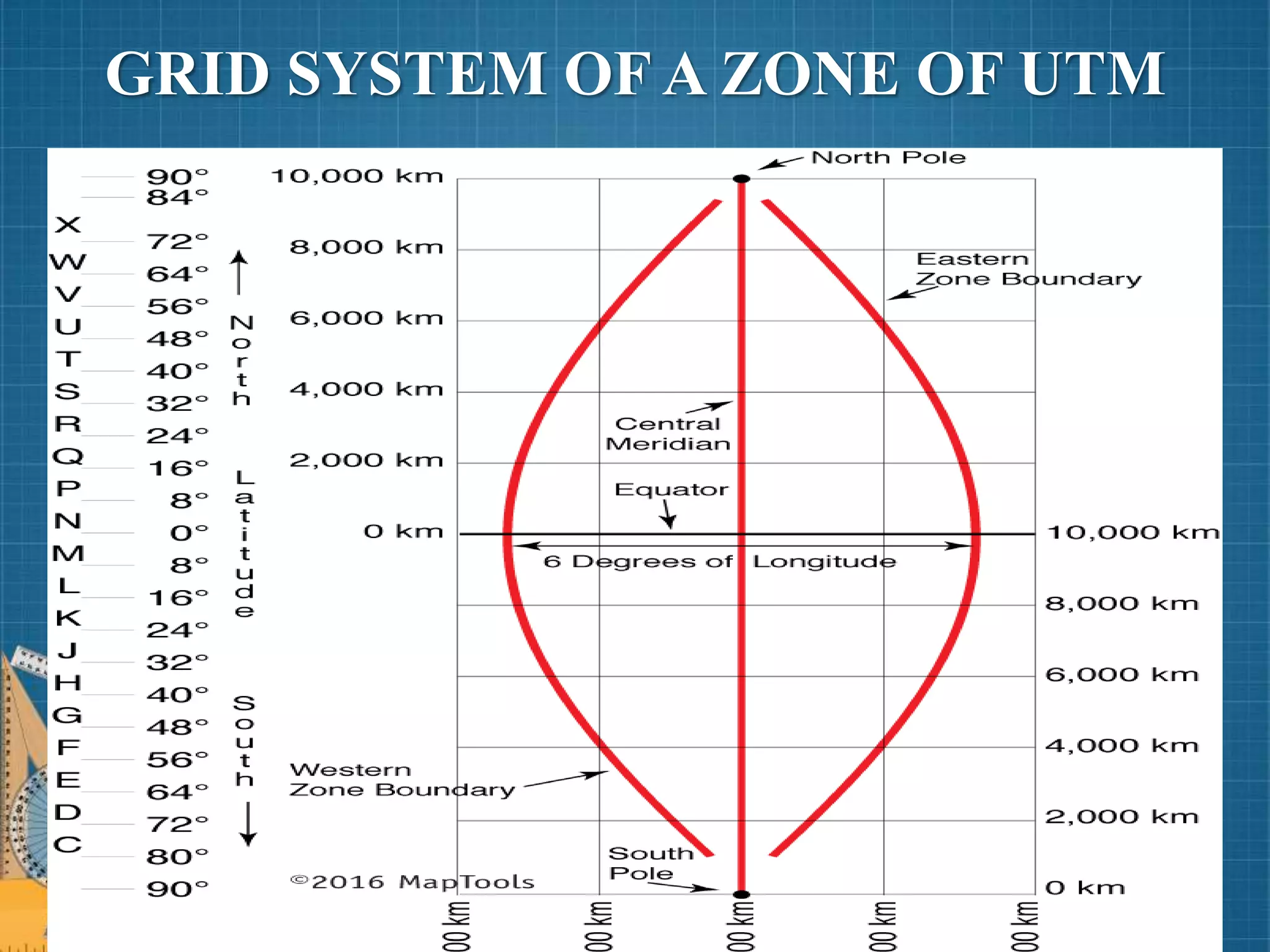
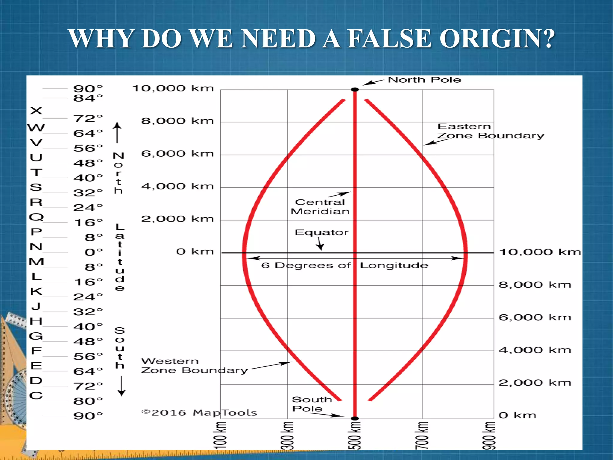
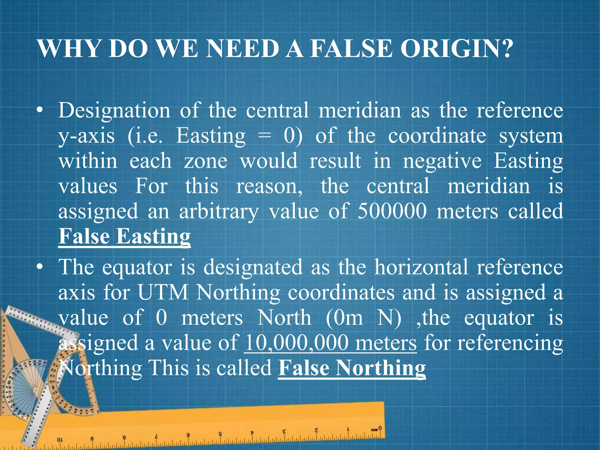
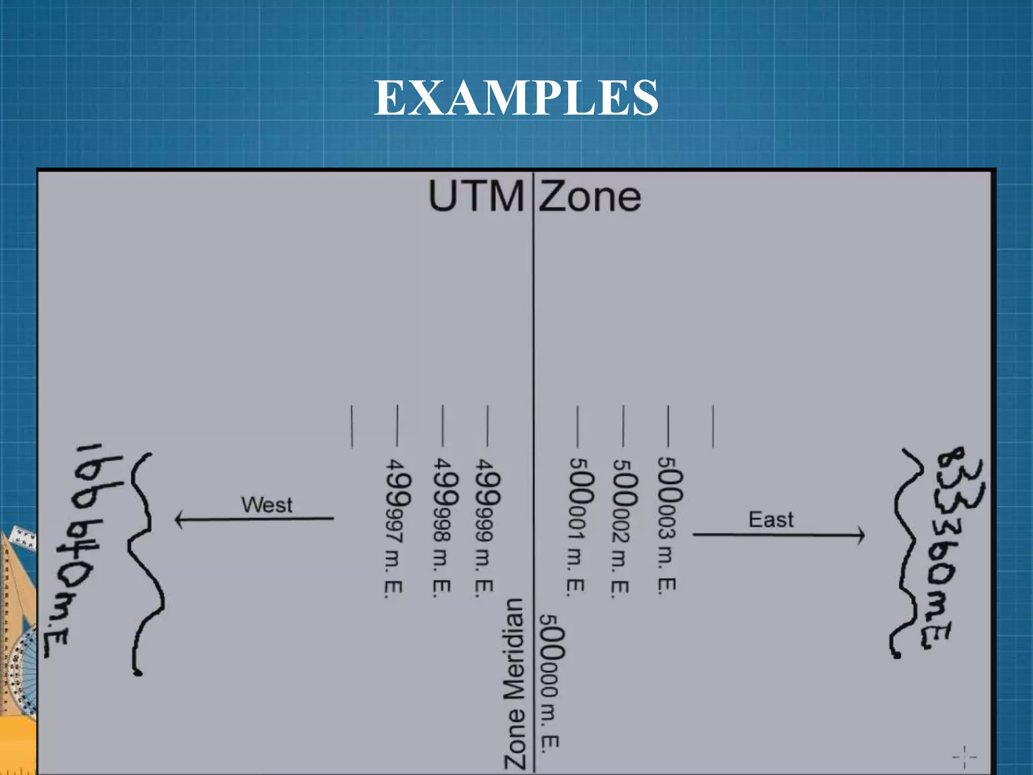
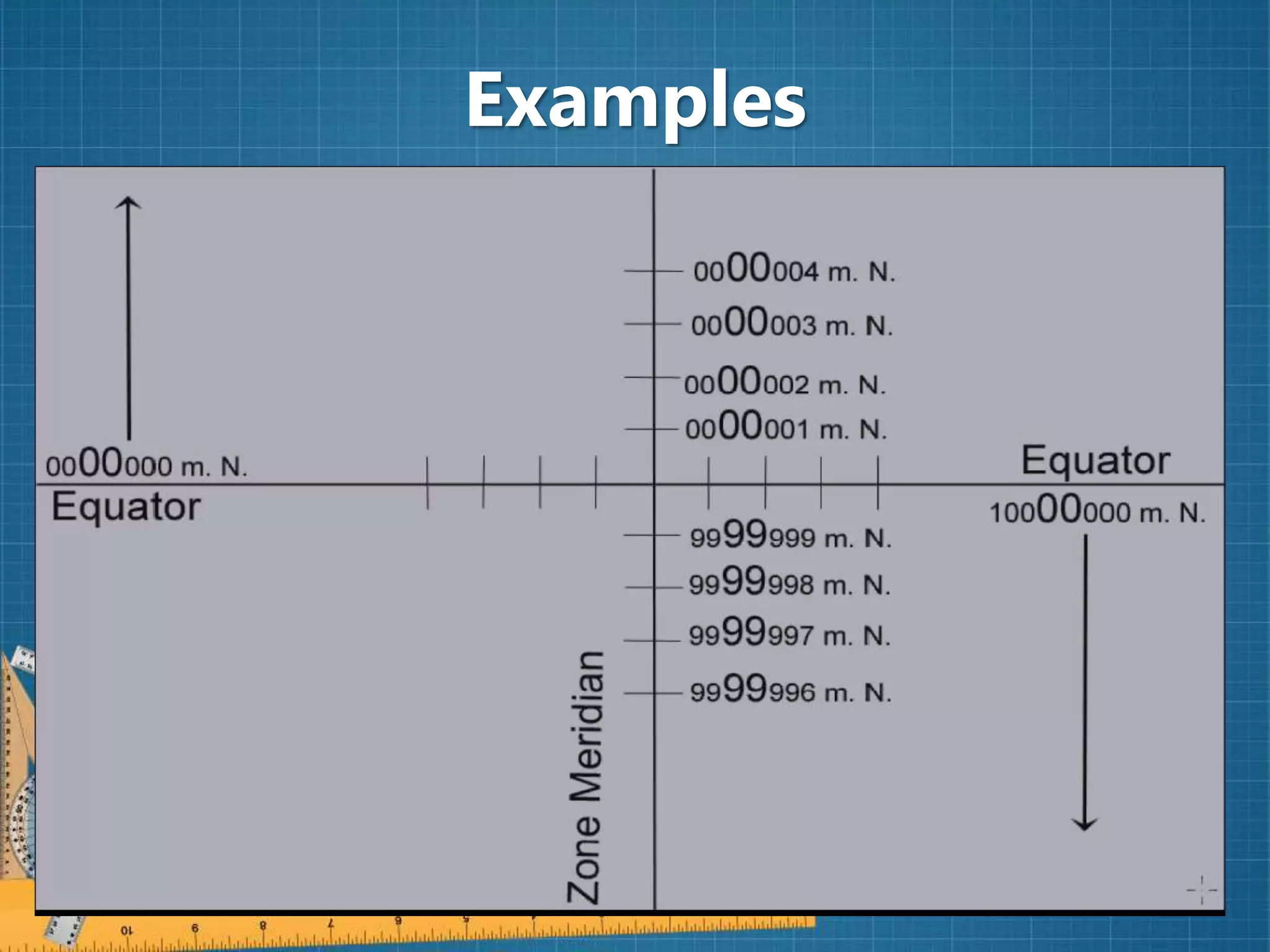
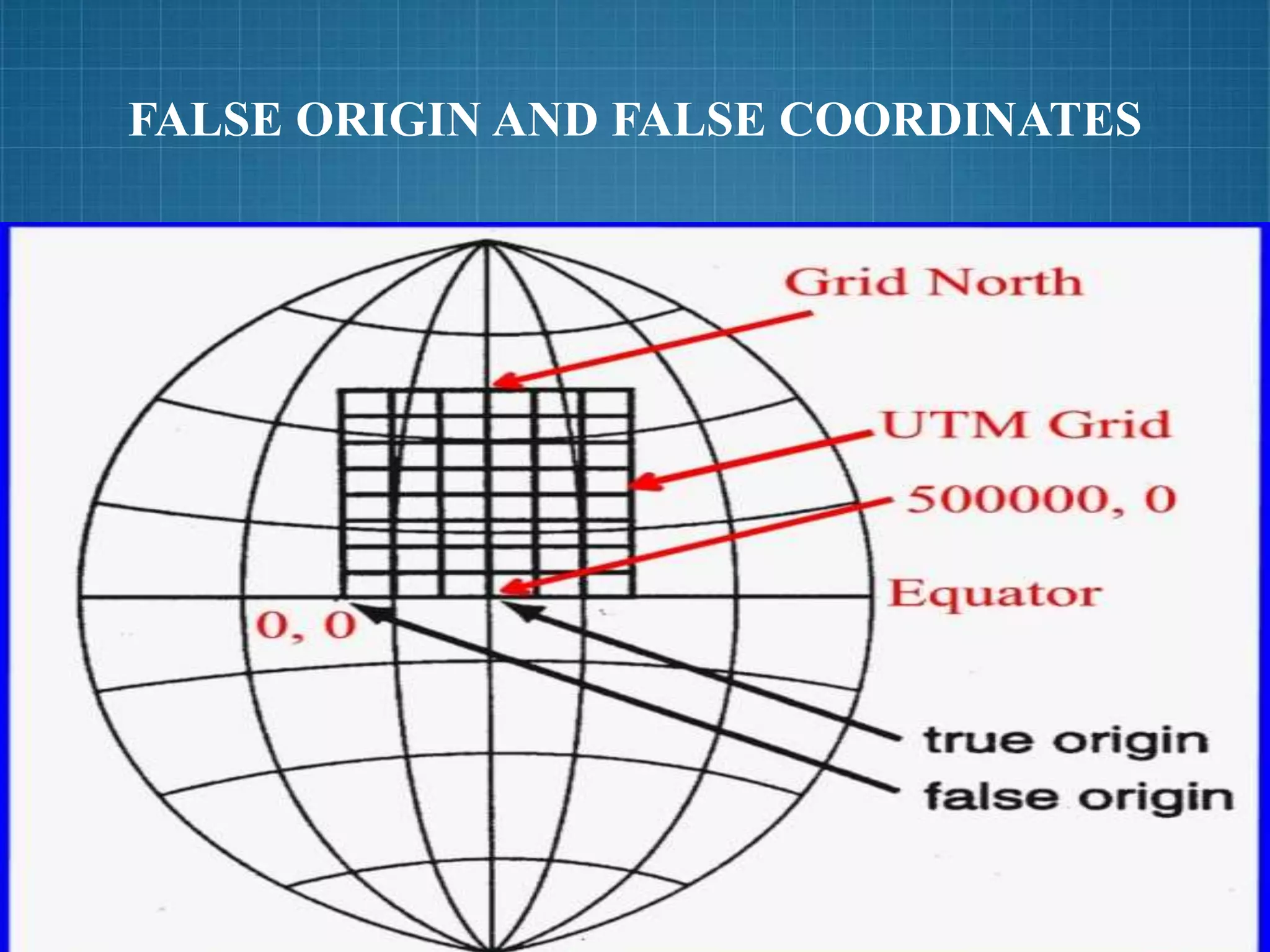
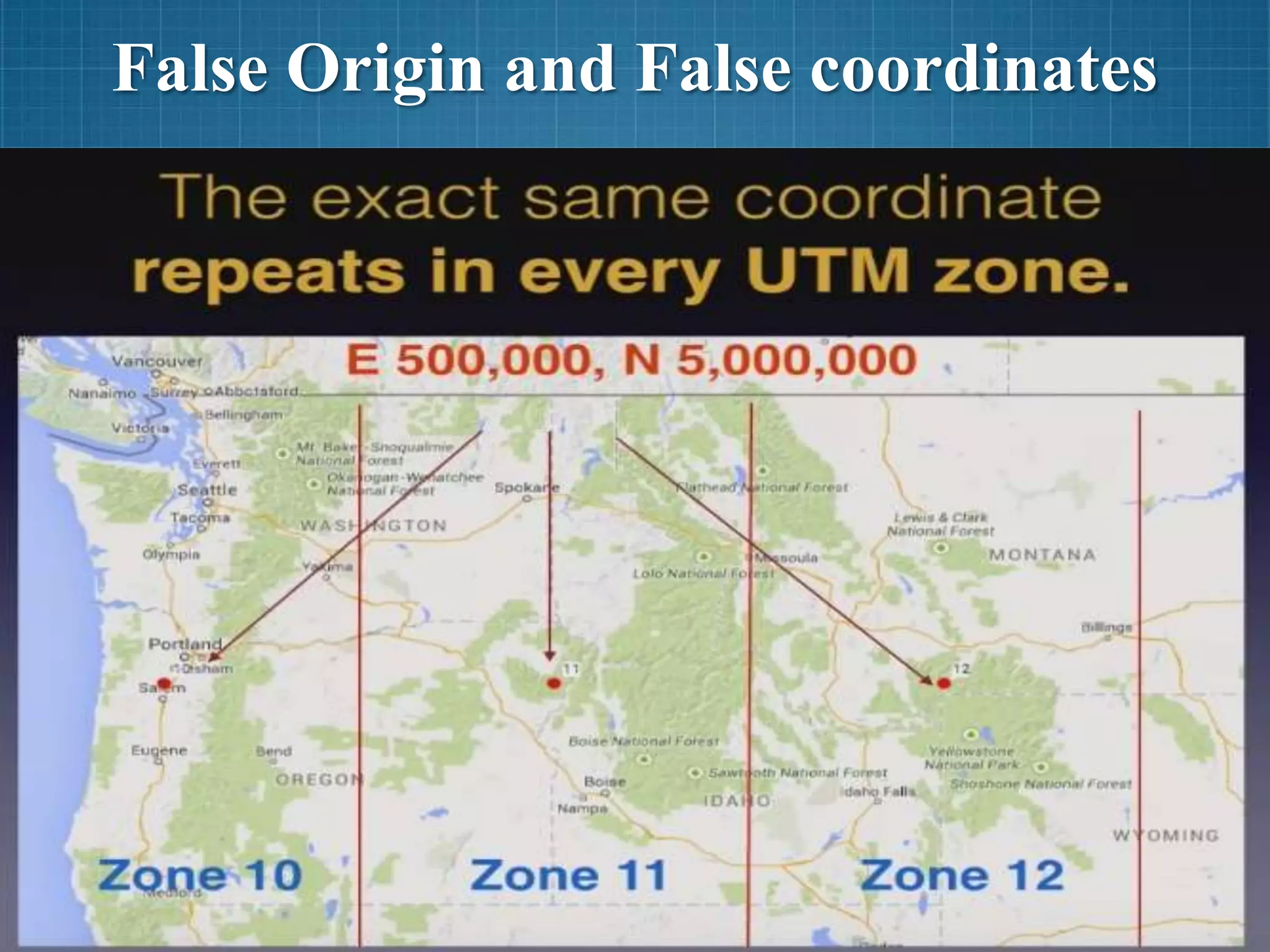
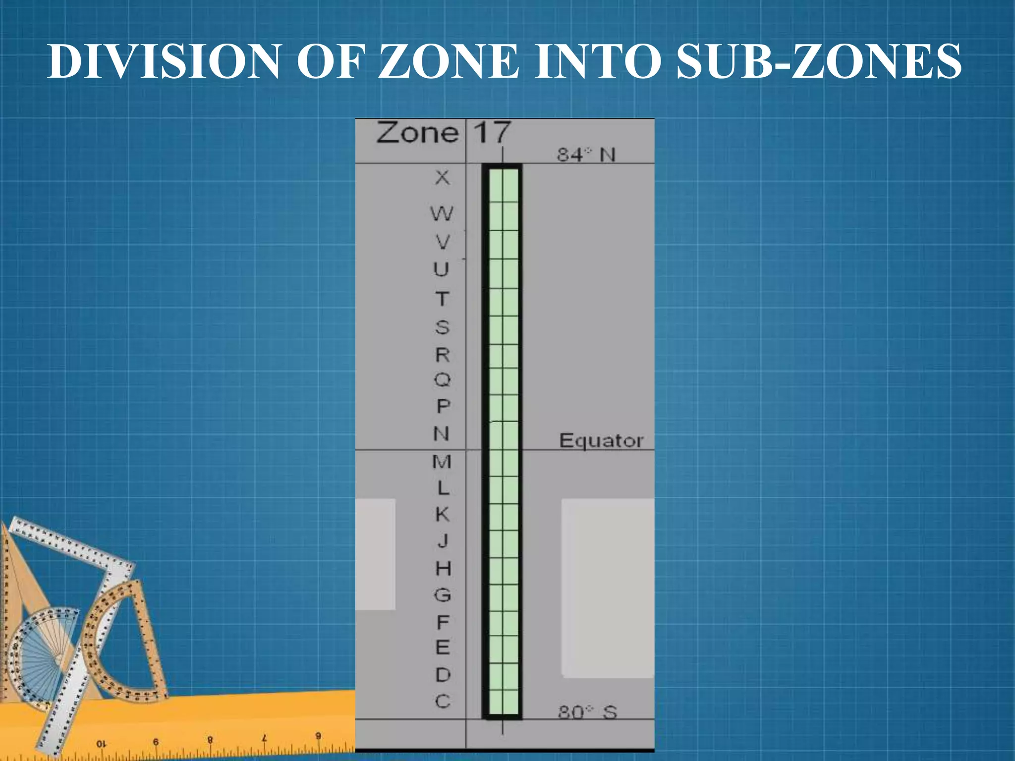
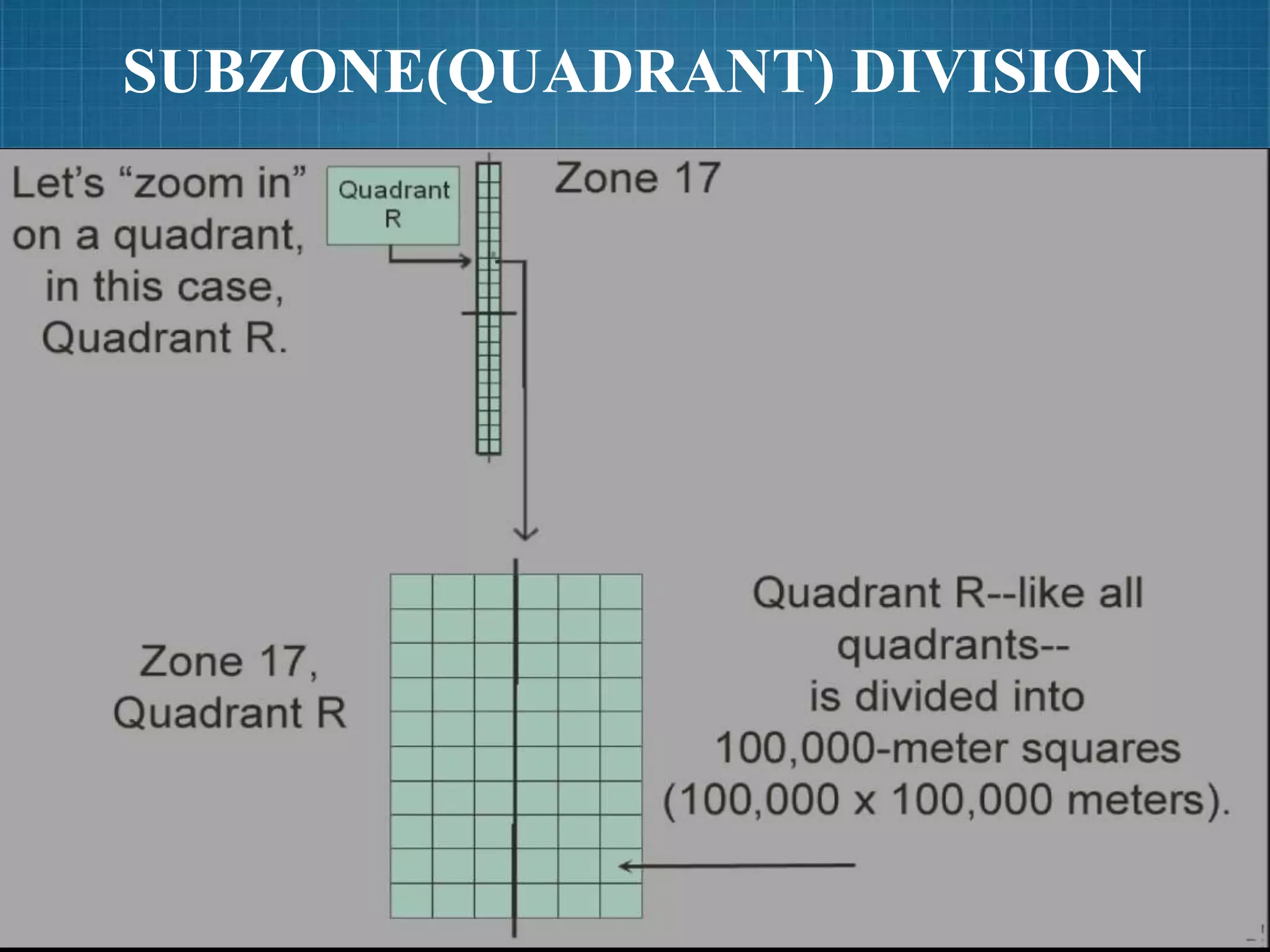
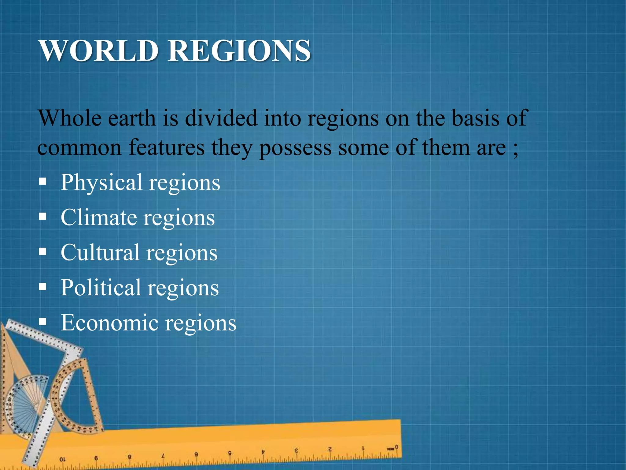
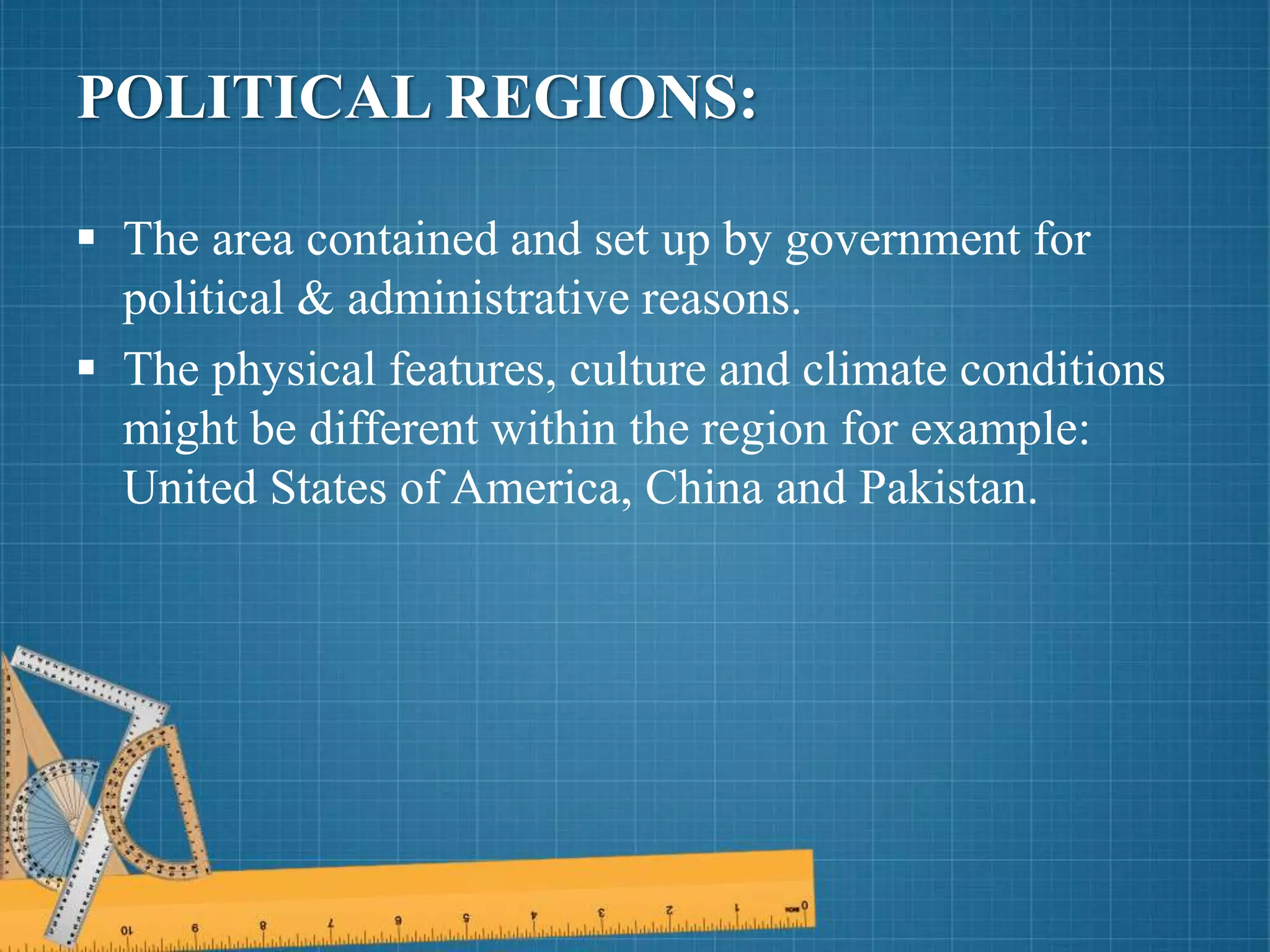
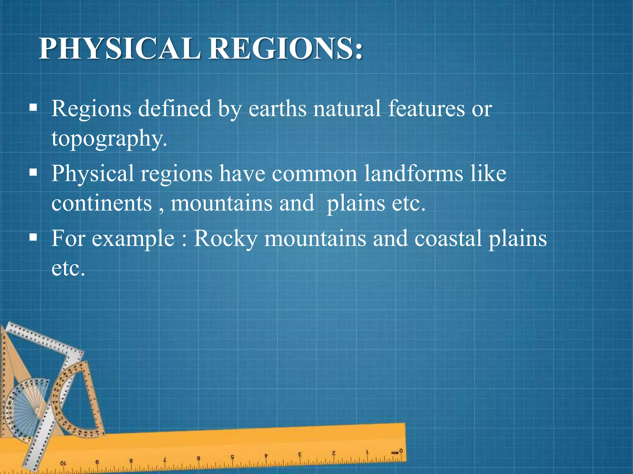
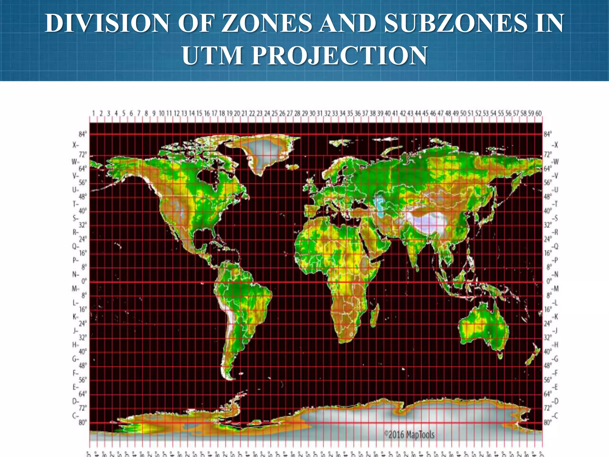
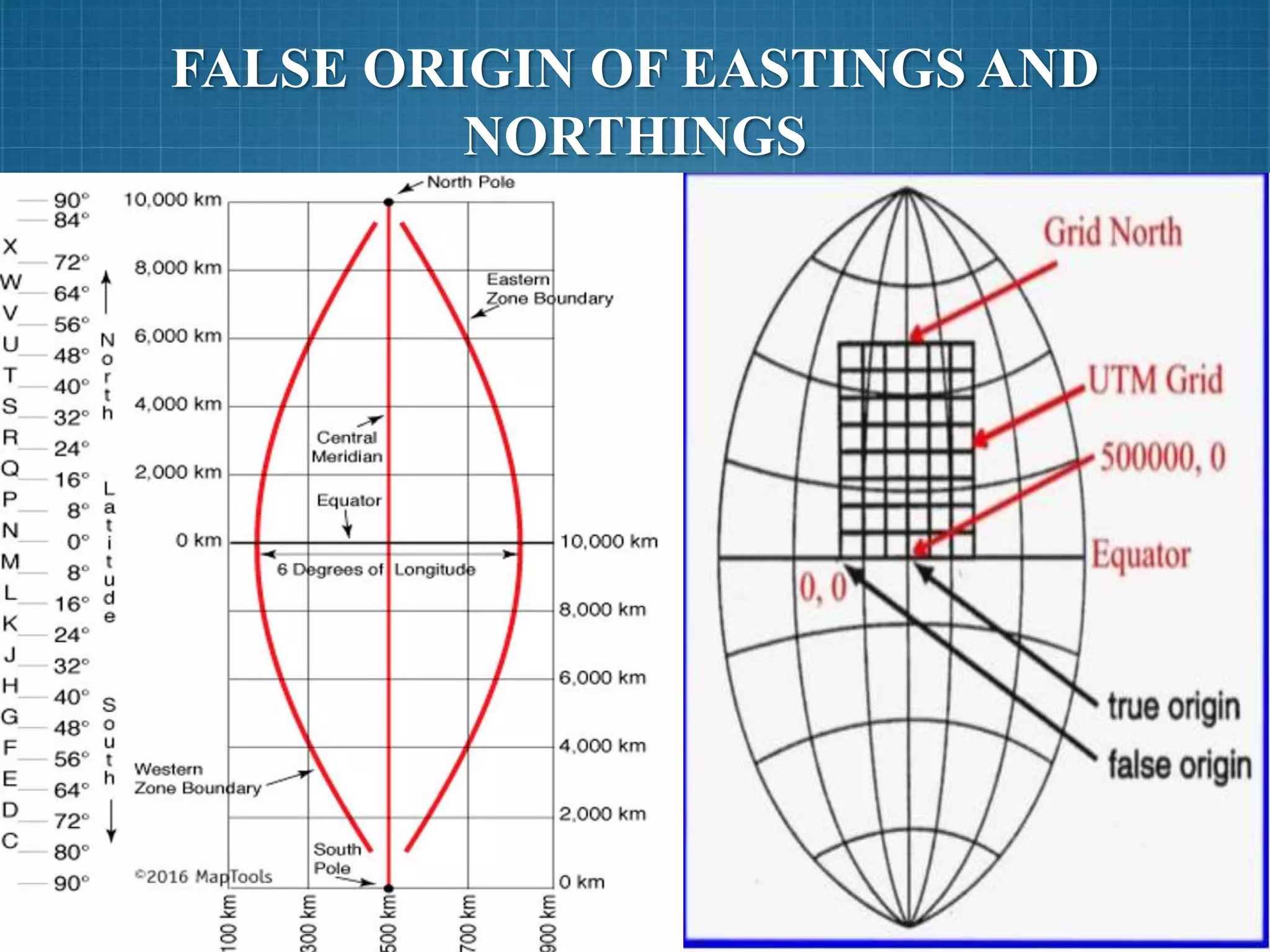
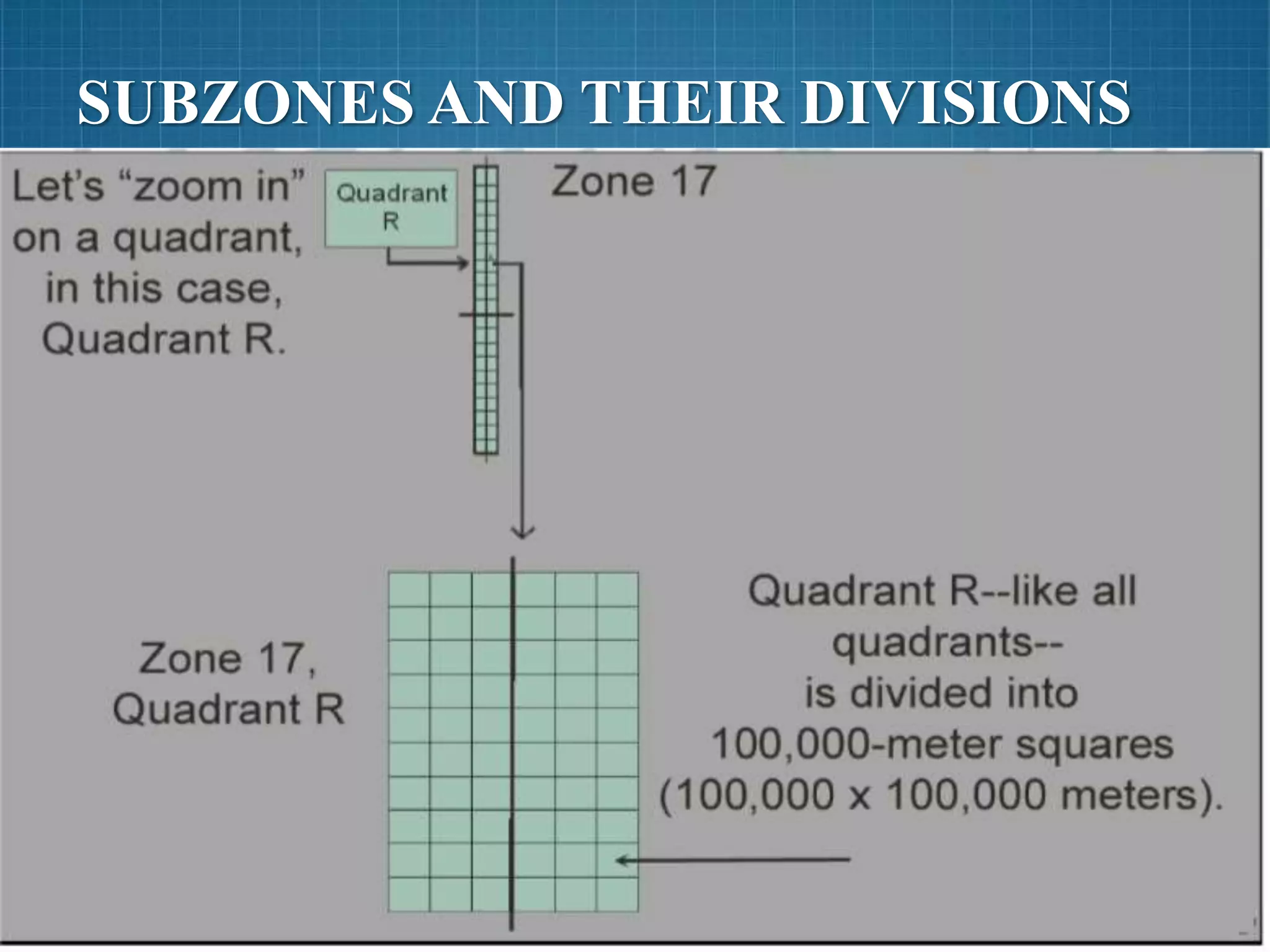
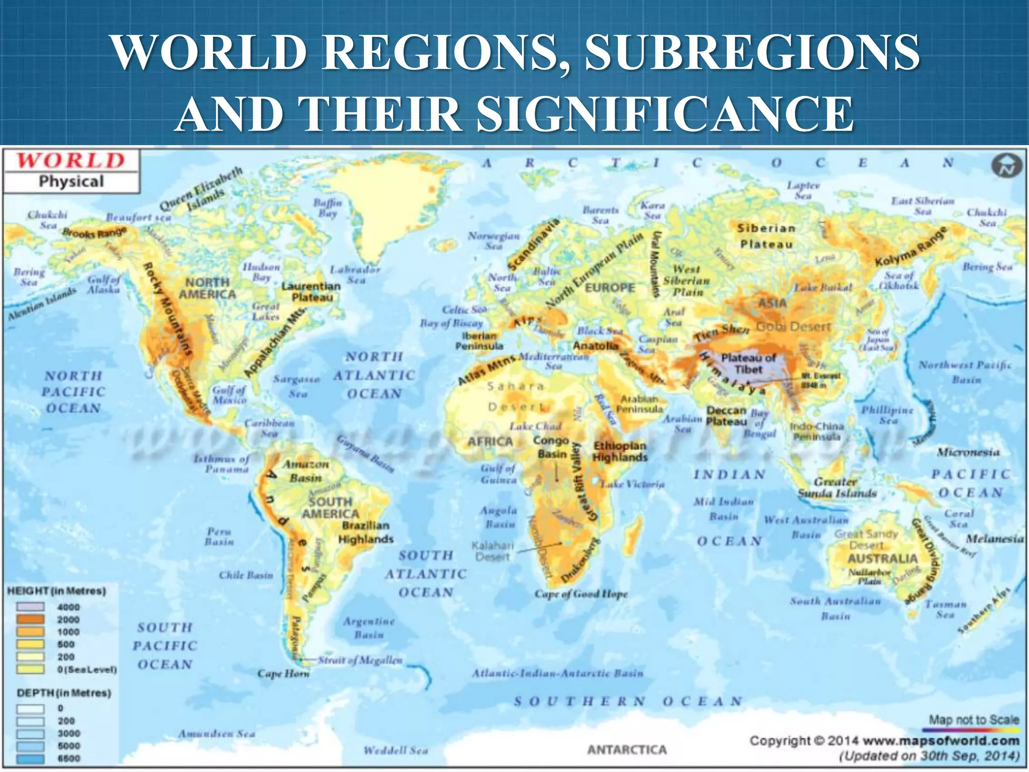
SlideShare a Scribd company logo
1 of 61
UNIVERSAL TRANSVERSE MERCATOR
PREPARED BY MUHAMMAD AAMIR
MANZOOR
NATIONAL UNIVERSITY OF SCINCES AND
TECHNOLOGY, ISLAMABAD
GROUP MEMBERS
 MUHAMMAD AAMIR
MANZOOR
 HASEEB ULLAH KHAN
 HAFIZ TAIMOOR EJAZ
 SHAIRYAR SHOUKAT
 SHAKIR KHURSHID
 SYED SADAF ABBAS
KAZMI
 ZIA ULLAH
 SUHAIL AHMED
 ARSALAN MALIK
 IBRAHIM KAMAL
CONTENTS
 OVERVIEW OF ZONES AND SUBZONES
 FALSE VALUES OF ORIGIN
 IDENTIFICATION OF 100*100KM SQ.
 REGION AND SUB-REGIONS IDENTIFICATION
 SUMMARY
DETAILED DESIGN OF EACH ZONE
AND OVERVIEW OF DIFFERENT
ASPECTS WITH DIAGRAM
 60 zones
 Numbered from 1-60
 6 degrees of longitude wide.
 80° S to 84° N
 In the Polar Regions
Universal Polar Stereographic (UPS) is used
 Note that there are a few exceptions to zone width in
Northern Europe to keep small countries in a single
zone.
UTM ZONES
 Zone 1 extends from 180° W to 174° W and is
centered on 177° W.
 Zone 2 extends from 174° W to 168° W and is
centered on 171° W.
 Zone 3 extends from 168° W to 162° W and is
centered on 165° W.
 Zone 4 extends from 162° W to 156° W and is
centered on 159° W. And so on…
UTM ZONES
Zone
Central
Meridian
Longitude Zone
Central
Meridian
Longitude
1 177W 180W-174W 31 3E 0-6E
2 171W 174W-168W 32 9E 6E-12E
3 165W 168W-162W 33 15E 12E-18E
4 159W 162W-156W 34 21E 18E-24E
5 153W 156W-150W 35 27E 24E-30E
6 147W 150W-144W 36 33E 30E-36E
7 141W 144W-138W 37 39E 36E-42E
8 135W 138W-132W 38 45E 42E-48E
9 129W 132W-126W 39 51E 48E-54E
10 123W 126W-120W 40 57E 54E-60E
11 117W 120W-114W 41 63E 60E-66E
12 111W 114W-108W 42 69E 66E-72E
13 105W 108W-102W 43 75E 72E-78E
14 99W 102W-96W 44 81E 78E-84E
15 93W 96W-90W 45 87E 84E-90E
16 87W 90W-84W 46 93E 90E-96E
17 81W 84W-78W 47 99E 96E-102E
18 75W 78W-72W 48 105E 102E-108E
19 69W 72W-66W 49 111E 108E-114E
20 63W 66W-60W 50 117E 114E-120E
21 57W 60W-54W 51 123E 120E-126E
22 51W 54W-48W 52 129E 126E-132E
23 45W 48W-42W 53 135E 132E-138E
24 39W 42W-36W 54 141E 138E-144E
25 33W 36W-30W 55 147E 144E-150E
26 27W 30W-24W 56 153E 150E-156E
27 21W 24W-18W 57 159E 156E-162E
28 15W 18W-12W 58 165E 162E-168E
29 9W 12W-6W 59 171E 168E-174E
30 3W 6W-0 60 177E 174E-180E
 20 subzones
 Littered Alphabetically
 Each zone is divided into horizontal bands spanning 8
degrees of latitude. These bands are lettered, south to
north, beginning at 80° S with the letter C and ending
with the letter X at 84° N. The letters I and O are
skipped to avoid confusion with the numbers one and
zero. The band lettered X spans 12° of latitude.
UTM SUBZONES
EASTINGS ANDA NORTHINGS
WITHIN A ZONE
 A single grid zone measures about 20,000km tall and
only about 700km wide. So the above diagram has been
compressed in the vertical axis by about 15X. The
eastern and western zone boundaries are truly much
straighter
 A square grid is superimposed on each zone. It's aligned
so that vertical grid lines are parallel to the center of the
zone, called the central meridian.
 UTM grid coordinates are expressed as a distance in
meters to the east, referred to as the "easting", and a
distance in meters to the north, referred to as the
"northing".
 UTM easting coordinates are referenced to the center line
of the zone known as the central meridian. The central
meridian is assigned an easting value of 500,000 meters
East. Since this 500,000m value is arbitrarily assigned,
eastings are sometimes referred to as "false eastings"
 An easting of zero will never occur, since a 6° wide zone
is never more than 674,000 meters wide.
 Minimum and maximum easting values are:
 160,000 mE and 834,000 mE at the equator
 465,000 mE and 515,000 mE at 84° N
EASTING
 UTM northing coordinates are measured relative to the equator. For
locations north of the equator the equator is assigned the northing value of
0 meters North. To avoid negative numbers, locations south of the equator
are made with the equator assigned a value of 10,000,000 meters North.
 Some UTM northing values are valid both north and south of the equator.
In order to avoid confusion the full coordinate needs to specify if the
location is north or south of the equator. Usually this is done by including
the letter for the latitude band.
 If this is your first exposure to the UTM coordinate system you may find
the layout of zones to be confusing. In most land navigation situations the
area of interest is much smaller than a zone. The notion of a zone falls
away and we are left with a simple rectangular coordinate system to use
with our large scale maps.

NORTHING
FALSE VALUES OF ORIGIN OF
GRID SYSTEM &
NUMBERING OF GRID LINES
GRID SYSTEM
GRID SYSTEM
 The north-south lines in a grid system are called
Eastings and increase in value from west to east.
 The east-west lines in a grid system are called
Northings and their value increases from south to
north.
 The numerical value of an Easting and Northing are
referenced to a specific origin.
GRID SYSTEM OF A ZONE OF UTM
WHY DO WE NEED A FALSE ORIGIN?
• Designation of the central meridian as the reference
y-axis (i.e. Easting = 0) of the coordinate system
within each zone would result in negative Easting
values For this reason, the central meridian is
assigned an arbitrary value of 500000 meters called
False Easting
• The equator is designated as the horizontal reference
axis for UTM Northing coordinates and is assigned a
value of 0 meters North (0m N) ,the equator is
assigned a value of 10,000,000 meters for referencing
Northing This is called False Northing
EXAMPLES
Examples
FALSE ORIGIN AND FALSE COORDINATES
False Origin and False coordinates
DIVISION OF ZONE INTO SUB-ZONES
SUBZONE(QUADRANT) DIVISION
NOMENCLATURE
IDENTIFICATION OF 100,000
SQUARE METER
WHAT IS 100*100 KM SQ.
 INTRODUCTION
 MGRS
Used by U.SA. Military & NATO
DIVISION OF SUBZONE
 Divided into 6*10
 Each 100 km * 100 km
 Further division
Each 100 km * 100 km square is
further divided into 10*10 boxes
 Each square has an area of 10 km * 10 km
WHY WE DIVIDE A SUBZONE
 Area vary form 1,000,000 to 15,000,000
 not sufficient to tell a specific point
 To determine exact position, a subzone is
divided into squares and these squares are
further divided.
NAMING OF SQUARES
 Square resulting from intersection of columns
and rows.
 Column and row names alphabetically
 Column & Rows are lettered from A to Z
(omitting I & O)
 Starts from equator (up & down)
 First column then row gets the name
 Columns can be stagger but rows do not stagger
 EXAMPLE
 3PTR means the point is located in
subzone 3P within the square tr
NAMING OF SQUARES
REGIONS AND SUB-REGIONS
REGION
 Definition:
A region is defined as an area with common features
that set it apart from other areas. Regions can vary in size from
very small to half of the earth's surface.
WORLD REGIONS
Whole earth is divided into regions on the basis of
common features they possess some of them are ;
 Physical regions
 Climate regions
 Cultural regions
 Political regions
 Economic regions
POLITICAL REGIONS:
 The area contained and set up by government for
political & administrative reasons.
 The physical features, culture and climate conditions
might be different within the region for example:
United States of America, China and Pakistan.
PHYSICAL REGIONS:
 Regions defined by earths natural features or
topography.
 Physical regions have common landforms like
continents , mountains and plains etc.
 For example : Rocky mountains and coastal plains
etc.
CLIMATE REGIONS :
 Based on weather pattern of an area over long period
of time common features are rainfall totals ,
temperature averages for example :
 Climate at the equator is hot and humid and climate at
north pole is cold and snowy.
CULTURAL REGIONS:
 The language, religion and ethnic heritage of a group of
people. Common features are groups with common
languages, religions and nationalities.
 For example: Latin America is a cultural region, it
includes South America, Central America and the
Caribbean islands. Most people speak Spanish, Portuguese
or French, most people are Roman Catholic In faith so it
puts together wide range of people together with similar
characteristics.
POLITICAL REGIONS:
 The area contained and set up by
government for political & administrative
reasons.
 The physical features, culture and climate
conditions might be different within the
region for example: United States of
America, China and Pakistan.
ECONOMIC REGION :
 An economic region is an area in which particular
types of commerce take place based on administrative
or geographical boundaries. These boundaries come
in the form of state lines, international borders or
natural geographic landmarks.
SUB REGION :
 A sub region is a part of a larger region or continent
and is usually based on location.
 Cardinal directions, such as south or southern, are
commonly used to define a sub region.
 For example
Asia is a region further divided into sub regions
like Central Asia, Eastern Asia, Southeastern
Asia, Southern Asia, Western Asia.
 Like divisions of Regions, sub-regions also follows
the same pattern for sub-divisions i.e.
Administrative, cultural and geographical etc.
SUB-REGION
CONCLUSIONS
DIVISION OF ZONES AND SUBZONES IN
UTM PROJECTION
•
EASTING & NORTHINGS
FALSE ORIGIN OF EASTINGS AND
NORTHINGS
SUBZONES AND THEIR DIVISIONS
•
NOMENCLATURE IN SUBZONES
•
MILITARY GRID REFERENCE SYSTEM
(MGRS) AND HOW REGIONS ARE
LOCATED (WHOLE TO POINT.)
WORLD REGIONS, SUBREGIONS
AND THEIR SIGNIFICANCE
UTM UNIVERSAL TRANSVERSE MERCATOR

More Related Content

What's hot

Geometry of Aerial photograph
Geometry of Aerial photographGeometry of Aerial photograph
Geometry of Aerial photographApoorva Mathur
 
Remote Sensing Platforms and Its types
Remote Sensing Platforms and Its typesRemote Sensing Platforms and Its types
Remote Sensing Platforms and Its typesSenthamizhan M
 
Geo referencing by Mashhood Arif
Geo referencing by Mashhood ArifGeo referencing by Mashhood Arif
Geo referencing by Mashhood ArifKU Leuven
 
Introduction to Landsat
Introduction to LandsatIntroduction to Landsat
Introduction to LandsatNizam GIS
 
Introduction to GPS
Introduction to GPSIntroduction to GPS
Introduction to GPSDaniel Kim
 
Introduction to MAPS,Coordinate System and Projection System
Introduction to MAPS,Coordinate System and Projection SystemIntroduction to MAPS,Coordinate System and Projection System
Introduction to MAPS,Coordinate System and Projection SystemNAXA-Developers
 
CARTOGRAPHY – yesterday, today and tomorrow
CARTOGRAPHY – yesterday, today and tomorrowCARTOGRAPHY – yesterday, today and tomorrow
CARTOGRAPHY – yesterday, today and tomorrowProf Ashis Sarkar
 
Chapter 1 (Introduction to remote sensing)
Chapter 1 (Introduction to remote sensing)Chapter 1 (Introduction to remote sensing)
Chapter 1 (Introduction to remote sensing)Shankar Gangaju
 
Intro to GIS and Remote Sensing
Intro to GIS and Remote SensingIntro to GIS and Remote Sensing
Intro to GIS and Remote SensingJohn Reiser
 
Aerial photography abraham thomas
Aerial photography abraham thomasAerial photography abraham thomas
Aerial photography abraham thomasSumant Diwakar
 

What's hot (20)

Optical remote sensing
Optical remote sensingOptical remote sensing
Optical remote sensing
 
Geometry of Aerial photograph
Geometry of Aerial photographGeometry of Aerial photograph
Geometry of Aerial photograph
 
datum
datumdatum
datum
 
Gis georeference
Gis georeferenceGis georeference
Gis georeference
 
Remote Sensing Platforms and Its types
Remote Sensing Platforms and Its typesRemote Sensing Platforms and Its types
Remote Sensing Platforms and Its types
 
Geo referencing by Mashhood Arif
Geo referencing by Mashhood ArifGeo referencing by Mashhood Arif
Geo referencing by Mashhood Arif
 
Introduction to Aerial Photogrammetry
Introduction to Aerial PhotogrammetryIntroduction to Aerial Photogrammetry
Introduction to Aerial Photogrammetry
 
Introduction to Landsat
Introduction to LandsatIntroduction to Landsat
Introduction to Landsat
 
Map projections
Map projectionsMap projections
Map projections
 
Remote sensing
Remote sensingRemote sensing
Remote sensing
 
Introduction to GPS
Introduction to GPSIntroduction to GPS
Introduction to GPS
 
Introduction to MAPS,Coordinate System and Projection System
Introduction to MAPS,Coordinate System and Projection SystemIntroduction to MAPS,Coordinate System and Projection System
Introduction to MAPS,Coordinate System and Projection System
 
Map projection
Map projectionMap projection
Map projection
 
CARTOGRAPHY – yesterday, today and tomorrow
CARTOGRAPHY – yesterday, today and tomorrowCARTOGRAPHY – yesterday, today and tomorrow
CARTOGRAPHY – yesterday, today and tomorrow
 
Map projections
Map projectionsMap projections
Map projections
 
Chapter 1 (Introduction to remote sensing)
Chapter 1 (Introduction to remote sensing)Chapter 1 (Introduction to remote sensing)
Chapter 1 (Introduction to remote sensing)
 
Types of Ellipsoid
Types of EllipsoidTypes of Ellipsoid
Types of Ellipsoid
 
Intro to GIS and Remote Sensing
Intro to GIS and Remote SensingIntro to GIS and Remote Sensing
Intro to GIS and Remote Sensing
 
Cartography
CartographyCartography
Cartography
 
Aerial photography abraham thomas
Aerial photography abraham thomasAerial photography abraham thomas
Aerial photography abraham thomas
 

Viewers also liked

What is grid system
What is grid systemWhat is grid system
What is grid systemchetankane
 
Geographic query and analysis
Geographic query and analysisGeographic query and analysis
Geographic query and analysisMohsin Siddique
 
Coordinate systems
Coordinate systemsCoordinate systems
Coordinate systemsSaad Raja
 
Coordinate systems (Lecture 3)
Coordinate systems (Lecture 3)Coordinate systems (Lecture 3)
Coordinate systems (Lecture 3)Olexiy Pogurelskiy
 
Industrial Disaster Management
Industrial Disaster ManagementIndustrial Disaster Management
Industrial Disaster ManagementPsunita Rao
 

Viewers also liked (7)

Map grids
Map gridsMap grids
Map grids
 
Types Of Grid Maps
Types Of Grid MapsTypes Of Grid Maps
Types Of Grid Maps
 
What is grid system
What is grid systemWhat is grid system
What is grid system
 
Geographic query and analysis
Geographic query and analysisGeographic query and analysis
Geographic query and analysis
 
Coordinate systems
Coordinate systemsCoordinate systems
Coordinate systems
 
Coordinate systems (Lecture 3)
Coordinate systems (Lecture 3)Coordinate systems (Lecture 3)
Coordinate systems (Lecture 3)
 
Industrial Disaster Management
Industrial Disaster ManagementIndustrial Disaster Management
Industrial Disaster Management
 

Similar to UTM UNIVERSAL TRANSVERSE MERCATOR

THE GLOBE AND ITS FEATURES
THE GLOBE AND ITS FEATURESTHE GLOBE AND ITS FEATURES
THE GLOBE AND ITS FEATURESRosalina Dumayac
 
Aerial NAVIGATION and FLIGHT PLANNING.pptx
Aerial NAVIGATION and FLIGHT PLANNING.pptxAerial NAVIGATION and FLIGHT PLANNING.pptx
Aerial NAVIGATION and FLIGHT PLANNING.pptxEhtasham Amir
 
Latitude and longitude
Latitude and longitudeLatitude and longitude
Latitude and longitudedwinter1
 
Latitude and Longitude
Latitude and LongitudeLatitude and Longitude
Latitude and Longitudedwinter1
 
araling panlipunan second quarter
araling panlipunan second quarteraraling panlipunan second quarter
araling panlipunan second quarterSvenn Lathrop
 
_L-14 The Globe- Latitudes and Longitudes new.pptx
_L-14 The Globe- Latitudes and Longitudes new.pptx_L-14 The Globe- Latitudes and Longitudes new.pptx
_L-14 The Globe- Latitudes and Longitudes new.pptxpadminijyothi
 
Geography five lab one
Geography five lab oneGeography five lab one
Geography five lab onelschmidt1170
 
Lab two location and time
Lab two location and timeLab two location and time
Lab two location and timelschmidt1170
 
Lines of Latitude and Longitude – PowerPoint
Lines of Latitude and Longitude – PowerPointLines of Latitude and Longitude – PowerPoint
Lines of Latitude and Longitude – PowerPointYaryalitsa
 
Cordinate system and map projection.pdf
Cordinate system and map projection.pdfCordinate system and map projection.pdf
Cordinate system and map projection.pdfsamuelzewdu3
 
Geography five lab one
Geography five lab oneGeography five lab one
Geography five lab onelschmidt1170
 
The Globe And It's Features
The Globe And It's FeaturesThe Globe And It's Features
The Globe And It's FeaturesRonel Ragmat
 
Longitude and latitude gr 10.pptx
Longitude and latitude gr 10.pptxLongitude and latitude gr 10.pptx
Longitude and latitude gr 10.pptxlyba643
 
Longitude and latitude
Longitude and latitudeLongitude and latitude
Longitude and latitudeHolley Stabler
 
longitude-latitude-and-equator-1.pptx
longitude-latitude-and-equator-1.pptxlongitude-latitude-and-equator-1.pptx
longitude-latitude-and-equator-1.pptxMaryJoySalgado3
 

Similar to UTM UNIVERSAL TRANSVERSE MERCATOR (20)

WEEK1-Q4.pptx
WEEK1-Q4.pptxWEEK1-Q4.pptx
WEEK1-Q4.pptx
 
THE GLOBE AND ITS FEATURES
THE GLOBE AND ITS FEATURESTHE GLOBE AND ITS FEATURES
THE GLOBE AND ITS FEATURES
 
projections.docx
projections.docxprojections.docx
projections.docx
 
Aerial NAVIGATION and FLIGHT PLANNING.pptx
Aerial NAVIGATION and FLIGHT PLANNING.pptxAerial NAVIGATION and FLIGHT PLANNING.pptx
Aerial NAVIGATION and FLIGHT PLANNING.pptx
 
Latitude and longitude
Latitude and longitudeLatitude and longitude
Latitude and longitude
 
Latitude and Longitude
Latitude and LongitudeLatitude and Longitude
Latitude and Longitude
 
araling panlipunan second quarter
araling panlipunan second quarteraraling panlipunan second quarter
araling panlipunan second quarter
 
_L-14 The Globe- Latitudes and Longitudes new.pptx
_L-14 The Globe- Latitudes and Longitudes new.pptx_L-14 The Globe- Latitudes and Longitudes new.pptx
_L-14 The Globe- Latitudes and Longitudes new.pptx
 
Earths dimension sci 8 ppt np1
Earths dimension sci 8 ppt np1Earths dimension sci 8 ppt np1
Earths dimension sci 8 ppt np1
 
Geography five lab one
Geography five lab oneGeography five lab one
Geography five lab one
 
Mapping the earth
Mapping the earthMapping the earth
Mapping the earth
 
Lab two location and time
Lab two location and timeLab two location and time
Lab two location and time
 
Location and time
Location and timeLocation and time
Location and time
 
Lines of Latitude and Longitude – PowerPoint
Lines of Latitude and Longitude – PowerPointLines of Latitude and Longitude – PowerPoint
Lines of Latitude and Longitude – PowerPoint
 
Cordinate system and map projection.pdf
Cordinate system and map projection.pdfCordinate system and map projection.pdf
Cordinate system and map projection.pdf
 
Geography five lab one
Geography five lab oneGeography five lab one
Geography five lab one
 
The Globe And It's Features
The Globe And It's FeaturesThe Globe And It's Features
The Globe And It's Features
 
Longitude and latitude gr 10.pptx
Longitude and latitude gr 10.pptxLongitude and latitude gr 10.pptx
Longitude and latitude gr 10.pptx
 
Longitude and latitude
Longitude and latitudeLongitude and latitude
Longitude and latitude
 
longitude-latitude-and-equator-1.pptx
longitude-latitude-and-equator-1.pptxlongitude-latitude-and-equator-1.pptx
longitude-latitude-and-equator-1.pptx
 

Recently uploaded

247267395-1-Symmetric-and-distributed-shared-memory-architectures-ppt (1).ppt
247267395-1-Symmetric-and-distributed-shared-memory-architectures-ppt (1).ppt247267395-1-Symmetric-and-distributed-shared-memory-architectures-ppt (1).ppt
247267395-1-Symmetric-and-distributed-shared-memory-architectures-ppt (1).pptssuser5c9d4b1
 
Call Girls Service Nagpur Tanvi Call 7001035870 Meet With Nagpur Escorts
Call Girls Service Nagpur Tanvi Call 7001035870 Meet With Nagpur EscortsCall Girls Service Nagpur Tanvi Call 7001035870 Meet With Nagpur Escorts
Call Girls Service Nagpur Tanvi Call 7001035870 Meet With Nagpur EscortsCall Girls in Nagpur High Profile
 
Structural Analysis and Design of Foundations: A Comprehensive Handbook for S...
Structural Analysis and Design of Foundations: A Comprehensive Handbook for S...Structural Analysis and Design of Foundations: A Comprehensive Handbook for S...
Structural Analysis and Design of Foundations: A Comprehensive Handbook for S...Dr.Costas Sachpazis
 
SPICE PARK APR2024 ( 6,793 SPICE Models )
SPICE PARK APR2024 ( 6,793 SPICE Models )SPICE PARK APR2024 ( 6,793 SPICE Models )
SPICE PARK APR2024 ( 6,793 SPICE Models )Tsuyoshi Horigome
 
Processing & Properties of Floor and Wall Tiles.pptx
Processing & Properties of Floor and Wall Tiles.pptxProcessing & Properties of Floor and Wall Tiles.pptx
Processing & Properties of Floor and Wall Tiles.pptxpranjaldaimarysona
 
(PRIYA) Rajgurunagar Call Girls Just Call 7001035870 [ Cash on Delivery ] Pun...
(PRIYA) Rajgurunagar Call Girls Just Call 7001035870 [ Cash on Delivery ] Pun...(PRIYA) Rajgurunagar Call Girls Just Call 7001035870 [ Cash on Delivery ] Pun...
(PRIYA) Rajgurunagar Call Girls Just Call 7001035870 [ Cash on Delivery ] Pun...ranjana rawat
 
College Call Girls Nashik Nehal 7001305949 Independent Escort Service Nashik
College Call Girls Nashik Nehal 7001305949 Independent Escort Service NashikCollege Call Girls Nashik Nehal 7001305949 Independent Escort Service Nashik
College Call Girls Nashik Nehal 7001305949 Independent Escort Service NashikCall Girls in Nagpur High Profile
 
Sheet Pile Wall Design and Construction: A Practical Guide for Civil Engineer...
Sheet Pile Wall Design and Construction: A Practical Guide for Civil Engineer...Sheet Pile Wall Design and Construction: A Practical Guide for Civil Engineer...
Sheet Pile Wall Design and Construction: A Practical Guide for Civil Engineer...Dr.Costas Sachpazis
 
the ladakh protest in leh ladakh 2024 sonam wangchuk.pptx
the ladakh protest in leh ladakh 2024 sonam wangchuk.pptxthe ladakh protest in leh ladakh 2024 sonam wangchuk.pptx
the ladakh protest in leh ladakh 2024 sonam wangchuk.pptxhumanexperienceaaa
 
Introduction and different types of Ethernet.pptx
Introduction and different types of Ethernet.pptxIntroduction and different types of Ethernet.pptx
Introduction and different types of Ethernet.pptxupamatechverse
 
VIP Call Girls Service Kondapur Hyderabad Call +91-8250192130
VIP Call Girls Service Kondapur Hyderabad Call +91-8250192130VIP Call Girls Service Kondapur Hyderabad Call +91-8250192130
VIP Call Girls Service Kondapur Hyderabad Call +91-8250192130Suhani Kapoor
 
MANUFACTURING PROCESS-II UNIT-2 LATHE MACHINE
MANUFACTURING PROCESS-II UNIT-2 LATHE MACHINEMANUFACTURING PROCESS-II UNIT-2 LATHE MACHINE
MANUFACTURING PROCESS-II UNIT-2 LATHE MACHINESIVASHANKAR N
 
(SHREYA) Chakan Call Girls Just Call 7001035870 [ Cash on Delivery ] Pune Esc...
(SHREYA) Chakan Call Girls Just Call 7001035870 [ Cash on Delivery ] Pune Esc...(SHREYA) Chakan Call Girls Just Call 7001035870 [ Cash on Delivery ] Pune Esc...
(SHREYA) Chakan Call Girls Just Call 7001035870 [ Cash on Delivery ] Pune Esc...ranjana rawat
 
Microscopic Analysis of Ceramic Materials.pptx
Microscopic Analysis of Ceramic Materials.pptxMicroscopic Analysis of Ceramic Materials.pptx
Microscopic Analysis of Ceramic Materials.pptxpurnimasatapathy1234
 
IMPLICATIONS OF THE ABOVE HOLISTIC UNDERSTANDING OF HARMONY ON PROFESSIONAL E...
IMPLICATIONS OF THE ABOVE HOLISTIC UNDERSTANDING OF HARMONY ON PROFESSIONAL E...IMPLICATIONS OF THE ABOVE HOLISTIC UNDERSTANDING OF HARMONY ON PROFESSIONAL E...
IMPLICATIONS OF THE ABOVE HOLISTIC UNDERSTANDING OF HARMONY ON PROFESSIONAL E...RajaP95
 
Software Development Life Cycle By Team Orange (Dept. of Pharmacy)
Software Development Life Cycle By  Team Orange (Dept. of Pharmacy)Software Development Life Cycle By  Team Orange (Dept. of Pharmacy)
Software Development Life Cycle By Team Orange (Dept. of Pharmacy)Suman Mia
 

Recently uploaded (20)

247267395-1-Symmetric-and-distributed-shared-memory-architectures-ppt (1).ppt
247267395-1-Symmetric-and-distributed-shared-memory-architectures-ppt (1).ppt247267395-1-Symmetric-and-distributed-shared-memory-architectures-ppt (1).ppt
247267395-1-Symmetric-and-distributed-shared-memory-architectures-ppt (1).ppt
 
Call Girls Service Nagpur Tanvi Call 7001035870 Meet With Nagpur Escorts
Call Girls Service Nagpur Tanvi Call 7001035870 Meet With Nagpur EscortsCall Girls Service Nagpur Tanvi Call 7001035870 Meet With Nagpur Escorts
Call Girls Service Nagpur Tanvi Call 7001035870 Meet With Nagpur Escorts
 
Structural Analysis and Design of Foundations: A Comprehensive Handbook for S...
Structural Analysis and Design of Foundations: A Comprehensive Handbook for S...Structural Analysis and Design of Foundations: A Comprehensive Handbook for S...
Structural Analysis and Design of Foundations: A Comprehensive Handbook for S...
 
DJARUM4D - SLOT GACOR ONLINE | SLOT DEMO ONLINE
DJARUM4D - SLOT GACOR ONLINE | SLOT DEMO ONLINEDJARUM4D - SLOT GACOR ONLINE | SLOT DEMO ONLINE
DJARUM4D - SLOT GACOR ONLINE | SLOT DEMO ONLINE
 
SPICE PARK APR2024 ( 6,793 SPICE Models )
SPICE PARK APR2024 ( 6,793 SPICE Models )SPICE PARK APR2024 ( 6,793 SPICE Models )
SPICE PARK APR2024 ( 6,793 SPICE Models )
 
Processing & Properties of Floor and Wall Tiles.pptx
Processing & Properties of Floor and Wall Tiles.pptxProcessing & Properties of Floor and Wall Tiles.pptx
Processing & Properties of Floor and Wall Tiles.pptx
 
Roadmap to Membership of RICS - Pathways and Routes
Roadmap to Membership of RICS - Pathways and RoutesRoadmap to Membership of RICS - Pathways and Routes
Roadmap to Membership of RICS - Pathways and Routes
 
(PRIYA) Rajgurunagar Call Girls Just Call 7001035870 [ Cash on Delivery ] Pun...
(PRIYA) Rajgurunagar Call Girls Just Call 7001035870 [ Cash on Delivery ] Pun...(PRIYA) Rajgurunagar Call Girls Just Call 7001035870 [ Cash on Delivery ] Pun...
(PRIYA) Rajgurunagar Call Girls Just Call 7001035870 [ Cash on Delivery ] Pun...
 
College Call Girls Nashik Nehal 7001305949 Independent Escort Service Nashik
College Call Girls Nashik Nehal 7001305949 Independent Escort Service NashikCollege Call Girls Nashik Nehal 7001305949 Independent Escort Service Nashik
College Call Girls Nashik Nehal 7001305949 Independent Escort Service Nashik
 
★ CALL US 9953330565 ( HOT Young Call Girls In Badarpur delhi NCR
★ CALL US 9953330565 ( HOT Young Call Girls In Badarpur delhi NCR★ CALL US 9953330565 ( HOT Young Call Girls In Badarpur delhi NCR
★ CALL US 9953330565 ( HOT Young Call Girls In Badarpur delhi NCR
 
Call Us -/9953056974- Call Girls In Vikaspuri-/- Delhi NCR
Call Us -/9953056974- Call Girls In Vikaspuri-/- Delhi NCRCall Us -/9953056974- Call Girls In Vikaspuri-/- Delhi NCR
Call Us -/9953056974- Call Girls In Vikaspuri-/- Delhi NCR
 
Sheet Pile Wall Design and Construction: A Practical Guide for Civil Engineer...
Sheet Pile Wall Design and Construction: A Practical Guide for Civil Engineer...Sheet Pile Wall Design and Construction: A Practical Guide for Civil Engineer...
Sheet Pile Wall Design and Construction: A Practical Guide for Civil Engineer...
 
the ladakh protest in leh ladakh 2024 sonam wangchuk.pptx
the ladakh protest in leh ladakh 2024 sonam wangchuk.pptxthe ladakh protest in leh ladakh 2024 sonam wangchuk.pptx
the ladakh protest in leh ladakh 2024 sonam wangchuk.pptx
 
Introduction and different types of Ethernet.pptx
Introduction and different types of Ethernet.pptxIntroduction and different types of Ethernet.pptx
Introduction and different types of Ethernet.pptx
 
VIP Call Girls Service Kondapur Hyderabad Call +91-8250192130
VIP Call Girls Service Kondapur Hyderabad Call +91-8250192130VIP Call Girls Service Kondapur Hyderabad Call +91-8250192130
VIP Call Girls Service Kondapur Hyderabad Call +91-8250192130
 
MANUFACTURING PROCESS-II UNIT-2 LATHE MACHINE
MANUFACTURING PROCESS-II UNIT-2 LATHE MACHINEMANUFACTURING PROCESS-II UNIT-2 LATHE MACHINE
MANUFACTURING PROCESS-II UNIT-2 LATHE MACHINE
 
(SHREYA) Chakan Call Girls Just Call 7001035870 [ Cash on Delivery ] Pune Esc...
(SHREYA) Chakan Call Girls Just Call 7001035870 [ Cash on Delivery ] Pune Esc...(SHREYA) Chakan Call Girls Just Call 7001035870 [ Cash on Delivery ] Pune Esc...
(SHREYA) Chakan Call Girls Just Call 7001035870 [ Cash on Delivery ] Pune Esc...
 
Microscopic Analysis of Ceramic Materials.pptx
Microscopic Analysis of Ceramic Materials.pptxMicroscopic Analysis of Ceramic Materials.pptx
Microscopic Analysis of Ceramic Materials.pptx
 
IMPLICATIONS OF THE ABOVE HOLISTIC UNDERSTANDING OF HARMONY ON PROFESSIONAL E...
IMPLICATIONS OF THE ABOVE HOLISTIC UNDERSTANDING OF HARMONY ON PROFESSIONAL E...IMPLICATIONS OF THE ABOVE HOLISTIC UNDERSTANDING OF HARMONY ON PROFESSIONAL E...
IMPLICATIONS OF THE ABOVE HOLISTIC UNDERSTANDING OF HARMONY ON PROFESSIONAL E...
 
Software Development Life Cycle By Team Orange (Dept. of Pharmacy)
Software Development Life Cycle By  Team Orange (Dept. of Pharmacy)Software Development Life Cycle By  Team Orange (Dept. of Pharmacy)
Software Development Life Cycle By Team Orange (Dept. of Pharmacy)
 

UTM UNIVERSAL TRANSVERSE MERCATOR

  • 1. UNIVERSAL TRANSVERSE MERCATOR PREPARED BY MUHAMMAD AAMIR MANZOOR NATIONAL UNIVERSITY OF SCINCES AND TECHNOLOGY, ISLAMABAD
  • 2. GROUP MEMBERS  MUHAMMAD AAMIR MANZOOR  HASEEB ULLAH KHAN  HAFIZ TAIMOOR EJAZ  SHAIRYAR SHOUKAT  SHAKIR KHURSHID  SYED SADAF ABBAS KAZMI  ZIA ULLAH  SUHAIL AHMED  ARSALAN MALIK  IBRAHIM KAMAL
  • 3. CONTENTS  OVERVIEW OF ZONES AND SUBZONES  FALSE VALUES OF ORIGIN  IDENTIFICATION OF 100*100KM SQ.  REGION AND SUB-REGIONS IDENTIFICATION  SUMMARY
  • 4.
  • 5. DETAILED DESIGN OF EACH ZONE AND OVERVIEW OF DIFFERENT ASPECTS WITH DIAGRAM
  • 6.  60 zones  Numbered from 1-60  6 degrees of longitude wide.  80° S to 84° N  In the Polar Regions Universal Polar Stereographic (UPS) is used  Note that there are a few exceptions to zone width in Northern Europe to keep small countries in a single zone. UTM ZONES
  • 7.  Zone 1 extends from 180° W to 174° W and is centered on 177° W.  Zone 2 extends from 174° W to 168° W and is centered on 171° W.  Zone 3 extends from 168° W to 162° W and is centered on 165° W.  Zone 4 extends from 162° W to 156° W and is centered on 159° W. And so on… UTM ZONES
  • 8. Zone Central Meridian Longitude Zone Central Meridian Longitude 1 177W 180W-174W 31 3E 0-6E 2 171W 174W-168W 32 9E 6E-12E 3 165W 168W-162W 33 15E 12E-18E 4 159W 162W-156W 34 21E 18E-24E 5 153W 156W-150W 35 27E 24E-30E 6 147W 150W-144W 36 33E 30E-36E 7 141W 144W-138W 37 39E 36E-42E 8 135W 138W-132W 38 45E 42E-48E 9 129W 132W-126W 39 51E 48E-54E 10 123W 126W-120W 40 57E 54E-60E 11 117W 120W-114W 41 63E 60E-66E 12 111W 114W-108W 42 69E 66E-72E 13 105W 108W-102W 43 75E 72E-78E 14 99W 102W-96W 44 81E 78E-84E
  • 9. 15 93W 96W-90W 45 87E 84E-90E 16 87W 90W-84W 46 93E 90E-96E 17 81W 84W-78W 47 99E 96E-102E 18 75W 78W-72W 48 105E 102E-108E 19 69W 72W-66W 49 111E 108E-114E 20 63W 66W-60W 50 117E 114E-120E 21 57W 60W-54W 51 123E 120E-126E 22 51W 54W-48W 52 129E 126E-132E 23 45W 48W-42W 53 135E 132E-138E 24 39W 42W-36W 54 141E 138E-144E 25 33W 36W-30W 55 147E 144E-150E 26 27W 30W-24W 56 153E 150E-156E 27 21W 24W-18W 57 159E 156E-162E 28 15W 18W-12W 58 165E 162E-168E 29 9W 12W-6W 59 171E 168E-174E 30 3W 6W-0 60 177E 174E-180E
  • 10.
  • 11.  20 subzones  Littered Alphabetically  Each zone is divided into horizontal bands spanning 8 degrees of latitude. These bands are lettered, south to north, beginning at 80° S with the letter C and ending with the letter X at 84° N. The letters I and O are skipped to avoid confusion with the numbers one and zero. The band lettered X spans 12° of latitude. UTM SUBZONES
  • 13.  A single grid zone measures about 20,000km tall and only about 700km wide. So the above diagram has been compressed in the vertical axis by about 15X. The eastern and western zone boundaries are truly much straighter  A square grid is superimposed on each zone. It's aligned so that vertical grid lines are parallel to the center of the zone, called the central meridian.  UTM grid coordinates are expressed as a distance in meters to the east, referred to as the "easting", and a distance in meters to the north, referred to as the "northing".
  • 14.  UTM easting coordinates are referenced to the center line of the zone known as the central meridian. The central meridian is assigned an easting value of 500,000 meters East. Since this 500,000m value is arbitrarily assigned, eastings are sometimes referred to as "false eastings"  An easting of zero will never occur, since a 6° wide zone is never more than 674,000 meters wide.  Minimum and maximum easting values are:  160,000 mE and 834,000 mE at the equator  465,000 mE and 515,000 mE at 84° N EASTING
  • 15.  UTM northing coordinates are measured relative to the equator. For locations north of the equator the equator is assigned the northing value of 0 meters North. To avoid negative numbers, locations south of the equator are made with the equator assigned a value of 10,000,000 meters North.  Some UTM northing values are valid both north and south of the equator. In order to avoid confusion the full coordinate needs to specify if the location is north or south of the equator. Usually this is done by including the letter for the latitude band.  If this is your first exposure to the UTM coordinate system you may find the layout of zones to be confusing. In most land navigation situations the area of interest is much smaller than a zone. The notion of a zone falls away and we are left with a simple rectangular coordinate system to use with our large scale maps.  NORTHING
  • 16. FALSE VALUES OF ORIGIN OF GRID SYSTEM & NUMBERING OF GRID LINES
  • 17.
  • 19. GRID SYSTEM  The north-south lines in a grid system are called Eastings and increase in value from west to east.  The east-west lines in a grid system are called Northings and their value increases from south to north.  The numerical value of an Easting and Northing are referenced to a specific origin.
  • 20. GRID SYSTEM OF A ZONE OF UTM
  • 21. WHY DO WE NEED A FALSE ORIGIN?
  • 22. WHY DO WE NEED A FALSE ORIGIN? • Designation of the central meridian as the reference y-axis (i.e. Easting = 0) of the coordinate system within each zone would result in negative Easting values For this reason, the central meridian is assigned an arbitrary value of 500000 meters called False Easting • The equator is designated as the horizontal reference axis for UTM Northing coordinates and is assigned a value of 0 meters North (0m N) ,the equator is assigned a value of 10,000,000 meters for referencing Northing This is called False Northing
  • 25. FALSE ORIGIN AND FALSE COORDINATES
  • 26. False Origin and False coordinates
  • 27. DIVISION OF ZONE INTO SUB-ZONES
  • 31. WHAT IS 100*100 KM SQ.  INTRODUCTION  MGRS Used by U.SA. Military & NATO
  • 32. DIVISION OF SUBZONE  Divided into 6*10  Each 100 km * 100 km  Further division Each 100 km * 100 km square is further divided into 10*10 boxes  Each square has an area of 10 km * 10 km
  • 33. WHY WE DIVIDE A SUBZONE  Area vary form 1,000,000 to 15,000,000  not sufficient to tell a specific point  To determine exact position, a subzone is divided into squares and these squares are further divided.
  • 34. NAMING OF SQUARES  Square resulting from intersection of columns and rows.  Column and row names alphabetically  Column & Rows are lettered from A to Z (omitting I & O)  Starts from equator (up & down)  First column then row gets the name  Columns can be stagger but rows do not stagger
  • 35.  EXAMPLE  3PTR means the point is located in subzone 3P within the square tr NAMING OF SQUARES
  • 37. REGION  Definition: A region is defined as an area with common features that set it apart from other areas. Regions can vary in size from very small to half of the earth's surface.
  • 38. WORLD REGIONS Whole earth is divided into regions on the basis of common features they possess some of them are ;  Physical regions  Climate regions  Cultural regions  Political regions  Economic regions
  • 39. POLITICAL REGIONS:  The area contained and set up by government for political & administrative reasons.  The physical features, culture and climate conditions might be different within the region for example: United States of America, China and Pakistan.
  • 40. PHYSICAL REGIONS:  Regions defined by earths natural features or topography.  Physical regions have common landforms like continents , mountains and plains etc.  For example : Rocky mountains and coastal plains etc.
  • 41.
  • 42. CLIMATE REGIONS :  Based on weather pattern of an area over long period of time common features are rainfall totals , temperature averages for example :  Climate at the equator is hot and humid and climate at north pole is cold and snowy.
  • 43.
  • 44. CULTURAL REGIONS:  The language, religion and ethnic heritage of a group of people. Common features are groups with common languages, religions and nationalities.  For example: Latin America is a cultural region, it includes South America, Central America and the Caribbean islands. Most people speak Spanish, Portuguese or French, most people are Roman Catholic In faith so it puts together wide range of people together with similar characteristics.
  • 45.
  • 46. POLITICAL REGIONS:  The area contained and set up by government for political & administrative reasons.  The physical features, culture and climate conditions might be different within the region for example: United States of America, China and Pakistan.
  • 47.
  • 48. ECONOMIC REGION :  An economic region is an area in which particular types of commerce take place based on administrative or geographical boundaries. These boundaries come in the form of state lines, international borders or natural geographic landmarks.
  • 49.
  • 50. SUB REGION :  A sub region is a part of a larger region or continent and is usually based on location.  Cardinal directions, such as south or southern, are commonly used to define a sub region.
  • 51.  For example Asia is a region further divided into sub regions like Central Asia, Eastern Asia, Southeastern Asia, Southern Asia, Western Asia.  Like divisions of Regions, sub-regions also follows the same pattern for sub-divisions i.e. Administrative, cultural and geographical etc. SUB-REGION
  • 52.
  • 54. DIVISION OF ZONES AND SUBZONES IN UTM PROJECTION •
  • 56. FALSE ORIGIN OF EASTINGS AND NORTHINGS
  • 57. SUBZONES AND THEIR DIVISIONS •
  • 59. MILITARY GRID REFERENCE SYSTEM (MGRS) AND HOW REGIONS ARE LOCATED (WHOLE TO POINT.)
  • 60. WORLD REGIONS, SUBREGIONS AND THEIR SIGNIFICANCE