International spheroid[1]
•
2 likes•4,261 views

The international spheroid is a mathematically defined ellipsoid that approximates the geoid and serves as a global reference surface. It has evolved over time from early regional spheroids to more accurate global versions. The present international spheroid is WGS-84, which was developed in the 1980s using improved data and techniques including data from satellite laser ranging, VLBI observations, and satellite radar altimetry. WGS-84 provides the foundation for global positioning systems and is accurate to within 1 meter globally.

More Related Content
What's hot
What's hot (20)
Similar to International spheroid[1]
Similar to International spheroid[1] (20)
More from Waleed Liaqat
More from Waleed Liaqat (20)
Recently uploaded
Recently uploaded (20)
International spheroid[1]
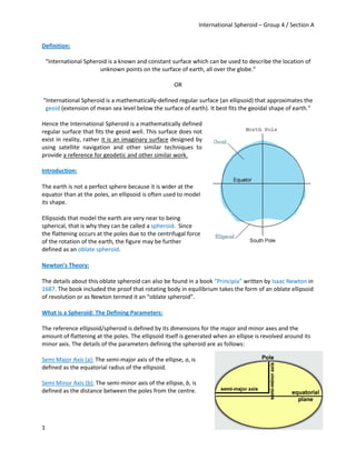
- 1. International Spheroid – Group 4 / Section A 1 Definition: “International Spheroid is a known and constant surface which can be used to describe the location of unknown points on the surface of earth, all over the globe.” OR “International Spheroid is a mathematically-defined regular surface (an ellipsoid) that approximates the geoid (extension of mean sea level below the surface of earth). It best fits the geoidal shape of earth.” Hence the International Spheroid is a mathematically defined regular surface that fits the geoid well. This surface does not exist in reality, rather it is an imaginary surface designed by using satellite navigation and other similar techniques to provide a reference for geodetic and other similar work. Introduction: The earth is not a perfect sphere because it is wider at the equator than at the poles, an ellipsoid is often used to model its shape. Ellipsoids that model the earth are very near to being spherical, that is why they can be called a spheroid. Since the flattening occurs at the poles due to the centrifugal force of the rotation of the earth, the figure may be further defined as an oblate spheroid. Newton’s Theory: The details about this oblate spheroid can also be found in a book “Principia” written by Isaac Newton in 1687. The book included the proof that rotating body in equilibrium takes the form of an oblate ellipsoid of revolution or as Newton termed it an “oblate spheroid”. What is a Spheroid: The Defining Parameters: The reference ellipsoid/spheroid is defined by its dimensions for the major and minor axes and the amount of flattening at the poles. The ellipsoid itself is generated when an ellipse is revolved around its minor axis. The details of the parameters defining the spheroid are as follows: Semi Major Axis (a): The semi-major axis of the ellipse, a, is defined as the equatorial radius of the ellipsoid. Semi Minor Axis (b): The semi-minor axis of the ellipse, b, is defined as the distance between the poles from the centre.
- 2. International Spheroid – Group 4 / Section A 2 Flattening: Flattening is a measure of the compression of a circle or sphere along a diameter to form an ellipsoid of revolution or a spheroid. The flattening, f, is defined as; f = where a= major axis b= minor axis In practice geodesy publications classify reference ellipsoids and spheroids by giving the semi-major axis and the inverse flattening (1/f). The Need of International Spheroid: The main purpose of defining a spheroid internationally and locally is mapping of the surface of earth and determining its shape. In Survey work, the reference ellipsoid is of greater importance. It is extensively used in geodetic survey. International Spheroid provides a global reference that best fits the earth. It is beneficial because it provides a reference for ITRS (International Terrestrial Reference System), GNSS (Global Navigation Satellite System) and GPS (Global Positioning System). The need of an International Spheroid is not a need of today. An International Spheroid for the whole world became essential in the 1950s for several reasons: International space science and the beginning of astronautics. The lack of inter-continental geodetic information. The inability of the large geodetic systems, such as European Datum (ED50), North American Datum (NAD), and Tokyo Datum(TD), to provide a worldwide geo-data basis Need for global maps for navigation, aviation, and geography. Before the development of International Spheroid, various ‘local’ spheroids were developed. These spheroids were not suitable for the mapping of the earth because they did not fit the complete earth well. They only fit those parts of the world for which they were designed and hence they could not be used for global mapping. Some of the major local spheroids developed in history are as follows; Ellipsoid a (meters) 1/f Where Used Airy (1830) 6 377 563 299.3 Great Britain Everest (1830) 6 377 276 300.8 Pakistan, India Bessel (1841) 6 377 397 299.2 East Indies, Japan Clarke (1866) 6 378 206 295.0 North & Central America Australian National (1965) 6 378 160 298.2 Australia South American (1969) 6 378 160 298.2 South America
- 3. International Spheroid – Group 4 / Section A 3 The flow sheet representation of Various Regional and International Spheroids is as follows; History of International Spheroid: In 1906, German geodesist Friedrich Robert Helmert attempted to do so and came up with the idea that the earth was a triaxial ellipsoid based on his knowledge of the distribution of the gravitational force of the earth. The Helmert Ellipsoid, the first global ellipsoid (semi-major axis a = 6,378,200 m ; flattening =1/ 298.3) closely resembles the WGS 84, the standard ellipsoid today. The idea that the earth is a triaxial ellipsoid remains a theory today and is very controversial in the field of Geodesy. The Helmert Ellipsoid, although accurate, was largely unnoticed as other work by Helmert in the field of Geodesy gained prominence. Contributions by John Fillmore Hayford: A frequently-used official Earth ellipsoid was defined in 1924, when the International Union of Geodesy and Geophysics (IUGG) adopted a flattening of exactly 1 /297 and a semi-major axis (or Equatorial radius) of exactly 6,378,388 m. The radius of the Earth along the polar axis is then 1/297 less than 6,378,388 or approximately 6,356,911.9 m. This is called the International ellipsoid and is based on John Fillmore Hayford’s calculations in 1910 from U.S. Coast and Geodetic Survey measurements made entirely within the United States. Before World War I, ellipsoids like Clarke 1866, Airy 1830 and Bessel 1840 were used for geodetic network computations and mapping. All of these
- 4. International Spheroid – Group 4 / Section A 4 ellipsoids, however, were regional or local i.e. they were best fitted to certain areas and countries e.g. the Clarke 1866 was used when mapping North America. In order to practice Geodesy at a Global Level, an ellipsoid that best approximated the shape of the earth had to be designed. The Hayford Ellipsoid as it was originally called was first introduced in 1910 and was used primarily in the USA. Named after John Fillmore Hayford (Born May 19, 1868, in Rouses Point, N.Y.; died Mar. 10, 1925, in Evanston, 111), an American Geodesist, the spheroid was not adopted internationally until 1924 when the International Union of Geodesy and Geophysics made it a standard for Geodesy on a Global level. The ellipsoid was developed by Hayford using the theory of isostasy i.e. the theory that serves as an explanation for elevation differences seen on the earth’s crust or on the lithosphere. Hayford also relied on arc measurements covering the USA to design the ellipsoid. The development of the ellipsoid took three years of work; from 1906 to 1909. During this period, Hayford was a member of the US Coast and Geodetic survey. Drawbacks: The Hayford Ellipsoid, although recommended for international use, was not accurate enough when mapping Western Europe and South America simultaneously. The Ellipsoid had to be adjusted to better fit each of these areas when Geodetic survey of these areas and surrounding areas was performed. This problem arose because the Hayford Ellipsoid was not an earth-centered ellipsoid i.e. it did not coincide with the centre of mass of the earth. It is due to this that the Hayford Ellipsoid or the International Ellipsoid 1924 was not widely used and many countries chose to retain older ellipsoid models for geodetical measurements. GRS-80: GRS-80 was the first International Spheroid adopted at the XVII General Assembly of the International Union of Geodesy and Geophysics (IUGG). The Parameters of GRS-80 are as follows; Semi Major Axis = Equatorial Radius= 6 378 137 m Semi Minor Axis= Polar Radius= 6 356 752. 314 14 m Flattening= 1/298.257 222 101. More than 30 years ago, satellites began acquiring remote imagery. As GPS, a satellite-based location system, matured and became accessible to the public, the need to extend and better define the earth's spheroid and associated datums became more pressing. In 1980, a new spheroid, the Geodetic Reference System (GRS80), was developed from satellite measurements. Instead of defining the earth from surface measurements linked horizontally and related vertically to mean sea level, this new mathematical approximation was derived from a point located out in space.
- 5. International Spheroid – Group 4 / Section A 5 This spheroid and its associated datums define the earth's shape by measuring and triangulating from an outside perspective and use the mass center of the earth as an absolute origin. Using the GRS80 spheroid, new datums were developed both regionally and worldwide. The North American Datum of 1983 (NAD83) and the World Geodetic System of 1984 (WGS84) are examples of these new datums. Worldwide, all GPS measurements are now based on the WGS84 datum. The most precise global geoid is the Earth’s Gravitational Model 1996 (EGM96). However it still remains a complex undulating figure which varies from GRS-80 ellipsoid by more than 100 m in places. In UK, the geoid-ellipsoid separation is as much as 57 m in the region of Hebrides.
- 6. International Spheroid – Group 4 / Section A 6 Present International Spheroid: WGS-84: History of WGS – 84: As described before the need for development and establishment of International Spheroid become more prominent in the 19th Century, after a global ellipsoid by John Fillmore Hayford was derived in 1910-1924. WGS – 60: The First Seed: In the late 1950s, the United States Department of Defense (DoD), along with scientists of other institutions and countries, began to develop the needed World Geodetic System to which geodetic data could be referred and compatibility established between the coordinates of widely separated sites of interest. Efforts of the U.S. Army, Navy and Air Force were combined which resulted in introduction of World Geodetic System 1960 (WGS 60). In accomplishing WGS 60, a combination of available surface gravity data*, astro-geodetic data** and results from HIRAN (High Precision Short Range Navigation) and Canadian SHORAN (SHOrt RAnge Navigation) surveys were used to define a best-fitting ellipsoid. The sole contribution of satellite data to the development of WGS 60 was a value for the ellipsoid flattening which was obtained from the nodal motion of a satellite. WGS – 66: The Improvement: In January 1966, a World Geodetic System Committee composed of representatives from the United States Army, Navy and Air Force, was charged with the responsibility of developing an improved WGS needed to satisfy mapping, charting and geodetic requirements. Additional surface gravity observations, results from the extension of triangulation and trilateration networks, and large amounts of optical satellite*** data had become available since the development of WGS 60. Using the additional data and improved techniques, WGS 66 was produced which served for about five years after its implementation in 1967. WGS – 72: The Step Ahead: After an extensive effort extending over a period of approximately three years, selected satellite, surface gravity and astro-geodetic data available through 1972 from both DoD (Department of Defense) and non-DoD sources were used in a Unified WGS Solution. * The measurement of the differences in gravity force at two or more points. ** Astro-geodetic data is the data obtained through various important methods in geodesy, satellite techniques and astrometry. *** Optical data transmission through free space, usually through air or vacuum via optical fibers
- 7. International Spheroid – Group 4 / Section A 7 The largest collection of data ever used for WGS purposes was assembled, processed and applied in the development of WGS 72. Both optical and electronic satellite data were used. WGS – 84: The Final Product: In the early 1980s the need for a new world geodetic system was generally recognized by the geodetic community, also within the US Department of Defense. WGS 72 no longer provided sufficient data, information, geographic coverage, or product accuracy for all then current and anticipated applications. The means for producing a new WGS were available in the form of improved data, increased data coverage, new data types and improved techniques. GRS 80 parameters, satellite laser ranging and Very Long Baseline Interferometry (VLBI)* observations constituted significant new information. An outstanding new source of data had become available from satellite radar altimetry**. Also available was an advanced least squares method*** called collocation which allowed for a consistent combination solution from different types of measurements all relative to the Earth's gravity field, i.e. geoid, gravity anomalies, deflections etc. The new World Geodetic System was called WGS 84. It is currently the reference system being used by the Global Positioning System. It is geocentric and globally consistent within ±1 m. Defining Parameters: The defining parameters/characteristics of WGS-84 are as follows: Semi Major Axis (Equatorial Radius) = a = 6 378 137 m Semi Minor Axis (Polar Radius) = b = 6 356 752. 3142 m Flattening (f) = 1 / 298. 257 223 563 WGS-84 is the spheroid which is used throughout the world now-a-days. The co ordinate origin of WGS 84 is the Earth’s Center of Mass. Because of this the error in calculations done using the WGS – 84 is less then 2cm. WGS – 84 uses EGM96 (Earth Gravitational Model 1996) as its geoid. * VLBI In radio astronomy, a system of two or more antennas placed several hundred or several thousand miles apart, which are operated together as an interferometer. ** measurement of altitude via satellites *** The method of least squares is a standard approach to the approximate solution of over determined systems, i.e., sets of equations in which there are more equations than unknowns
- 8. International Spheroid – Group 4 / Section A 8 Techniques for Determining the Spheroid: Following is a brief introduction of the techniques employed for acquiring sufficient data for determining the position of International Spheroid: VLBI (Very-long-baseline Interferometry): Very-long-baseline Interferometry (VLBI) is a type of astronomical Interferometry used in radio astronomy. It allows observations of an object that are made simultaneously by many telescopes to be combined, emulating a telescope with a size equal to the maximum separation between the telescopes. Data received at each antenna in the array is paired with timing information, usually from a local atomic clock, and then stored for later analysis on magnetic tape or hard disk. At that later time, the data is correlated with data from other antennas similarly recorded, to produce the resulting image. Data collected via VLBI has been a major source of information for the development of WGS – 84. On the other hand, VLBI is most well known for imaging distant cosmic radio sources, spacecraft tracking, and for applications in astrometry. Altimetry: An altimeter or an altitude meter is an instrument used to measure the altitude of an object above a fixed level. The measurement of altitude is called altimetry. Satellite radar altimetry provides height measurements of the instantaneous surface (sea, ice, or open water on land) with respect to a fixed reference (typically a conventional reference ellipsoid embedded in a global reference frame): the on board radar altimeter transmits a short pulse of microwave radiation with known power towards the nadir. Part of the incident radiation reflects back to the altimeter. Measurement of the round trip radar signal travel time provides the height of the satellite (altimetric range) above the instantaneous sea/land water/ice surface. Its difference with the satellite altitude above the reference ellipsoid (computed through precise orbit determination, a long-tested approach in space geodesy) gives sea/land water/ice surface height measurements with respect to the reference.
- 9. International Spheroid – Group 4 / Section A 9 The technique of altimetry has been employed for determining the appropriate position of World Geodetic System (1960-1984). Future of International Spheroid: The future of technological advancements is far beyond our imagination. Many extraordinary researches and developments are already in progress such a masterpiece is the GGOS-20 (Global Geodetic Observation System 2020). A project of immense capabilities and scale commenced in 2011, it is the prediction of centuries of work and developments in the field of geodesy. A brief overview of its capabilities and importance of an updated, universally accepted and continuously monitored International reference system for the GGOS is discussed below Global Geodetic Observation System 2020: GGOS is a complex system, addressing relevant geodetic, geodynamic and geophysical problems, which have deep impact on vital issues concerning humankind, e.g., global change, sea level rise, global water circulation, water supply, natural disasters, risk reduction, etc. It is a visionary concept based on the requirements and specifications such as land, air, sea navigation global positioning and space exploration and on the assessment of what components are needed to fulfill the very demanding goals. To address the ambitious goals of GGOS, IGA will integrate a multitude of sensors into one global observing system, where all the instruments will work together like one extremely complex sensor. In the following sections the focus will be on the technical design and rational for the future overall GGOS system. The individual parts of the system will be discussed and the interaction between the components will be outlined, from the geodetic observations and the interfaces to the products for the users.
- 10. International Spheroid – Group 4 / Section A 10 Uses / Applications of International Spheroid: GPS: The Global Positioning System (GPS) is a space-based satellite navigation system that provides location and time information in all weather, anywhere on or near the Earth, where there is an unobstructed line of sight to four or more GPS satellites. It is maintained by the United States government and is freely accessible to anyone with a GPS receiver. The GPS uses the International Spheroid as its reference system. The GPS program provides critical capabilities to military, civil and commercial users around the world. In addition, GPS is the backbone for modernizing the global air traffic system. The GPS project was developed in 1973 to overcome the limitations of previous navigation systems, integrating ideas from several predecessors, including a number of classified engineering design studies from the 1960s. GPS was created and realized by the U.S. Department of Defense (DoD) and was originally run with 24 satellites. It became fully operational in 1994. Advances in technology and new demands on the existing system have now led to efforts to modernize the GPS system and implement the next generation of GPS III satellites and Next Generation Operational Control System (OCX). Announcements from the Vice President and the White House in 1998 initiated these changes. In 2000, U.S. Congress authorized the modernization effort, referred to as GPS III. GNSS: Using the International Spheroid as its reference system, satellite navigation or SAT NAV system is a system of satellites that provide autonomous geo-spatial positioning with global coverage. It allows small electronic receivers to determine their location (longitude, latitude, and altitude) to within a few meters using time transmitted along a line-of-sight by radio from satellites. Receivers calculate the precise time as well as position, which can be used as a reference for scientific experiments. A satellite navigation system with global coverage may be termed a global navigation satellite system or GNSS.
- 11. International Spheroid – Group 4 / Section A 11 GNSS-1 is the first generation system and is the combination of existing satellite navigation systems (GPS and GLONASS), with Satellite Based Augmentation Systems (SBAS) or Ground Based Augmentation Systems (GBAS). In the United States, the satellite based component is the Wide Area Augmentation System (WAAS), in Europe it is the European Geostationary Navigation Overlay Service (EGNOS), and in Japan it is the Multi-Functional Satellite Augmentation System (MSAS). Ground based augmentation is provided by systems like the Local Area Augmentation System (LAAS). ITRS The International Terrestrial Reference System (ITRS) constitutes a set of prescriptions and conventions together with the modeling required to define origin, scale, orientation and time evolution of a Conventional Terrestrial Reference System (CTRS). The ITRS is an ideal reference system, as defined by the IUGG resolution No. 2 adopted in Vienna, 1991. The system is realized by the International Terrestrial Reference Frame (ITRF) based upon estimated coordinates and velocities of a set of stations observed by VLBI, LLR, GPS, SLR, and DORIS. The ITRS can be connected to the International Celestial Reference System (ICRS) by use of the IERS Earth Orientation Parameters (EOP). Following are the various Reference frameworks established under the subsequent reference system mentioned earlier ITRF (International Terrestrial Reference Frame): The International Terrestrial Reference Frame (ITRF) is a set of points with their 3-dimensional Cartesian coordinates which realize an ideal reference system, the International Terrestrial Reference System (ITRS), as defined by the IUGG resolution No. 2 adopted in Vienna, 1991. Following is the list of terrestrial frames designed over the years; A. ITRF89 B. ITRF90 C. ITRF91 D. ITRF92 E. ITRF93 F. ITRF94 G. ITRF95 H. ITRF96 I. ITRF97 J. ITRF2000 K. ITRF2005 L. ITRF2008
- 12. International Spheroid – Group 4 / Section A 12 References: I. http://en.wikipedia.org/wiki/World_Geodetic_System II. http://en.wikipedia.org/wiki/Hayford_ellipsoid III. http://www.esri.com/news/arcuser/0401/datum.html IV. http://www.gmat.unsw.edu.au/snap/gps/gps_survey/chap2/214.htm V. http://www.wsmr.army.mil/pdf/G1674-Upgrade-01Jul2012.pdf VI. http://www.profsurv.com/magazine/article.aspx VII. http://en.wikipedia.org/wiki/Figure_of_the_Earth VIII. http://en.wikipedia.org/wiki/Earth_ellipsoid IX. http://www.georeference.org/doc/the_earth_as_an_ellipsoid.htm X. http://kartoweb.itc.nl/geometrics/reference%20surfaces/refsurf.html XI. http://encyclopedia2.thefreedictionary.com/international+ellipsoid+of+reference XII. http://en.wikipedia.org/wiki/North_American_Datum XIII. http://geography.about.com/od/geographyintern/a/datums.htm XIV. http://www.ggos.org/ XV. http://192.106.234.28/HOME/Intro.html XVI. http://www.evlbi.org/ XVII. http://en.wikipedia.org/wiki/Very-long-baseline_interferometry XVIII. http://www.georeference.org/doc/the_earth_as_an_ellipsoid.htm