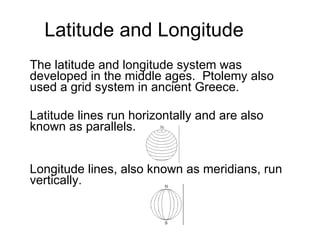
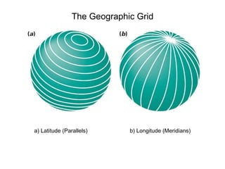
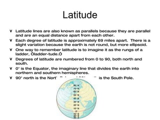
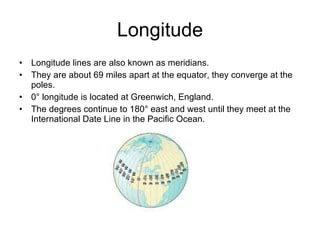
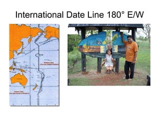
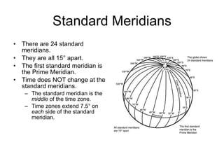
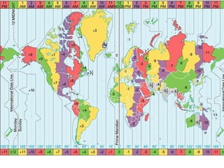
The document discusses the concepts of latitude, longitude, time zones, and how locations on Earth are specified using these coordinate systems. It explains that latitude lines run parallel east-west and longitude lines run perpendicular north-south, with the Prime Meridian at Greenwich, England defining 0 degrees. It describes how the Earth is divided into 24 time zones that are approximately 15 degrees wide to standardized time globally.
A time zone is a region of the globe that observes a uniform standard time for legal, commercial, and social purposes.
The International Date Line (IDL) is an imaginary line of demarcation on the surface of the Earth that runs from the North Pole to the South Pole and demarcates the change of one calendar day to the next.
This is slide show created based on a tutorial hosted by Geography World and created by Mr. Bowerman. All credit for images and information go to them. I created this for use in a 4/5 grade gifted social studies and math lesson.
Lines of Latitude and Longitude – PowerPointYaryalitsa
PowerPoint on Lines of Latitude, Lines of Longitude, Climate Zones, Equinoxes, Solstices, The Three Norths, Prime Meridian, International Date Line, Greenwich Mean Time, Coordinated Universal Time.
Lines of Latitude and Longitude – Worksheet at:
http://www.slideshare.net/yaryalitsa/lines-of-latitude-and-longitude-worksheet
How Great Leaders Inspire Action
Sources:
Sinek, S. Start With Why: How Great Leaders Inspire Everyone to Take Action. Portfolio
Hardcover: New York, 2009.
Sinek, S. (2010, May 1). Simon Sinek: How great leaders inspire action | Video on TED.com.
TED: Ideas worth spreading. Retrieved September 14, 2012, from http://
www.ted.com/talks/simon_sinek_how_great_leaders_inspire_action.html
This PowerPoint is one small part of the Astronomy Topics unit from www.sciencepowerpoint.com. This unit consists of a five part 3000+ slide PowerPoint roadmap, 12 page bundled homework package, modified homework, detailed answer keys, 8 pages of unit notes for students who may require assistance, follow along worksheets, and many review games. The homework and lesson notes chronologically follow the PowerPoint slideshow. The answer keys and unit notes are great for support professionals. The activities and discussion questions in the slideshow and meaningful. The PowerPoint includes built-in instructions, visuals, and follow up questions. Also included are critical class notes (color coded red), project ideas, video links, and review games. This unit also includes four PowerPoint review games (110+ slides each with Answers), 38+ video links, lab handouts, activity sheets, rubrics, materials list, templates, guides, and much more. Also included is a 190 slide first day of school PowerPoint presentation. Teaching Duration = 5+ weeks. Areas of Focus in the Astronomy Topics Unit: The Solar System and the Sun, Order of the Planets, Our Sun, Life Cycle of a Star, Size of Stars, Solar Eclipse, Lunar Eclipse, The Inner Planets, Mercury, Venus, Earth, Moon, Craters, Tides, Phases of the Moon, Mars and Moons, Rocketry, Asteroid Belt, NEOs, The Torino Scale, The Outer Planets and Gas Giants, Jupiter / Moons, Saturn / Moons, Uranus / Moons, Neptune / Moons, Pluto's Demotion, The Kuiper Belt, Oort Cloud, Comets / Other, Beyond the Solar System, Types of Galaxies, Blackholes, Extrasolar Planets, The Big Bang, Dark Matter, Dark Energy, The Special Theory of Relativity, Hubble Space Telescope, Constellations, Spacetime and much more. If you have any questions please feel free to contact me. Thanks again and best wishes. Sincerely, Ryan Murphy M.Ed www.sciencepowerpoint@gmail.com
The geographic coordinate system is a spherical or ellipsoidal coordinate system for measuring and communicating positions directly on the Earth as latitude and longitude. It is the simplest, oldest and most widely used of the various spatial reference systems that are in use, and forms the basis for most others
2. Latitude and Longitude The latitude and longitude system was developed in the middle ages. Ptolemy also used a grid system in ancient Greece. Latitude lines run horizontally and are also known as parallels. Longitude lines, also known as meridians, run vertically.
20. International Date Line Ferdinand Magellan and crew in 1519 set out on their westward journey from Spain to circumnavigate the Earth. Upon their return three years later, they discovered that their meticulously kept logs were off by one day. This was one of the first recorded experience with changing global time. This earlier experience would ultimately lead to the establishment of the international date line. The International Date Line lies directly opposite of the prime meridian and having a longitude of 180°. Crossing the line when traveling east one turns their calendar back a full day. Traveling west one moves their calendar forward one day. http://www.danstopicals.com/dateline.htm
21.
22.
23. US Time Zones This map does NOT include Alaskan or Hawaiian time zones. Atlantic Standard Time and Newfoundland are NOT in the US, they are Canadian.