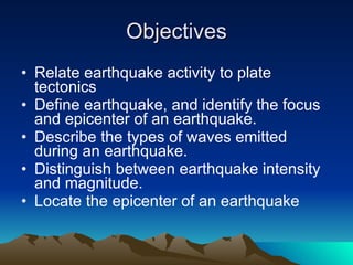
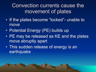
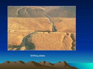
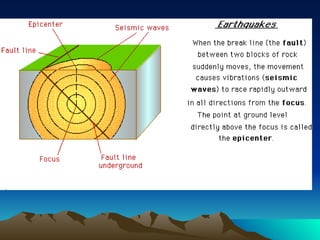
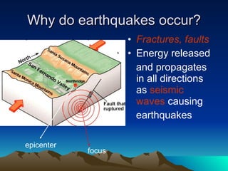
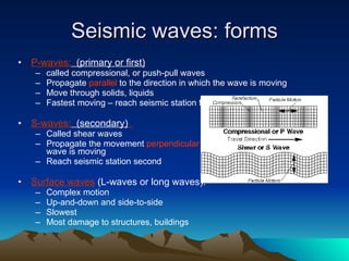
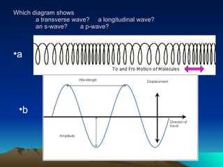
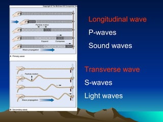
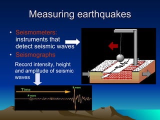
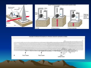
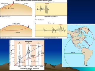
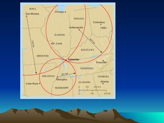
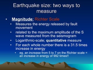
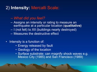
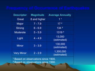
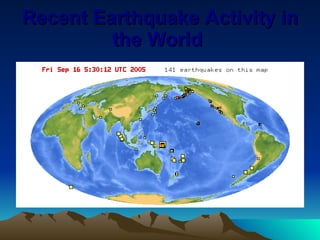
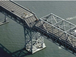
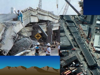
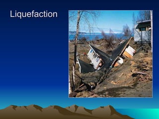
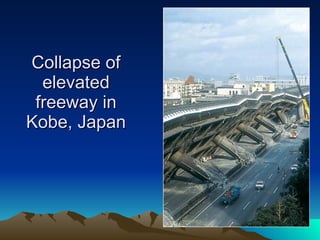
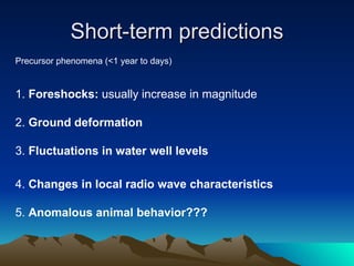
Earthquakes
Objectives Relate earthquake activity to plate tectonics  Define earthquake, and identify the focus and epicenter of an earthquake.  Describe the types of waves emitted during an earthquake.  Distinguish between earthquake intensity and magnitude.  Locate the epicenter of an earthquake
Convection currents cause the movement of plates If the plates become “locked”- unable to move Potential Energy (PE) builds up  PE may be released as KE and the plates move abruptly apart This sudden release of energy is an earthquake
Shifting plates
 
Why do earthquakes occur? Fractures, faults Energy released and propagates in all directions as  seismic waves  causing earthquakes focus epicenter
Where do earthquakes occur: 1) Most earthquakes occur along the edge of the  oceanic  and  continental plate 2) Along  faults:  normal, reverse, transform
definitions Earthquake  = Vibration of the Earth produced by the rapid release of energy Seismic waves  = Energy moving outward from the focus of an earthquake  Focus =  location of initial slip on the fault; where the earthquake origins Epicenter = spot on Earth’s surface directly above the focus
Seismic waves: forms P-waves:   (primary or first) called compressional, or push-pull waves Propagate  parallel  to the direction in which the wave is moving Move through solids, liquids Fastest moving – reach seismic station first S-waves:   (secondary)   Called shear waves Propagate the movement  perpendicular  to the direction in which the wave is moving Reach seismic station second Surface waves  (L-waves or long waves). Complex motion Up-and-down and side-to-side Slowest Most damage to structures, buildings
Which diagram shows a transverse wave?  a longitudinal wave?  an s-wave? a p-wave? b a
Longitudinal wave P-waves Sound waves Transverse wave S-waves Light waves
Measuring earthquakes Seismometers:  instruments that detect seismic waves Seismographs Record intensity, height  and amplitude of seismic  waves
 
Locating the shaking Measure time between P and S waves on a seismogram Need at least 3 seismographs
 
 
Earthquake size: two ways to measure Magnitude :   Richter Scale Measures the energy released by fault movement related to the maximum amplitude of the S wave measured from the seismogram Logarithmic-scale;  quantitative  measure For each whole number there is a 31.5 times increase in energy eg. an increase from 5 to 7 on the Richter scale = an increase in energy of 992 times!!
2)  Intensity:   Mercalli Scale: What did you feel? Assigns an intensity or rating to measure an earthquake at a particular location ( qualitative) I (not felt) to XII (buildings nearly destroyed) Measures the destructive effect Intensity is a function of: Energy released by fault Geology of the location Surface substrate: can magnify shock waves e.g. Mexico City (1985) and San Francisco (1989)
Frequency of Occurrence of Earthquakes  ¹ Based on observations since 1900.  ² Based on observations since 1990.  1,300,000 (estimated) 2 - 2.9  Very Minor  130,000 (estimated) 3 - 3.9  Minor  13,000 (estimated) 4 - 4.9  Light  1319 ² 5 - 5.9  Moderate  134 ²  6 - 6.9  Strong  17 ²  7 - 7.9  Major  1 ¹ 8 and higher Great Average Annually  Magnitude  Descriptor
Recent Earthquake Activity in the World
Largest earthquake in the world Chile : 1960 May 22 19:11:14 UTC  Magnitude 9.5  More than 2,000 killed, 3,000 injured, 2,000,000 homeless, and $550 million damage in southern Chile tsunami caused 61 deaths $75 million damage in Hawaii; 138 deaths and $50 million damage in Japan;  32 dead and missing in the Philippines;  and $500,000 damage to the west coast of  the United States.
 
Most Destructive Known Earthquakes on Record in the World  166,836 injured,  600,000 homeless .  7.7 20,023   India 2001 Jan 26  Estimated death toll as high as 30,000 Old lake bed magnified shock waves by 500% 8.0   9500 (official) Mexico Michoacan Sept 19, 1985 Estimated death toll as high as 655,000. 7.5 255,000 (official) China,  Tangshan July 27, 1976 $530,000,000 damage, great rock slide, floods. 7.9 66,000 Peru May 31, 1970 Deaths from earthquake  and tsunami 9.0 283,106 Sumatra  2004 Dec 26  Comments Magnitude Deaths Location Date
Earthquake damage Ground Failure  - constructions collapse Fires  - from broken gas and electrical lines Landslides  - EQ's triggered; occur in hilly/mountainous areas.  Liquefaction  - water-saturated, unconsolidated materials flow  Tsunami  (seismic sea waves; "tidal" waves) - can grow up to 65 m
Earthquakes and the San Andreas Fault 
 
 
Liquefaction
Collapse of elevated freeway in Kobe, Japan
Generating a tsunami
Landslides: May 30, 1970 Peru disaster Magnitude: 7.9  A large mass of ice and rock slid from a vertical face on Nevado Huascaran, the highest peak in Peru Debris reached a velocity of 280 km/hr traveled 11 km horizontally in about 4 minutes at a mean velocity of 165 km/hr.  Buried the towns of Yungay and Ranrahirca, The death toll in both villages was 20,000.
The town of Huaraz flattened
India, Gujarat earthquake Jan 26, 2001
Jun 23, 2001 S.Peru earthquake Arequipa
San Francisco 1906
Earthquake risk and prediction Long-term methods 1)   seismic hazard maps 2) probability analysis based on:  - historical EQ records  - geologic EQ records  - slip-rate on active faults  - frequency and magnitude of recent EQ's Real-time 24 Hour Forecast
Short-term predictions Precursor phenomena (<1 year to days) 1.  Foreshocks:  usually increase in magnitude  2.  Ground deformation 3.  Fluctuations in water well levels 4.  Changes in local radio wave characteristics  5.  Anomalous animal behavior???
Impacts of Earthquake Prediction

Earthquakes

  • 1.
  • 2.
    Objectives Relate earthquakeactivity to plate tectonics Define earthquake, and identify the focus and epicenter of an earthquake. Describe the types of waves emitted during an earthquake. Distinguish between earthquake intensity and magnitude. Locate the epicenter of an earthquake
  • 3.
    Convection currents causethe movement of plates If the plates become “locked”- unable to move Potential Energy (PE) builds up PE may be released as KE and the plates move abruptly apart This sudden release of energy is an earthquake
  • 4.
  • 5.
  • 6.
    Why do earthquakesoccur? Fractures, faults Energy released and propagates in all directions as seismic waves causing earthquakes focus epicenter
  • 7.
    Where do earthquakesoccur: 1) Most earthquakes occur along the edge of the oceanic and continental plate 2) Along faults: normal, reverse, transform
  • 8.
    definitions Earthquake = Vibration of the Earth produced by the rapid release of energy Seismic waves = Energy moving outward from the focus of an earthquake Focus = location of initial slip on the fault; where the earthquake origins Epicenter = spot on Earth’s surface directly above the focus
  • 9.
    Seismic waves: formsP-waves: (primary or first) called compressional, or push-pull waves Propagate parallel to the direction in which the wave is moving Move through solids, liquids Fastest moving – reach seismic station first S-waves: (secondary) Called shear waves Propagate the movement perpendicular to the direction in which the wave is moving Reach seismic station second Surface waves (L-waves or long waves). Complex motion Up-and-down and side-to-side Slowest Most damage to structures, buildings
  • 10.
    Which diagram showsa transverse wave? a longitudinal wave? an s-wave? a p-wave? b a
  • 11.
    Longitudinal wave P-wavesSound waves Transverse wave S-waves Light waves
  • 12.
    Measuring earthquakes Seismometers: instruments that detect seismic waves Seismographs Record intensity, height and amplitude of seismic waves
  • 13.
  • 14.
    Locating the shakingMeasure time between P and S waves on a seismogram Need at least 3 seismographs
  • 15.
  • 16.
  • 17.
    Earthquake size: twoways to measure Magnitude : Richter Scale Measures the energy released by fault movement related to the maximum amplitude of the S wave measured from the seismogram Logarithmic-scale; quantitative measure For each whole number there is a 31.5 times increase in energy eg. an increase from 5 to 7 on the Richter scale = an increase in energy of 992 times!!
  • 18.
    2) Intensity: Mercalli Scale: What did you feel? Assigns an intensity or rating to measure an earthquake at a particular location ( qualitative) I (not felt) to XII (buildings nearly destroyed) Measures the destructive effect Intensity is a function of: Energy released by fault Geology of the location Surface substrate: can magnify shock waves e.g. Mexico City (1985) and San Francisco (1989)
  • 19.
    Frequency of Occurrenceof Earthquakes ¹ Based on observations since 1900. ² Based on observations since 1990. 1,300,000 (estimated) 2 - 2.9 Very Minor 130,000 (estimated) 3 - 3.9 Minor 13,000 (estimated) 4 - 4.9 Light 1319 ² 5 - 5.9 Moderate 134 ² 6 - 6.9 Strong 17 ² 7 - 7.9 Major 1 ¹ 8 and higher Great Average Annually Magnitude Descriptor
  • 20.
  • 21.
    Largest earthquake inthe world Chile : 1960 May 22 19:11:14 UTC Magnitude 9.5 More than 2,000 killed, 3,000 injured, 2,000,000 homeless, and $550 million damage in southern Chile tsunami caused 61 deaths $75 million damage in Hawaii; 138 deaths and $50 million damage in Japan; 32 dead and missing in the Philippines; and $500,000 damage to the west coast of the United States.
  • 22.
  • 23.
    Most Destructive KnownEarthquakes on Record in the World 166,836 injured, 600,000 homeless . 7.7 20,023 India 2001 Jan 26 Estimated death toll as high as 30,000 Old lake bed magnified shock waves by 500% 8.0   9500 (official) Mexico Michoacan Sept 19, 1985 Estimated death toll as high as 655,000. 7.5 255,000 (official) China,  Tangshan July 27, 1976 $530,000,000 damage, great rock slide, floods. 7.9 66,000 Peru May 31, 1970 Deaths from earthquake and tsunami 9.0 283,106 Sumatra 2004 Dec 26 Comments Magnitude Deaths Location Date
  • 24.
    Earthquake damage GroundFailure - constructions collapse Fires - from broken gas and electrical lines Landslides - EQ's triggered; occur in hilly/mountainous areas. Liquefaction - water-saturated, unconsolidated materials flow Tsunami (seismic sea waves; &quot;tidal&quot; waves) - can grow up to 65 m
  • 25.
    Earthquakes and theSan Andreas Fault 
  • 26.
  • 27.
  • 28.
  • 29.
    Collapse of elevatedfreeway in Kobe, Japan
  • 30.
  • 31.
    Landslides: May 30,1970 Peru disaster Magnitude: 7.9 A large mass of ice and rock slid from a vertical face on Nevado Huascaran, the highest peak in Peru Debris reached a velocity of 280 km/hr traveled 11 km horizontally in about 4 minutes at a mean velocity of 165 km/hr. Buried the towns of Yungay and Ranrahirca, The death toll in both villages was 20,000.
  • 32.
    The town ofHuaraz flattened
  • 33.
  • 34.
    Jun 23, 2001S.Peru earthquake Arequipa
  • 35.
  • 36.
    Earthquake risk andprediction Long-term methods 1) seismic hazard maps 2) probability analysis based on: - historical EQ records - geologic EQ records - slip-rate on active faults - frequency and magnitude of recent EQ's Real-time 24 Hour Forecast
  • 37.
    Short-term predictions Precursorphenomena (<1 year to days) 1. Foreshocks: usually increase in magnitude 2. Ground deformation 3. Fluctuations in water well levels 4. Changes in local radio wave characteristics 5. Anomalous animal behavior???
  • 38.

Editor's Notes

  • #7 Why do rock break? Review three types of stress: tension, compression, shear Three types of deformation resulting: elastic, plastic and brittle We’re concerned with the brittle deformation – causes faults, fractures through which energy, created by the friction, is released Define Focus, epicenter and seismic waves
  • #9 A drop of water – analogy between ripples in the water and seismic waves
  • #10 P-waves: the bell analogy: waves felt by both sound
  • #13 Earliest seismograph was invented in China ~ 2000 years ago (or 136 AD) Easy to make; can make your own at home
  • #18 Write Table 11-1 on the board, to help relate to Richter scale
  • #32 A large mass of ice and rock separated from a vertical face on Nevado Huascaran, the highest peak in Peru The slab fell 1000 m vertically, disintegrated, slid down the lateral slopes of the mountain, and then was launched off a &apos;ski jump&apos;. Debris reached a velocity as high as 280 km/hr buried the towns of Yungay and Ranrahirca, having traveled 11 km horizontally in about 4 minutes at a mean velocity of 165 km/hr. The death toll in both villages was 20,000.
  • #38 Animals and earthquakes: On February 4, 1975 the Chinese successfully evacuated the city of Haicheng several hours before a 7.3 magnitude earthquake-- based primarily on observations of unusual animal behavior. Conventional science has never been able to adequately explain the phenomenon. Although the majority of accounts pertain to dogs and cats, there are also many stories about other types of animals in the wild, on farms, and in zoos; including horses, cows, deer, goats, possums, rats, chickens, and other birds. The behavior has been reported in many other animal species as well, including fish, reptiles, and even insects. Deep sea fish, for example, have been caught close to the surface of the ocean on numerous occasions around Japan prior to earthquakes (Tributsch, 1982). A number of theories have been proposed to explain this phenomenon, and what the precursory signals that the animals are picking up on might be. Because many animals possess auditory capacities beyond the human range, it has been suggested that some animals may be reacting to ultrasound emitted as microseisms from fracturing rock (Armstrong, 1969). Another candidate is fluctuations in the earth&apos;s magnetic field. Because some animals have a sensitivity to variations in the earth&apos;s magnetic field (usually as a means of orientation), and since variations in the magnetic field occur near the epicenters of earthquakes (Chapman and Bartels, 1940), it has been suggested that this is what the animals are picking up on.