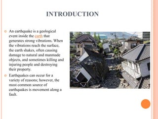
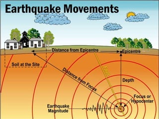
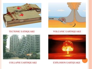
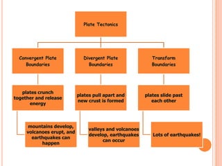
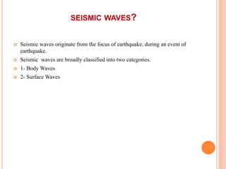
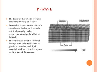
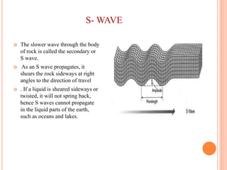
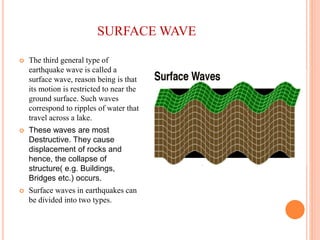
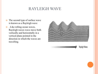
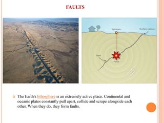
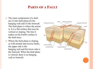
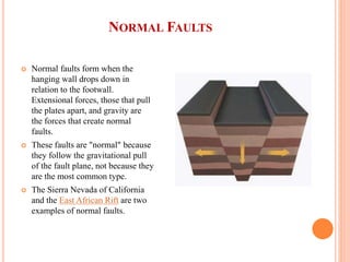
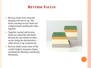
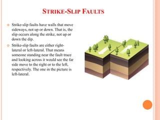
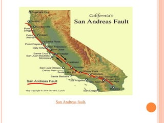
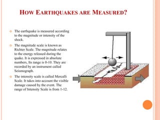
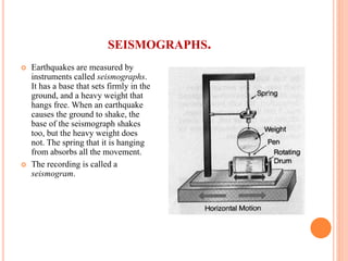
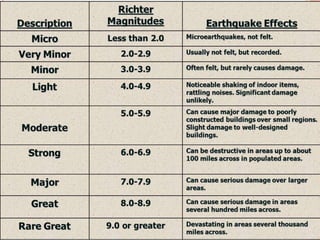
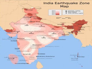
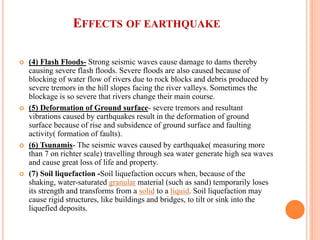
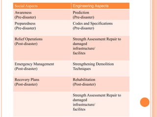
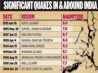
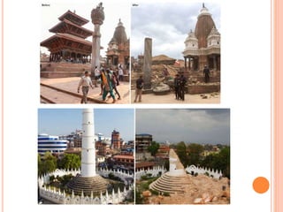
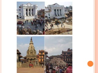
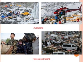
By : ISHA VARSHNEY
B.ARCH 3RD YEAR
INTRODUCTION
 An earthquake is a geological
event inside the earth that
generates strong vibrations. When
the vibrations reach the surface,
the earth shakes, often causing
damage to natural and manmade
objects, and sometimes killing and
injuring people and destroying
their property.
 Earthquakes can occur for a
variety of reasons; however, the
most common source of
earthquakes is movement along a
fault.
TECTONIC EATHQUAKE
COLLAPSE EARTHQUAKE
VOLCANIC EARTHQUAKE
EXPLOSION EARTQUAKE
TYPES OF AN EARTHQUAKE
 A tectonic earthquake is one that occurs when the earth's crust breaks due to
geological forces on rocks and adjoining plates that cause physical and
chemical changes.
 A volcanic earthquake is any earthquake that results from tectonic forces
which occur in conjunction with volcanic activity.
 Collapse Earthquakes are small earthquakes in the underground and in
mines that are caused by seismic waves produced from the explosion of
rock on the surface. The immediate cause of ground shaking is the collapse
of the roof of the mine or cavern. An often- observed variation of this
extraordinary event is called "mine burst".
 An explosion earthquake is an earthquake that is the result of the detonation
of a nuclear and/or chemical device.
Plate Tectonics
Convergent Plate
Boundaries
plates crunch
together and release
energy
mountains develop,
volcanoes erupt, and
earthquakes can
happen
Divergent Plate
Boundaries
plates pull apart and
new crust is formed
valleys and volcanoes
develop, earthquakes
can occur
Transform
Boundaries
plates slide past
each other
Lots of earthquakes!
SEISMIC WAVES?
 Seismic waves originate from the focus of earthquake, during an event of
earthquake.
 Seismic waves are broadly classified into two categories.
 1- Body Waves
 2- Surface Waves
BODY WAVES?
 Body waves are generated due to the release of energy at the focus
and move in all the directions travelling through the body of the
earth.
 There are two types of body waves. They are P and S waves.
P -WAVE
 The faster of these body waves is
called the primary or P wave.
 Its motion is the same as that of a
sound wave in that, as it spreads
out, it alternately pushes
(compresses) and pulls (dilates)
the rock.
 These P waves are able to travel
through both solid rock, such as
granite mountains, and liquid
material, such as volcanic magma
or the water of the oceans.
S- WAVE
 The slower wave through the body
of rock is called the secondary or
S wave.
 As an S wave propagates, it
shears the rock sideways at right
angles to the direction of travel
 . If a liquid is sheared sideways or
twisted, it will not spring back,
hence S waves cannot propagate
in the liquid parts of the earth,
such as oceans and lakes.
SURFACE WAVE
 The third general type of
earthquake wave is called a
surface wave, reason being is that
its motion is restricted to near the
ground surface. Such waves
correspond to ripples of water that
travel across a lake.
 These waves are most
Destructive. They cause
displacement of rocks and
hence, the collapse of
structure( e.g. Buildings,
Bridges etc.) occurs.
 Surface waves in earthquakes can
be divided into two types.
LOVE WAVE
 The first is called a Love wave.
 Its motion is essentially that of S
waves that have no vertical
displacement; it moves the ground
from side to side in a horizontal
plane but at right angles to the
direction of propagation.
 The horizontal shaking of Love
waves is particularly damaging to
the foundations of structures.
RAYLEIGH WAVE
 The second type of surface wave
is known as a Rayleigh wave
 . Like rolling ocean waves,
Rayleigh waves wave move both
vertically and horizontally in a
vertical plane pointed in the
direction in which the waves are
travelling.
SURFACE WAVE
 Surface waves travel more slowly than body waves (P and S); and of the
two surface waves.
 Love waves generally travel faster than Rayleigh waves.
 Love waves (do not propagate through water) can effect surface water only
insofar as the sides of lakes and ocean bays pushing water sideways like the
sides of a vibrating tank,
 whereas Rayleigh waves, because of their vertical component of their
motion can affect the bodies of water such as lakes.
FAULTS
 The Earth's lithosphere is an extremely active place. Continental and
oceanic plates constantly pull apart, collide and scrape alongside each
other. When they do, they form faults.
PARTS OF A FAULT
 The main components of a fault
are (1) the fault plane,(2) the
hanging wall and (3) the footwall.
The fault plane is where the action
is. It is a flat surface that may be
vertical or sloping. The line it
makes on the Earth's surface is
the fault trace.
 Where the fault plane is sloping,
as with normal and reverse faults,
the upper side is the
hanging wall and the lower side is
the footwall. When the fault plane
is vertical, there is no hanging
wall or footwall.
NORMAL FAULTS
 Normal faults form when the
hanging wall drops down in
relation to the footwall.
Extensional forces, those that pull
the plates apart, and gravity are
the forces that create normal
faults.
 These faults are "normal" because
they follow the gravitational pull
of the fault plane, not because they
are the most common type.
 The Sierra Nevada of California
and the East African Rift are two
examples of normal faults.
REVERSE FAULTS
 Reverse faults form when the
hanging wall moves up. The
forces creating reverse faults are
compressional, pushing the sides
together.
 Together, normal and reverse
faults are called dip-slip faults,
because the movement on them
occurs along the dip direction—
either down or up, respectively.
 Reverse faults create some of the
world's highest mountain chains,
including the Himalaya and Rocky
Mountains.
STRIKE-SLIP FAULTS
 Strike-slip faults have walls that move
sideways, not up or down. That is, the
slip occurs along the strike, not up or
down the dip.
 Strike-slip faults are either right-
lateral or left-lateral. That means
someone standing near the fault trace
and looking across it would see the far
side move to the right or to the left,
respectively. The one in the picture is
left-lateral.
San Andreas fault.
HOW EARTHQUAKES ARE MEASURED?
 The earthquake is measured according
to the magnitude or intensity of the
shock.
 The magnitude scale is known as
Richter Scale. The magnitude relates
to the energy released during the
quake. It is expressed in absolute
numbers, Its range is 0-10. They are
recorded by an instrument called
Seismograph.
 The intensity scale is called Mercalli
Scale. It takes into account the visible
damage caused by the event. The
range of Intensity Scale is from 1-12.
SEISMOGRAPHS.
 Earthquakes are measured by
instruments called seismographs.
It has a base that sets firmly in the
ground, and a heavy weight that
hangs free. When an earthquake
causes the ground to shake, the
base of the seismograph shakes
too, but the heavy weight does
not. The spring that it is hanging
from absorbs all the movement.
 The recording is called a
seismogram.
EFFECTS OF EARTHQUAKE
 (1) Damage to human structures - Earthquakes cause great damage to
human structures such as buildings, roads, rails, factories, dams, bridges etc,
and thus cause heavy damage to human property.
 (2) Landslides-The shocks produced by earthquakes particularly in hilly
areas and mountains which are tectonically sensitive causes landslides and
debris fall on human settlements and transport system on the lower slope
segments, inflicting damage to them.
 (3) Fires- The strong vibrations caused by severe earthquakes strongly
shake the buildings and thus causing severe fires in houses, mines and
factories because of overturning of cooking gas, contact of live electric
wires, churning of blast furnaces, displacement of other fire related and
electric appliances.
EFFECTS OF EARTHQUAKE
 (4) Flash Floods- Strong seismic waves cause damage to dams thereby
causing severe flash floods. Severe floods are also caused because of
blocking of water flow of rivers due to rock blocks and debris produced by
severe tremors in the hill slopes facing the river valleys. Sometimes the
blockage is so severe that rivers change their main course.
 (5) Deformation of Ground surface- severe tremors and resultant
vibrations caused by earthquakes result in the deformation of ground
surface because of rise and subsidence of ground surface and faulting
activity( formation of faults).
 (6) Tsunamis- The seismic waves caused by earthquake( measuring more
than 7 on richter scale) travelling through sea water generate high sea waves
and cause great loss of life and property.
 (7) Soil liquefaction -Soil liquefaction occurs when, because of the
shaking, water-saturated granular material (such as sand) temporarily loses
its strength and transforms from a solid to a liquid. Soil liquefaction may
cause rigid structures, like buildings and bridges, to tilt or sink into the
liquefied deposits.
Social Aspects Engineering Aspects
Awareness
(Pre-disaster)
Prediction
(Pre-disaster)
Preparedness
(Pre-disaster)
Codes and Specifications
(Pre-disaster)
Relief Operations
(Post-disaster)
Strength Assessment Repair to
damaged
infrastructure/
facilites
Emergency Management
(Post-disaster)
Strengthening Demolition
Techniques
Recovery Plans
(Post-disaster)
Rehabilitation
(Post-disaster)
Strength Assessment Repair to
damaged
infrastructure/
facilites
CASE STUDY
NEPAL EARTHQUAKE 2015
 The April 2015 Nepal earthquake (also known as the Gorkha
earthquake)[, killed nearly 9,000 people and injured nearly 22,000.
 It occurred at 11:56 Nepal Standard Time on 25 April, with a magnitude of
7.8M or 8.1M and a maximum Mercalli Intensity of IX (Violent).
 Its epicenter was east of Gorkha District at Barpak, Gorkha, and its
hypocenter was at a depth of approximately 8.2 km (5.1 mi).
 It was the worst natural disaster to strike Nepal since the 1934 Nepal–Bihar
earthquake.
AVALANCHE
 The earthquake triggered an
avalanche on Mount Everest,
killing 21, making April 25, 2015
the deadliest day on the mountain
in history.
 The earthquake triggered another
huge avalanche in the Langtang
valley, where 250 people were
reported missing.
AFTERSHOCKS
 Continued aftershocks occurred throughout Nepal at the intervals of 15–20
minutes, with one shock reaching a magnitude of 6.7 on 26 April at
12:54:08 NST.
 The country also had a continued risk of landslides.
 A major aftershock occurred on 12 May 2015 at 12:50 NST with a moment
magnitude (M) of 7.3.
 The epicentre was near the Chinese border between the capital of
Kathmandu and Mt. Everest.
 More than 200 people were killed and more than 2,500 were injured by this
aftershock.
EARTHQUAKE : DETAILS
 The earthquake was initially reported as 7.5 M by the United States
Geological Survey (USGS) before it was quickly upgraded to 7.8 M.
The China Earthquake Networks Center (CENC) reported the
earthquake's magnitude to be 8.1 M
 The India Meteorological Department (IMD) said two powerful
quakes were registered in Nepal at 06:11 and 06:45 . The first quake
measured 7.8 M and its epicentre was identified at a distance of
80 km to the northwest of Kathmandu, the capital of Nepal.
Bharatpur was the nearest major city to the main earthquake, 53 km
(33 mi) from the epicentre.
 The second earthquake was somewhat less powerful at 6.6 M. It
occurred 65 km (40 mi) east of Kathmandu and its seismic focus lay
at a depth of 10 km (6.2 mi) below the earth's surface.
 Over thirty-eight aftershocks of magnitude 4.5 M or greater occurred
in the day following the initial earthquake, including the one of
magnitude 6.8 M.
CAUSES
 The earthquake was caused by a sudden thrust, or release of built-up stress,
along the major fault line where the Indian Plate, carrying India, is slowly
diving underneath the Eurasian Plate, carrying much of Europe and Asia.
 Kathmandu, situated on a block of crust approximately 120 km (74 miles)
wide and 60 km (37 miles) long, reportedly shifted 3 m (10 ft) to the south
in a matter of just 30 seconds.
12 MAY 2015 EARTHQUAKE
 A second major earthquake occurred on 12 May 2015 at 12:50 NST
of 7.3Mw 18 km (11 mi) southeast of Kodari. The epicenter was near
the Chinese border between the capital of Kathmandu and Mt.
Everest.
 It struck at the depth of 18.5 km (11.5 miles). This earthquake
occurred along the same fault as the original magnitude 7.8
earthquake of 25 April but further to the east.
CASUALTIES
 The earthquake killed more than
8,800 in Nepal and injured nearly
three times as many.
 As of 15 May, 6,271 people,
including 1,700 from the 12 May
aftershock, were still receiving
treatment for their injuries. Nearly
3.5 million people were left
homeless.
 India A total of 78 deaths were
reported in India - including 58 in
Bihar, 16 in Uttar Pradesh, 3 in West
Bengal and 1 in Rajasthan.
 China 27 dead and 4 missing, all
from the Tibet Autonomous Region.
 Bangladesh 4 dead.
DAMAGE
 Thousands of houses were destroyed across many districts of the
country, with entire villages flattened, especially those near the
epicenter.
 The Tribhuvan International Airport serving Kathmandu was closed
immediately after the quake, but was re-opened later in the day for
relief operations and, later, for some commercial flights.
 During strong aftershocks, the airport opened all boarding-lounge
exit doors onto the tarmac, allowing travelers who were waiting post
security and immigration to flee to the open spaces of the runway
tarmac.
 Many travelers remained outside as planes were delayed and the
airport swelled to capacity.
DAMAGE
 Several of the churches in the Kathmandu valley were destroyed. As
Saturday is the principal day of Christian worship in Nepal, 500 people
were reported to have died in the collapses
 Several temples on Kathmandu Durbar Square, a UNESCO World Heritage
Site, collapsed,[ the Dharahara tower, built in 1832; the collapse of the latter
structure killed at least 180 people Manakamana Temple in Gorkha,
previously damaged in an earlier quake, tilted several inches further.
 Several temples, including Kasthamandap, Panchtale temple, the top levels
of the nine-story Basantapur Durbar, the Dasa Avtar temple and two dewals
located behind the Shiva Parvati temple were demolished by the quake.
Some other monuments including the Taleju Bhawani Temple partially
collapsed.
ECONOMIC LOSS
 Nepal, with a total Gross Domestic Product of USD$19.921 billion
(according to a 2012 estimate), is one of Asia's poorest countries, and has
little ability to fund a major reconstruction effort on its own.
 The U.S. Geological Survey initially estimated economic losses from the
tremor at 9 percent to 50 percent of gross domestic product, with a best
guess of 35 percent. "It’s too hard for now to tell the extent of the damage
and the effect on Nepal’s GDP", according to Hun Kim, an Asian
Development Bank (ADB) official.
 The ADB said on the 28th that it would provide a USD$3 million grant to
Nepal for immediate relief efforts, and up to USD$200 million for the first
phase of rehabilitation.
SOCIAL EFFECTS
 It was reported that the survivors were preyed upon by human traffickers
involved in the supply of girls and women to the brothels of South Asia.
These traffickers took advantage of the chaos that resulted from the
aftermath of the earthquake. The most affected were women from poor
communities who lost their homes
Avalanche
Rescue operations
EARTHQUAKE RISK AND VULNERABILITY IN
INDIA
 According to the latest seismic zone map of India), about 59
per cent of India’s land area is vulnerable to moderate or
severe seismic hazard, i.e., prone to shaking of MSK intensity
VII and above.
 In the recent past, most Indian cities have witnessed the
phenomenal growth of multi-storied buildings, super malls,
luxury apartments and social infrastructure as a part of the
process of development.
 The rapid expansion of the built environment in moderate or
high-risk cities makes it imperative to incorporate seismic risk
reduction strategies in various aspects of urban planning and
construction of new structures.
 During the period 1990 to 2006, India has experienced 6
major earthquakes that have resulted in over 23,000 deaths
and caused enormous damage to property,assets and
infrastructure.
EARTHQUAKE RISK AND VULNERABILITY IN
INDIA
 The entire Himalayan Region is considered to be vulnerable to high
intensity earthquakes of a magnitude exceeding 8.0 on the Richter Scale,
and in a relatively short span of about 50 years, four such earthquakes have
occurred:
 Shillong, 1897 (M 8.7); Kangra, 1905 (M.8.0); Bihar–Nepal, 1934 (M 8.3);
and Assam–Tibet, 1950 (M 8.6).
 Scientific publications have warned that very severe earthquakes are likely
to occur anytime in the Himalayan Region, which could adversely affect the
lives of several million people in India.
CONSTRUCTION IN INDIA
 A majority of the buildings constructed in India, especially in
suburban and rural areas, are non-engineered and built without
adhering to earthquake-resistant construction principles.
 Indigenous earthquake-resistant houses like the bhongas in the
Kutch Region of Gujarat, dhajji diwari buildings in Jammu &
Kashmir, brick-noggedwood frame constructions in Himachal
Pradesh and ekra constructions made of bamboo in Assam are
increasingly being replaced with modern Reinforced Cement
Concrete (RCC) buildings
 It is thus necessary to empower communities to ensure the seismic
safety of the built environment by encouraging the use of simple,
easy and affordable technical solutions and institutional
arrangements.
 These make use of indigenous technical knowledge and locally
available materials in the construction of earthquake-resistant
buildings in suburban and rural areas.
EARTHQUAKE WARNING SYSTEM
 An earthquake warning system is a system of accelerometers,
seismometers, communication, computers, and alarms that is devised
for regional notification of a substantial earthquake while it is in
progress. This is not the same as earthquake prediction, which is
currently incapable of producing decisive event warnings.
TIME LAG AND WAVE PROJECTION
 An earthquake is caused by the release of stored elastic strain energy during
rapid sliding along a fault. The sliding will start at some location and
progress away from this hypocenter in each direction along the fault
surface.
 The pressure wave will generate an abrupt shock while the shear waves can
generate a periodic motion (at about 1 Hz) that is the most destructive in its
effect upon structures, particularly buildings that have a similar resonant
period, typically buildings around eight floors in height.
 These waves will be strongest at the ends of the slippage, and may project
destructive waves well beyond the fault failure.
 The intensity of such remote effects are highly dependent upon local soils
conditions within the region and these effects are considered in constructing
a computer model of the region that determines appropriate responses to
specific events.
DEPLOYMENT
 Japan's Earthquake Early
Warning system was put to
practical use in 2006. Its
scheme to warn the general
public was installed on
October 1, 2007.
 It was modeled partly on the
Urgent Earthquake Detection
and Alarm System (UrEDAS)
of Japan Railways, which was
designed to enable automatic
braking of bullet trains. The Earthquake Early Warning in Japan: When
P-waves are detected, the readings are analyzed
immediately and the warning information is
distributed to advanced users such as;
broadcasting stations and mobile phone
companies, before the arrival of S-waves (lower).

Earthquake

  • 1.
    By : ISHAVARSHNEY B.ARCH 3RD YEAR
  • 2.
    INTRODUCTION  An earthquakeis a geological event inside the earth that generates strong vibrations. When the vibrations reach the surface, the earth shakes, often causing damage to natural and manmade objects, and sometimes killing and injuring people and destroying their property.  Earthquakes can occur for a variety of reasons; however, the most common source of earthquakes is movement along a fault.
  • 4.
  • 5.
    TYPES OF ANEARTHQUAKE  A tectonic earthquake is one that occurs when the earth's crust breaks due to geological forces on rocks and adjoining plates that cause physical and chemical changes.  A volcanic earthquake is any earthquake that results from tectonic forces which occur in conjunction with volcanic activity.  Collapse Earthquakes are small earthquakes in the underground and in mines that are caused by seismic waves produced from the explosion of rock on the surface. The immediate cause of ground shaking is the collapse of the roof of the mine or cavern. An often- observed variation of this extraordinary event is called "mine burst".  An explosion earthquake is an earthquake that is the result of the detonation of a nuclear and/or chemical device.
  • 6.
    Plate Tectonics Convergent Plate Boundaries platescrunch together and release energy mountains develop, volcanoes erupt, and earthquakes can happen Divergent Plate Boundaries plates pull apart and new crust is formed valleys and volcanoes develop, earthquakes can occur Transform Boundaries plates slide past each other Lots of earthquakes!
  • 7.
    SEISMIC WAVES?  Seismicwaves originate from the focus of earthquake, during an event of earthquake.  Seismic waves are broadly classified into two categories.  1- Body Waves  2- Surface Waves
  • 8.
    BODY WAVES?  Bodywaves are generated due to the release of energy at the focus and move in all the directions travelling through the body of the earth.  There are two types of body waves. They are P and S waves.
  • 9.
    P -WAVE  Thefaster of these body waves is called the primary or P wave.  Its motion is the same as that of a sound wave in that, as it spreads out, it alternately pushes (compresses) and pulls (dilates) the rock.  These P waves are able to travel through both solid rock, such as granite mountains, and liquid material, such as volcanic magma or the water of the oceans.
  • 10.
    S- WAVE  Theslower wave through the body of rock is called the secondary or S wave.  As an S wave propagates, it shears the rock sideways at right angles to the direction of travel  . If a liquid is sheared sideways or twisted, it will not spring back, hence S waves cannot propagate in the liquid parts of the earth, such as oceans and lakes.
  • 11.
    SURFACE WAVE  Thethird general type of earthquake wave is called a surface wave, reason being is that its motion is restricted to near the ground surface. Such waves correspond to ripples of water that travel across a lake.  These waves are most Destructive. They cause displacement of rocks and hence, the collapse of structure( e.g. Buildings, Bridges etc.) occurs.  Surface waves in earthquakes can be divided into two types.
  • 12.
    LOVE WAVE  Thefirst is called a Love wave.  Its motion is essentially that of S waves that have no vertical displacement; it moves the ground from side to side in a horizontal plane but at right angles to the direction of propagation.  The horizontal shaking of Love waves is particularly damaging to the foundations of structures.
  • 13.
    RAYLEIGH WAVE  Thesecond type of surface wave is known as a Rayleigh wave  . Like rolling ocean waves, Rayleigh waves wave move both vertically and horizontally in a vertical plane pointed in the direction in which the waves are travelling.
  • 14.
    SURFACE WAVE  Surfacewaves travel more slowly than body waves (P and S); and of the two surface waves.  Love waves generally travel faster than Rayleigh waves.  Love waves (do not propagate through water) can effect surface water only insofar as the sides of lakes and ocean bays pushing water sideways like the sides of a vibrating tank,  whereas Rayleigh waves, because of their vertical component of their motion can affect the bodies of water such as lakes.
  • 15.
    FAULTS  The Earth'slithosphere is an extremely active place. Continental and oceanic plates constantly pull apart, collide and scrape alongside each other. When they do, they form faults.
  • 16.
    PARTS OF AFAULT  The main components of a fault are (1) the fault plane,(2) the hanging wall and (3) the footwall. The fault plane is where the action is. It is a flat surface that may be vertical or sloping. The line it makes on the Earth's surface is the fault trace.  Where the fault plane is sloping, as with normal and reverse faults, the upper side is the hanging wall and the lower side is the footwall. When the fault plane is vertical, there is no hanging wall or footwall.
  • 17.
    NORMAL FAULTS  Normalfaults form when the hanging wall drops down in relation to the footwall. Extensional forces, those that pull the plates apart, and gravity are the forces that create normal faults.  These faults are "normal" because they follow the gravitational pull of the fault plane, not because they are the most common type.  The Sierra Nevada of California and the East African Rift are two examples of normal faults.
  • 18.
    REVERSE FAULTS  Reversefaults form when the hanging wall moves up. The forces creating reverse faults are compressional, pushing the sides together.  Together, normal and reverse faults are called dip-slip faults, because the movement on them occurs along the dip direction— either down or up, respectively.  Reverse faults create some of the world's highest mountain chains, including the Himalaya and Rocky Mountains.
  • 19.
    STRIKE-SLIP FAULTS  Strike-slipfaults have walls that move sideways, not up or down. That is, the slip occurs along the strike, not up or down the dip.  Strike-slip faults are either right- lateral or left-lateral. That means someone standing near the fault trace and looking across it would see the far side move to the right or to the left, respectively. The one in the picture is left-lateral.
  • 20.
  • 22.
    HOW EARTHQUAKES AREMEASURED?  The earthquake is measured according to the magnitude or intensity of the shock.  The magnitude scale is known as Richter Scale. The magnitude relates to the energy released during the quake. It is expressed in absolute numbers, Its range is 0-10. They are recorded by an instrument called Seismograph.  The intensity scale is called Mercalli Scale. It takes into account the visible damage caused by the event. The range of Intensity Scale is from 1-12.
  • 23.
    SEISMOGRAPHS.  Earthquakes aremeasured by instruments called seismographs. It has a base that sets firmly in the ground, and a heavy weight that hangs free. When an earthquake causes the ground to shake, the base of the seismograph shakes too, but the heavy weight does not. The spring that it is hanging from absorbs all the movement.  The recording is called a seismogram.
  • 26.
    EFFECTS OF EARTHQUAKE (1) Damage to human structures - Earthquakes cause great damage to human structures such as buildings, roads, rails, factories, dams, bridges etc, and thus cause heavy damage to human property.  (2) Landslides-The shocks produced by earthquakes particularly in hilly areas and mountains which are tectonically sensitive causes landslides and debris fall on human settlements and transport system on the lower slope segments, inflicting damage to them.  (3) Fires- The strong vibrations caused by severe earthquakes strongly shake the buildings and thus causing severe fires in houses, mines and factories because of overturning of cooking gas, contact of live electric wires, churning of blast furnaces, displacement of other fire related and electric appliances.
  • 27.
    EFFECTS OF EARTHQUAKE (4) Flash Floods- Strong seismic waves cause damage to dams thereby causing severe flash floods. Severe floods are also caused because of blocking of water flow of rivers due to rock blocks and debris produced by severe tremors in the hill slopes facing the river valleys. Sometimes the blockage is so severe that rivers change their main course.  (5) Deformation of Ground surface- severe tremors and resultant vibrations caused by earthquakes result in the deformation of ground surface because of rise and subsidence of ground surface and faulting activity( formation of faults).  (6) Tsunamis- The seismic waves caused by earthquake( measuring more than 7 on richter scale) travelling through sea water generate high sea waves and cause great loss of life and property.  (7) Soil liquefaction -Soil liquefaction occurs when, because of the shaking, water-saturated granular material (such as sand) temporarily loses its strength and transforms from a solid to a liquid. Soil liquefaction may cause rigid structures, like buildings and bridges, to tilt or sink into the liquefied deposits.
  • 28.
    Social Aspects EngineeringAspects Awareness (Pre-disaster) Prediction (Pre-disaster) Preparedness (Pre-disaster) Codes and Specifications (Pre-disaster) Relief Operations (Post-disaster) Strength Assessment Repair to damaged infrastructure/ facilites Emergency Management (Post-disaster) Strengthening Demolition Techniques Recovery Plans (Post-disaster) Rehabilitation (Post-disaster) Strength Assessment Repair to damaged infrastructure/ facilites
  • 30.
  • 31.
    NEPAL EARTHQUAKE 2015 The April 2015 Nepal earthquake (also known as the Gorkha earthquake)[, killed nearly 9,000 people and injured nearly 22,000.  It occurred at 11:56 Nepal Standard Time on 25 April, with a magnitude of 7.8M or 8.1M and a maximum Mercalli Intensity of IX (Violent).  Its epicenter was east of Gorkha District at Barpak, Gorkha, and its hypocenter was at a depth of approximately 8.2 km (5.1 mi).  It was the worst natural disaster to strike Nepal since the 1934 Nepal–Bihar earthquake.
  • 33.
    AVALANCHE  The earthquaketriggered an avalanche on Mount Everest, killing 21, making April 25, 2015 the deadliest day on the mountain in history.  The earthquake triggered another huge avalanche in the Langtang valley, where 250 people were reported missing.
  • 34.
    AFTERSHOCKS  Continued aftershocksoccurred throughout Nepal at the intervals of 15–20 minutes, with one shock reaching a magnitude of 6.7 on 26 April at 12:54:08 NST.  The country also had a continued risk of landslides.  A major aftershock occurred on 12 May 2015 at 12:50 NST with a moment magnitude (M) of 7.3.  The epicentre was near the Chinese border between the capital of Kathmandu and Mt. Everest.  More than 200 people were killed and more than 2,500 were injured by this aftershock.
  • 35.
    EARTHQUAKE : DETAILS The earthquake was initially reported as 7.5 M by the United States Geological Survey (USGS) before it was quickly upgraded to 7.8 M. The China Earthquake Networks Center (CENC) reported the earthquake's magnitude to be 8.1 M  The India Meteorological Department (IMD) said two powerful quakes were registered in Nepal at 06:11 and 06:45 . The first quake measured 7.8 M and its epicentre was identified at a distance of 80 km to the northwest of Kathmandu, the capital of Nepal. Bharatpur was the nearest major city to the main earthquake, 53 km (33 mi) from the epicentre.  The second earthquake was somewhat less powerful at 6.6 M. It occurred 65 km (40 mi) east of Kathmandu and its seismic focus lay at a depth of 10 km (6.2 mi) below the earth's surface.  Over thirty-eight aftershocks of magnitude 4.5 M or greater occurred in the day following the initial earthquake, including the one of magnitude 6.8 M.
  • 36.
    CAUSES  The earthquakewas caused by a sudden thrust, or release of built-up stress, along the major fault line where the Indian Plate, carrying India, is slowly diving underneath the Eurasian Plate, carrying much of Europe and Asia.  Kathmandu, situated on a block of crust approximately 120 km (74 miles) wide and 60 km (37 miles) long, reportedly shifted 3 m (10 ft) to the south in a matter of just 30 seconds.
  • 37.
    12 MAY 2015EARTHQUAKE  A second major earthquake occurred on 12 May 2015 at 12:50 NST of 7.3Mw 18 km (11 mi) southeast of Kodari. The epicenter was near the Chinese border between the capital of Kathmandu and Mt. Everest.  It struck at the depth of 18.5 km (11.5 miles). This earthquake occurred along the same fault as the original magnitude 7.8 earthquake of 25 April but further to the east.
  • 38.
    CASUALTIES  The earthquakekilled more than 8,800 in Nepal and injured nearly three times as many.  As of 15 May, 6,271 people, including 1,700 from the 12 May aftershock, were still receiving treatment for their injuries. Nearly 3.5 million people were left homeless.  India A total of 78 deaths were reported in India - including 58 in Bihar, 16 in Uttar Pradesh, 3 in West Bengal and 1 in Rajasthan.  China 27 dead and 4 missing, all from the Tibet Autonomous Region.  Bangladesh 4 dead.
  • 39.
    DAMAGE  Thousands ofhouses were destroyed across many districts of the country, with entire villages flattened, especially those near the epicenter.  The Tribhuvan International Airport serving Kathmandu was closed immediately after the quake, but was re-opened later in the day for relief operations and, later, for some commercial flights.  During strong aftershocks, the airport opened all boarding-lounge exit doors onto the tarmac, allowing travelers who were waiting post security and immigration to flee to the open spaces of the runway tarmac.  Many travelers remained outside as planes were delayed and the airport swelled to capacity.
  • 40.
    DAMAGE  Several ofthe churches in the Kathmandu valley were destroyed. As Saturday is the principal day of Christian worship in Nepal, 500 people were reported to have died in the collapses  Several temples on Kathmandu Durbar Square, a UNESCO World Heritage Site, collapsed,[ the Dharahara tower, built in 1832; the collapse of the latter structure killed at least 180 people Manakamana Temple in Gorkha, previously damaged in an earlier quake, tilted several inches further.  Several temples, including Kasthamandap, Panchtale temple, the top levels of the nine-story Basantapur Durbar, the Dasa Avtar temple and two dewals located behind the Shiva Parvati temple were demolished by the quake. Some other monuments including the Taleju Bhawani Temple partially collapsed.
  • 41.
    ECONOMIC LOSS  Nepal,with a total Gross Domestic Product of USD$19.921 billion (according to a 2012 estimate), is one of Asia's poorest countries, and has little ability to fund a major reconstruction effort on its own.  The U.S. Geological Survey initially estimated economic losses from the tremor at 9 percent to 50 percent of gross domestic product, with a best guess of 35 percent. "It’s too hard for now to tell the extent of the damage and the effect on Nepal’s GDP", according to Hun Kim, an Asian Development Bank (ADB) official.  The ADB said on the 28th that it would provide a USD$3 million grant to Nepal for immediate relief efforts, and up to USD$200 million for the first phase of rehabilitation.
  • 42.
    SOCIAL EFFECTS  Itwas reported that the survivors were preyed upon by human traffickers involved in the supply of girls and women to the brothels of South Asia. These traffickers took advantage of the chaos that resulted from the aftermath of the earthquake. The most affected were women from poor communities who lost their homes
  • 46.
  • 47.
    EARTHQUAKE RISK ANDVULNERABILITY IN INDIA  According to the latest seismic zone map of India), about 59 per cent of India’s land area is vulnerable to moderate or severe seismic hazard, i.e., prone to shaking of MSK intensity VII and above.  In the recent past, most Indian cities have witnessed the phenomenal growth of multi-storied buildings, super malls, luxury apartments and social infrastructure as a part of the process of development.  The rapid expansion of the built environment in moderate or high-risk cities makes it imperative to incorporate seismic risk reduction strategies in various aspects of urban planning and construction of new structures.  During the period 1990 to 2006, India has experienced 6 major earthquakes that have resulted in over 23,000 deaths and caused enormous damage to property,assets and infrastructure.
  • 48.
    EARTHQUAKE RISK ANDVULNERABILITY IN INDIA  The entire Himalayan Region is considered to be vulnerable to high intensity earthquakes of a magnitude exceeding 8.0 on the Richter Scale, and in a relatively short span of about 50 years, four such earthquakes have occurred:  Shillong, 1897 (M 8.7); Kangra, 1905 (M.8.0); Bihar–Nepal, 1934 (M 8.3); and Assam–Tibet, 1950 (M 8.6).  Scientific publications have warned that very severe earthquakes are likely to occur anytime in the Himalayan Region, which could adversely affect the lives of several million people in India.
  • 49.
    CONSTRUCTION IN INDIA A majority of the buildings constructed in India, especially in suburban and rural areas, are non-engineered and built without adhering to earthquake-resistant construction principles.  Indigenous earthquake-resistant houses like the bhongas in the Kutch Region of Gujarat, dhajji diwari buildings in Jammu & Kashmir, brick-noggedwood frame constructions in Himachal Pradesh and ekra constructions made of bamboo in Assam are increasingly being replaced with modern Reinforced Cement Concrete (RCC) buildings  It is thus necessary to empower communities to ensure the seismic safety of the built environment by encouraging the use of simple, easy and affordable technical solutions and institutional arrangements.  These make use of indigenous technical knowledge and locally available materials in the construction of earthquake-resistant buildings in suburban and rural areas.
  • 50.
    EARTHQUAKE WARNING SYSTEM An earthquake warning system is a system of accelerometers, seismometers, communication, computers, and alarms that is devised for regional notification of a substantial earthquake while it is in progress. This is not the same as earthquake prediction, which is currently incapable of producing decisive event warnings.
  • 51.
    TIME LAG ANDWAVE PROJECTION  An earthquake is caused by the release of stored elastic strain energy during rapid sliding along a fault. The sliding will start at some location and progress away from this hypocenter in each direction along the fault surface.  The pressure wave will generate an abrupt shock while the shear waves can generate a periodic motion (at about 1 Hz) that is the most destructive in its effect upon structures, particularly buildings that have a similar resonant period, typically buildings around eight floors in height.  These waves will be strongest at the ends of the slippage, and may project destructive waves well beyond the fault failure.  The intensity of such remote effects are highly dependent upon local soils conditions within the region and these effects are considered in constructing a computer model of the region that determines appropriate responses to specific events.
  • 52.
    DEPLOYMENT  Japan's EarthquakeEarly Warning system was put to practical use in 2006. Its scheme to warn the general public was installed on October 1, 2007.  It was modeled partly on the Urgent Earthquake Detection and Alarm System (UrEDAS) of Japan Railways, which was designed to enable automatic braking of bullet trains. The Earthquake Early Warning in Japan: When P-waves are detected, the readings are analyzed immediately and the warning information is distributed to advanced users such as; broadcasting stations and mobile phone companies, before the arrival of S-waves (lower).