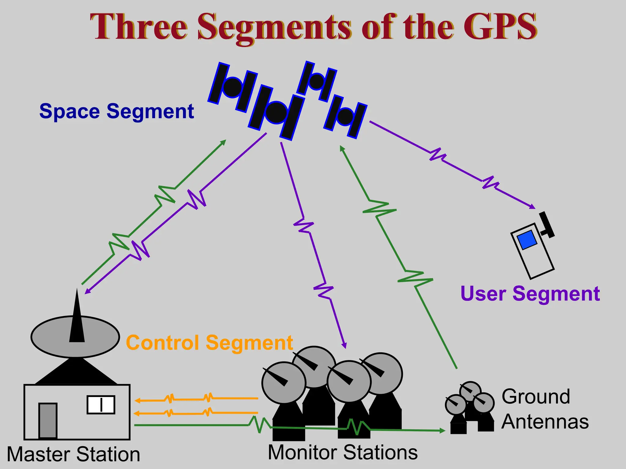
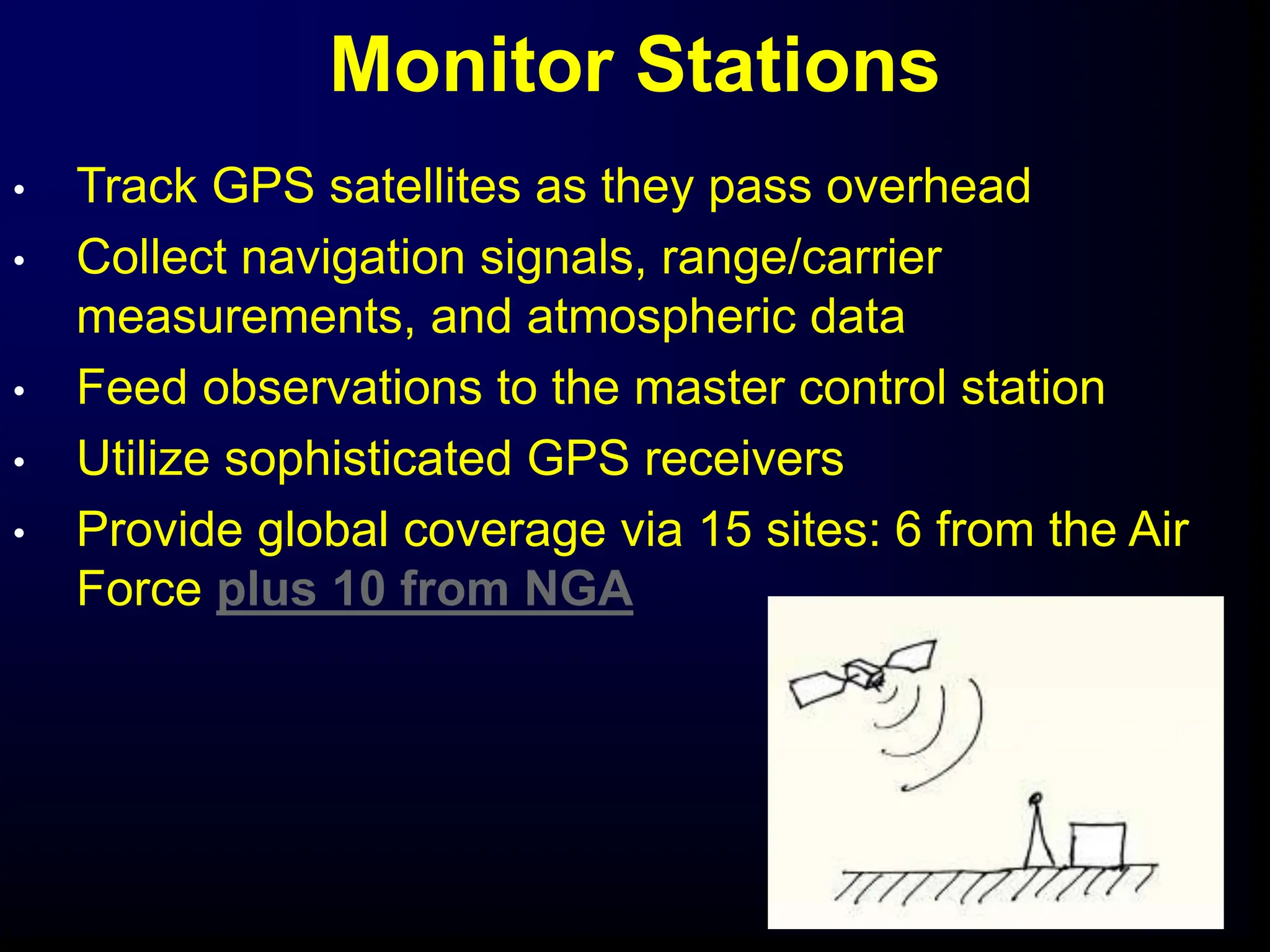
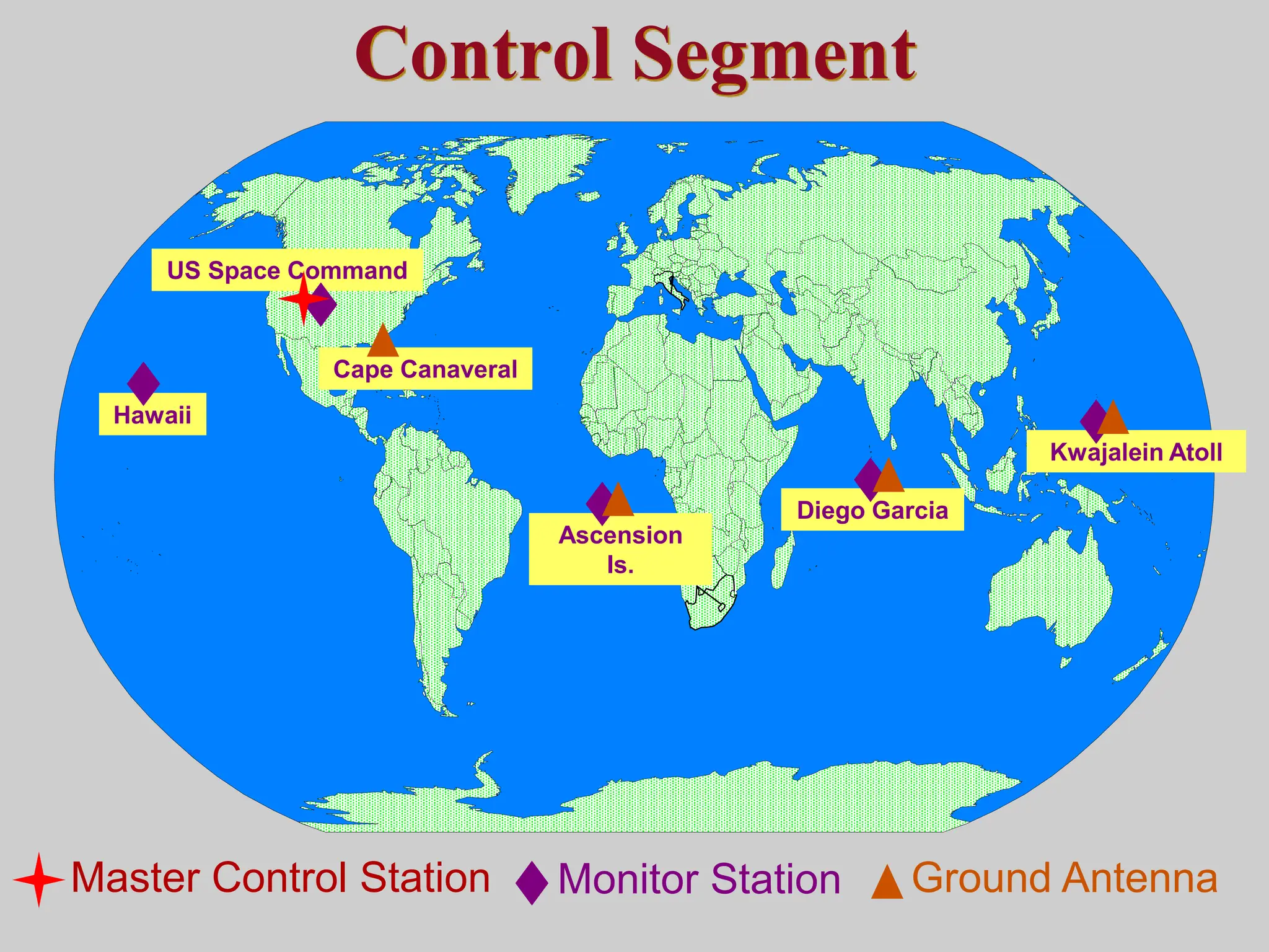
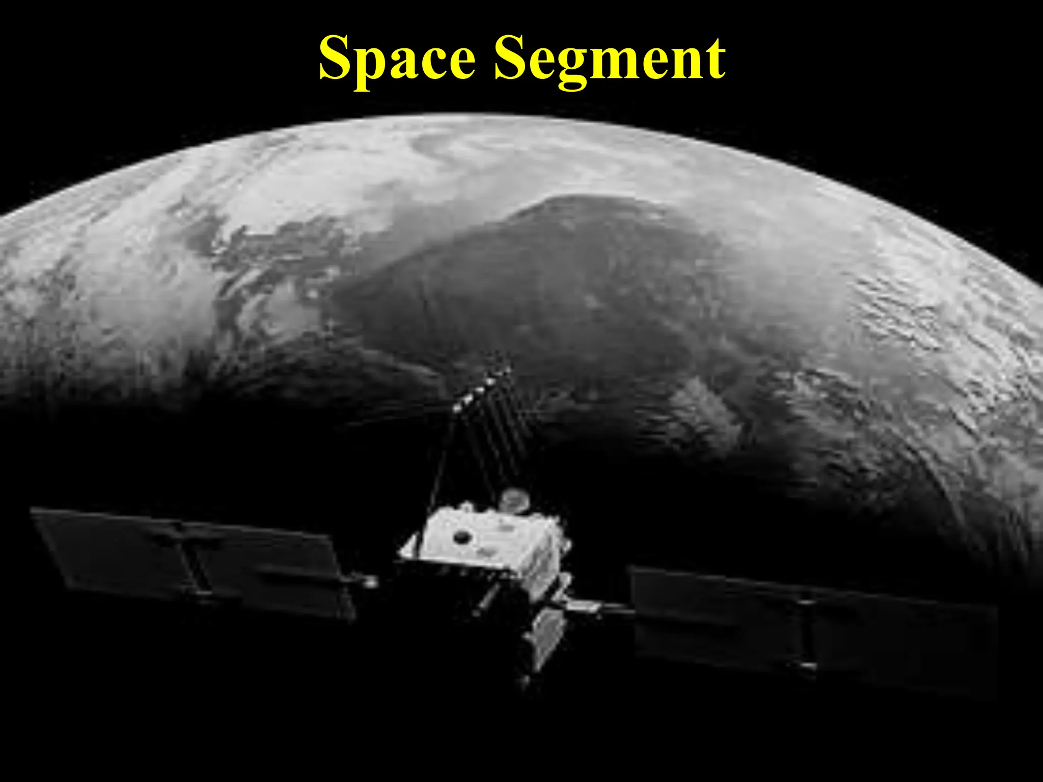
Introduction
to
NAVSTAR GPS
Charlie Leonard, 1999
(revised 2001, 2002)
 Feasibility studies begun in 1960’s.
 Pentagon appropriates funding in 1973.
 First satellite launched in 1978.
 System declared fully operational in April, 1995.
The History of GPS
How GPS Works
Control Segment
Space Segment
User Segment
Three Segments of the GPS
Monitor Stations
Ground
Antennas
Master Station
Monitor Stations
• Track GPS satellites as they pass overhead
• Collect navigation signals, range/carrier
measurements, and atmospheric data
• Feed observations to the master control station
• Utilize sophisticated GPS receivers
• Provide global coverage via 15 sites: 6 from the Air
Force plus 10 from NGA
Master control station
• Provides command and control of the GPS constellation
• Uses global monitor station data to compute the precise locations of
the satellites
• Generates navigation messages for upload to the satellites
• Monitors satellite broadcasts and system integrity to ensure
constellation health and accuracy
• Performs satellite maintenance and anomaly resolution, including
repositioning satellites to maintain optimal constellation
• Backed up by a fully operational alternate master control station
Kwajalein Atoll
US Space Command
Control Segment
Hawaii
Ascension
Is.
Diego Garcia
Cape Canaveral
Ground Antenna
Master Control Station Monitor Station
Space Segment
 Military.
 Search and rescue.
 Disaster relief.
 Surveying.
 Marine, aeronautical and terrestrial navigation.
 Remote controlled vehicle and robot guidance.
 Satellite positioning and tracking.
 Shipping.
 Geographic Information Systems (GIS).
 Recreation.
User Segment
 Position and coordinates.
 The distance and direction between any two waypoints, or a
position and a waypoint.
 Travel progress reports.
 Accurate time measurement.
Four Basic Functions of GPS
Position is Based on Time
T + 3
Distance between satellite
and receiver = “3 times the
speed of light”
T
Signal leaves satellite
at time “T”
Signal is picked up by the
receiver at time “T + 3”
Pseudo Random Noise Code
Receiver PRN
Satellite PRN
Time
Difference
What Time is It?
Zulu Time
Military Time
(local time on a 24 hour clock)
Universal Coordinated Time
Greenwich Mean Time
Local Time: AM and PM (adjusted for local
time zone)
GPS Time + 13*
* GPS Time is ahead of UTC by approximately 13 seconds
Signal From One Satellite
The receiver is
somewhere on
this sphere.
Signals From Two Satellites
Three Satellites (2D Positioning)
Triangulating Correct Position
Three Dimensional (3D) Positioning
Selective Availability (S/A)
 The Defense Department dithered the satellite time
message, reducing position accuracy to some GPS users.
 S/A was designed to prevent America’s enemies from using
GPS against us and our allies.
 In May 2000 the Pentagon reduced S/A to zero meters error.
 S/A could be reactivated at any time by the Pentagon.
Sources of GPS Error
Standard Positioning Service (SPS ): Civilian Users
Source Amount of Error
 Satellite clocks: 1.5 to 3.6 meters
 Orbital errors: < 1 meter
 Ionosphere: 5.0 to 7.0 meters
 Troposphere: 0.5 to 0.7 meters
 Receiver noise: 0.3 to 1.5 meters
 Multipath: 0.6 to 1.2 meters
 Selective Availability (see notes)
 User error: Up to a kilometer or more
Errors are cumulative and increased by PDOP.
Receiver Errors are Cumulative!
User error = +- 1 km
System and other flaws = < 9 meters
Sources of Signal Interference
Earth’s Atmosphere
Solid Structures
Metal Electro-magnetic Fields
Using GPS Receivers for
Positioning and Navigation
N (0000)
(00)
N
Desired Track
(DTK) (xº)
Present
Location
Tracking (TRK) (xº)
Active GOTO
Waypoint
GPS Navigation Terminology
Course Made Good (CMG)
(CMG) (xº)
Active
From
Waypoint
Active GOTO
Waypoint
Bearing =
Course Over Ground (COG) =
Cross Track Error (XTE) =
Location Where GOTO
Was Executed
Bearing = 650
COG = 50
XTE = 1/2 mi.
Bearing = 780
COG = 3500
XTE = 1/3 mi.
Bearing = 400
COG = 1040
XTE = 1/4 mi.
N
GPS Navigation: On the Ground
Position Fix
 A position is based on real-time satellite tracking.
 It’s defined by a set of coordinates.
 It has no name.
 A position represents only an approximation of the
receiver’s true location.
 A position is not static. It changes constantly as the GPS
receiver moves (or wanders due to random errors).
 A receiver must be in 2D or 3D mode (at least 3 or 4
satellites acquired) in order to provide a position fix.
 3D mode dramatically improves position accuracy.
Waypoint
 A waypoint is based on coordinates entered into a GPS
receiver’s memory.
 It can be either a saved position fix, or user entered
coordinates.
 It can be created for any remote point on earth.
 It must have a receiver designated code or number, or a user
supplied name.
 Once entered and saved, a waypoint remains unchanged in
the receiver’s memory until edited or deleted.
Planning a Navigation Route
Start
= Waypoint
How A Receiver Sees Your Route
GPS Waypoint Circle of Error
X
GPS Dilution of Precision and Its
Affects On GPS Accuracy
GPS Satellite Geometry
 Satellite geometry can affect the quality of GPS signals and accuracy
of receiver trilateration.
 Dilution of Precision (DOP) reflects each satellite’s position relative
to the other satellites being accessed by a receiver.
 There are five distinct kinds of DOP.
 Position Dilution of Precision (PDOP) is the DOP value used most
commonly in GPS to determine the quality of a receiver’s position.
 It’s usually up to the GPS receiver to pick satellites which provide the
best position triangulation.
 Some GPS receivers allow DOP to be manipulated by the user.
Ideal Satellite Geometry
N
S
W E
Good Satellite Geometry
Poor Satellite Geometry
N
S
W E
Poor Satellite Geometry
Differential GPS
DGPS Site
x+30, y+60
x+5, y-3
True coordinates =
x+0, y+0
Correction = x-5, y+3
DGPS correction = x+(30-5) and
y+(60+3)
True coordinates = x+25, y+63
x-5, y+3
Real Time Differential GPS
DGPS Receiver
Receiver
NDGPS Ground Stations
National Differential Global Positioning System
Yellow areas show overlap between NDGPS stations. Green areas are little to no coverage.
Topography may also limit some areas of coverage depicted here.
NDGPS Ground Stations
National Differential Global Positioning System
Yellow areas show overlap between NDGPS stations. Green areas are little to no coverage.
Topography may also limit some areas of coverage depicted here.
Wide Area Augmentation System
Geostationary
WAAS satellites
GPS Constellation
WAAS Control
Station (West Coast)
Local Area System (LAAS)
WAAS Control
Station (East
Coast)
How good is WAAS?
+ -
3 meters
+-15 meters
With Selective Availability set
to zero, and under ideal
conditions, a GPS receiver
without WAAS can achieve
fifteen meter accuracy most
of the time.*
Under ideal conditions a
WAAS equipped GPS
receiver can achieve three
meter accuracy 95% of the
time.*
* Precision depends on good satellite geometry, open sky view, and no user
induced errors.

How_GPS_Works_GNSS_Introduction to NAVSTAR GPS.ppt

  • 1.
  • 2.
     Feasibility studiesbegun in 1960’s.  Pentagon appropriates funding in 1973.  First satellite launched in 1978.  System declared fully operational in April, 1995. The History of GPS
  • 3.
  • 4.
    Control Segment Space Segment UserSegment Three Segments of the GPS Monitor Stations Ground Antennas Master Station
  • 5.
    Monitor Stations • TrackGPS satellites as they pass overhead • Collect navigation signals, range/carrier measurements, and atmospheric data • Feed observations to the master control station • Utilize sophisticated GPS receivers • Provide global coverage via 15 sites: 6 from the Air Force plus 10 from NGA
  • 6.
    Master control station •Provides command and control of the GPS constellation • Uses global monitor station data to compute the precise locations of the satellites • Generates navigation messages for upload to the satellites • Monitors satellite broadcasts and system integrity to ensure constellation health and accuracy • Performs satellite maintenance and anomaly resolution, including repositioning satellites to maintain optimal constellation • Backed up by a fully operational alternate master control station
  • 7.
    Kwajalein Atoll US SpaceCommand Control Segment Hawaii Ascension Is. Diego Garcia Cape Canaveral Ground Antenna Master Control Station Monitor Station
  • 8.
  • 9.
     Military.  Searchand rescue.  Disaster relief.  Surveying.  Marine, aeronautical and terrestrial navigation.  Remote controlled vehicle and robot guidance.  Satellite positioning and tracking.  Shipping.  Geographic Information Systems (GIS).  Recreation. User Segment
  • 10.
     Position andcoordinates.  The distance and direction between any two waypoints, or a position and a waypoint.  Travel progress reports.  Accurate time measurement. Four Basic Functions of GPS
  • 11.
    Position is Basedon Time T + 3 Distance between satellite and receiver = “3 times the speed of light” T Signal leaves satellite at time “T” Signal is picked up by the receiver at time “T + 3”
  • 12.
    Pseudo Random NoiseCode Receiver PRN Satellite PRN Time Difference
  • 13.
    What Time isIt? Zulu Time Military Time (local time on a 24 hour clock) Universal Coordinated Time Greenwich Mean Time Local Time: AM and PM (adjusted for local time zone) GPS Time + 13* * GPS Time is ahead of UTC by approximately 13 seconds
  • 14.
    Signal From OneSatellite The receiver is somewhere on this sphere.
  • 15.
    Signals From TwoSatellites
  • 16.
  • 17.
  • 18.
  • 19.
    Selective Availability (S/A) The Defense Department dithered the satellite time message, reducing position accuracy to some GPS users.  S/A was designed to prevent America’s enemies from using GPS against us and our allies.  In May 2000 the Pentagon reduced S/A to zero meters error.  S/A could be reactivated at any time by the Pentagon.
  • 20.
    Sources of GPSError Standard Positioning Service (SPS ): Civilian Users Source Amount of Error  Satellite clocks: 1.5 to 3.6 meters  Orbital errors: < 1 meter  Ionosphere: 5.0 to 7.0 meters  Troposphere: 0.5 to 0.7 meters  Receiver noise: 0.3 to 1.5 meters  Multipath: 0.6 to 1.2 meters  Selective Availability (see notes)  User error: Up to a kilometer or more Errors are cumulative and increased by PDOP.
  • 21.
    Receiver Errors areCumulative! User error = +- 1 km System and other flaws = < 9 meters
  • 22.
    Sources of SignalInterference Earth’s Atmosphere Solid Structures Metal Electro-magnetic Fields
  • 23.
    Using GPS Receiversfor Positioning and Navigation
  • 24.
    N (0000) (00) N Desired Track (DTK)(xº) Present Location Tracking (TRK) (xº) Active GOTO Waypoint GPS Navigation Terminology Course Made Good (CMG) (CMG) (xº) Active From Waypoint
  • 25.
    Active GOTO Waypoint Bearing = CourseOver Ground (COG) = Cross Track Error (XTE) = Location Where GOTO Was Executed Bearing = 650 COG = 50 XTE = 1/2 mi. Bearing = 780 COG = 3500 XTE = 1/3 mi. Bearing = 400 COG = 1040 XTE = 1/4 mi. N GPS Navigation: On the Ground
  • 26.
    Position Fix  Aposition is based on real-time satellite tracking.  It’s defined by a set of coordinates.  It has no name.  A position represents only an approximation of the receiver’s true location.  A position is not static. It changes constantly as the GPS receiver moves (or wanders due to random errors).  A receiver must be in 2D or 3D mode (at least 3 or 4 satellites acquired) in order to provide a position fix.  3D mode dramatically improves position accuracy.
  • 27.
    Waypoint  A waypointis based on coordinates entered into a GPS receiver’s memory.  It can be either a saved position fix, or user entered coordinates.  It can be created for any remote point on earth.  It must have a receiver designated code or number, or a user supplied name.  Once entered and saved, a waypoint remains unchanged in the receiver’s memory until edited or deleted.
  • 28.
    Planning a NavigationRoute Start = Waypoint
  • 29.
    How A ReceiverSees Your Route
  • 30.
  • 31.
    GPS Dilution ofPrecision and Its Affects On GPS Accuracy
  • 32.
    GPS Satellite Geometry Satellite geometry can affect the quality of GPS signals and accuracy of receiver trilateration.  Dilution of Precision (DOP) reflects each satellite’s position relative to the other satellites being accessed by a receiver.  There are five distinct kinds of DOP.  Position Dilution of Precision (PDOP) is the DOP value used most commonly in GPS to determine the quality of a receiver’s position.  It’s usually up to the GPS receiver to pick satellites which provide the best position triangulation.  Some GPS receivers allow DOP to be manipulated by the user.
  • 33.
  • 34.
  • 35.
  • 36.
  • 37.
  • 38.
  • 39.
  • 40.
    DGPS Site x+30, y+60 x+5,y-3 True coordinates = x+0, y+0 Correction = x-5, y+3 DGPS correction = x+(30-5) and y+(60+3) True coordinates = x+25, y+63 x-5, y+3 Real Time Differential GPS DGPS Receiver Receiver
  • 41.
    NDGPS Ground Stations NationalDifferential Global Positioning System Yellow areas show overlap between NDGPS stations. Green areas are little to no coverage. Topography may also limit some areas of coverage depicted here.
  • 42.
    NDGPS Ground Stations NationalDifferential Global Positioning System Yellow areas show overlap between NDGPS stations. Green areas are little to no coverage. Topography may also limit some areas of coverage depicted here.
  • 43.
    Wide Area AugmentationSystem Geostationary WAAS satellites GPS Constellation WAAS Control Station (West Coast) Local Area System (LAAS) WAAS Control Station (East Coast)
  • 44.
    How good isWAAS? + - 3 meters +-15 meters With Selective Availability set to zero, and under ideal conditions, a GPS receiver without WAAS can achieve fifteen meter accuracy most of the time.* Under ideal conditions a WAAS equipped GPS receiver can achieve three meter accuracy 95% of the time.* * Precision depends on good satellite geometry, open sky view, and no user induced errors.

Editor's Notes

  • #7 Baked up : soutenu par