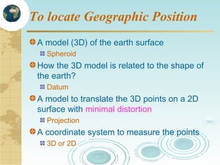
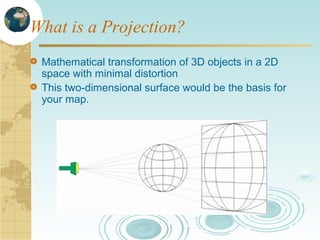
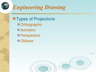
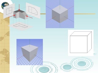
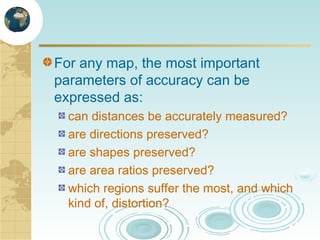
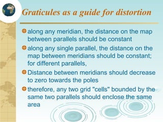
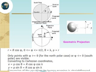
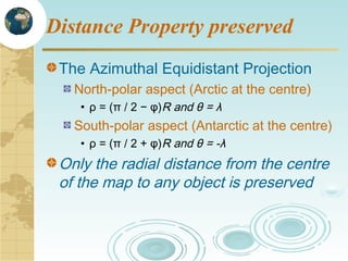
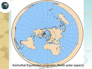
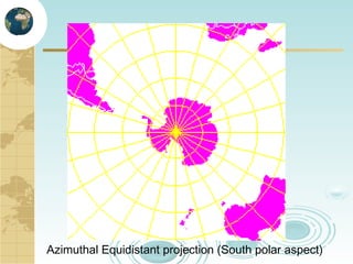
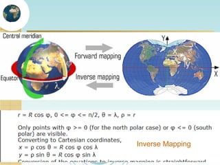
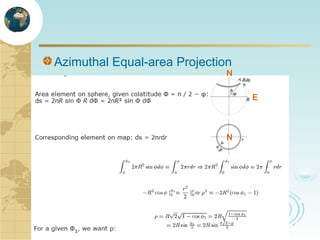
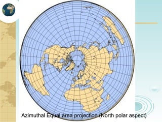
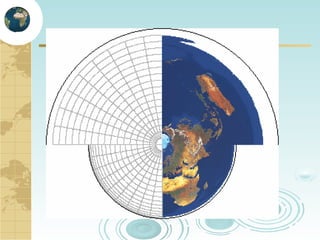
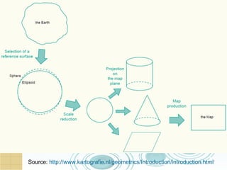
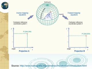
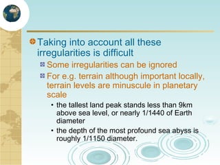
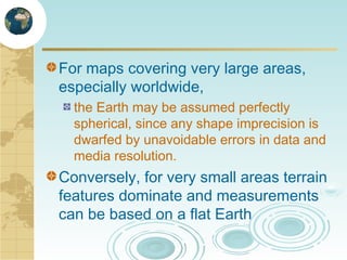
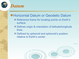
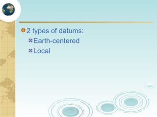
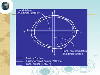
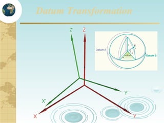
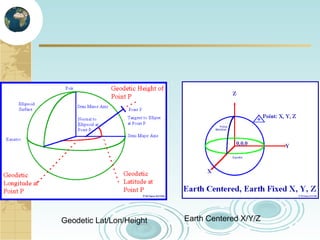
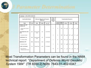
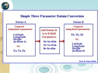
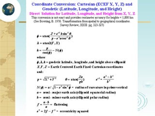
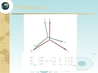
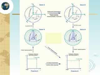
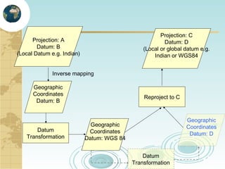
Mathematical Principles
behind Projections
To locate Geographic Position
A model (3D) of the earth surface
Spheroid

How the 3D model is related to the shape of
the earth?
Datum

A model to translate the 3D points on a 2D
surface with minimal distortion
Projection

A coordinate system to measure the points
3D or 2D
What is a Projection?
Mathematical transformation of 3D objects in a 2D
space with minimal distortion
This two-dimensional surface would be the basis for
your map.
Engineering Drawing
Types of Projections
Orthographic
Isometric
Perspective
Oblique
For any map, the most important
parameters of accuracy can be
expressed as:
can distances be accurately measured?
are directions preserved?
are shapes preserved?
are area ratios preserved?
which regions suffer the most, and which
kind of, distortion?
Although all properties cannot be preserved,
a reasonably small spherical patch can be
approximated by a flat sheet with acceptable
distortion
In most projections, at least one specific
region (usually the center of the map) suffers
little or no distortion.
If the represented region is small enough , the
projection choice may be of little importance.
Geometric Projection
geometric interpretation as light rays
projected from a source intercept the
Earth and, according to laws of
perspective, "draw" its features on a
surface (Plane, cylinder, or cone)

Algorithmic Projection
are described purely by mathematical
formulae
• E.g. equal-distant, equal area etc.,
Graticule
Graticules as a guide for distortion
along any meridian, the distance on the map
between parallels should be constant
along any single parallel, the distance on the
map between meridians should be constant;
for different parallels,
Distance between meridians should decrease
to zero towards the poles
therefore, any two grid "cells" bounded by the
same two parallels should enclose the same
area
Geometric Projection
Distance Property preserved
The Azimuthal Equidistant Projection
North-polar aspect (Arctic at the centre)
• ρ = (π / 2 − φ)R and θ = λ

South-polar aspect (Antarctic at the centre)
• ρ = (π / 2 + φ)R and θ = -λ

Only the radial distance from the centre
of the map to any object is preserved
Azimuthal Equidistant projection (North polar aspect)
Azimuthal Equidistant projection (South polar aspect)
Inverse Mapping
Azimuthal Equal-area Projection

N
E

N
Azimuthal Equal area projection (North polar aspect)
Self-Study
http://www.progonos.com/furuti/index.html
http://mathworld.wolfram.com/MapProjection.html
http://mathworld.wolfram.com/Ellipse.html
http://mathworld.wolfram.com/Ellipsoid.html
Assignment
Map Projection
• Derive equations for azimuthal equal-distance and equal area
from the equatorial aspect

Reference:
• http://www.progonos.com/furuti/index.html
• Books:
– Engineering Surveying, Higher Surveying
One projection to another
Source: http://www.kartografie.nl/geometrics/Introduction/introduction.html
Datum Transformation
Earth is not a sphere
Earth mass is not distributed uniformly, so
the gravitational pull is not uniform
Due to rotation, equator is slightly bulged,
and poles are slightly flattened (1/300)
• Oblate Spheroid

Terrain is not uniform
Highest spot on earth?
What is the tallest peak on earth?
Mount Everest, at 8,850 meters above
MSL

What is the highest spot on earth where
you are the closest to the outer space?
Mount Chimborazo, in the Andes,
• 6,100 meters above MSL
• But is sitting on a bulge which makes it 2,400
meters taller than Everest
• Everest is sitting down on the lower side of the
same bulge

Source: http://www.npr.org/templates/story/story.php?storyId=9428163
Deviations (undulations) between the
Geoid and the WGS84 ellipsoid

Source: http://www.kartografie.nl/geometrics/Introduction/introduction.html
Earth Surfaces
Sea surface

Geoid

Ellipsoid

Topographic
surface
Geoid is a surface of constant gravity.
Taking into account all these
irregularities is difficult

Some irregularities can be ignored
For e.g. terrain although important locally,
terrain levels are minuscule in planetary
scale
• the tallest land peak stands less than 9km
above sea level, or nearly 1/1440 of Earth
diameter
• the depth of the most profound sea abyss is
roughly 1/1150 diameter.
For maps covering very large areas,
especially worldwide,
the Earth may be assumed perfectly
spherical, since any shape imprecision is
dwarfed by unavoidable errors in data and
media resolution.

Conversely, for very small areas terrain
features dominate and measurements
can be based on a flat Earth
Datum
Horizontal Datum or Geodetic Datum
Reference frame for locating points on Earth’s
surface.
Defines origin & orientation of latitude/longitude
lines.
Defined by spheroid and spheroid’s position
relative to Earth’s center.
2 types of datums:
Earth-centered
Local
Local datum
coordinate system

Earth-centered datum
coordinate system
Earth’s S urface
Earth-centered datum (WGS84)
Local datum (NAD27)
Datum Transformation
Cartesian Coordinate System
WGS -84 is
Earth Centered
Earth Fixed;
Origin to with
+/- 10 cm

Z

Ellipsoid
sized a & f

Y

X
Datums and Defining
Parameters
To translate one datum to another we must know the
relationship between the chosen ellipsoids in terms of
position and orientation. The relationship is defined by 7
constants.
A. 3 - Distance of the ellipsoid center from the center of the
earth (∆X, ∆Y, ∆Z)
B. 3 - Rotations around the X, Y, and Z of the Cartesian
Coordinate System Axes (ε, ψ, ω)
C. 1 - Scale change (S) of the survey control network

2 - The size and shape of the ellipsoid (semi major axis
a and flattening f approximately 1/298
Translations (3 Parameters)
Movement of points along an Axis

∆X

∆Y

∆Z
Rotations (3 Parameters)
Movement of points around an Axis

ε

ψ
ω
Scale (1 Parameter)
Changing the distance between points

S
Datum Transformation
Simple Three-parameter transformation
Geocentric translation

Seven-parameter transformation
Helmert 7-parameter transformation

Standard Molodensky formulas
Geodetic Lat/Lon/Height

Earth Centered X/Y/Z
3 Parameters

X’
Y’
Z’

=

X
Y
Z

∆X
+ ∆Y
∆Z
3 Parameter Determination

Most Transformation Parameters can be found in the NIMA
technical report “Department of Defense World Geodetic
System 1984” (TR 8350.2) NSN: 7643-01-402-0347
7 Parameters
Projection: C
Datum: D
(Local or global datum e.g.
Indian or WGS84

Projection: A
Datum: B
(Local Datum e.g. Indian)
Inverse mapping
Geographic
Coordinates
Datum: B

Datum
Transformation

Reproject to C

Geographic
Coordinates
Datum: D

Geographic
Coordinates
Datum: WGS 84
Datum
Transformation
Self-Study
http://www.progonos.com/furuti/MapProj/CartIndex/ca
rtIndex.html
http://mathworld.wolfram.com/Ellipse.html
http://mathworld.wolfram.com/Ellipsoid.html
References:
http://www.colorado.edu/geography/gcraft/notes/datum/datum.html
https://www.navigator.navy.mil/navigator/gis.htm
http://earth-info.nga.mil/GandG/coordsys/datums/index.html
http://www.kartografie.nl/geometrics/Introduction/introduction.html

7 8.math projection (2)

Editor's Notes

  • #35 The National Imagery and Mapping Agency (NIMA) and the Defense Mapping School Reviewed by:____________Date:_________ Reviewed by:____________Date:_________ Objective: Given an overview of the National Imagery and Mapping Agency and the Defense Mapping School, the student will understand the mission issues associated with Datums, Map Projections and Coordinates. Time: 1.5 hours Training Aids and Devices: Computer, Projector/LCD Panel, Screen, Pointer, Map Examples and a PracticalExercise. Student Material and Equipment: Mapping Charting & Geodesy for the Warrior Notes. Special Requirements: None Text References: Elements of Cartography by Robinson, Geodesy for the Layman, DMA TM 8358.1; DMA TR 8350.2; TEC-SR-7;
  • #37 Geodetic Datum - fixes the ellipsoid to the mean earth, basically we need to know the relationship between the chosen ellipsoid and the earth in terms of position and orientation. It is defined by 8 constants. 1. 2 - The size and shape of the ellipsoid (semi major axis and flattening) 2. 3 - The distances of the ellipsoid center from the center of the earth 3. 2 - The directions of the rotation axis with the mean rotation of the earth 4. 1 - The direction of 0 longitude with the earth’s international 0 longitude
  • #41 The parameters that define the differences between 2 datums are as follows: a. The differences in meters between the two ellipsoid centers called delta x, delta y, delta z b. The rotation about the Z axis is seconds of arc between the two ellipsoids 0 longitude c. The difference in size between the two ellipsoids d. The rotations in seconds of arc about the X and Y axis, the attitude of the spin axis