1. The Shape of the Earth
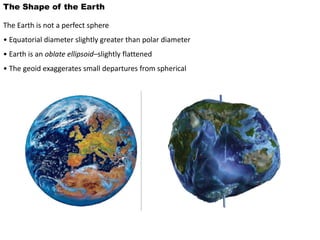
The Earth is not a perfect sphere
• Equatorial diameter slightly greater than polar diameter
• Earth is an oblate ellipsoid–slightly flattened
• The geoid exaggerates small departures from spherical
2.
3.
4. The Earth’s Rotation
Earth rotates on its axis:
•Counterclockwise at North Pole
•Left to right (eastward) at Equator
•One rotation is a solar day (24 hours)
Axis: an imaginary straight
line through the center of
the Earth around which
the Earth rotates
Poles: the two points on
the Earth’s surface where
the axis of rotation
emerges
6. The Geographic Grid
Parallels and Meridians
Geographic grid: network of parallels and meridians used to fix location on the
Earth
Parallel: east-west circle on the
Earth’s surface, lying on a plane
parallel to the equator
Meridian: north-south line on the
Earth’s surface, connecting the
poles
7.
8. The Geographic Grid
Parallels and Meridians
Equator: Parallel of latitude lying midway between the Earth’s poles; it is
designated latitude 0º
• Longest parallel of latitude
• Midway between poles
• Fundamental reference line for measuring position
Latitude: arc of a
meridian between the
equator and a given
point on the globe
Longitude: arc of a
parallel between the
prime meridian and
a given point on the
globe
9. The Geographic Grid
Latitude and Longitude
Latitude is measured north and
south of the equator, up to 90º
Longitude is measured east and west
of the Prime Meridian—meridian
that passes through Greenwich,
England—up to 180º
11. Earth’s Revolution Around the Sun
The Four Seasons
Earth’s axis tilted toward North Star throughout Earth’s orbit.
• December 22: N hemisphere tilted away from the sun at the maximum angle
• June 21: N hemisphere tilted toward the sun at the maximum angle
12. Earth’s Revolution Around the Sun
The Four Seasons
Summer solstice:
solstice occurring on
June 21 or 22, when
the subsolar point is
at 23 1/2° N; June
Solstice
Winter solstice: solstice
occurring on December
21 or 22, when the
subsolar point is at 23
1/2° S; December
Solstice
Equinox: time when subsolar
point falls on equator and
circle of illumination passes
through both poles
Circle of illumination: separates day
hemisphere from night hemisphere
13. Earth’s Revolution Around the Sun
Equinox Conditions
Subsolar point: point on the Earth’s surface where
the sun is directly overhead at noon
• Circle of illumination
passes through both poles
• Subsolar point at
equator
• Day and night of equal
length everywhere on the
globe
•Occurs twice per year
•Vernal Equinox:
March 21
•Autumnal Equinox:
September 23
14. Earth’s Revolution Around the Sun
Solstice Conditions
•Circle of illumination grazes Arctic and Antarctic Circles
•June Solstice: north pole has 24 hours of daylight; daylength increases from equator to north
pole
•December Solstice: south pole has 24 hours of daylight; daylength increases from equator to
south pole
15. Earth’s Revolution Around the Sun
Earth revolves around the sun every 365.242 days
• Orbit is an ellipse
• Leap year corrects for the extra quarter day
• Orbit is counterclockwise
• Perihelion: point in orbit when Earth is closest to Sun
• Aphelion: point in orbit when Earth is farthest from Sun
16.
17.
18. A great-circle arc, on the sphere, is the analogue
of a straight line, on the plane.
Where two such arcs intersect, we can define
the spherical angle either as angle between
the tangents to the two arcs, at the point of
intersection, or as the angle between the
planes of the two great circles where they
intersect at the centre of the sphere.
(Spherical angle is only defined where arcs of
great circles meet.)
19. A spherical triangle is made up of
three arcs of great circles, all less
than 180°.
The sum of the angles is not fixed,
but will always be greater than 180°.
If any side of the triangle is exactly
90°, the triangle is called quadrantal.
20. Set up a system of
rectangular axes OXYZ:
O is at the centre of the
sphere;
OZ passes through A;
OX passes through arc AB
(or the extension of it);
OY is perpendicular to both.
Find the coordinates of C in
this system:
x = sin(b) cos(A)
y = sin(b) sin(A)
z = cos(b)
25. Napier's Rules for a spherical right triangle
1. The sine of an angle is equal to the product of cosines
of the opposite two angles.
2. The sine of an angle is equal to the product of tangents
of the two adjacent angles.
26. Nautical Mile
It is the distance measured along
the great circle joining the points
which subtends one minute of arc
at the centre of earth
27. Exercise:
A point A, has longitude 2°W, latitude 50°N.
And another place B, has longitude 97°W,
latitude 50°N.
How far apart are they, in nautical miles, along a
great circle arc?
28. Use the cosine rule:
cos AW = cos WP cos AP + sin WP sin AP cos P
= cos240° + sin240° cos 95°
= 0.5508
So AW = 56.58°
= 3395 nautical miles
29. (This is 7% shorter than the route along a parallel of latitude).
If you set off from Alderney on a great-circle route to Winnipeg,
in what direction (towards what azimuth) would you head?
Use the sine rule:
sin A / sin WP = sin P / sin WA
so sin x = sin 40° sin 95° / sin 56.58° = 0.77
so x = 50.1° or 129.9° .
Common sense says 50.1° (or check using cosine rule to get PW).
Azimuth is measured clockwise from north,
so azimuth is 360° - 50.1° = 309.9°
(Note that this is 40° north of the “obvious” due-west course.)
Back to "Spherical trigonometry".
30.
31.
32.
33.
34.
35. (Figure 4-2). In the continental United States,
longitude is commonly reported as a west
longitude. To convert easterly to westerly
referenced longitudes, the easterly longitude
must be
subtracted from 360 deg.
36.
37. I. Latitude and Longitude on Spherical Earth
Latitude and longitude are the grid lines you
see on globes. For a spherical earth
these are angles seen from the center of the
earth. The angle up from the equator is
latitude. In the southern hemisphere is it
negative in the convention used in geodesy. It
has a range of –90 degrees to 90 degrees. The
reference for latitude is set by the equator -
effectively set by the spin axis of the earth.
The angle in the equatorial plane is the
longitude. There is no natural reference for
longitude. The zero line, called the prime
meridian, is taken, by convention, as the line
through Greenwich England. (This was set by
treaty in 1878. Before that each major
nation had its own zero of longitude.)
38.
39.
40. astronomical latitude,
φ. The point where the plumb-line’s direction meets the equatorial plane is not, in
general, the centre
of the Earth. The angle between the line joining the observer to the Earth’s centre and
the equatorial
plane is the geocentric latitude, φ (see figure 7.3).
There is yet a third definition of latitude. Geodetic measurements on the Earth’s surface
show
local irregularities in the direction of gravity due to variations in the density and shape
of the Earth’s
crust. The direction in which a plumb-line hangs is affected by such anomalies and these
are referred to
as station error. The geodetic or geographic latitude, φ, of the observer is the
astronomical latitude
corrected for station error.
The geodetic latitude is, therefore, related to a reference spheroid whose surface is
defined by the
mean ocean level of the Earth. If a and b are the semi-major and semi-minor axes of the
ellipse ofrevolution forming the ‘geoid’, the flattening or ellipticity, , is given by
41.
42.
43. The longitude used in geodesy is positive going
east from the prime meridian. The
values go from 0 to 360 degrees. A value in the
middle United States is therefore about
260 degrees east longitude. This is the same as
-100 degrees east.
In order to make longitudes more convenient,
often values in the western
hemisphere are quoted in terms of angles west
from the prime meridian. Thus the
2
longitude of -100 E (E for East) is also 100 W
(W for West). Similarly latitudes south of
the equator are often given as "S" (for south)
values to avoid negative numbers.
44.
45.
46. Latitude and Longitude on Ellipsoidal Earth
The earth is flattened by rotational effects. The
cross-section of a meridian is no
loner a circle, but an ellipse. The ellipse that
best fits the earth is only slightly different
from a circle. The flattening, defined in the
figure below, is about 1/298.25 for the earth.
Latitude and longitude are defined to be
"intuitively the same as for a spherical
earth". This loose definition has been made
precise in geodesy. The longitude is the
exactly the same as for a spherical earth. The
way latitude is handled was defined by the
French in the 17th century after Newton
deduced that the world had an elliptical
crosssection.
47. Before satellites latitude was measured by
observing the stars. In particular
observing the angle between the horizon and
stars. The horizon was taken to be
perpendicular to the vertical measured by a
plumb bob or spirit level. The "vertical line"
of the plumb bob was thought to be
perpendicular to the sphere that formed the
earth.
The extension to an ellipsoidal earth is to use
the line perpendicular to the ellipsoid to
define the vertical. This is essentially the same
as the plumb bob.1
48. The figures below show the key effects of
rotation on the earth and coordinates.
The latitude is defined in both the spherical
and ellipsoidal cases from the line
perpendicular to the world model. In the case
of the spherical earth, this line hits the
origin of the sphere - the center of the earth.
For the ellipsoidal model the up-down line
does not hit the center of the earth. It does hit
the polar axis though
49.
50.
51. The length of the line to the center of the
earth for a spherical model is the radius
of the sphere. For the ellipsoidal model the
length from the surface to the polar axis is
one of three radii needed to work with angles
and distance on the earth. (It is called the
radius of curvature in the prime vertical, and
denoted RN here. See the note on radii of the
earth for details.)
There are not two types of latitude that can
easily be defined. The angle that the
line makes from the center of the earth is
called the geocentric latitude. Geocentric
latitude is usually denoted as f¢, or fc . It is
commonly used in satellite work. It does not
strike the surface of the ellipsoid at a right
angle. The line perpendicular to the ellipsoid
makes an angle with the equatorial plane that
is called the geodetic latitude. (“Geodetic"
in geodesy usually implies something taken
with respect to the ellipsoid.) The latitude on
maps is geodetic latitude. It is usually denoted
as g
52.
53. Geodetic Coordinates.
Geodetic coordinate components consist of:
· latitude (f),
· longitude (l),
· ellipsoid height (h).
Geodetic latitude, longitude, and ellipsoid height
define the position of a point on the surface of the
Earth with respect to the reference ellipsoid.
54. 1) Geodetic latitude (f).
The geodetic latitude of a point is
the acute angular distance between
the equatorial plane and the normal
through the point on the ellipsoid
measured in the meridian plane
Geodetic latitude is positive north of the
equator and negative south of the equator.
55. (2) Geodetic longitude (l).
The geodetic longitude is the angle
measured counter-clockwise (east), in
the equatorial plane, starting from the
prime meridian (Greenwich meridian),
to the meridian of the defined point
56. (3) Ellipsoid Height (h).
The ellipsoid height is the linear distance above the
reference ellipsoid measured along the ellipsoidal
normal to the point in question.
The ellipsoid height is positive if the reference
ellipsoid is below the topographic surface and
negative if the ellipsoid is above the topographic
surface.