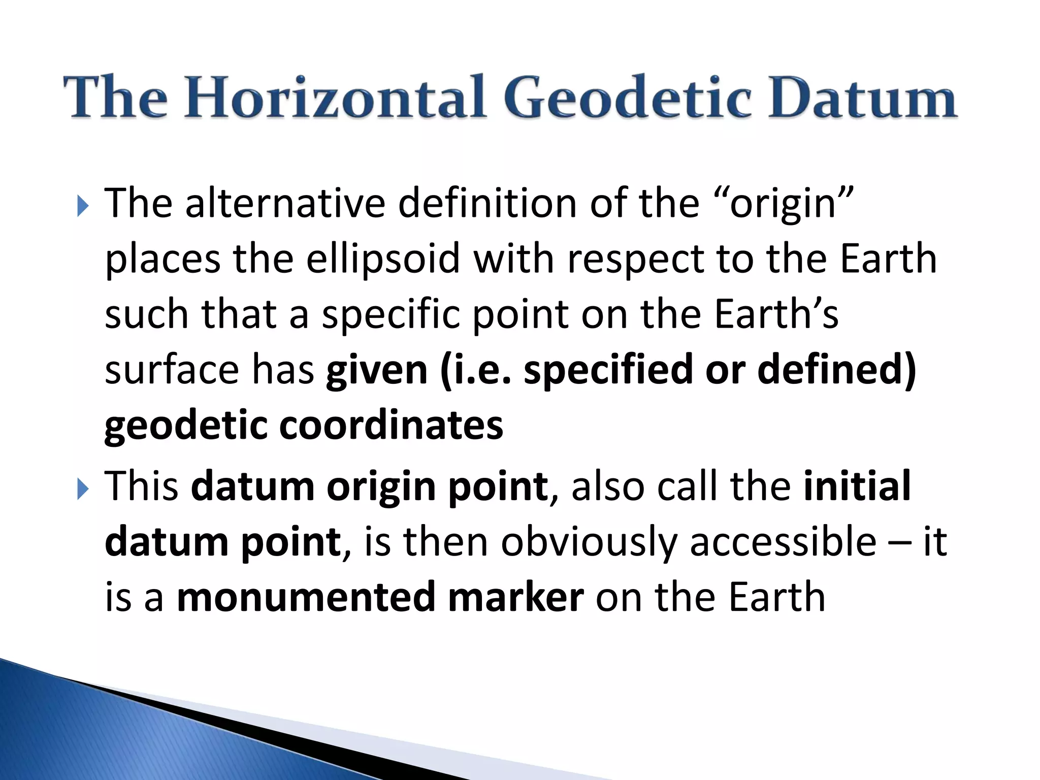
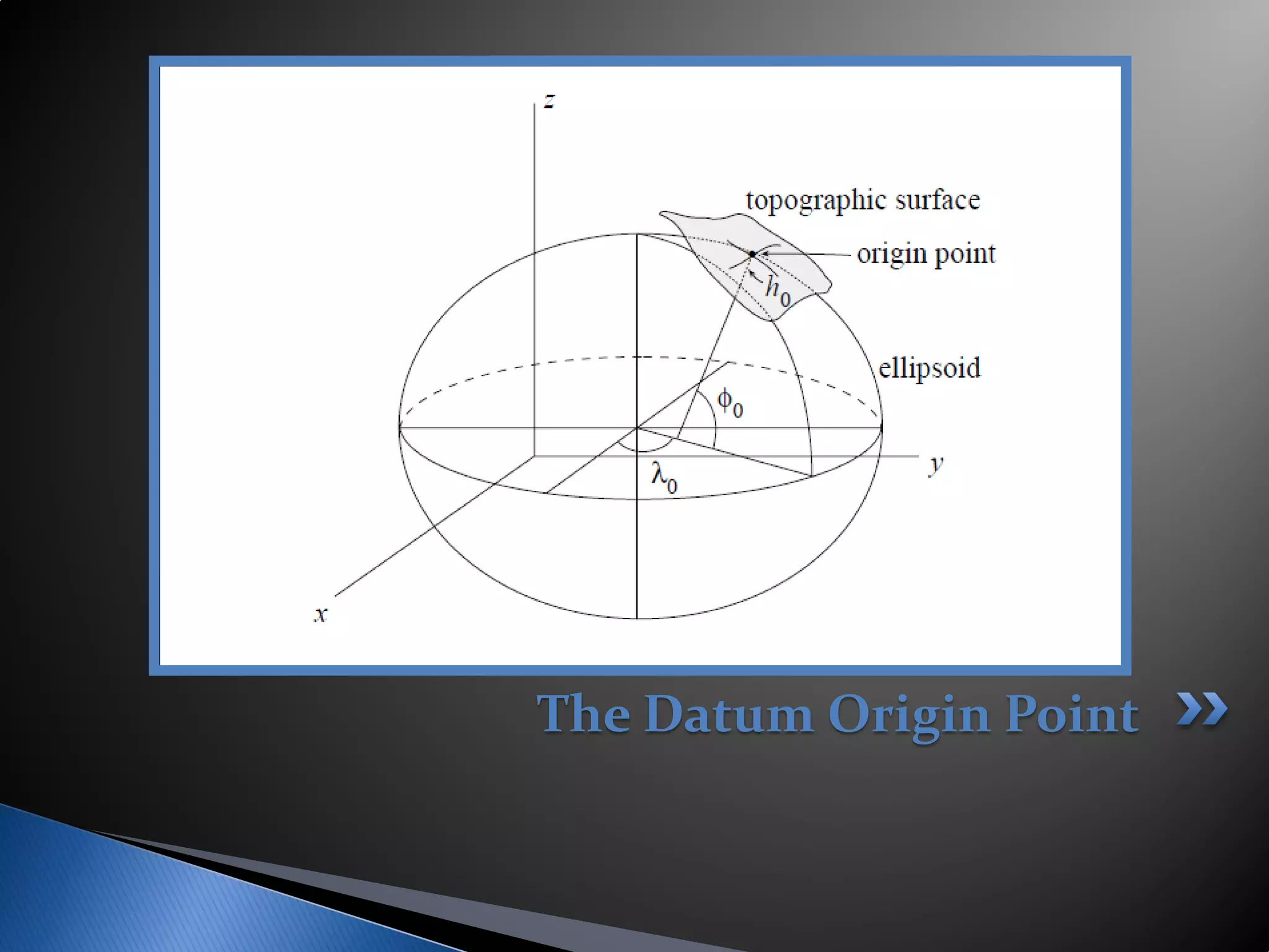
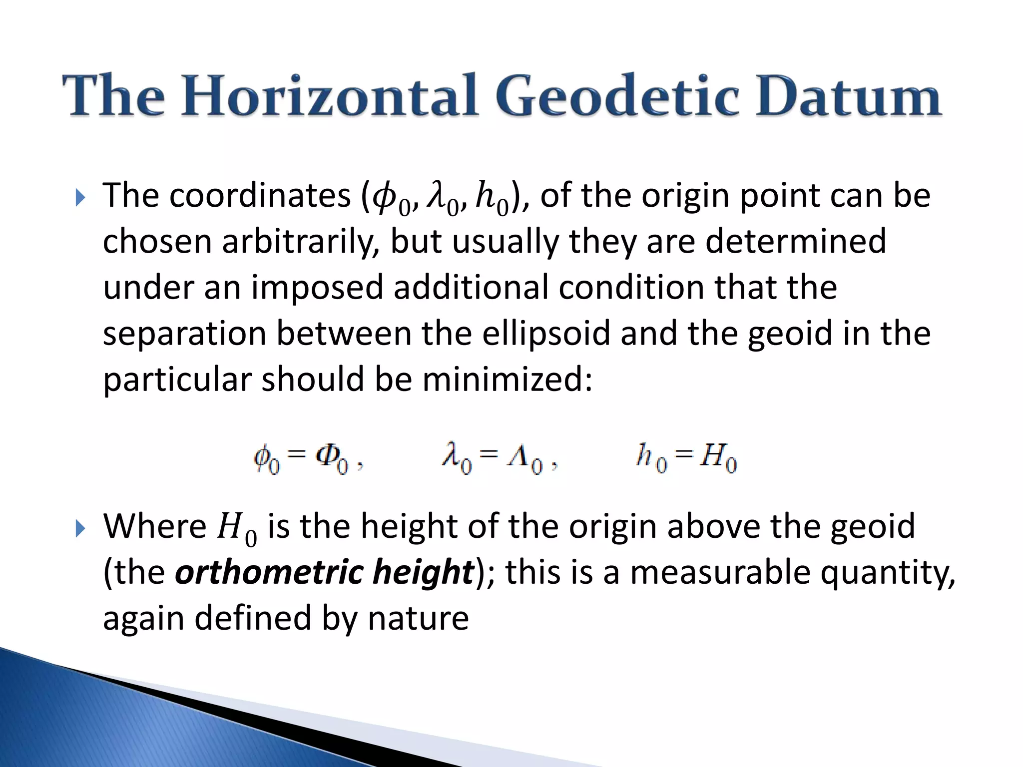
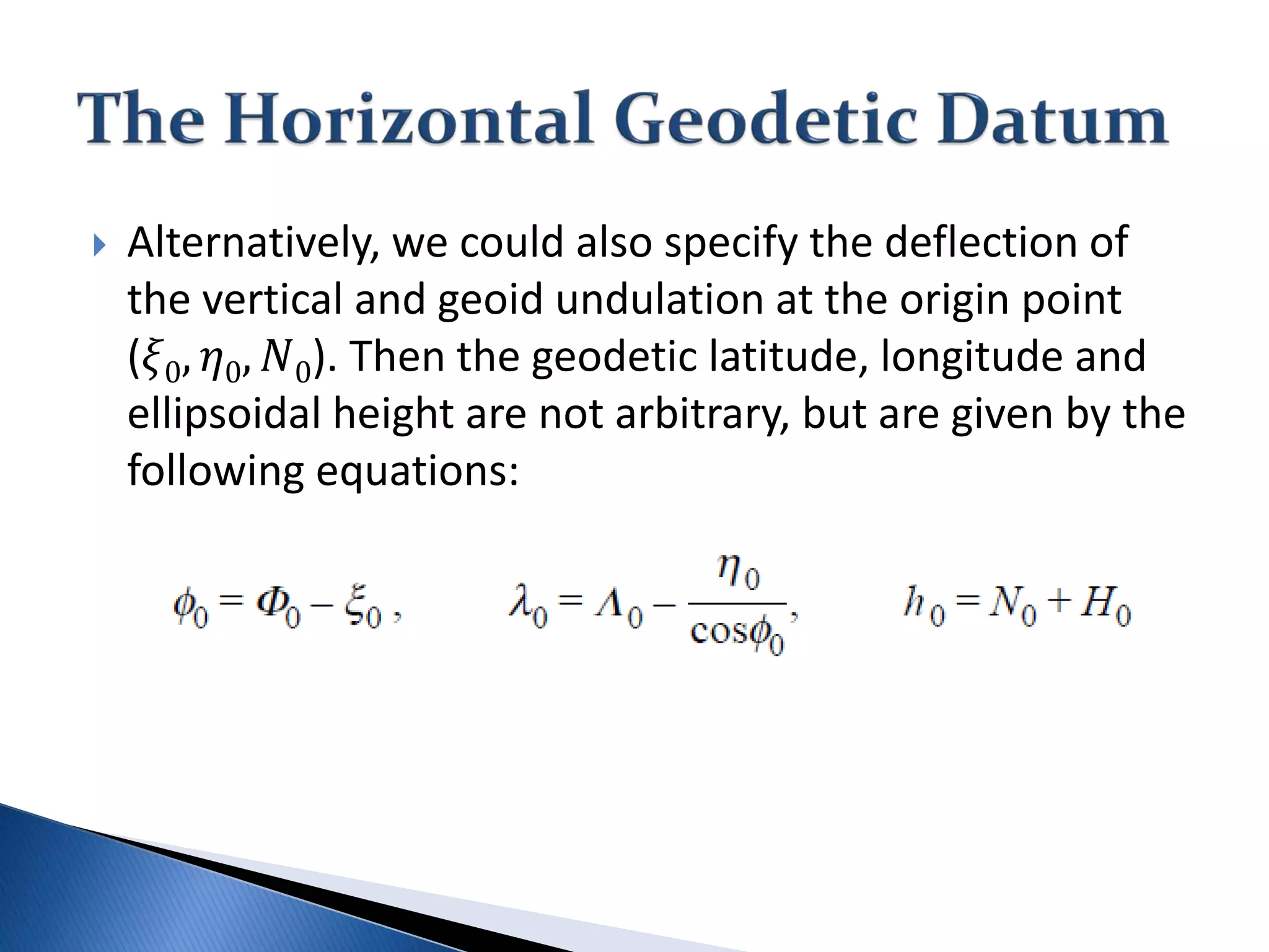
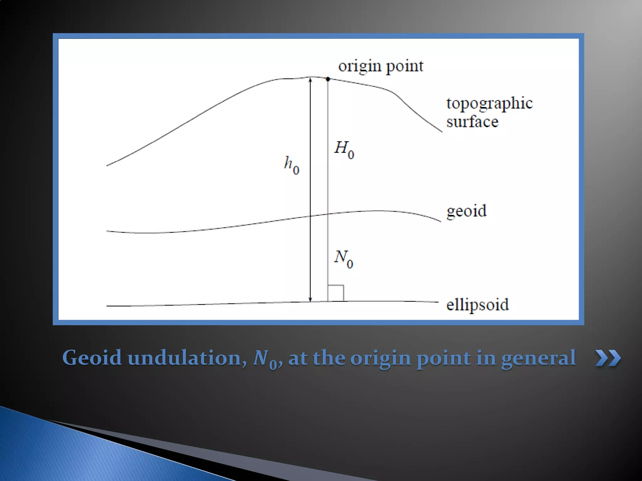
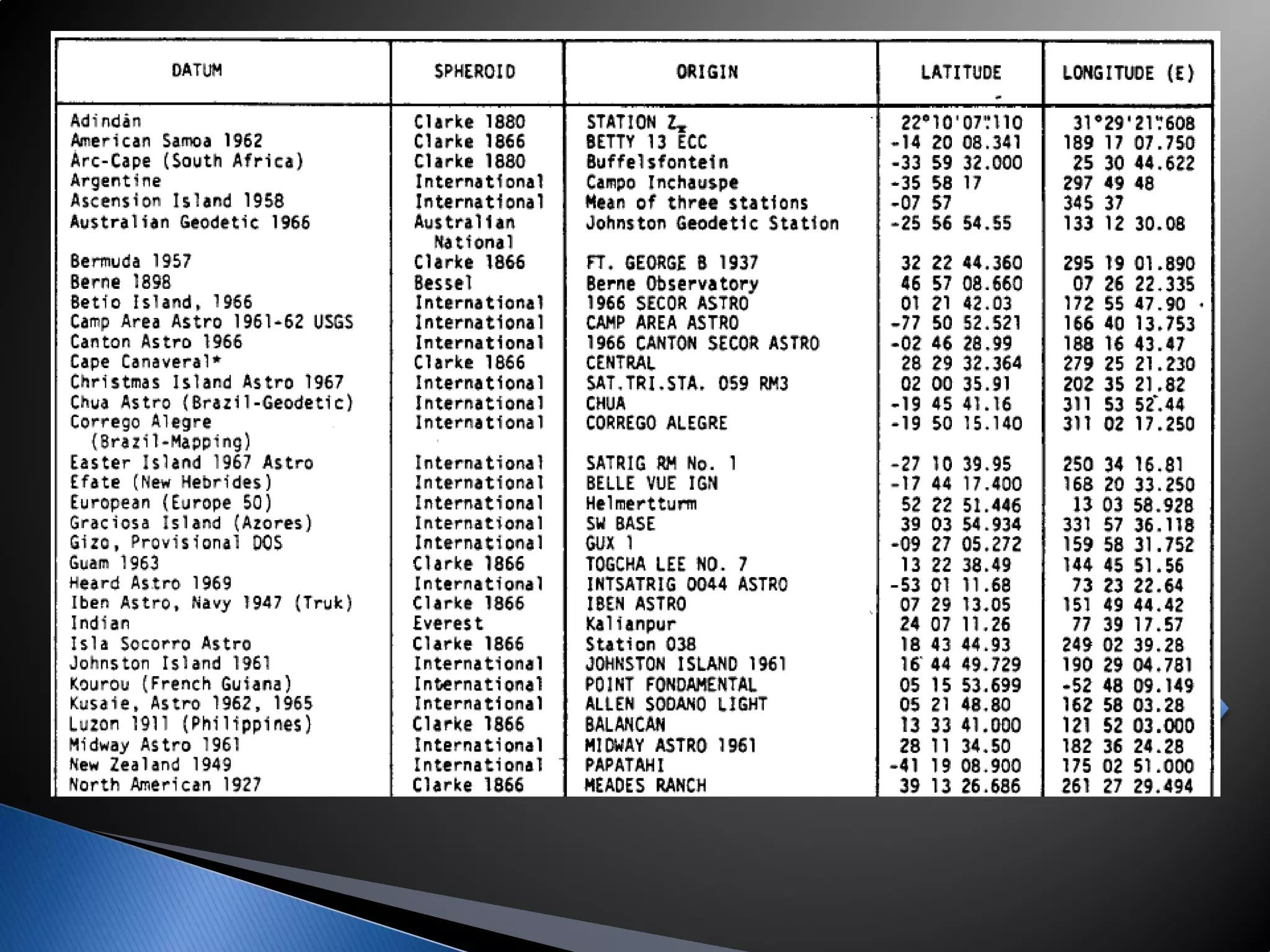
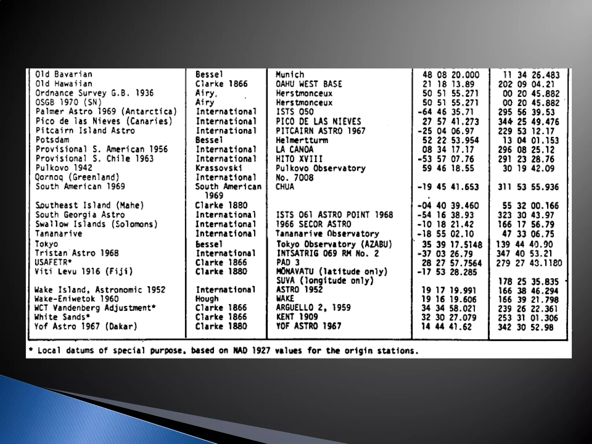
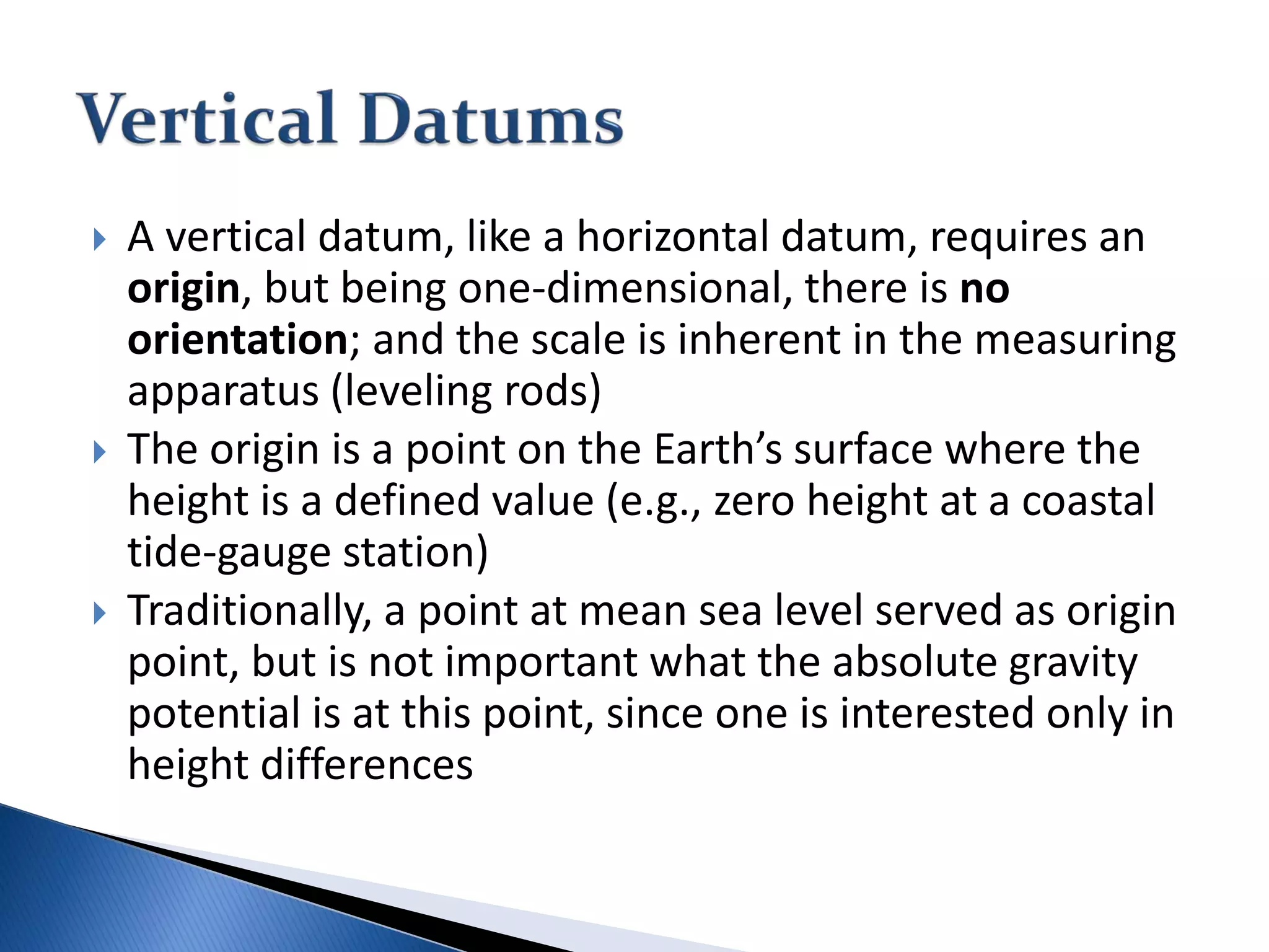
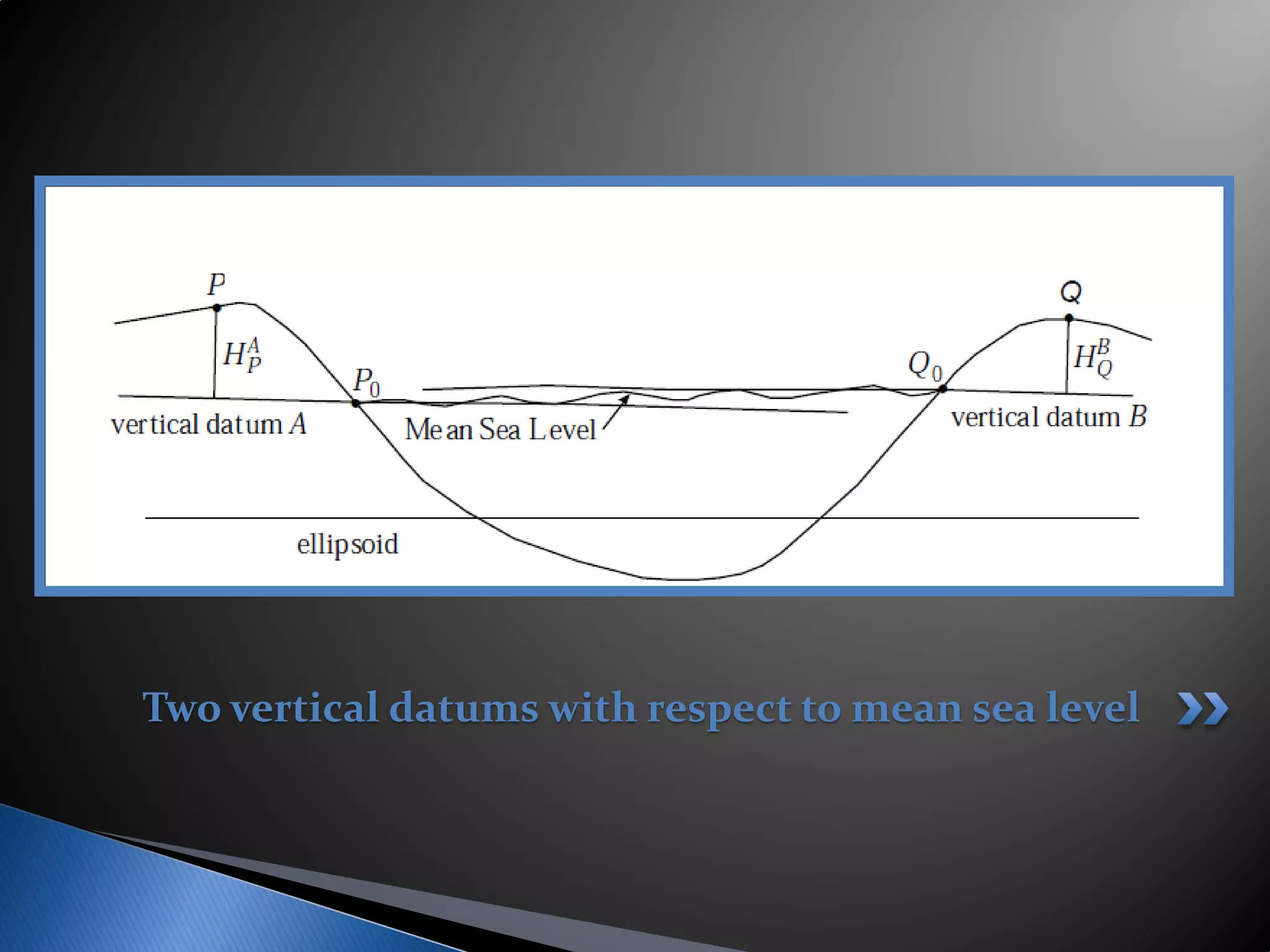
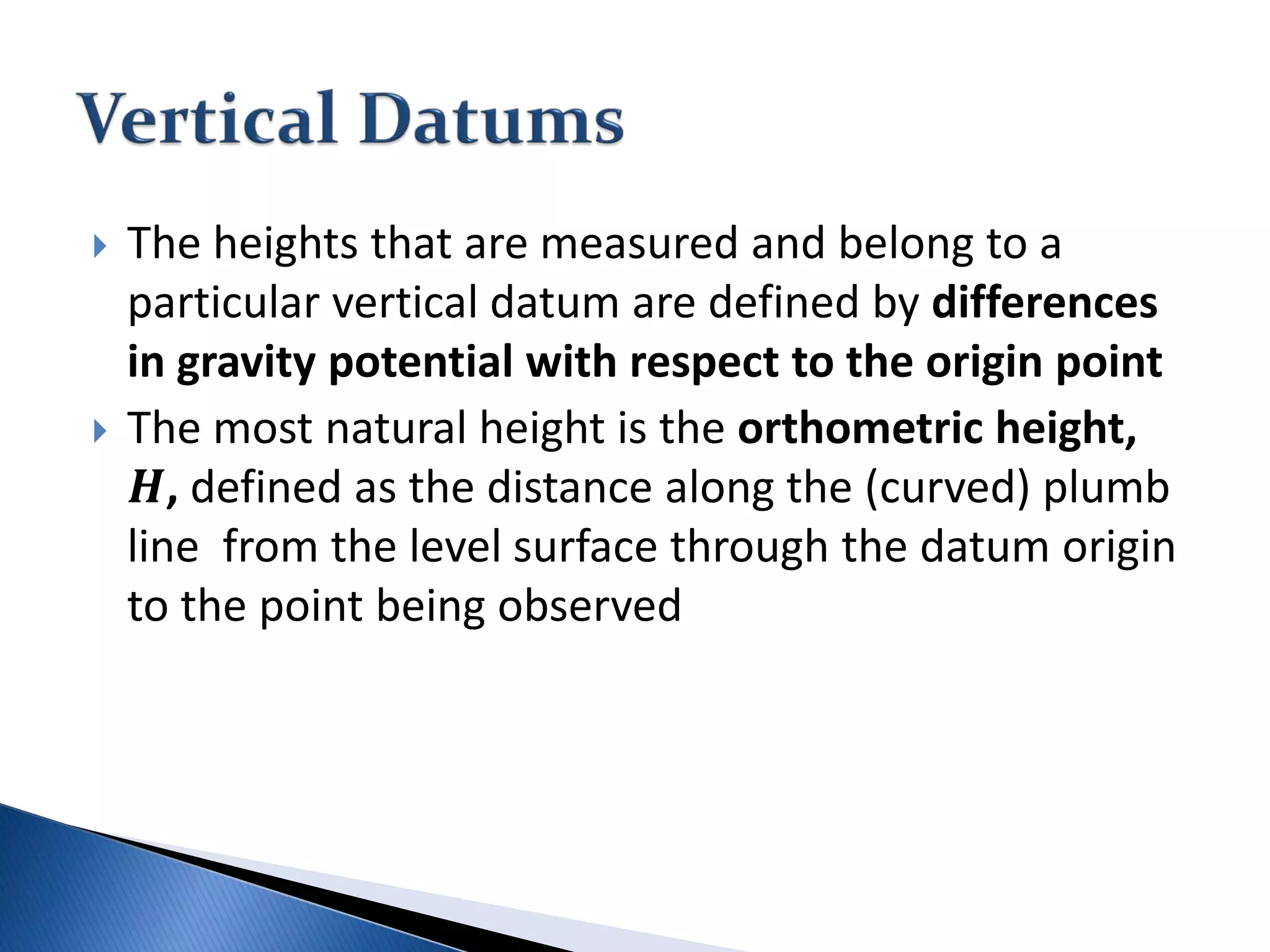
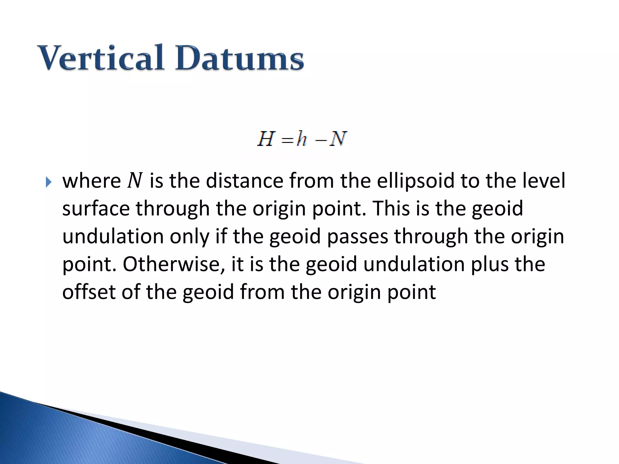
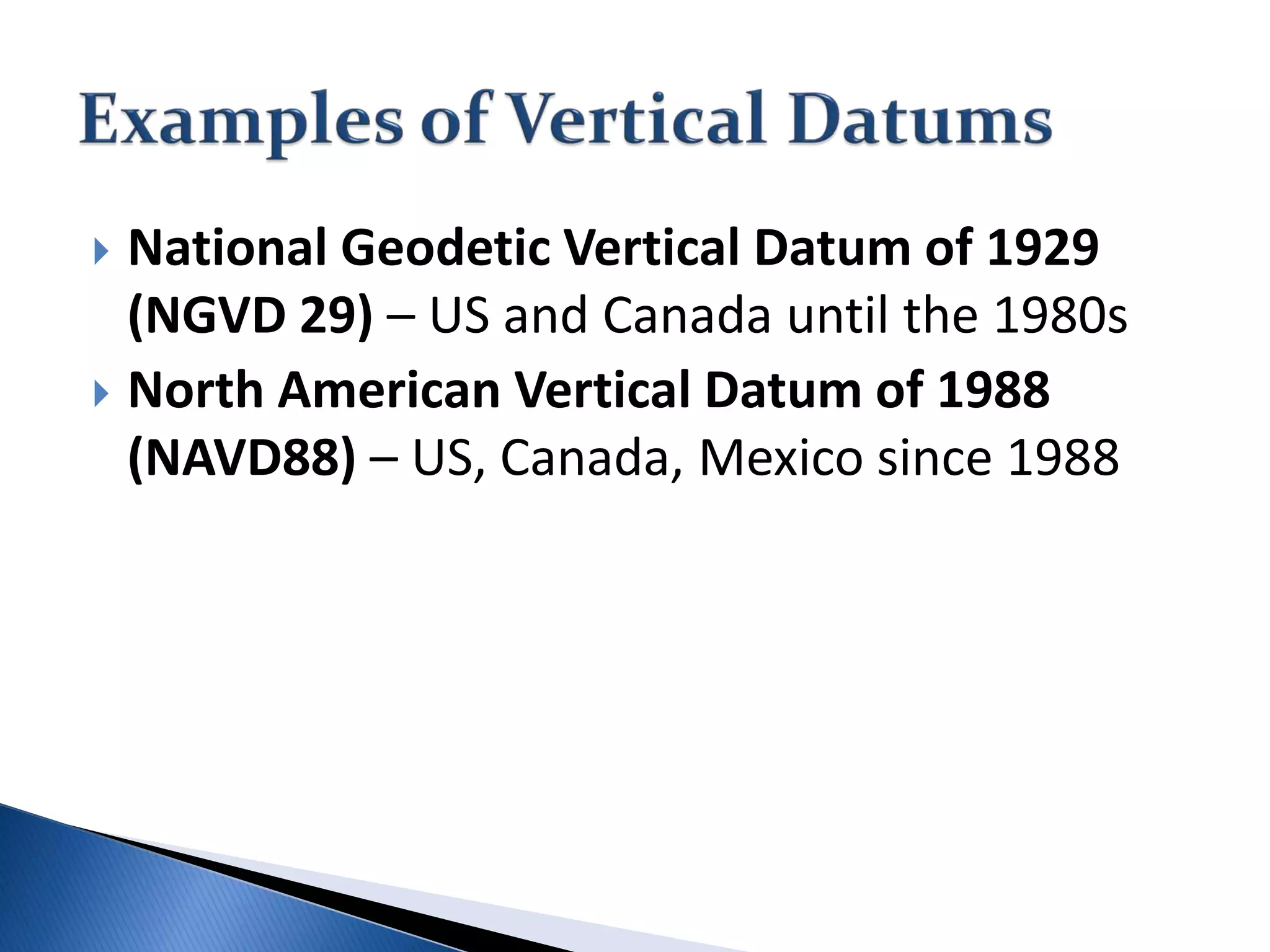
SlideShare a Scribd company logo
GE 152: Reference Systems and Reference Frames
Lecture 2 – 2nd Semester 2013-2014
Lecturer: Sheryl Rose C. Reyes
Department of Geodetic Engineering
 A Reference System is a set of prescriptions
and conventions together with modeling
required to define at any time a triad of
coordinate axes
 A Reference Frame realizes the system by
means of coordinates of definite points that
are accessible directly by occupation or by
observation
 Geodetic control at local, regional, national and
international levels have been revolutionized by the advent
of satellite systems that provide accurate positioning
capability to terrestrial observers at all scales, where of
course, the Global Positioning System (GPS) has had the
most significant impact
 Countries and continents around the world are revising, re-
defining and updating their fundamental networks to take
advantage of the high accuracy, the ease of establishing
and densifying the control and critically important, the
uniformity of the accuracy and the connectivity of the
control that can be achieved basically in a global setting.
NGS (1986): A set of constants specifying the coordinate
system used for geodetic control, i.e., for calculating
coordinates of points on the Earth.
Torge (1991): Defines the orientation of a conventional
[coordinate] system with respect to the global X,Y,Z-
system and hence with respect to the body of the Earth
Moritz (1978): A geodetic datum is usually defined in
terms of five parameters…
Ewing and Mitchell (1970): A geodetic datum is
comprised of an ellipsoid of revolution fixed in some
manner to the physical Earth
A Geodetic Datum is a set of parameters and
constants that defines a coordinate system,
including its origin and (where appropriate) its
orientation and scale, in such a way as to make
these accessible to geodetic applications. (Jekeli,
2006)
Note: Conceptually, the geodetic datum defines a
coordinate system, but once the parameters that
constitute a particular datum are specified, it takes on
the definition of a frame
 A horizontal geodetic datum is a geodetic
datum for horizontal geodetic control in which
points are mapped onto a specified ellipsoid
 A vertical geodetic datum is a geodetic datum
for vertical geodetic control in which points
are mapped to the geopotential
 The definition of any terrestrial coordinate system
requires the specification of its origin and its
orientation with respect to the Earth
 If geodetic coordinates are used one must specify the
ellipsoid to which they refer
 The definition of the traditional horizontal geodetic
datum is based on eight parameters: three to define its
origin, three to define its orientation and two to define
the ellipsoid
◦ These coordinate system attributes must be accessible,, that
is for its practical utilization, the coordinate system must be
realized as a frame
 The origin could be defined by identifying the
point (0,0,0) of the coordinate system with
the center of mass of the Earth
◦ Prior to the emergence of artificial satellites, this
origin is not accessible
◦ The ellipsoid thus positioned relative to the Earth
rarely “fit” the region in which geodetic control
was to be established
 The alternative definition of the “origin”
places the ellipsoid with respect to the Earth
such that a specific point on the Earth’s
surface has given (i.e. specified or defined)
geodetic coordinates
 This datum origin point, also call the initial
datum point, is then obviously accessible – it
is a monumented marker on the Earth
The Datum Origin Point
 The coordinates (𝜙𝜙0, 𝜆𝜆0, ℎ0), of the origin point can be
chosen arbitrarily, but usually they are determined
under an imposed additional condition that the
separation between the ellipsoid and the geoid in the
particular should be minimized:
 Where 𝐻𝐻0 is the height of the origin above the geoid
(the orthometric height); this is a measurable quantity,
again defined by nature
 Alternatively, we could also specify the deflection of
the vertical and geoid undulation at the origin point
(𝜉𝜉0, 𝜂𝜂0, 𝑁𝑁0). Then the geodetic latitude, longitude and
ellipsoidal height are not arbitrary, but are given by the
following equations:
Geoid undulation, 𝑵𝑵𝟎𝟎, at the origin point in general
 The horizontal geodetic datum as a reference system is
defined as a system of coordinates referring to an
ellipsoid whose origin is fixed to the Earth in some
prescribed way (e.g., by “attaching” the ellipsoid to a
monument on the Earth’s surface) and whose
orientation is defined with respect to the astronomic
system
 The datum as reference frame is realized by specifying
the two ellipsoid parameters (shape and scale), the
three origin point coordinates and the three
orientation parameters
 A vertical datum, like a horizontal datum, requires an
origin, but being one-dimensional, there is no
orientation; and the scale is inherent in the measuring
apparatus (leveling rods)
 The origin is a point on the Earth’s surface where the
height is a defined value (e.g., zero height at a coastal
tide-gauge station)
 Traditionally, a point at mean sea level served as origin
point, but is not important what the absolute gravity
potential is at this point, since one is interested only in
height differences
Two vertical datums with respect to mean sea level
 The heights that are measured and belong to a
particular vertical datum are defined by differences
in gravity potential with respect to the origin point
 The most natural height is the orthometric height,
𝑯𝑯, defined as the distance along the (curved) plumb
line from the level surface through the datum origin
to the point being observed
 where 𝑁𝑁 is the distance from the ellipsoid to the level
surface through the origin point. This is the geoid
undulation only if the geoid passes through the origin
point. Otherwise, it is the geoid undulation plus the
offset of the geoid from the origin point
 National Geodetic Vertical Datum of 1929
(NGVD 29) – US and Canada until the 1980s
 North American Vertical Datum of 1988
(NAVD88) – US, Canada, Mexico since 1988
 Jekeli, Christopher. "Geometric reference systems in
geodesy." Report, Division of Geodesy and Geospatial
Science, School of Earth Sciences, Ohio State University
(2006).
Ge152 lecture2 terrestrial reference systems_2nd_sem2013-2014_s_reyes

More Related Content

What's hot

Differentiation between Global and Local Datum from Different aspect
Differentiation between Global and Local Datum from Different aspect Differentiation between Global and Local Datum from Different aspect
Differentiation between Global and Local Datum from Different aspect
Nzar Braim
 
Datum
DatumDatum
Earth Coordinate Systems
Earth Coordinate Systems Earth Coordinate Systems
Earth Coordinate Systems
Sheikh Maryam
 
Introduction to MAPS,Coordinate System and Projection System
Introduction to MAPS,Coordinate System and Projection SystemIntroduction to MAPS,Coordinate System and Projection System
Introduction to MAPS,Coordinate System and Projection System
NAXA-Developers
 
Coordinate systems (Lecture 3)
Coordinate systems (Lecture 3)Coordinate systems (Lecture 3)
Coordinate systems (Lecture 3)
Olexiy Pogurelskiy
 
Basics of geodesy
Basics of geodesyBasics of geodesy
Basics of geodesy
Md. Yousuf Gazi
 
International spheroid[1]
International spheroid[1]International spheroid[1]
International spheroid[1]
Waleed Liaqat
 
2017 PLSC Track: Fundamentals of Coordinate Systems
2017 PLSC Track: Fundamentals of Coordinate Systems2017 PLSC Track: Fundamentals of Coordinate Systems
2017 PLSC Track: Fundamentals of Coordinate Systems
GIS in the Rockies
 
Basic of Geodesy
Basic of GeodesyBasic of Geodesy
Basic of Geodesy
Kutubuddin ANSARI
 
Projections and coordinate system
Projections and coordinate systemProjections and coordinate system
Projections and coordinate system
Mohsin Siddique
 
2018 GIS in the Rockies Workshop: Coordinate Systems and Projections
2018 GIS in the Rockies Workshop: Coordinate Systems and Projections 2018 GIS in the Rockies Workshop: Coordinate Systems and Projections
2018 GIS in the Rockies Workshop: Coordinate Systems and Projections
GIS in the Rockies
 
Coordinate systems
Coordinate systemsCoordinate systems
Coordinate systems
Reham Maher El-Safarini
 
Geographic coordinate system & map projection
Geographic coordinate system & map projectionGeographic coordinate system & map projection
Geographic coordinate system & map projection
vishalkedia119
 
Projections Eps
Projections EpsProjections Eps
Projections Eps
esambale
 
GEOID-DETERMINAION
GEOID-DETERMINAIONGEOID-DETERMINAION
GEOID-DETERMINAION
Radhika Bhandari
 
Presentation1.1
Presentation1.1Presentation1.1
Presentation1.1
Zahid22
 
Basic coordinate system
Basic coordinate systemBasic coordinate system
Basic coordinate system
Shayan Ahmad Yar
 
georeference
georeferencegeoreference
georeference
Thana Chirapiwat
 
Map projection
Map projectionMap projection
Map projection
Sumant Diwakar
 
Coordinate systems, datum & map projections
Coordinate systems, datum & map projectionsCoordinate systems, datum & map projections
Coordinate systems, datum & map projections
KU Leuven
 

What's hot (20)

Differentiation between Global and Local Datum from Different aspect
Differentiation between Global and Local Datum from Different aspect Differentiation between Global and Local Datum from Different aspect
Differentiation between Global and Local Datum from Different aspect
 
Datum
DatumDatum
Datum
 
Earth Coordinate Systems
Earth Coordinate Systems Earth Coordinate Systems
Earth Coordinate Systems
 
Introduction to MAPS,Coordinate System and Projection System
Introduction to MAPS,Coordinate System and Projection SystemIntroduction to MAPS,Coordinate System and Projection System
Introduction to MAPS,Coordinate System and Projection System
 
Coordinate systems (Lecture 3)
Coordinate systems (Lecture 3)Coordinate systems (Lecture 3)
Coordinate systems (Lecture 3)
 
Basics of geodesy
Basics of geodesyBasics of geodesy
Basics of geodesy
 
International spheroid[1]
International spheroid[1]International spheroid[1]
International spheroid[1]
 
2017 PLSC Track: Fundamentals of Coordinate Systems
2017 PLSC Track: Fundamentals of Coordinate Systems2017 PLSC Track: Fundamentals of Coordinate Systems
2017 PLSC Track: Fundamentals of Coordinate Systems
 
Basic of Geodesy
Basic of GeodesyBasic of Geodesy
Basic of Geodesy
 
Projections and coordinate system
Projections and coordinate systemProjections and coordinate system
Projections and coordinate system
 
2018 GIS in the Rockies Workshop: Coordinate Systems and Projections
2018 GIS in the Rockies Workshop: Coordinate Systems and Projections 2018 GIS in the Rockies Workshop: Coordinate Systems and Projections
2018 GIS in the Rockies Workshop: Coordinate Systems and Projections
 
Coordinate systems
Coordinate systemsCoordinate systems
Coordinate systems
 
Geographic coordinate system & map projection
Geographic coordinate system & map projectionGeographic coordinate system & map projection
Geographic coordinate system & map projection
 
Projections Eps
Projections EpsProjections Eps
Projections Eps
 
GEOID-DETERMINAION
GEOID-DETERMINAIONGEOID-DETERMINAION
GEOID-DETERMINAION
 
Presentation1.1
Presentation1.1Presentation1.1
Presentation1.1
 
Basic coordinate system
Basic coordinate systemBasic coordinate system
Basic coordinate system
 
georeference
georeferencegeoreference
georeference
 
Map projection
Map projectionMap projection
Map projection
 
Coordinate systems, datum & map projections
Coordinate systems, datum & map projectionsCoordinate systems, datum & map projections
Coordinate systems, datum & map projections
 

Viewers also liked

Geometric geodesy
Geometric geodesyGeometric geodesy
Geometric geodesy
Sanjit Bhattarai
 
Historical Review of Astro-Geodetic Observations in Serbia
Historical Review of Astro-Geodetic Observations in SerbiaHistorical Review of Astro-Geodetic Observations in Serbia
Historical Review of Astro-Geodetic Observations in Serbia
vogrizovic
 
A Construction of an Advanced System for Astro-Geodetic Determinations
A Construction of an Advanced System for Astro-Geodetic DeterminationsA Construction of an Advanced System for Astro-Geodetic Determinations
A Construction of an Advanced System for Astro-Geodetic Determinations
vogrizovic
 
geodetic system
geodetic systemgeodetic system
geodetic system
Jatin Saini
 
Presentasi pengetahuan peta by Akmalinda Ismail
Presentasi pengetahuan peta by Akmalinda IsmailPresentasi pengetahuan peta by Akmalinda Ismail
Presentasi pengetahuan peta by Akmalinda Ismail
Akmalinda Ismail
 
Transformasi Datum
Transformasi DatumTransformasi Datum
Transformasi Datum
National Cheng Kung University
 
Datums and Datum Targets
Datums and Datum TargetsDatums and Datum Targets
Datums and Datum Targets
Hassan Habib
 
Geodesy, Map Projections - Introduction
Geodesy, Map Projections - IntroductionGeodesy, Map Projections - Introduction
Geodesy, Map Projections - Introduction
Dean Mikkelsen
 
Class6 Earth Rotation And Revolution
Class6 Earth Rotation And RevolutionClass6 Earth Rotation And Revolution
Class6 Earth Rotation And Revolution
Pratibha Singh
 

Viewers also liked (10)

Geometric geodesy
Geometric geodesyGeometric geodesy
Geometric geodesy
 
Historical Review of Astro-Geodetic Observations in Serbia
Historical Review of Astro-Geodetic Observations in SerbiaHistorical Review of Astro-Geodetic Observations in Serbia
Historical Review of Astro-Geodetic Observations in Serbia
 
A Construction of an Advanced System for Astro-Geodetic Determinations
A Construction of an Advanced System for Astro-Geodetic DeterminationsA Construction of an Advanced System for Astro-Geodetic Determinations
A Construction of an Advanced System for Astro-Geodetic Determinations
 
geodetic system
geodetic systemgeodetic system
geodetic system
 
Presentasi pengetahuan peta by Akmalinda Ismail
Presentasi pengetahuan peta by Akmalinda IsmailPresentasi pengetahuan peta by Akmalinda Ismail
Presentasi pengetahuan peta by Akmalinda Ismail
 
Transformasi Datum
Transformasi DatumTransformasi Datum
Transformasi Datum
 
Iuw 5 pengetahuan peta
Iuw   5 pengetahuan petaIuw   5 pengetahuan peta
Iuw 5 pengetahuan peta
 
Datums and Datum Targets
Datums and Datum TargetsDatums and Datum Targets
Datums and Datum Targets
 
Geodesy, Map Projections - Introduction
Geodesy, Map Projections - IntroductionGeodesy, Map Projections - Introduction
Geodesy, Map Projections - Introduction
 
Class6 Earth Rotation And Revolution
Class6 Earth Rotation And RevolutionClass6 Earth Rotation And Revolution
Class6 Earth Rotation And Revolution
 

Similar to Ge152 lecture2 terrestrial reference systems_2nd_sem2013-2014_s_reyes

Coordinate system used in Satellite Navigation.pptx
Coordinate system used in Satellite Navigation.pptxCoordinate system used in Satellite Navigation.pptx
Coordinate system used in Satellite Navigation.pptx
QuotesBox
 
coordinate systems map projections and graphical and atoms ppt group (B).pptx
coordinate systems map projections and graphical and atoms ppt group (B).pptxcoordinate systems map projections and graphical and atoms ppt group (B).pptx
coordinate systems map projections and graphical and atoms ppt group (B).pptx
BakhtAli10
 
Understandingprojectionsforarcgis 12794889760059-phpapp01
Understandingprojectionsforarcgis 12794889760059-phpapp01Understandingprojectionsforarcgis 12794889760059-phpapp01
Understandingprojectionsforarcgis 12794889760059-phpapp01
Manisha Tomar
 
Gis georeference
Gis georeferenceGis georeference
Gis georeference
Shah Naseer
 
TYBSC IT PGIS Unit III Chapter I Spatial Referencing and Positioning
TYBSC IT PGIS Unit III Chapter I Spatial Referencing and PositioningTYBSC IT PGIS Unit III Chapter I Spatial Referencing and Positioning
TYBSC IT PGIS Unit III Chapter I Spatial Referencing and Positioning
Arti Parab Academics
 
coordinate systems map Projections and Atoms ppt - - Copy.pptx
coordinate systems map Projections  and Atoms ppt -  - Copy.pptxcoordinate systems map Projections  and Atoms ppt -  - Copy.pptx
coordinate systems map Projections and Atoms ppt - - Copy.pptx
BakhtAli10
 
geodesy-1 (1).pptx
geodesy-1 (1).pptxgeodesy-1 (1).pptx
geodesy-1 (1).pptx
DrOmegaYT
 
lecture_4_coordinate_system.pptx
lecture_4_coordinate_system.pptxlecture_4_coordinate_system.pptx
lecture_4_coordinate_system.pptx
ssuser79cb761
 
Understanding Coordinate Systems and Projections for ArcGIS
Understanding Coordinate Systems and Projections for ArcGISUnderstanding Coordinate Systems and Projections for ArcGIS
Understanding Coordinate Systems and Projections for ArcGIS
John Schaeffer
 
Satellite Geodesy Lecture Notes MSU 2015.pptx
Satellite Geodesy Lecture Notes MSU 2015.pptxSatellite Geodesy Lecture Notes MSU 2015.pptx
Satellite Geodesy Lecture Notes MSU 2015.pptx
TNNNelson
 
Hydrography
Hydrography Hydrography
Hydrography
Hafez Ahmad
 
GIS.pptx
GIS.pptxGIS.pptx
GIS.pptx
Tadele Fayissa
 
Fundamental Of Geodesy
Fundamental Of GeodesyFundamental Of Geodesy
Fundamental Of Geodesy
Dipendra kumar Yadav
 
inroduction to geodesy
inroduction to geodesyinroduction to geodesy
inroduction to geodesy
Dr.oday Zakariya Jasim
 
Hydrography documents
Hydrography documentsHydrography documents
Hydrography documents
Hafez Ahmad
 
Height systems and vertical datums
Height systems and vertical datumsHeight systems and vertical datums
Height systems and vertical datums
Ahmad Hasan
 
G0343052058
G0343052058G0343052058
G0343052058
ijceronline
 
Coordinate System.pdf
Coordinate System.pdfCoordinate System.pdf
Coordinate System.pdf
LareebMoeen1
 
Gis Concepts 3/5
Gis Concepts 3/5Gis Concepts 3/5
Gis Concepts 3/5
CIER Facultad de Agronomía
 
ELLIPSOID GEOMETRY TYPES OF LATITUDES OF ELLIPSOID.pptx
ELLIPSOID  GEOMETRY  TYPES OF LATITUDES OF ELLIPSOID.pptxELLIPSOID  GEOMETRY  TYPES OF LATITUDES OF ELLIPSOID.pptx
ELLIPSOID GEOMETRY TYPES OF LATITUDES OF ELLIPSOID.pptx
ChShakeelAhmedMayo
 

Similar to Ge152 lecture2 terrestrial reference systems_2nd_sem2013-2014_s_reyes (20)

Coordinate system used in Satellite Navigation.pptx
Coordinate system used in Satellite Navigation.pptxCoordinate system used in Satellite Navigation.pptx
Coordinate system used in Satellite Navigation.pptx
 
coordinate systems map projections and graphical and atoms ppt group (B).pptx
coordinate systems map projections and graphical and atoms ppt group (B).pptxcoordinate systems map projections and graphical and atoms ppt group (B).pptx
coordinate systems map projections and graphical and atoms ppt group (B).pptx
 
Understandingprojectionsforarcgis 12794889760059-phpapp01
Understandingprojectionsforarcgis 12794889760059-phpapp01Understandingprojectionsforarcgis 12794889760059-phpapp01
Understandingprojectionsforarcgis 12794889760059-phpapp01
 
Gis georeference
Gis georeferenceGis georeference
Gis georeference
 
TYBSC IT PGIS Unit III Chapter I Spatial Referencing and Positioning
TYBSC IT PGIS Unit III Chapter I Spatial Referencing and PositioningTYBSC IT PGIS Unit III Chapter I Spatial Referencing and Positioning
TYBSC IT PGIS Unit III Chapter I Spatial Referencing and Positioning
 
coordinate systems map Projections and Atoms ppt - - Copy.pptx
coordinate systems map Projections  and Atoms ppt -  - Copy.pptxcoordinate systems map Projections  and Atoms ppt -  - Copy.pptx
coordinate systems map Projections and Atoms ppt - - Copy.pptx
 
geodesy-1 (1).pptx
geodesy-1 (1).pptxgeodesy-1 (1).pptx
geodesy-1 (1).pptx
 
lecture_4_coordinate_system.pptx
lecture_4_coordinate_system.pptxlecture_4_coordinate_system.pptx
lecture_4_coordinate_system.pptx
 
Understanding Coordinate Systems and Projections for ArcGIS
Understanding Coordinate Systems and Projections for ArcGISUnderstanding Coordinate Systems and Projections for ArcGIS
Understanding Coordinate Systems and Projections for ArcGIS
 
Satellite Geodesy Lecture Notes MSU 2015.pptx
Satellite Geodesy Lecture Notes MSU 2015.pptxSatellite Geodesy Lecture Notes MSU 2015.pptx
Satellite Geodesy Lecture Notes MSU 2015.pptx
 
Hydrography
Hydrography Hydrography
Hydrography
 
GIS.pptx
GIS.pptxGIS.pptx
GIS.pptx
 
Fundamental Of Geodesy
Fundamental Of GeodesyFundamental Of Geodesy
Fundamental Of Geodesy
 
inroduction to geodesy
inroduction to geodesyinroduction to geodesy
inroduction to geodesy
 
Hydrography documents
Hydrography documentsHydrography documents
Hydrography documents
 
Height systems and vertical datums
Height systems and vertical datumsHeight systems and vertical datums
Height systems and vertical datums
 
G0343052058
G0343052058G0343052058
G0343052058
 
Coordinate System.pdf
Coordinate System.pdfCoordinate System.pdf
Coordinate System.pdf
 
Gis Concepts 3/5
Gis Concepts 3/5Gis Concepts 3/5
Gis Concepts 3/5
 
ELLIPSOID GEOMETRY TYPES OF LATITUDES OF ELLIPSOID.pptx
ELLIPSOID  GEOMETRY  TYPES OF LATITUDES OF ELLIPSOID.pptxELLIPSOID  GEOMETRY  TYPES OF LATITUDES OF ELLIPSOID.pptx
ELLIPSOID GEOMETRY TYPES OF LATITUDES OF ELLIPSOID.pptx
 

Recently uploaded

C1 Rubenstein AP HuG xxxxxxxxxxxxxx.pptx
C1 Rubenstein AP HuG xxxxxxxxxxxxxx.pptxC1 Rubenstein AP HuG xxxxxxxxxxxxxx.pptx
C1 Rubenstein AP HuG xxxxxxxxxxxxxx.pptx
mulvey2
 
คำศัพท์ คำพื้นฐานการอ่าน ภาษาอังกฤษ ระดับชั้น ม.1
คำศัพท์ คำพื้นฐานการอ่าน ภาษาอังกฤษ ระดับชั้น ม.1คำศัพท์ คำพื้นฐานการอ่าน ภาษาอังกฤษ ระดับชั้น ม.1
คำศัพท์ คำพื้นฐานการอ่าน ภาษาอังกฤษ ระดับชั้น ม.1
สมใจ จันสุกสี
 
Main Java[All of the Base Concepts}.docx
Main Java[All of the Base Concepts}.docxMain Java[All of the Base Concepts}.docx
Main Java[All of the Base Concepts}.docx
adhitya5119
 
Constructing Your Course Container for Effective Communication
Constructing Your Course Container for Effective CommunicationConstructing Your Course Container for Effective Communication
Constructing Your Course Container for Effective Communication
Chevonnese Chevers Whyte, MBA, B.Sc.
 
Pengantar Penggunaan Flutter - Dart programming language1.pptx
Pengantar Penggunaan Flutter - Dart programming language1.pptxPengantar Penggunaan Flutter - Dart programming language1.pptx
Pengantar Penggunaan Flutter - Dart programming language1.pptx
Fajar Baskoro
 
UGC NET Exam Paper 1- Unit 1:Teaching Aptitude
UGC NET Exam Paper 1- Unit 1:Teaching AptitudeUGC NET Exam Paper 1- Unit 1:Teaching Aptitude
UGC NET Exam Paper 1- Unit 1:Teaching Aptitude
S. Raj Kumar
 
math operations ued in python and all used
math operations ued in python and all usedmath operations ued in python and all used
math operations ued in python and all used
ssuser13ffe4
 
Beyond Degrees - Empowering the Workforce in the Context of Skills-First.pptx
Beyond Degrees - Empowering the Workforce in the Context of Skills-First.pptxBeyond Degrees - Empowering the Workforce in the Context of Skills-First.pptx
Beyond Degrees - Empowering the Workforce in the Context of Skills-First.pptx
EduSkills OECD
 
The basics of sentences session 6pptx.pptx
The basics of sentences session 6pptx.pptxThe basics of sentences session 6pptx.pptx
The basics of sentences session 6pptx.pptx
heathfieldcps1
 
NEWSPAPERS - QUESTION 1 - REVISION POWERPOINT.pptx
NEWSPAPERS - QUESTION 1 - REVISION POWERPOINT.pptxNEWSPAPERS - QUESTION 1 - REVISION POWERPOINT.pptx
NEWSPAPERS - QUESTION 1 - REVISION POWERPOINT.pptx
iammrhaywood
 
বাংলাদেশ অর্থনৈতিক সমীক্ষা (Economic Review) ২০২৪ UJS App.pdf
বাংলাদেশ অর্থনৈতিক সমীক্ষা (Economic Review) ২০২৪ UJS App.pdfবাংলাদেশ অর্থনৈতিক সমীক্ষা (Economic Review) ২০২৪ UJS App.pdf
বাংলাদেশ অর্থনৈতিক সমীক্ষা (Economic Review) ২০২৪ UJS App.pdf
eBook.com.bd (প্রয়োজনীয় বাংলা বই)
 
writing about opinions about Australia the movie
writing about opinions about Australia the moviewriting about opinions about Australia the movie
writing about opinions about Australia the movie
Nicholas Montgomery
 
Chapter wise All Notes of First year Basic Civil Engineering.pptx
Chapter wise All Notes of First year Basic Civil Engineering.pptxChapter wise All Notes of First year Basic Civil Engineering.pptx
Chapter wise All Notes of First year Basic Civil Engineering.pptx
Denish Jangid
 
Mule event processing models | MuleSoft Mysore Meetup #47
Mule event processing models | MuleSoft Mysore Meetup #47Mule event processing models | MuleSoft Mysore Meetup #47
Mule event processing models | MuleSoft Mysore Meetup #47
MysoreMuleSoftMeetup
 
Leveraging Generative AI to Drive Nonprofit Innovation
Leveraging Generative AI to Drive Nonprofit InnovationLeveraging Generative AI to Drive Nonprofit Innovation
Leveraging Generative AI to Drive Nonprofit Innovation
TechSoup
 
MARY JANE WILSON, A “BOA MÃE” .
MARY JANE WILSON, A “BOA MÃE”           .MARY JANE WILSON, A “BOA MÃE”           .
MARY JANE WILSON, A “BOA MÃE” .
Colégio Santa Teresinha
 
Wound healing PPT
Wound healing PPTWound healing PPT
Wound healing PPT
Jyoti Chand
 
Gender and Mental Health - Counselling and Family Therapy Applications and In...
Gender and Mental Health - Counselling and Family Therapy Applications and In...Gender and Mental Health - Counselling and Family Therapy Applications and In...
Gender and Mental Health - Counselling and Family Therapy Applications and In...
PsychoTech Services
 
BÀI TẬP BỔ TRỢ TIẾNG ANH LỚP 9 CẢ NĂM - GLOBAL SUCCESS - NĂM HỌC 2024-2025 - ...
BÀI TẬP BỔ TRỢ TIẾNG ANH LỚP 9 CẢ NĂM - GLOBAL SUCCESS - NĂM HỌC 2024-2025 - ...BÀI TẬP BỔ TRỢ TIẾNG ANH LỚP 9 CẢ NĂM - GLOBAL SUCCESS - NĂM HỌC 2024-2025 - ...
BÀI TẬP BỔ TRỢ TIẾNG ANH LỚP 9 CẢ NĂM - GLOBAL SUCCESS - NĂM HỌC 2024-2025 - ...
Nguyen Thanh Tu Collection
 
The History of Stoke Newington Street Names
The History of Stoke Newington Street NamesThe History of Stoke Newington Street Names
The History of Stoke Newington Street Names
History of Stoke Newington
 

Recently uploaded (20)

C1 Rubenstein AP HuG xxxxxxxxxxxxxx.pptx
C1 Rubenstein AP HuG xxxxxxxxxxxxxx.pptxC1 Rubenstein AP HuG xxxxxxxxxxxxxx.pptx
C1 Rubenstein AP HuG xxxxxxxxxxxxxx.pptx
 
คำศัพท์ คำพื้นฐานการอ่าน ภาษาอังกฤษ ระดับชั้น ม.1
คำศัพท์ คำพื้นฐานการอ่าน ภาษาอังกฤษ ระดับชั้น ม.1คำศัพท์ คำพื้นฐานการอ่าน ภาษาอังกฤษ ระดับชั้น ม.1
คำศัพท์ คำพื้นฐานการอ่าน ภาษาอังกฤษ ระดับชั้น ม.1
 
Main Java[All of the Base Concepts}.docx
Main Java[All of the Base Concepts}.docxMain Java[All of the Base Concepts}.docx
Main Java[All of the Base Concepts}.docx
 
Constructing Your Course Container for Effective Communication
Constructing Your Course Container for Effective CommunicationConstructing Your Course Container for Effective Communication
Constructing Your Course Container for Effective Communication
 
Pengantar Penggunaan Flutter - Dart programming language1.pptx
Pengantar Penggunaan Flutter - Dart programming language1.pptxPengantar Penggunaan Flutter - Dart programming language1.pptx
Pengantar Penggunaan Flutter - Dart programming language1.pptx
 
UGC NET Exam Paper 1- Unit 1:Teaching Aptitude
UGC NET Exam Paper 1- Unit 1:Teaching AptitudeUGC NET Exam Paper 1- Unit 1:Teaching Aptitude
UGC NET Exam Paper 1- Unit 1:Teaching Aptitude
 
math operations ued in python and all used
math operations ued in python and all usedmath operations ued in python and all used
math operations ued in python and all used
 
Beyond Degrees - Empowering the Workforce in the Context of Skills-First.pptx
Beyond Degrees - Empowering the Workforce in the Context of Skills-First.pptxBeyond Degrees - Empowering the Workforce in the Context of Skills-First.pptx
Beyond Degrees - Empowering the Workforce in the Context of Skills-First.pptx
 
The basics of sentences session 6pptx.pptx
The basics of sentences session 6pptx.pptxThe basics of sentences session 6pptx.pptx
The basics of sentences session 6pptx.pptx
 
NEWSPAPERS - QUESTION 1 - REVISION POWERPOINT.pptx
NEWSPAPERS - QUESTION 1 - REVISION POWERPOINT.pptxNEWSPAPERS - QUESTION 1 - REVISION POWERPOINT.pptx
NEWSPAPERS - QUESTION 1 - REVISION POWERPOINT.pptx
 
বাংলাদেশ অর্থনৈতিক সমীক্ষা (Economic Review) ২০২৪ UJS App.pdf
বাংলাদেশ অর্থনৈতিক সমীক্ষা (Economic Review) ২০২৪ UJS App.pdfবাংলাদেশ অর্থনৈতিক সমীক্ষা (Economic Review) ২০২৪ UJS App.pdf
বাংলাদেশ অর্থনৈতিক সমীক্ষা (Economic Review) ২০২৪ UJS App.pdf
 
writing about opinions about Australia the movie
writing about opinions about Australia the moviewriting about opinions about Australia the movie
writing about opinions about Australia the movie
 
Chapter wise All Notes of First year Basic Civil Engineering.pptx
Chapter wise All Notes of First year Basic Civil Engineering.pptxChapter wise All Notes of First year Basic Civil Engineering.pptx
Chapter wise All Notes of First year Basic Civil Engineering.pptx
 
Mule event processing models | MuleSoft Mysore Meetup #47
Mule event processing models | MuleSoft Mysore Meetup #47Mule event processing models | MuleSoft Mysore Meetup #47
Mule event processing models | MuleSoft Mysore Meetup #47
 
Leveraging Generative AI to Drive Nonprofit Innovation
Leveraging Generative AI to Drive Nonprofit InnovationLeveraging Generative AI to Drive Nonprofit Innovation
Leveraging Generative AI to Drive Nonprofit Innovation
 
MARY JANE WILSON, A “BOA MÃE” .
MARY JANE WILSON, A “BOA MÃE”           .MARY JANE WILSON, A “BOA MÃE”           .
MARY JANE WILSON, A “BOA MÃE” .
 
Wound healing PPT
Wound healing PPTWound healing PPT
Wound healing PPT
 
Gender and Mental Health - Counselling and Family Therapy Applications and In...
Gender and Mental Health - Counselling and Family Therapy Applications and In...Gender and Mental Health - Counselling and Family Therapy Applications and In...
Gender and Mental Health - Counselling and Family Therapy Applications and In...
 
BÀI TẬP BỔ TRỢ TIẾNG ANH LỚP 9 CẢ NĂM - GLOBAL SUCCESS - NĂM HỌC 2024-2025 - ...
BÀI TẬP BỔ TRỢ TIẾNG ANH LỚP 9 CẢ NĂM - GLOBAL SUCCESS - NĂM HỌC 2024-2025 - ...BÀI TẬP BỔ TRỢ TIẾNG ANH LỚP 9 CẢ NĂM - GLOBAL SUCCESS - NĂM HỌC 2024-2025 - ...
BÀI TẬP BỔ TRỢ TIẾNG ANH LỚP 9 CẢ NĂM - GLOBAL SUCCESS - NĂM HỌC 2024-2025 - ...
 
The History of Stoke Newington Street Names
The History of Stoke Newington Street NamesThe History of Stoke Newington Street Names
The History of Stoke Newington Street Names
 

Ge152 lecture2 terrestrial reference systems_2nd_sem2013-2014_s_reyes

  • 1. GE 152: Reference Systems and Reference Frames Lecture 2 – 2nd Semester 2013-2014 Lecturer: Sheryl Rose C. Reyes Department of Geodetic Engineering
  • 2.  A Reference System is a set of prescriptions and conventions together with modeling required to define at any time a triad of coordinate axes  A Reference Frame realizes the system by means of coordinates of definite points that are accessible directly by occupation or by observation
  • 3.  Geodetic control at local, regional, national and international levels have been revolutionized by the advent of satellite systems that provide accurate positioning capability to terrestrial observers at all scales, where of course, the Global Positioning System (GPS) has had the most significant impact  Countries and continents around the world are revising, re- defining and updating their fundamental networks to take advantage of the high accuracy, the ease of establishing and densifying the control and critically important, the uniformity of the accuracy and the connectivity of the control that can be achieved basically in a global setting.
  • 4. NGS (1986): A set of constants specifying the coordinate system used for geodetic control, i.e., for calculating coordinates of points on the Earth. Torge (1991): Defines the orientation of a conventional [coordinate] system with respect to the global X,Y,Z- system and hence with respect to the body of the Earth Moritz (1978): A geodetic datum is usually defined in terms of five parameters… Ewing and Mitchell (1970): A geodetic datum is comprised of an ellipsoid of revolution fixed in some manner to the physical Earth
  • 5. A Geodetic Datum is a set of parameters and constants that defines a coordinate system, including its origin and (where appropriate) its orientation and scale, in such a way as to make these accessible to geodetic applications. (Jekeli, 2006) Note: Conceptually, the geodetic datum defines a coordinate system, but once the parameters that constitute a particular datum are specified, it takes on the definition of a frame
  • 6.  A horizontal geodetic datum is a geodetic datum for horizontal geodetic control in which points are mapped onto a specified ellipsoid  A vertical geodetic datum is a geodetic datum for vertical geodetic control in which points are mapped to the geopotential
  • 7.  The definition of any terrestrial coordinate system requires the specification of its origin and its orientation with respect to the Earth  If geodetic coordinates are used one must specify the ellipsoid to which they refer  The definition of the traditional horizontal geodetic datum is based on eight parameters: three to define its origin, three to define its orientation and two to define the ellipsoid ◦ These coordinate system attributes must be accessible,, that is for its practical utilization, the coordinate system must be realized as a frame
  • 8.  The origin could be defined by identifying the point (0,0,0) of the coordinate system with the center of mass of the Earth ◦ Prior to the emergence of artificial satellites, this origin is not accessible ◦ The ellipsoid thus positioned relative to the Earth rarely “fit” the region in which geodetic control was to be established
  • 9.  The alternative definition of the “origin” places the ellipsoid with respect to the Earth such that a specific point on the Earth’s surface has given (i.e. specified or defined) geodetic coordinates  This datum origin point, also call the initial datum point, is then obviously accessible – it is a monumented marker on the Earth
  • 11.
  • 12.  The coordinates (𝜙𝜙0, 𝜆𝜆0, ℎ0), of the origin point can be chosen arbitrarily, but usually they are determined under an imposed additional condition that the separation between the ellipsoid and the geoid in the particular should be minimized:  Where 𝐻𝐻0 is the height of the origin above the geoid (the orthometric height); this is a measurable quantity, again defined by nature
  • 13.  Alternatively, we could also specify the deflection of the vertical and geoid undulation at the origin point (𝜉𝜉0, 𝜂𝜂0, 𝑁𝑁0). Then the geodetic latitude, longitude and ellipsoidal height are not arbitrary, but are given by the following equations:
  • 14. Geoid undulation, 𝑵𝑵𝟎𝟎, at the origin point in general
  • 15.  The horizontal geodetic datum as a reference system is defined as a system of coordinates referring to an ellipsoid whose origin is fixed to the Earth in some prescribed way (e.g., by “attaching” the ellipsoid to a monument on the Earth’s surface) and whose orientation is defined with respect to the astronomic system  The datum as reference frame is realized by specifying the two ellipsoid parameters (shape and scale), the three origin point coordinates and the three orientation parameters
  • 16.
  • 17.
  • 18.  A vertical datum, like a horizontal datum, requires an origin, but being one-dimensional, there is no orientation; and the scale is inherent in the measuring apparatus (leveling rods)  The origin is a point on the Earth’s surface where the height is a defined value (e.g., zero height at a coastal tide-gauge station)  Traditionally, a point at mean sea level served as origin point, but is not important what the absolute gravity potential is at this point, since one is interested only in height differences
  • 19. Two vertical datums with respect to mean sea level
  • 20.  The heights that are measured and belong to a particular vertical datum are defined by differences in gravity potential with respect to the origin point  The most natural height is the orthometric height, 𝑯𝑯, defined as the distance along the (curved) plumb line from the level surface through the datum origin to the point being observed
  • 21.  where 𝑁𝑁 is the distance from the ellipsoid to the level surface through the origin point. This is the geoid undulation only if the geoid passes through the origin point. Otherwise, it is the geoid undulation plus the offset of the geoid from the origin point
  • 22.  National Geodetic Vertical Datum of 1929 (NGVD 29) – US and Canada until the 1980s  North American Vertical Datum of 1988 (NAVD88) – US, Canada, Mexico since 1988
  • 23.  Jekeli, Christopher. "Geometric reference systems in geodesy." Report, Division of Geodesy and Geospatial Science, School of Earth Sciences, Ohio State University (2006).