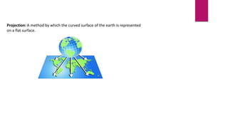
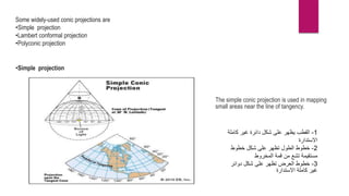
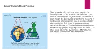
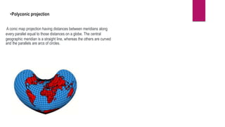
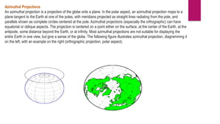
SlideShare a Scribd company logo
Chart Projection
COASTAL NAVIGATION AND
CHART WORK
UN 103
Projection: A method by which the curved surface of the earth is represented
on a flat surface.
The Desirable property of the preferable projection
1- keep the natural object shape on earth equivalent
2- keep the angular relation between the object equivalent to the real
3- well represent the area as the actual
4- provide a fixed scale to measure the distance
5- Great circles appear as straight lines
6- the rump line appear as straight lines
 Earth is in fact flattened slightly at the poles and bulges somewhat at the
equator.
 Mathematical Shape of the earth : An Ellipsoid, A geometrical figure which
would be obtained by rotating an ellipse about its shorter axis.
The requirement of a chart appropriate for maritime navigation
1-flat surface
2-The figure that is seen on the Earth is exactly the same as the
that is seen on the map
3- the rump line appear as straight lines
4- Possibility to measure course line, directions, and distances
5- Possibility to locate the ship’s position latitude and longitude.
Type of projection
1- CONVENTIONAL PROJECTION
AN EXAMPLE OF THIS
PROJECTION IS THE MOLLWIEDE
PROJECTION
Pros:
•Gives a more accurate visual
•Improved map, following the Robinson
•Less distortion, more proportional
Cons:
•No line of latitude or longitude represents accurate
location
•Poor directional map
Mollweide Projection
projection derived from cone
Conic Projections
Azimuthal Projections
Cylindrical Projections
Conic Projections
A conic projection is derived from the projection of the globe onto a cone placed over it. For the normal aspect, the
apex of the cone lies on the polar axis of the Earth. If the cone touches the Earth at just one particular parallel of
latitude, it is called a tangent. If made smaller, the cone will intersect the Earth twice, in which case it is called secant.
Conic projections often achieve less distortion at mid- and high latitudes than cylindrical projections. Further
elaboration is the polyconic projection, which deploys a family of tangent or secant cones to bracket a succession of
bands of parallels to yield even less scale distortion. The following figure illustrates conic projection, diagramming its
construction on the left, with an example on the right (Albers equal-area projection, polar aspect).
Some widely-used conic projections are
•Simple projection
•Lambert conformal projection
•Polyconic projection
•Simple projection
The simple conic projection is used in mapping
small areas near the line of tangency.
1
-
‫كاملة‬ ‫غير‬ ‫دائرة‬ ‫شكل‬ ‫على‬ ‫يظهر‬ ‫القطب‬
‫االستدارة‬
2
-
‫خطوط‬ ‫شكل‬ ‫على‬ ‫تظهر‬ ‫الطول‬ ‫خطوط‬
‫المخروط‬ ‫قمة‬ ‫من‬ ‫تشع‬ ‫مستقيمة‬
3
-
‫دوائر‬ ‫شكل‬ ‫على‬ ‫تظهر‬ ‫العرض‬ ‫خطوط‬
‫االستدارة‬ ‫كاملة‬ ‫غير‬
Lambert Conformal Conic Projection
The Lambert conformal conic map projection is
typically based on two standard parallels, but it can
also be defined with a single standard parallel and a
scale factor. It is best suited for conformal mapping of
landmasses extending in an east-to-west orientation
at mid-latitudes. This projection was rarely used
before the First World War but is now commonly used
for official topographic mapping around the world. The
state plane coordinate system uses it for all zones
that have a predominant east-west extent.
•Polyconic projection
A conic map projection having distances between meridians along
every parallel equal to those distances on a globe. The central
geographic meridian is a straight line, whereas the others are curved
and the parallels are arcs of circles.
Azimuthal Projections
An azimuthal projection is a projection of the globe onto a plane. In the polar aspect, an azimuthal projection maps to a
plane tangent to the Earth at one of the poles, with meridians projected as straight lines radiating from the pole, and
parallels shown as complete circles centered at the pole. Azimuthal projections (especially the orthographic) can have
equatorial or oblique aspects. The projection is centered on a point either on the surface, at the center of the Earth, at the
antipode, some distance beyond the Earth, or at infinity. Most azimuthal projections are not suitable for displaying the
entire Earth in one view, but give a sense of the globe. The following figure illustrates azimuthal projection, diagramming it
on the left, with an example on the right (orthographic projection, polar aspect).
Stereographic projection
This considers an opposite extreme point in the globe. The most common
are used as a reference, although in that case it would be called polar
It is also characterized because the parallels become closer as they go
circle is reflected as a semicircle or as a straight line.
Orthographic projection
It is used to have a vision of the hemispheres but from the perspective of
form are distorted and the distances are real, especially those that are around
Gnomonic projection
In this projection all the points are projected towards a tangent plane,
Earth.
It is usually used by navigators and pilots because the circular patterns of the
straight lines, showing shorter routes to follow.
It should be noted that although there are technological advances through
routes, the use of paper still persists.
type of azimuthal projections
Gnomonic projection
• Gnomonic: light projected from center of globe to
projection surface.
Stereographic projection
• light projected from
antipode of point of tangency
Orthographic projection
Orthographic: light projected from infinity
cylindrical projections

More Related Content

What's hot

Commonly used ground truth equipments
Commonly used ground truth equipmentsCommonly used ground truth equipments
Commonly used ground truth equipments
HimangshuKalita10
 
Fundamentals of Remote Sensing
Fundamentals of Remote SensingFundamentals of Remote Sensing
Fundamentals of Remote Sensing
Shah Naseer
 
Synthetic aperture radar
Synthetic aperture radarSynthetic aperture radar
Synthetic aperture radar
Mahesh pawar
 
Remote sensing - Scanners
Remote sensing - ScannersRemote sensing - Scanners
Remote sensing - Scanners
Pramoda Raj
 
Spot satellite
Spot satelliteSpot satellite
Spot satellite
titus chapukira
 
8.Charts
8.Charts8.Charts
8.Charts
AmenBAL
 
A Brief Introduction to Remote Sensing Satellites
A Brief Introduction to Remote Sensing Satellites A Brief Introduction to Remote Sensing Satellites
A Brief Introduction to Remote Sensing Satellites
Alireza Rahimzadeganasl
 
Indian remote sensing
Indian remote sensingIndian remote sensing
Indian remote sensing
Sumant Diwakar
 
Spectral reflectance curve of dead stressed vegetation
Spectral reflectance curve of dead stressed vegetationSpectral reflectance curve of dead stressed vegetation
Spectral reflectance curve of dead stressed vegetation
Junaid Ijaz
 
Introduction to global position system
Introduction to global position systemIntroduction to global position system
Introduction to global position system
University of Technology
 
Coordinate systems, datum & map projections
Coordinate systems, datum & map projectionsCoordinate systems, datum & map projections
Coordinate systems, datum & map projections
KU Leuven
 
Geospatial reference-systems
Geospatial reference-systemsGeospatial reference-systems
Geospatial reference-systems
Stephen
 
The Continental Margins
The Continental MarginsThe Continental Margins
The Continental Margins
Prof. A.Balasubramanian
 
Explosive and non explosive energy sources in marine acquisition ( overview )
Explosive and non explosive energy sources in marine acquisition ( overview )Explosive and non explosive energy sources in marine acquisition ( overview )
Explosive and non explosive energy sources in marine acquisition ( overview )
Ali M. Abdelsamad
 
Types of scanners
Types of scannersTypes of scanners
Types of scanners
Pramoda Raj
 
Indian remote sensing satellites
Indian  remote  sensing  satellitesIndian  remote  sensing  satellites
Indian remote sensing satellites
Pramoda Raj
 
Remote Sensing Platforms and Its types
Remote Sensing Platforms and Its typesRemote Sensing Platforms and Its types
Remote Sensing Platforms and Its types
Senthamizhan M
 
gis
gisgis
gis
yaesh
 
Landsat
LandsatLandsat
Landsat
HARITHANAIR15
 
Microwave remote sensing
Microwave remote sensingMicrowave remote sensing
Microwave remote sensing
Rohit Kumar
 

What's hot (20)

Commonly used ground truth equipments
Commonly used ground truth equipmentsCommonly used ground truth equipments
Commonly used ground truth equipments
 
Fundamentals of Remote Sensing
Fundamentals of Remote SensingFundamentals of Remote Sensing
Fundamentals of Remote Sensing
 
Synthetic aperture radar
Synthetic aperture radarSynthetic aperture radar
Synthetic aperture radar
 
Remote sensing - Scanners
Remote sensing - ScannersRemote sensing - Scanners
Remote sensing - Scanners
 
Spot satellite
Spot satelliteSpot satellite
Spot satellite
 
8.Charts
8.Charts8.Charts
8.Charts
 
A Brief Introduction to Remote Sensing Satellites
A Brief Introduction to Remote Sensing Satellites A Brief Introduction to Remote Sensing Satellites
A Brief Introduction to Remote Sensing Satellites
 
Indian remote sensing
Indian remote sensingIndian remote sensing
Indian remote sensing
 
Spectral reflectance curve of dead stressed vegetation
Spectral reflectance curve of dead stressed vegetationSpectral reflectance curve of dead stressed vegetation
Spectral reflectance curve of dead stressed vegetation
 
Introduction to global position system
Introduction to global position systemIntroduction to global position system
Introduction to global position system
 
Coordinate systems, datum & map projections
Coordinate systems, datum & map projectionsCoordinate systems, datum & map projections
Coordinate systems, datum & map projections
 
Geospatial reference-systems
Geospatial reference-systemsGeospatial reference-systems
Geospatial reference-systems
 
The Continental Margins
The Continental MarginsThe Continental Margins
The Continental Margins
 
Explosive and non explosive energy sources in marine acquisition ( overview )
Explosive and non explosive energy sources in marine acquisition ( overview )Explosive and non explosive energy sources in marine acquisition ( overview )
Explosive and non explosive energy sources in marine acquisition ( overview )
 
Types of scanners
Types of scannersTypes of scanners
Types of scanners
 
Indian remote sensing satellites
Indian  remote  sensing  satellitesIndian  remote  sensing  satellites
Indian remote sensing satellites
 
Remote Sensing Platforms and Its types
Remote Sensing Platforms and Its typesRemote Sensing Platforms and Its types
Remote Sensing Platforms and Its types
 
gis
gisgis
gis
 
Landsat
LandsatLandsat
Landsat
 
Microwave remote sensing
Microwave remote sensingMicrowave remote sensing
Microwave remote sensing
 

Similar to chart projection

MAP PROJECTION.pdf
MAP PROJECTION.pdfMAP PROJECTION.pdf
MAP PROJECTION.pdf
raziaramzan1
 
Cartography Unit_ 3.pptx
Cartography Unit_ 3.pptxCartography Unit_ 3.pptx
Cartography Unit_ 3.pptx
warkisafile1
 
Surveying ii ajith sir class 2,3,4
Surveying ii ajith sir class 2,3,4Surveying ii ajith sir class 2,3,4
Surveying ii ajith sir class 2,3,4
SHAMJITH KM
 
Projection
ProjectionProjection
Projection
SUPARNA DEY
 
PROJECTIONS & COORDINATE SYSTEMS-1.pptx
PROJECTIONS & COORDINATE SYSTEMS-1.pptxPROJECTIONS & COORDINATE SYSTEMS-1.pptx
PROJECTIONS & COORDINATE SYSTEMS-1.pptx
SaitarunKuna
 
Map projections
Map projectionsMap projections
Map projections
Shaina Mavreen Villaroza
 
Map projections and its types explanation and examples.pptx
Map projections and its types explanation and examples.pptxMap projections and its types explanation and examples.pptx
Map projections and its types explanation and examples.pptx
ChShakeelAhmedMayo
 
Map Projection
Map ProjectionMap Projection
Map Projection
AvinashAvi110
 
Cartographic Projections
Cartographic ProjectionsCartographic Projections
Cartographic Projections
María Jesús Campos Fernández
 
Mappingthesphere 121121234343-phpapp02
Mappingthesphere 121121234343-phpapp02Mappingthesphere 121121234343-phpapp02
Mappingthesphere 121121234343-phpapp02
Casmir Senior
 
Map projection
Map projection Map projection
Map projection
Pramoda Raj
 
Combined gis 2(GEOGRAPHIC INFORMATION SYSTEM)
Combined gis 2(GEOGRAPHIC INFORMATION SYSTEM)Combined gis 2(GEOGRAPHIC INFORMATION SYSTEM)
Combined gis 2(GEOGRAPHIC INFORMATION SYSTEM)
musadoto
 
Basic Geodesy.pdf
Basic Geodesy.pdfBasic Geodesy.pdf
Basic Geodesy.pdf
RamMishra65
 
MAP PROJECTIONS LECTURE_removed.pdf
MAP PROJECTIONS LECTURE_removed.pdfMAP PROJECTIONS LECTURE_removed.pdf
MAP PROJECTIONS LECTURE_removed.pdf
DvyneJosef
 
Projections and coordinate system
Projections and coordinate systemProjections and coordinate system
Projections and coordinate system
Mohsin Siddique
 
projection.pptx
projection.pptxprojection.pptx
projection.pptx
AsmitaKanav1
 
Latitude
LatitudeLatitude
Latitude
mkjhfasjks
 
Earth Coordinate Systems
Earth Coordinate Systems Earth Coordinate Systems
Earth Coordinate Systems
Sheikh Maryam
 
projection
projectionprojection
projection
Preeti Tiwari
 
Mapping the sphere
Mapping the sphereMapping the sphere
Mapping the sphere
Tarun Gehlot
 

Similar to chart projection (20)

MAP PROJECTION.pdf
MAP PROJECTION.pdfMAP PROJECTION.pdf
MAP PROJECTION.pdf
 
Cartography Unit_ 3.pptx
Cartography Unit_ 3.pptxCartography Unit_ 3.pptx
Cartography Unit_ 3.pptx
 
Surveying ii ajith sir class 2,3,4
Surveying ii ajith sir class 2,3,4Surveying ii ajith sir class 2,3,4
Surveying ii ajith sir class 2,3,4
 
Projection
ProjectionProjection
Projection
 
PROJECTIONS & COORDINATE SYSTEMS-1.pptx
PROJECTIONS & COORDINATE SYSTEMS-1.pptxPROJECTIONS & COORDINATE SYSTEMS-1.pptx
PROJECTIONS & COORDINATE SYSTEMS-1.pptx
 
Map projections
Map projectionsMap projections
Map projections
 
Map projections and its types explanation and examples.pptx
Map projections and its types explanation and examples.pptxMap projections and its types explanation and examples.pptx
Map projections and its types explanation and examples.pptx
 
Map Projection
Map ProjectionMap Projection
Map Projection
 
Cartographic Projections
Cartographic ProjectionsCartographic Projections
Cartographic Projections
 
Mappingthesphere 121121234343-phpapp02
Mappingthesphere 121121234343-phpapp02Mappingthesphere 121121234343-phpapp02
Mappingthesphere 121121234343-phpapp02
 
Map projection
Map projection Map projection
Map projection
 
Combined gis 2(GEOGRAPHIC INFORMATION SYSTEM)
Combined gis 2(GEOGRAPHIC INFORMATION SYSTEM)Combined gis 2(GEOGRAPHIC INFORMATION SYSTEM)
Combined gis 2(GEOGRAPHIC INFORMATION SYSTEM)
 
Basic Geodesy.pdf
Basic Geodesy.pdfBasic Geodesy.pdf
Basic Geodesy.pdf
 
MAP PROJECTIONS LECTURE_removed.pdf
MAP PROJECTIONS LECTURE_removed.pdfMAP PROJECTIONS LECTURE_removed.pdf
MAP PROJECTIONS LECTURE_removed.pdf
 
Projections and coordinate system
Projections and coordinate systemProjections and coordinate system
Projections and coordinate system
 
projection.pptx
projection.pptxprojection.pptx
projection.pptx
 
Latitude
LatitudeLatitude
Latitude
 
Earth Coordinate Systems
Earth Coordinate Systems Earth Coordinate Systems
Earth Coordinate Systems
 
projection
projectionprojection
projection
 
Mapping the sphere
Mapping the sphereMapping the sphere
Mapping the sphere
 

More from Amin Al-Qawasmeh

construction of Mercator chart
construction of Mercator chart construction of Mercator chart
construction of Mercator chart
Amin Al-Qawasmeh
 
MERCATOR PROJECTION
MERCATOR PROJECTION MERCATOR PROJECTION
MERCATOR PROJECTION
Amin Al-Qawasmeh
 
pdf-lloyds-open-form-lof-LOF-2020.pdf
pdf-lloyds-open-form-lof-LOF-2020.pdfpdf-lloyds-open-form-lof-LOF-2020.pdf
pdf-lloyds-open-form-lof-LOF-2020.pdf
Amin Al-Qawasmeh
 
week 12 LLMC 1976 .pptx
week 12 LLMC 1976 .pptxweek 12 LLMC 1976 .pptx
week 12 LLMC 1976 .pptx
Amin Al-Qawasmeh
 
salvage .pptx
salvage .pptxsalvage .pptx
salvage .pptx
Amin Al-Qawasmeh
 
Marine Losses and insurance.pptx
Marine Losses and insurance.pptxMarine Losses and insurance.pptx
Marine Losses and insurance.pptx
Amin Al-Qawasmeh
 
legal aspects of maritime accident.pptx
legal aspects of maritime accident.pptxlegal aspects of maritime accident.pptx
legal aspects of maritime accident.pptx
Amin Al-Qawasmeh
 
incoterms 2020.pptx
incoterms 2020.pptxincoterms 2020.pptx
incoterms 2020.pptx
Amin Al-Qawasmeh
 
Transport Planning & Management.pptx
Transport Planning & Management.pptxTransport Planning & Management.pptx
Transport Planning & Management.pptx
Amin Al-Qawasmeh
 
اساسيات الشحن والتخليص .pptx
اساسيات الشحن والتخليص .pptxاساسيات الشحن والتخليص .pptx
اساسيات الشحن والتخليص .pptx
Amin Al-Qawasmeh
 
ship stability, density of water
ship stability, density of water ship stability, density of water
ship stability, density of water
Amin Al-Qawasmeh
 
Displacemnt
DisplacemntDisplacemnt
Displacemnt
Amin Al-Qawasmeh
 

More from Amin Al-Qawasmeh (12)

construction of Mercator chart
construction of Mercator chart construction of Mercator chart
construction of Mercator chart
 
MERCATOR PROJECTION
MERCATOR PROJECTION MERCATOR PROJECTION
MERCATOR PROJECTION
 
pdf-lloyds-open-form-lof-LOF-2020.pdf
pdf-lloyds-open-form-lof-LOF-2020.pdfpdf-lloyds-open-form-lof-LOF-2020.pdf
pdf-lloyds-open-form-lof-LOF-2020.pdf
 
week 12 LLMC 1976 .pptx
week 12 LLMC 1976 .pptxweek 12 LLMC 1976 .pptx
week 12 LLMC 1976 .pptx
 
salvage .pptx
salvage .pptxsalvage .pptx
salvage .pptx
 
Marine Losses and insurance.pptx
Marine Losses and insurance.pptxMarine Losses and insurance.pptx
Marine Losses and insurance.pptx
 
legal aspects of maritime accident.pptx
legal aspects of maritime accident.pptxlegal aspects of maritime accident.pptx
legal aspects of maritime accident.pptx
 
incoterms 2020.pptx
incoterms 2020.pptxincoterms 2020.pptx
incoterms 2020.pptx
 
Transport Planning & Management.pptx
Transport Planning & Management.pptxTransport Planning & Management.pptx
Transport Planning & Management.pptx
 
اساسيات الشحن والتخليص .pptx
اساسيات الشحن والتخليص .pptxاساسيات الشحن والتخليص .pptx
اساسيات الشحن والتخليص .pptx
 
ship stability, density of water
ship stability, density of water ship stability, density of water
ship stability, density of water
 
Displacemnt
DisplacemntDisplacemnt
Displacemnt
 

Recently uploaded

Level 3 NCEA - NZ: A Nation In the Making 1872 - 1900 SML.ppt
Level 3 NCEA - NZ: A  Nation In the Making 1872 - 1900 SML.pptLevel 3 NCEA - NZ: A  Nation In the Making 1872 - 1900 SML.ppt
Level 3 NCEA - NZ: A Nation In the Making 1872 - 1900 SML.ppt
Henry Hollis
 
Chapter wise All Notes of First year Basic Civil Engineering.pptx
Chapter wise All Notes of First year Basic Civil Engineering.pptxChapter wise All Notes of First year Basic Civil Engineering.pptx
Chapter wise All Notes of First year Basic Civil Engineering.pptx
Denish Jangid
 
Juneteenth Freedom Day 2024 David Douglas School District
Juneteenth Freedom Day 2024 David Douglas School DistrictJuneteenth Freedom Day 2024 David Douglas School District
Juneteenth Freedom Day 2024 David Douglas School District
David Douglas School District
 
Mule event processing models | MuleSoft Mysore Meetup #47
Mule event processing models | MuleSoft Mysore Meetup #47Mule event processing models | MuleSoft Mysore Meetup #47
Mule event processing models | MuleSoft Mysore Meetup #47
MysoreMuleSoftMeetup
 
How Barcodes Can Be Leveraged Within Odoo 17
How Barcodes Can Be Leveraged Within Odoo 17How Barcodes Can Be Leveraged Within Odoo 17
How Barcodes Can Be Leveraged Within Odoo 17
Celine George
 
Elevate Your Nonprofit's Online Presence_ A Guide to Effective SEO Strategies...
Elevate Your Nonprofit's Online Presence_ A Guide to Effective SEO Strategies...Elevate Your Nonprofit's Online Presence_ A Guide to Effective SEO Strategies...
Elevate Your Nonprofit's Online Presence_ A Guide to Effective SEO Strategies...
TechSoup
 
How to deliver Powerpoint Presentations.pptx
How to deliver Powerpoint  Presentations.pptxHow to deliver Powerpoint  Presentations.pptx
How to deliver Powerpoint Presentations.pptx
HajraNaeem15
 
RHEOLOGY Physical pharmaceutics-II notes for B.pharm 4th sem students
RHEOLOGY Physical pharmaceutics-II notes for B.pharm 4th sem studentsRHEOLOGY Physical pharmaceutics-II notes for B.pharm 4th sem students
RHEOLOGY Physical pharmaceutics-II notes for B.pharm 4th sem students
Himanshu Rai
 
Présentationvvvvvvvvvvvvvvvvvvvvvvvvvvvv2.pptx
Présentationvvvvvvvvvvvvvvvvvvvvvvvvvvvv2.pptxPrésentationvvvvvvvvvvvvvvvvvvvvvvvvvvvv2.pptx
Présentationvvvvvvvvvvvvvvvvvvvvvvvvvvvv2.pptx
siemaillard
 
Oliver Asks for More by Charles Dickens (9)
Oliver Asks for More by Charles Dickens (9)Oliver Asks for More by Charles Dickens (9)
Oliver Asks for More by Charles Dickens (9)
nitinpv4ai
 
SWOT analysis in the project Keeping the Memory @live.pptx
SWOT analysis in the project Keeping the Memory @live.pptxSWOT analysis in the project Keeping the Memory @live.pptx
SWOT analysis in the project Keeping the Memory @live.pptx
zuzanka
 
Bossa N’ Roll Records by Ismael Vazquez.
Bossa N’ Roll Records by Ismael Vazquez.Bossa N’ Roll Records by Ismael Vazquez.
Bossa N’ Roll Records by Ismael Vazquez.
IsmaelVazquez38
 
Andreas Schleicher presents PISA 2022 Volume III - Creative Thinking - 18 Jun...
Andreas Schleicher presents PISA 2022 Volume III - Creative Thinking - 18 Jun...Andreas Schleicher presents PISA 2022 Volume III - Creative Thinking - 18 Jun...
Andreas Schleicher presents PISA 2022 Volume III - Creative Thinking - 18 Jun...
EduSkills OECD
 
MDP on air pollution of class 8 year 2024-2025
MDP on air pollution of class 8 year 2024-2025MDP on air pollution of class 8 year 2024-2025
MDP on air pollution of class 8 year 2024-2025
khuleseema60
 
skeleton System.pdf (skeleton system wow)
skeleton System.pdf (skeleton system wow)skeleton System.pdf (skeleton system wow)
skeleton System.pdf (skeleton system wow)
Mohammad Al-Dhahabi
 
Pharmaceutics Pharmaceuticals best of brub
Pharmaceutics Pharmaceuticals best of brubPharmaceutics Pharmaceuticals best of brub
Pharmaceutics Pharmaceuticals best of brub
danielkiash986
 
BÀI TẬP BỔ TRỢ TIẾNG ANH LỚP 9 CẢ NĂM - GLOBAL SUCCESS - NĂM HỌC 2024-2025 - ...
BÀI TẬP BỔ TRỢ TIẾNG ANH LỚP 9 CẢ NĂM - GLOBAL SUCCESS - NĂM HỌC 2024-2025 - ...BÀI TẬP BỔ TRỢ TIẾNG ANH LỚP 9 CẢ NĂM - GLOBAL SUCCESS - NĂM HỌC 2024-2025 - ...
BÀI TẬP BỔ TRỢ TIẾNG ANH LỚP 9 CẢ NĂM - GLOBAL SUCCESS - NĂM HỌC 2024-2025 - ...
Nguyen Thanh Tu Collection
 
CIS 4200-02 Group 1 Final Project Report (1).pdf
CIS 4200-02 Group 1 Final Project Report (1).pdfCIS 4200-02 Group 1 Final Project Report (1).pdf
CIS 4200-02 Group 1 Final Project Report (1).pdf
blueshagoo1
 
Geography as a Discipline Chapter 1 __ Class 11 Geography NCERT _ Class Notes...
Geography as a Discipline Chapter 1 __ Class 11 Geography NCERT _ Class Notes...Geography as a Discipline Chapter 1 __ Class 11 Geography NCERT _ Class Notes...
Geography as a Discipline Chapter 1 __ Class 11 Geography NCERT _ Class Notes...
ImMuslim
 
مصحف القراءات العشر أعد أحرف الخلاف سمير بسيوني.pdf
مصحف القراءات العشر   أعد أحرف الخلاف سمير بسيوني.pdfمصحف القراءات العشر   أعد أحرف الخلاف سمير بسيوني.pdf
مصحف القراءات العشر أعد أحرف الخلاف سمير بسيوني.pdf
سمير بسيوني
 

Recently uploaded (20)

Level 3 NCEA - NZ: A Nation In the Making 1872 - 1900 SML.ppt
Level 3 NCEA - NZ: A  Nation In the Making 1872 - 1900 SML.pptLevel 3 NCEA - NZ: A  Nation In the Making 1872 - 1900 SML.ppt
Level 3 NCEA - NZ: A Nation In the Making 1872 - 1900 SML.ppt
 
Chapter wise All Notes of First year Basic Civil Engineering.pptx
Chapter wise All Notes of First year Basic Civil Engineering.pptxChapter wise All Notes of First year Basic Civil Engineering.pptx
Chapter wise All Notes of First year Basic Civil Engineering.pptx
 
Juneteenth Freedom Day 2024 David Douglas School District
Juneteenth Freedom Day 2024 David Douglas School DistrictJuneteenth Freedom Day 2024 David Douglas School District
Juneteenth Freedom Day 2024 David Douglas School District
 
Mule event processing models | MuleSoft Mysore Meetup #47
Mule event processing models | MuleSoft Mysore Meetup #47Mule event processing models | MuleSoft Mysore Meetup #47
Mule event processing models | MuleSoft Mysore Meetup #47
 
How Barcodes Can Be Leveraged Within Odoo 17
How Barcodes Can Be Leveraged Within Odoo 17How Barcodes Can Be Leveraged Within Odoo 17
How Barcodes Can Be Leveraged Within Odoo 17
 
Elevate Your Nonprofit's Online Presence_ A Guide to Effective SEO Strategies...
Elevate Your Nonprofit's Online Presence_ A Guide to Effective SEO Strategies...Elevate Your Nonprofit's Online Presence_ A Guide to Effective SEO Strategies...
Elevate Your Nonprofit's Online Presence_ A Guide to Effective SEO Strategies...
 
How to deliver Powerpoint Presentations.pptx
How to deliver Powerpoint  Presentations.pptxHow to deliver Powerpoint  Presentations.pptx
How to deliver Powerpoint Presentations.pptx
 
RHEOLOGY Physical pharmaceutics-II notes for B.pharm 4th sem students
RHEOLOGY Physical pharmaceutics-II notes for B.pharm 4th sem studentsRHEOLOGY Physical pharmaceutics-II notes for B.pharm 4th sem students
RHEOLOGY Physical pharmaceutics-II notes for B.pharm 4th sem students
 
Présentationvvvvvvvvvvvvvvvvvvvvvvvvvvvv2.pptx
Présentationvvvvvvvvvvvvvvvvvvvvvvvvvvvv2.pptxPrésentationvvvvvvvvvvvvvvvvvvvvvvvvvvvv2.pptx
Présentationvvvvvvvvvvvvvvvvvvvvvvvvvvvv2.pptx
 
Oliver Asks for More by Charles Dickens (9)
Oliver Asks for More by Charles Dickens (9)Oliver Asks for More by Charles Dickens (9)
Oliver Asks for More by Charles Dickens (9)
 
SWOT analysis in the project Keeping the Memory @live.pptx
SWOT analysis in the project Keeping the Memory @live.pptxSWOT analysis in the project Keeping the Memory @live.pptx
SWOT analysis in the project Keeping the Memory @live.pptx
 
Bossa N’ Roll Records by Ismael Vazquez.
Bossa N’ Roll Records by Ismael Vazquez.Bossa N’ Roll Records by Ismael Vazquez.
Bossa N’ Roll Records by Ismael Vazquez.
 
Andreas Schleicher presents PISA 2022 Volume III - Creative Thinking - 18 Jun...
Andreas Schleicher presents PISA 2022 Volume III - Creative Thinking - 18 Jun...Andreas Schleicher presents PISA 2022 Volume III - Creative Thinking - 18 Jun...
Andreas Schleicher presents PISA 2022 Volume III - Creative Thinking - 18 Jun...
 
MDP on air pollution of class 8 year 2024-2025
MDP on air pollution of class 8 year 2024-2025MDP on air pollution of class 8 year 2024-2025
MDP on air pollution of class 8 year 2024-2025
 
skeleton System.pdf (skeleton system wow)
skeleton System.pdf (skeleton system wow)skeleton System.pdf (skeleton system wow)
skeleton System.pdf (skeleton system wow)
 
Pharmaceutics Pharmaceuticals best of brub
Pharmaceutics Pharmaceuticals best of brubPharmaceutics Pharmaceuticals best of brub
Pharmaceutics Pharmaceuticals best of brub
 
BÀI TẬP BỔ TRỢ TIẾNG ANH LỚP 9 CẢ NĂM - GLOBAL SUCCESS - NĂM HỌC 2024-2025 - ...
BÀI TẬP BỔ TRỢ TIẾNG ANH LỚP 9 CẢ NĂM - GLOBAL SUCCESS - NĂM HỌC 2024-2025 - ...BÀI TẬP BỔ TRỢ TIẾNG ANH LỚP 9 CẢ NĂM - GLOBAL SUCCESS - NĂM HỌC 2024-2025 - ...
BÀI TẬP BỔ TRỢ TIẾNG ANH LỚP 9 CẢ NĂM - GLOBAL SUCCESS - NĂM HỌC 2024-2025 - ...
 
CIS 4200-02 Group 1 Final Project Report (1).pdf
CIS 4200-02 Group 1 Final Project Report (1).pdfCIS 4200-02 Group 1 Final Project Report (1).pdf
CIS 4200-02 Group 1 Final Project Report (1).pdf
 
Geography as a Discipline Chapter 1 __ Class 11 Geography NCERT _ Class Notes...
Geography as a Discipline Chapter 1 __ Class 11 Geography NCERT _ Class Notes...Geography as a Discipline Chapter 1 __ Class 11 Geography NCERT _ Class Notes...
Geography as a Discipline Chapter 1 __ Class 11 Geography NCERT _ Class Notes...
 
مصحف القراءات العشر أعد أحرف الخلاف سمير بسيوني.pdf
مصحف القراءات العشر   أعد أحرف الخلاف سمير بسيوني.pdfمصحف القراءات العشر   أعد أحرف الخلاف سمير بسيوني.pdf
مصحف القراءات العشر أعد أحرف الخلاف سمير بسيوني.pdf
 

chart projection

  • 1. Chart Projection COASTAL NAVIGATION AND CHART WORK UN 103
  • 2. Projection: A method by which the curved surface of the earth is represented on a flat surface.
  • 3. The Desirable property of the preferable projection 1- keep the natural object shape on earth equivalent 2- keep the angular relation between the object equivalent to the real 3- well represent the area as the actual 4- provide a fixed scale to measure the distance 5- Great circles appear as straight lines 6- the rump line appear as straight lines  Earth is in fact flattened slightly at the poles and bulges somewhat at the equator.  Mathematical Shape of the earth : An Ellipsoid, A geometrical figure which would be obtained by rotating an ellipse about its shorter axis.
  • 4. The requirement of a chart appropriate for maritime navigation 1-flat surface 2-The figure that is seen on the Earth is exactly the same as the that is seen on the map 3- the rump line appear as straight lines 4- Possibility to measure course line, directions, and distances 5- Possibility to locate the ship’s position latitude and longitude.
  • 5. Type of projection 1- CONVENTIONAL PROJECTION AN EXAMPLE OF THIS PROJECTION IS THE MOLLWIEDE PROJECTION
  • 6. Pros: •Gives a more accurate visual •Improved map, following the Robinson •Less distortion, more proportional Cons: •No line of latitude or longitude represents accurate location •Poor directional map Mollweide Projection
  • 7. projection derived from cone Conic Projections Azimuthal Projections Cylindrical Projections
  • 8. Conic Projections A conic projection is derived from the projection of the globe onto a cone placed over it. For the normal aspect, the apex of the cone lies on the polar axis of the Earth. If the cone touches the Earth at just one particular parallel of latitude, it is called a tangent. If made smaller, the cone will intersect the Earth twice, in which case it is called secant. Conic projections often achieve less distortion at mid- and high latitudes than cylindrical projections. Further elaboration is the polyconic projection, which deploys a family of tangent or secant cones to bracket a succession of bands of parallels to yield even less scale distortion. The following figure illustrates conic projection, diagramming its construction on the left, with an example on the right (Albers equal-area projection, polar aspect).
  • 9. Some widely-used conic projections are •Simple projection •Lambert conformal projection •Polyconic projection •Simple projection The simple conic projection is used in mapping small areas near the line of tangency. 1 - ‫كاملة‬ ‫غير‬ ‫دائرة‬ ‫شكل‬ ‫على‬ ‫يظهر‬ ‫القطب‬ ‫االستدارة‬ 2 - ‫خطوط‬ ‫شكل‬ ‫على‬ ‫تظهر‬ ‫الطول‬ ‫خطوط‬ ‫المخروط‬ ‫قمة‬ ‫من‬ ‫تشع‬ ‫مستقيمة‬ 3 - ‫دوائر‬ ‫شكل‬ ‫على‬ ‫تظهر‬ ‫العرض‬ ‫خطوط‬ ‫االستدارة‬ ‫كاملة‬ ‫غير‬
  • 10. Lambert Conformal Conic Projection The Lambert conformal conic map projection is typically based on two standard parallels, but it can also be defined with a single standard parallel and a scale factor. It is best suited for conformal mapping of landmasses extending in an east-to-west orientation at mid-latitudes. This projection was rarely used before the First World War but is now commonly used for official topographic mapping around the world. The state plane coordinate system uses it for all zones that have a predominant east-west extent.
  • 11. •Polyconic projection A conic map projection having distances between meridians along every parallel equal to those distances on a globe. The central geographic meridian is a straight line, whereas the others are curved and the parallels are arcs of circles.
  • 12. Azimuthal Projections An azimuthal projection is a projection of the globe onto a plane. In the polar aspect, an azimuthal projection maps to a plane tangent to the Earth at one of the poles, with meridians projected as straight lines radiating from the pole, and parallels shown as complete circles centered at the pole. Azimuthal projections (especially the orthographic) can have equatorial or oblique aspects. The projection is centered on a point either on the surface, at the center of the Earth, at the antipode, some distance beyond the Earth, or at infinity. Most azimuthal projections are not suitable for displaying the entire Earth in one view, but give a sense of the globe. The following figure illustrates azimuthal projection, diagramming it on the left, with an example on the right (orthographic projection, polar aspect).
  • 13. Stereographic projection This considers an opposite extreme point in the globe. The most common are used as a reference, although in that case it would be called polar It is also characterized because the parallels become closer as they go circle is reflected as a semicircle or as a straight line. Orthographic projection It is used to have a vision of the hemispheres but from the perspective of form are distorted and the distances are real, especially those that are around Gnomonic projection In this projection all the points are projected towards a tangent plane, Earth. It is usually used by navigators and pilots because the circular patterns of the straight lines, showing shorter routes to follow. It should be noted that although there are technological advances through routes, the use of paper still persists. type of azimuthal projections
  • 14. Gnomonic projection • Gnomonic: light projected from center of globe to projection surface.
  • 15. Stereographic projection • light projected from antipode of point of tangency