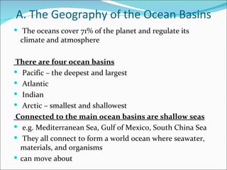
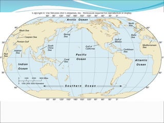
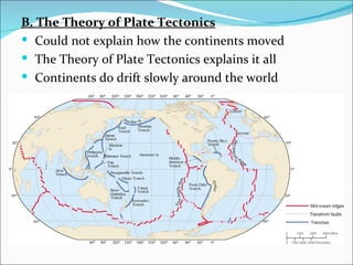
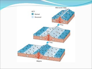
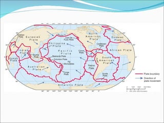
The Water Planet
A. The Geography of the Ocean Basins
 The oceans cover 71% of the planet and regulate its
  climate and atmosphere

There are four ocean basins
 Pacific – the deepest and largest
 Atlantic
 Indian
 Arctic – smallest and shallowest
Connected to the main ocean basins are shallow seas
 e.g. Mediterranean Sea, Gulf of Mexico, South China Sea
 They all connect to form a world ocean where seawater,
  materials, and organisms
 can move about
B. The Structure of the Earth
In the early molten Earth, lighter materials floated
   toward the surface
 They cooled to form the crust
 The atmosphere and oceans then formed
 Earth is the right distance from the sun for liquid water,
   and life, to exist
1. Internal Structure
 The dense core is mostly iron
 Solid inner core and liquid outer core
 The swirling motions produce the Earth’s magnetic field
 The mantle is outside the core and under the crust
 Near molten rock slowly flows like a liquid
 The crust is the outer layer, comparatively thin
 Like a skin floating on the mantle
2. Continental and Oceanic Crusts
 There are differences in the crust that make up sea floors
   and continents
a. Ocean crust
 Made of basalt – a dark mineral
 More dense
 Thinner
 Younger rock; 200 mil years
b. Continental crust
 Made of granite – lighter color
 Less dense
 Thicker
 Older rock; 3.8 bil years
 So continental crust floats high on the mantle and ocean
   crust floats lower
 That’s why ocean crust is covered by water
The Origin and Structure of the Ocean Basins
 The Earth is a world of constant transformation, where
  even the continents move
A. Early Evidence of Continental Drift
 400 years ago Sir Francis Bacon noted the continental
  coasts of the Atlantic fit
 together like pieces of a puzzle
 Later suggested the Americas might have been once
  joined to Europe and Africa
 Geologic formations and fossils matched from opposing
  sides
 Alfred Wegner gave hypothesis of Continental Drift in
  1912
 Suggested that all the continents had once been a
  supercontinent, named
 Pangea
 Started breaking up ~180 mil years ago
B. The Theory of Plate Tectonics
 Could not explain how the continents moved
 The Theory of Plate Tectonics explains it all
 Continents do drift slowly around the world
Discovery of the Mid-Ocean Ridge
 After WWII sonar allowed detailed maps of the
 sea floor
 They discovered the mid-ocean ridge system
 A chain of submarine volcanic mountains
 that encircle the globe, like seams on a
 baseball
 The largest geological feature on Earth
 Some of the mountains rise above sea level to form
  islands, e.g. Iceland
 The mid-Atlantic ridge runs down the center of the
  Atlantic Ocean and follows
 the curve of the opposing coastlines
 Sonar also discovered deep trenches
Significance of the Mid-Ocean Ridge
 Why are they there? How were they formed?
 Lots of seismic and volcanic activity around
 the ridges and trenches
 Rock near the ridge is young and gets older
 moving away from the ridge
 There is little sediment near the ridge, but it
 gets thicker moving away
 Found symmetric magnetic bands on either side of
 the ridge which alternate normal and reversed
 magnetism
Creation of the Sea Floor
 Huge pieces of oceanic crust are separating at the
 mid-ocean ridges
 Creating cracks called rifts
 Magma from the mantle rises through the rift
 forming the ridge
 The sea floor moves away from the ridge
 This continuous process is called sea-floor spreading
 New sea floor is created
 This explains why rocks are older and sediment is
  thicker as you move away from
 the ridge
 This also explains the magnetic stripes found in the
  sea floor
Sea-Floor Spreading and Plate Tectonics
 The crust and part of the upper mantle form the
 lithosphere
 100 km (60 mi) thick, rigid
 It’s broken into plates
 May be ocean crust, continent crust, or both
 The plates float on a fluid layer of the upper mantle called
  the asthenosphere.
 At mid-ocean ridges the plates move apart
 If the plate has continental crust it carries the continent
  with it
 Spread 2-18 cm/year
 This explains continental drift
 As new lithosphere is created, old lithosphere is destroyed
    somewhere else
    Some plate boundaries are trenches where one plate sinks
   below the other back down into the mantle and melts
    Called subduction
    Trenches are also called subduction zones
    The plates colliding can be ocean - continent
   ¨ Ocean plates always sinks below
   ¨ Produces earthquakes and volcanic mountain
   ranges; e.g. Sierra Nevada
    The plates colliding can be ocean - ocean
   ¨ Earthquakes and volcanic island arcs; e.g. Aleutian
   Islands
    The plates colliding can be cont - cont
   ¨ Neither plate sinks, instead they buckle
   ¨ Producing huge mountain ranges; e.g. Himalayas
A third boundary type
  is shear boundary
  or transform fault
 The plates slide past
  each other
 Causes earthquakes;
  e.g. San Andreas Fault
 Two forces move the
  plates
 Slab-Pull theory - the
  sinking plate pulls the
  rest behind it
 Convection theory –
  the swirling mantle
  moves the plate
C. Geologic History of the Earth
Continental Drift and the Changing Oceans
 200 mil years ago all the continents were joined in
  Pangea
 It was surrounded by a single ocean called
  Panthalassa
 180 mil years ago a rift formed splitting it into two
  large continents
 Laurasia – North America and Eurasia
 Gondwana – South America, Africa, Antarctica, India,
  and
 Australia
 The plates are still moving today
 Atlantic ocean is growing, Pacific is shrinking
The Record in the Sediments
  Two types of marine sediments:
 Lithogenous – from the weathering of rock on land
 Biogenous – from skeletons and shells of marine
  organisms
 ¨ Mostly composed of calcium carbonate or silica
 Microfossils tell what organisms lived and past ocean
  temperatures
 Climate and Changes in Sea Level
 The Earth alternates between interglacial (warm) period
  and ice age (cold) periods
 Sea level falls during ice ages because water is trapped in
  glaciers on the
 continents
The Geological Provinces of the Ocean
 Two main regions of the sea floor
 Continental margins – the submerged edge of the
  continents
 Deep-sea floor
A. Continental Margins
 Boundaries between the continental and ocean crust
 Consists of shelf, slope and rise
 The Continental Shelf
 The shallowest part
 Only 8% of the sea floor, but biologically rich
 and diverse
 Large submarine canyons can be found here
 Ends at the shelf break, where it steeply slopes down
 The Continental Slope
 The edge of the continent
 Slopes down from the shelf break to the deep-sea
    floor
   The Continental Rise
    Sediment accumulates on the sea floor at the base of
   the slope
   Active and Passive Margins
    Active margin – the subducting plate creates a trench
    Narrow shelf, steep slope, and little or no rise
    Steep, rocky shorelines
    Passive margin – no plate boundary
    Wide shelf, gradual slope, and thick rise
 Deep-Ocean Basins
 10,000-16,000 ft
 Abyssal plain - flat region of the sea floor
 Seamounts – submarine volcanoes
 Guyots – flat-topped seamounts
 Both were once islands, but now covered with water
 Trenches – the deepest part of the ocean
 Mariana Trench is 36,163 ft deep
 The Mid-Ocean Ridge and Hydrothermal Vents
 At the center of the ridge, where the plates pull apart, is
 a central rift valley
 Water seeps down through cracks, gets heated by the
 mantle, then emerges through hydrothermal vents
 350oC (660oF)
 Dissolved minerals from the mantle, like sulfides, are
 brought up
 Black smokers form when minerals solidify
 around a vent
 Marine life, including chemosynthesizers, exist
 around hydrothermal vents
The sea floor

The sea floor

  • 1.
  • 2.
    A. The Geographyof the Ocean Basins  The oceans cover 71% of the planet and regulate its climate and atmosphere There are four ocean basins  Pacific – the deepest and largest  Atlantic  Indian  Arctic – smallest and shallowest Connected to the main ocean basins are shallow seas  e.g. Mediterranean Sea, Gulf of Mexico, South China Sea  They all connect to form a world ocean where seawater, materials, and organisms  can move about
  • 4.
    B. The Structureof the Earth In the early molten Earth, lighter materials floated toward the surface  They cooled to form the crust  The atmosphere and oceans then formed  Earth is the right distance from the sun for liquid water, and life, to exist 1. Internal Structure  The dense core is mostly iron  Solid inner core and liquid outer core  The swirling motions produce the Earth’s magnetic field  The mantle is outside the core and under the crust  Near molten rock slowly flows like a liquid  The crust is the outer layer, comparatively thin  Like a skin floating on the mantle
  • 6.
    2. Continental andOceanic Crusts  There are differences in the crust that make up sea floors and continents a. Ocean crust  Made of basalt – a dark mineral  More dense  Thinner  Younger rock; 200 mil years b. Continental crust  Made of granite – lighter color  Less dense  Thicker  Older rock; 3.8 bil years  So continental crust floats high on the mantle and ocean crust floats lower  That’s why ocean crust is covered by water
  • 7.
    The Origin andStructure of the Ocean Basins  The Earth is a world of constant transformation, where even the continents move A. Early Evidence of Continental Drift  400 years ago Sir Francis Bacon noted the continental coasts of the Atlantic fit  together like pieces of a puzzle  Later suggested the Americas might have been once joined to Europe and Africa  Geologic formations and fossils matched from opposing sides  Alfred Wegner gave hypothesis of Continental Drift in 1912  Suggested that all the continents had once been a supercontinent, named  Pangea  Started breaking up ~180 mil years ago
  • 8.
    B. The Theoryof Plate Tectonics  Could not explain how the continents moved  The Theory of Plate Tectonics explains it all  Continents do drift slowly around the world
  • 9.
    Discovery of theMid-Ocean Ridge  After WWII sonar allowed detailed maps of the  sea floor  They discovered the mid-ocean ridge system  A chain of submarine volcanic mountains  that encircle the globe, like seams on a  baseball  The largest geological feature on Earth  Some of the mountains rise above sea level to form islands, e.g. Iceland  The mid-Atlantic ridge runs down the center of the Atlantic Ocean and follows  the curve of the opposing coastlines  Sonar also discovered deep trenches
  • 10.
    Significance of theMid-Ocean Ridge  Why are they there? How were they formed?  Lots of seismic and volcanic activity around  the ridges and trenches  Rock near the ridge is young and gets older  moving away from the ridge  There is little sediment near the ridge, but it  gets thicker moving away  Found symmetric magnetic bands on either side of  the ridge which alternate normal and reversed  magnetism
  • 12.
    Creation of theSea Floor  Huge pieces of oceanic crust are separating at the  mid-ocean ridges  Creating cracks called rifts  Magma from the mantle rises through the rift  forming the ridge  The sea floor moves away from the ridge  This continuous process is called sea-floor spreading  New sea floor is created  This explains why rocks are older and sediment is thicker as you move away from  the ridge  This also explains the magnetic stripes found in the sea floor
  • 14.
    Sea-Floor Spreading andPlate Tectonics  The crust and part of the upper mantle form the  lithosphere  100 km (60 mi) thick, rigid  It’s broken into plates  May be ocean crust, continent crust, or both  The plates float on a fluid layer of the upper mantle called the asthenosphere.  At mid-ocean ridges the plates move apart  If the plate has continental crust it carries the continent with it  Spread 2-18 cm/year  This explains continental drift
  • 16.
     As newlithosphere is created, old lithosphere is destroyed somewhere else  Some plate boundaries are trenches where one plate sinks  below the other back down into the mantle and melts  Called subduction  Trenches are also called subduction zones  The plates colliding can be ocean - continent  ¨ Ocean plates always sinks below  ¨ Produces earthquakes and volcanic mountain  ranges; e.g. Sierra Nevada  The plates colliding can be ocean - ocean  ¨ Earthquakes and volcanic island arcs; e.g. Aleutian  Islands  The plates colliding can be cont - cont  ¨ Neither plate sinks, instead they buckle  ¨ Producing huge mountain ranges; e.g. Himalayas
  • 18.
    A third boundarytype is shear boundary or transform fault  The plates slide past each other  Causes earthquakes; e.g. San Andreas Fault  Two forces move the plates  Slab-Pull theory - the sinking plate pulls the rest behind it  Convection theory – the swirling mantle moves the plate
  • 20.
    C. Geologic Historyof the Earth Continental Drift and the Changing Oceans  200 mil years ago all the continents were joined in Pangea  It was surrounded by a single ocean called Panthalassa  180 mil years ago a rift formed splitting it into two large continents  Laurasia – North America and Eurasia  Gondwana – South America, Africa, Antarctica, India, and  Australia  The plates are still moving today  Atlantic ocean is growing, Pacific is shrinking
  • 22.
    The Record inthe Sediments Two types of marine sediments:  Lithogenous – from the weathering of rock on land  Biogenous – from skeletons and shells of marine organisms  ¨ Mostly composed of calcium carbonate or silica  Microfossils tell what organisms lived and past ocean temperatures  Climate and Changes in Sea Level  The Earth alternates between interglacial (warm) period and ice age (cold) periods  Sea level falls during ice ages because water is trapped in glaciers on the  continents
  • 23.
    The Geological Provincesof the Ocean  Two main regions of the sea floor  Continental margins – the submerged edge of the continents  Deep-sea floor A. Continental Margins  Boundaries between the continental and ocean crust  Consists of shelf, slope and rise  The Continental Shelf  The shallowest part  Only 8% of the sea floor, but biologically rich  and diverse  Large submarine canyons can be found here  Ends at the shelf break, where it steeply slopes down
  • 25.
     The ContinentalSlope  The edge of the continent  Slopes down from the shelf break to the deep-sea floor  The Continental Rise  Sediment accumulates on the sea floor at the base of  the slope  Active and Passive Margins  Active margin – the subducting plate creates a trench  Narrow shelf, steep slope, and little or no rise  Steep, rocky shorelines  Passive margin – no plate boundary  Wide shelf, gradual slope, and thick rise
  • 27.
     Deep-Ocean Basins 10,000-16,000 ft  Abyssal plain - flat region of the sea floor  Seamounts – submarine volcanoes  Guyots – flat-topped seamounts  Both were once islands, but now covered with water  Trenches – the deepest part of the ocean  Mariana Trench is 36,163 ft deep
  • 28.
     The Mid-OceanRidge and Hydrothermal Vents  At the center of the ridge, where the plates pull apart, is  a central rift valley  Water seeps down through cracks, gets heated by the  mantle, then emerges through hydrothermal vents  350oC (660oF)  Dissolved minerals from the mantle, like sulfides, are  brought up  Black smokers form when minerals solidify  around a vent  Marine life, including chemosynthesizers, exist  around hydrothermal vents