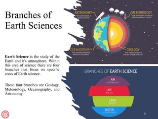
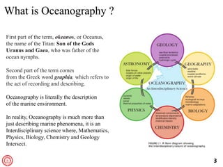
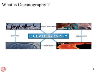
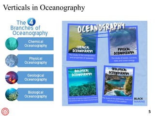
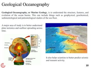
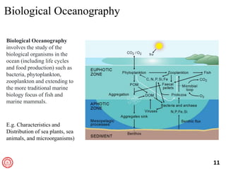
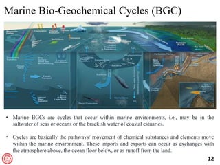
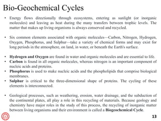
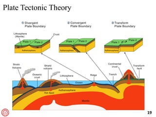
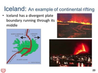
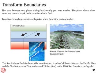
Dr. Samiran Mandal
Centre for Atmospheric Sciences
Indian Institute of Technology Delhi
Introduction to Oceanography
ASL350
Module 2
Branches of
Earth Sciences
Earth Science is the study of the
Earth and it's atmosphere. Within
this area of science there are four
branches that focus on specific
areas of Earth science.
These four branches are Geology,
Meteorology, Oceanography, and
Astronomy.
2
3
What is Oceanography ?
First part of the term, okeanos, or Oceanus,
the name of the Titan: Son of the Gods
Uranus and Gaea, who was father of the
ocean nymphs.
Second part of the term comes
from the Greek word graphia, which refers to
the act of recording and describing.
Oceanography is literally the description
of the marine environment.
In reality, Oceanography is much more than
just describing marine phenomena, it is an
Interdisciplinary science where, Mathematics,
Physics, Biology, Chemistry and Geology
Intersect.
4
What is Oceanography ?
5
Verticals in Oceanography
6
Chemical Oceanography
Chemical Oceanography is the study of the
composition of seawater, chemical
interactions within ocean ecosystems and the
biogeochemical cycles that affect it, inclusive
of both man-made and natural chemicals.
Understanding Chemical Oceanography
helps us to understand Ocean Acidification,
Hypoxia, determine how anthropogenic
activity such as runoff and pollution impacts
our oceans.
Chemical Oceanographers use instruments
such as pH sensors, electrical conductivity
sensors, and dissolved CO2 sensors to
measure how fast chemicals will assimilate
into the water.
7
8
Physical Oceanography
Physical Oceanography is the study of the physical conditions and processes of the ocean
involves the study of the properties (Temperature, Salinity, Density, etc.) and movement
(Waves, Currents, and Tides) of seawater and the interaction between the Ocean and
Atmosphere.
The study of genesis and
characteristics of various
types of motions of
seawater such as sea
waves, ocean currents,
tides, tsunamis, and tidal
and storm surges.
9
Physical Oceanography
https://youtu.be/5FNHtNEshk8
10
Geological Oceanography
Geological Oceanography, or Marine Geology, is to understand the structure, features, and
evolution of the ocean basins. This can include things such as geophysical, geochemical,
sedimentological and paleontological studies of the sea floor.
A major area of study is to better understand
plate tectonics and seafloor spreading across
time.
It also helps scientists to better predict seismic
and tsunami activity.
11
Biological Oceanography
involves the study of the
biological organisms in the
ocean (including life cycles
and food production) such as
bacteria, phytoplankton,
zooplankton and extending to
the more traditional marine
biology focus of fish and
marine mammals.
E.g. Characteristics and
Distribution of sea plants, sea
animals, and microorganisms)
12
Marine Bio-Geochemical Cycles (BGC)
• Marine BGCs are cycles that occur within marine environments, i.e., may be in the
saltwater of seas or oceans or the brackish water of coastal estuaries.
• Cycles are basically the pathways/ movement of chemical substances and elements move
within the marine environment. These imports and exports can occur as exchanges with
the atmosphere above, the ocean floor below, or as runoff from the land.
13
Bio-Geochemical Cycles
• Energy flows directionally through ecosystems, entering as sunlight (or inorganic
molecules) and leaving as heat during the many transfers between trophic levels. The
matter that makes up living organisms is always conserved and recycled.
• Six common elements associated with organic molecules—Carbon, Nitrogen, Hydrogen,
Oxygen, Phosphorus, and Sulphur—take a variety of chemical forms and may exist for
long periods in the atmosphere, on land, in water, or beneath the Earth's surface.
• Hydrogen and Oxygen are found in water and organic molecules and are essential to life.
• Carbon is found in all organic molecules, whereas nitrogen is an important component of
nucleic acids and proteins.
• Phosphorus is used to make nucleic acids and the phospholipids that comprise biological
membranes.
• Sulphur is critical to the three-dimensional shape of proteins. The cycling of these
elements is interconnected.
• Geological processes, such as weathering, erosion, water drainage, and the subduction of
the continental plates, all play a role in this recycling of materials. Because geology and
chemistry have major roles in the study of this process, the recycling of inorganic matter
between living organisms and their environment is called a Biogeochemical Cycle.
14
Interrelation
15
In-a-Nutshell
• Oceanography is greater than the sum of these specific branches.
• Oceanographers use a variety of tools/ instruments to study the ocean, and many of these
studies are interdisciplinary. Oceanographers collect discrete water, sediment and
biological samples using ships (Research Vessels). They deploy autonomous sampling
systems such as buoys and gliders to collect data over time and space scales that cannot
be done with a ship.
• Remote Sensing from aircraft and satellites allows oceanographers to get a global view of
some parameters.
• Modeling allows oceanographers to look at the past and predict the future state of the
ocean (e.g circulation, air-sea interactions, sustainability of fisheries, quality of water, etc.).
16
Why Ocean Basins ?
Ocean covers about 71% of the Earth, and the rest 29% is Dry Land.
17
History of Earth
Pangaea existed nearly 200 million
years ago, which began to move
and divide into seven continents
following the tectonic processes.
Two large landmasses:
1. Laurasia, which is roughly the
Northern Hemisphere.
Laurasia=North America + Eurasia.
2. Gondwanaland, which is the
Southern Hemisphere.
Gondwanaland=Africa + Antarctica
+ Australia + South America
18
Continental Drift: Continents are Moving !!
The Theory was proposed by Alfred Wegner in 1912.
19
Plate Tectonic Theory
20
The Crusts
21
Divergent Boundaries
Divergent boundaries occur along spreading centers where plates are moving apart,
and new crust is created by magma pushing up from the mantle.
Two giant conveyor belts, facing each other but slowly moving in opposite directions
as they transport newly formed oceanic crust away from the ridge crest.
22
23
24
Convergent Boundaries
There are three styles of convergent plate
boundaries,
• Continent-Continent Collision
• Continent-Oceanic Crust Collision
• Ocean-Ocean Collision
25
Continent-Continent Collision
26
Continent-Continent Collision
• The Himalayan mountain range dramatically demonstrates one of the most visible and
spectacular consequences of plate tectonics.
• When two continents meet head-on, neither is subducted because the continental rocks
are relatively light and, like two colliding icebergs, resist downward motion.
• Instead, the crust tends to buckle and be pushed upward or sideways.
• The collision of India into Asia 50 million years ago caused the Indian and Eurasian
Plates to crumple up along the collision zone.
• After the collision, the slow continuous convergence of these two plates over millions
of years pushed up the Himalayas and the Tibetan Plateau to their present heights.
• Most of this growth occurred during the past 10 million years. The Himalayas,
towering as high as 8,854 m above sea level, form the highest continental mountains in
the world.
27
Deep Ocean Trenches are formed during a process known as Subduction.
In subduction, one tectonic plate (a large portion of the Earth's crust) slides under
another. The plate that is slipping under the other plate bends and forms an ocean trench.
Continent-Oceanic Crust Collision
28
Subduction Zones
• The definition of subduction is the
process that occurs when two
tectonic plates meet at convergent
boundaries, and one of the plates
moves under the other one due to
gravity and differences in density.
The boundary area where this occurs
is the subduction zone.
• For Peru-Chile and Washington’s
Coast, an oceanic plate is moving
forward and has slide under the
continental plate off the west coast
is a best example of convergent
subduction.
29
30
31
Ocean-Ocean Plate Collision
When two oceanic plates collide, one runs over the other, which causes it to sink into the
mantle forming a Subduction Zone.
The subducting plate is bent downwards to form a very deep depression in the ocean floor
called a Trench.
32
Ocean-Ocean Plate Collision
One of classic examples is, The Marianas Trench, where the fast-moving Pacific Plate
converges against the slower moving Philippine Plate.
The Challenger Deep, at the southern end of the Marianas Trench, plunges deeper into the
Earth's interior (nearly 11,000 m) than Mount Everest, the world's tallest mountain, rises above
sea level (about 8,854 m).
33
The zone between two plates sliding horizontally past one another. The place where plates
move and cause a break in the crust is called a fault.
Transform boundaries create earthquakes when they slide past each other.
Transform Boundaries
The San Andreas Fault is the world's most famous; it splits California between the Pacific Plate
and the North American Plate and moved 20 feet (6 m) in the 1906 San Francisco earthquake.
34
Plate Tectonics
https://pubs.usgs.gov/gip/dynamic/understanding.html
35
Pangaea: Continental Drift
36
Ocean Basins
Ocean covers about 71% of the Earth, and the rest 29% is Dry Land.
37
Questions??

2_Intro_Oceanography.pptx

  • 1.
    Dr. Samiran Mandal Centrefor Atmospheric Sciences Indian Institute of Technology Delhi Introduction to Oceanography ASL350 Module 2
  • 2.
    Branches of Earth Sciences EarthScience is the study of the Earth and it's atmosphere. Within this area of science there are four branches that focus on specific areas of Earth science. These four branches are Geology, Meteorology, Oceanography, and Astronomy. 2
  • 3.
    3 What is Oceanography? First part of the term, okeanos, or Oceanus, the name of the Titan: Son of the Gods Uranus and Gaea, who was father of the ocean nymphs. Second part of the term comes from the Greek word graphia, which refers to the act of recording and describing. Oceanography is literally the description of the marine environment. In reality, Oceanography is much more than just describing marine phenomena, it is an Interdisciplinary science where, Mathematics, Physics, Biology, Chemistry and Geology Intersect.
  • 4.
  • 5.
  • 6.
    6 Chemical Oceanography Chemical Oceanographyis the study of the composition of seawater, chemical interactions within ocean ecosystems and the biogeochemical cycles that affect it, inclusive of both man-made and natural chemicals. Understanding Chemical Oceanography helps us to understand Ocean Acidification, Hypoxia, determine how anthropogenic activity such as runoff and pollution impacts our oceans. Chemical Oceanographers use instruments such as pH sensors, electrical conductivity sensors, and dissolved CO2 sensors to measure how fast chemicals will assimilate into the water.
  • 7.
  • 8.
    8 Physical Oceanography Physical Oceanographyis the study of the physical conditions and processes of the ocean involves the study of the properties (Temperature, Salinity, Density, etc.) and movement (Waves, Currents, and Tides) of seawater and the interaction between the Ocean and Atmosphere. The study of genesis and characteristics of various types of motions of seawater such as sea waves, ocean currents, tides, tsunamis, and tidal and storm surges.
  • 9.
  • 10.
    10 Geological Oceanography Geological Oceanography,or Marine Geology, is to understand the structure, features, and evolution of the ocean basins. This can include things such as geophysical, geochemical, sedimentological and paleontological studies of the sea floor. A major area of study is to better understand plate tectonics and seafloor spreading across time. It also helps scientists to better predict seismic and tsunami activity.
  • 11.
    11 Biological Oceanography Biological Oceanography involvesthe study of the biological organisms in the ocean (including life cycles and food production) such as bacteria, phytoplankton, zooplankton and extending to the more traditional marine biology focus of fish and marine mammals. E.g. Characteristics and Distribution of sea plants, sea animals, and microorganisms)
  • 12.
    12 Marine Bio-Geochemical Cycles(BGC) • Marine BGCs are cycles that occur within marine environments, i.e., may be in the saltwater of seas or oceans or the brackish water of coastal estuaries. • Cycles are basically the pathways/ movement of chemical substances and elements move within the marine environment. These imports and exports can occur as exchanges with the atmosphere above, the ocean floor below, or as runoff from the land.
  • 13.
    13 Bio-Geochemical Cycles • Energyflows directionally through ecosystems, entering as sunlight (or inorganic molecules) and leaving as heat during the many transfers between trophic levels. The matter that makes up living organisms is always conserved and recycled. • Six common elements associated with organic molecules—Carbon, Nitrogen, Hydrogen, Oxygen, Phosphorus, and Sulphur—take a variety of chemical forms and may exist for long periods in the atmosphere, on land, in water, or beneath the Earth's surface. • Hydrogen and Oxygen are found in water and organic molecules and are essential to life. • Carbon is found in all organic molecules, whereas nitrogen is an important component of nucleic acids and proteins. • Phosphorus is used to make nucleic acids and the phospholipids that comprise biological membranes. • Sulphur is critical to the three-dimensional shape of proteins. The cycling of these elements is interconnected. • Geological processes, such as weathering, erosion, water drainage, and the subduction of the continental plates, all play a role in this recycling of materials. Because geology and chemistry have major roles in the study of this process, the recycling of inorganic matter between living organisms and their environment is called a Biogeochemical Cycle.
  • 14.
  • 15.
    15 In-a-Nutshell • Oceanography isgreater than the sum of these specific branches. • Oceanographers use a variety of tools/ instruments to study the ocean, and many of these studies are interdisciplinary. Oceanographers collect discrete water, sediment and biological samples using ships (Research Vessels). They deploy autonomous sampling systems such as buoys and gliders to collect data over time and space scales that cannot be done with a ship. • Remote Sensing from aircraft and satellites allows oceanographers to get a global view of some parameters. • Modeling allows oceanographers to look at the past and predict the future state of the ocean (e.g circulation, air-sea interactions, sustainability of fisheries, quality of water, etc.).
  • 16.
    16 Why Ocean Basins? Ocean covers about 71% of the Earth, and the rest 29% is Dry Land.
  • 17.
    17 History of Earth Pangaeaexisted nearly 200 million years ago, which began to move and divide into seven continents following the tectonic processes. Two large landmasses: 1. Laurasia, which is roughly the Northern Hemisphere. Laurasia=North America + Eurasia. 2. Gondwanaland, which is the Southern Hemisphere. Gondwanaland=Africa + Antarctica + Australia + South America
  • 18.
    18 Continental Drift: Continentsare Moving !! The Theory was proposed by Alfred Wegner in 1912.
  • 19.
  • 20.
  • 21.
    21 Divergent Boundaries Divergent boundariesoccur along spreading centers where plates are moving apart, and new crust is created by magma pushing up from the mantle. Two giant conveyor belts, facing each other but slowly moving in opposite directions as they transport newly formed oceanic crust away from the ridge crest.
  • 22.
  • 23.
  • 24.
    24 Convergent Boundaries There arethree styles of convergent plate boundaries, • Continent-Continent Collision • Continent-Oceanic Crust Collision • Ocean-Ocean Collision
  • 25.
  • 26.
    26 Continent-Continent Collision • TheHimalayan mountain range dramatically demonstrates one of the most visible and spectacular consequences of plate tectonics. • When two continents meet head-on, neither is subducted because the continental rocks are relatively light and, like two colliding icebergs, resist downward motion. • Instead, the crust tends to buckle and be pushed upward or sideways. • The collision of India into Asia 50 million years ago caused the Indian and Eurasian Plates to crumple up along the collision zone. • After the collision, the slow continuous convergence of these two plates over millions of years pushed up the Himalayas and the Tibetan Plateau to their present heights. • Most of this growth occurred during the past 10 million years. The Himalayas, towering as high as 8,854 m above sea level, form the highest continental mountains in the world.
  • 27.
    27 Deep Ocean Trenchesare formed during a process known as Subduction. In subduction, one tectonic plate (a large portion of the Earth's crust) slides under another. The plate that is slipping under the other plate bends and forms an ocean trench. Continent-Oceanic Crust Collision
  • 28.
  • 29.
    Subduction Zones • Thedefinition of subduction is the process that occurs when two tectonic plates meet at convergent boundaries, and one of the plates moves under the other one due to gravity and differences in density. The boundary area where this occurs is the subduction zone. • For Peru-Chile and Washington’s Coast, an oceanic plate is moving forward and has slide under the continental plate off the west coast is a best example of convergent subduction. 29
  • 30.
  • 31.
    31 Ocean-Ocean Plate Collision Whentwo oceanic plates collide, one runs over the other, which causes it to sink into the mantle forming a Subduction Zone. The subducting plate is bent downwards to form a very deep depression in the ocean floor called a Trench.
  • 32.
    32 Ocean-Ocean Plate Collision Oneof classic examples is, The Marianas Trench, where the fast-moving Pacific Plate converges against the slower moving Philippine Plate. The Challenger Deep, at the southern end of the Marianas Trench, plunges deeper into the Earth's interior (nearly 11,000 m) than Mount Everest, the world's tallest mountain, rises above sea level (about 8,854 m).
  • 33.
    33 The zone betweentwo plates sliding horizontally past one another. The place where plates move and cause a break in the crust is called a fault. Transform boundaries create earthquakes when they slide past each other. Transform Boundaries The San Andreas Fault is the world's most famous; it splits California between the Pacific Plate and the North American Plate and moved 20 feet (6 m) in the 1906 San Francisco earthquake.
  • 34.
  • 35.
  • 36.
    36 Ocean Basins Ocean coversabout 71% of the Earth, and the rest 29% is Dry Land.
  • 37.