Marine Provinces and Ocean floor: Features and Processes.pptx
This presentation explores the structure and classification of marine provinces, including continental margins, deep-ocean basins, and mid-ocean ridges. It also discusses oceanic processes and geological formations found on the seafloor.
What Techniques AreUsed to
Determine Ocean Bathymetry?
• Bathymetry (bathos = depth, metry =
measurement) is the measurement of ocean
depths and the charting of the shape, or
topography(topos = place, graphy =description
of) of the ocean floor.
• measuring the vertical distance from the ocean
surface down to the mountains, valleys, and
plains of the sea floor.
• The first recorded attempt to measure the
ocean’s depth was conducted in the
Mediterranean Sea in about 85 B.C. by a Greek
named Posidonius.
• The standard unit of ocean depth is the
fathom, which is equal to 1.8 meters (6 feet).
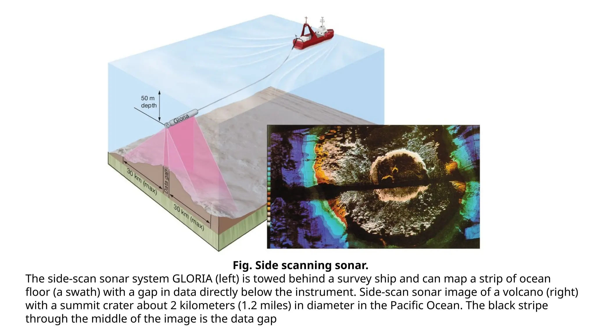
• Echo soundings: used to depict the relief
features of the ocean floor
• Multibeam echo sounders and side scan
sonar: use sound to map the ocean floor
• Side scan sonar used in deep water condition
Fig. Side scanningsonar.
The side-scan sonar system GLORIA (left) is towed behind a survey ship and can map a strip of ocean
floor (a swath) with a gap in data directly below the instrument. Side-scan sonar image of a volcano (right)
with a summit crater about 2 kilometers (1.2 miles) in diameter in the Pacific Ocean. The black stripe
through the middle of the image is the data gap
6.
15/02/2025 Sample FooterText 6
Fig. Satellite measurements of the ocean
surface.
Fig. Seismic Profiling
7.
15/02/2025 Sample FooterText 7
Fig. Earth’s hypsographic curve. The bar graph gives the percentage
of Earth’s surface area at various ranges of elevation and depth
8.
What Features
exist oncontinental
margin?
The Ocean floor can be
divided into three marine
Provinces.
1. Continental margins
2. Deep ocean basins
3. Mid Oceanic Ridges
9.
Continental
Margins
• Zones separatingthe part
of a continent above sea
level from the deep-sea
floor.
• The true geologic margin
of a continent – where
continental crust changes
to oceanic crust – is
somewhere beneath the
continental slope.
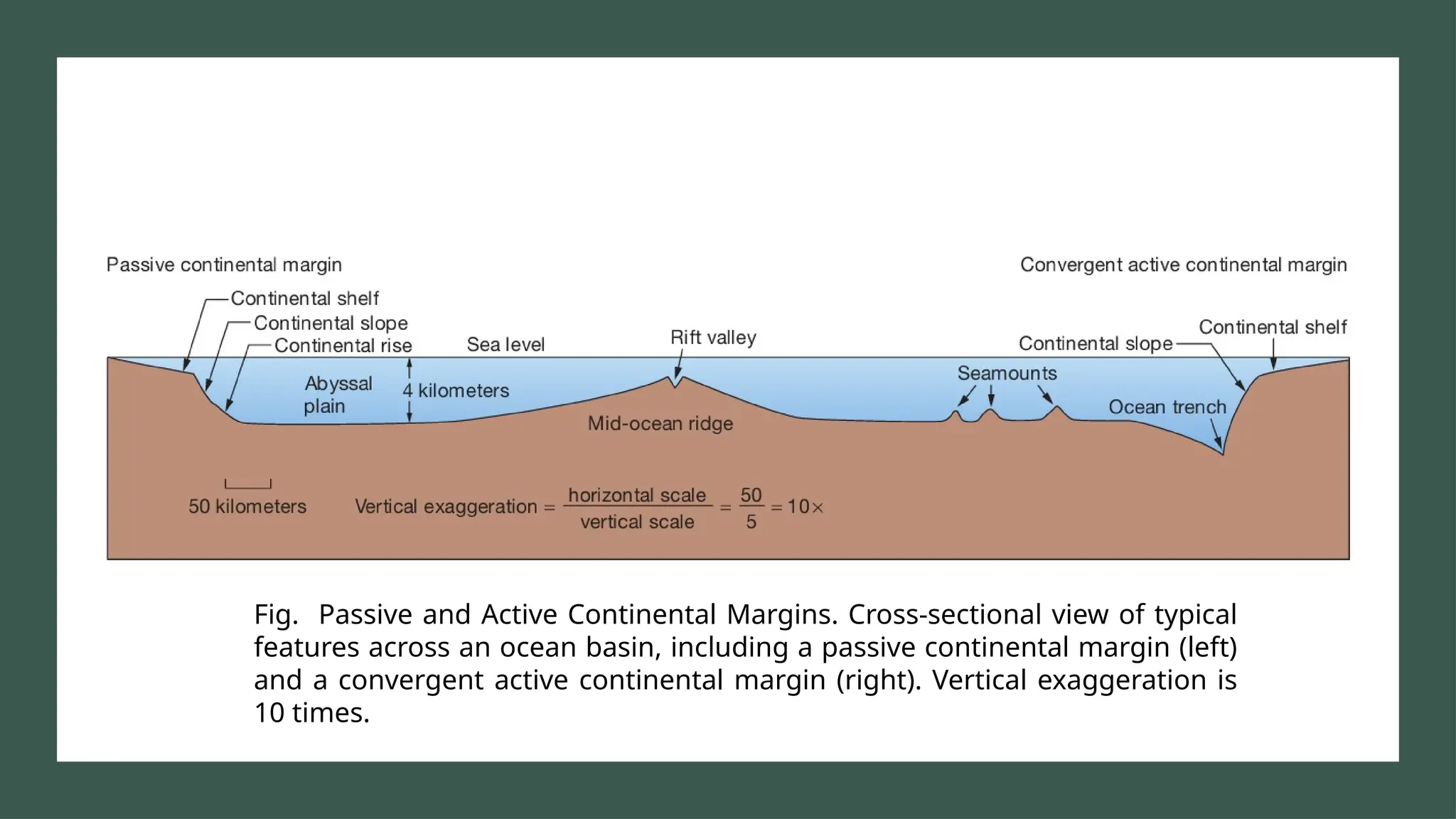
Fig. Passive andActive Continental Margins. Cross-sectional view of typical
features across an ocean basin, including a passive continental margin (left)
and a convergent active continental margin (right). Vertical exaggeration is
10 times.
12.
Passive
Versus
Active
Continental
Margins
Sample Footer Text02/15/2025 12
Passive Active
Embedded within the interior of
lithospheric plates
Associated with lithospheric plate
boundaries
Not proximity to any plate
boundary
Marked by high tectonic activity
Lack of major tectonic activity viz,
earthquake, eruptive volcanoes
and mountain building
Convergent active margins are
associated with oceanic-
continental convergent plate
boundaries.
Ex- Nazca plate subducted
beneath the South American
plate
Ex- East Coast of United States Transform active margins are less
common and are associated with
transform plate boundaries.
Ex- Coastal California along the
San Andreas Fault
Continental
Shelf
• Flat zoneextending from the shore beneath the
ocean surface to a point at which a marked
increase in slope angle occurs, called the Shelf
break.
• Relatively featureless but can contain coastal
island, coral reefs, raised banks
• Avg. width 70 km, varies from a few tens'
meters to 1500 kms.
• The broadest shelves occur off the northern
coasts of Siberia and North America in Arctic
Ocean
• The average depth at which the shelf break
occurs is about 135 meters
• In the Pleistocene, sea level was much lower, at
130m.
• Some Glaciers extended onto the exposed
shelves.
• Affected by waves and tidal currents.
16.
Continental
Slope
• Change ingradient from shelf
• Average gradient 4 degree. (but
varies from 1 to 25 degrees)
• Submarine canyons cut into
slope by turbidity currents
USA
Margin of Pacific
Ocean
Atlantic & Indian
Ocean
2̊ 5̊ 3 ̊
18.
Continental rise
• Gentlysloping area from the slope to a trench
• Unaffected by surface processes and transport
is controlled by gravity. Where most of the
sediments are eventually deposited. Much of
the sediment is transported by turbidity
currents.
• Deep ocean basin – seaward of the continental
margin.
• Transition between continental crust and
oceanic crust
• Turbidite deposits
1. Graded bedding
2. Submarine Fans
Fig. Map of Indus Fan. (Passive margin fan)
19.
Turbidity Currents
• TurbidityCurrents: Sediment–water mixture denser than normal seawater
• Flow downslope to the deep sea floor
• Coarsest particles are deposited first – forming a graded bed.
• Deposits accumulate as a series of overlapping submarine fans, forming a large
part of the continental rise.
• Turbidity currents are underwater avalanches of muddy water mixed with
sediment that move down the continental slope and are responsible for
carving submarine canyons.
20.
Submarine
Canyons
• Deep, steep-sidedsubmarine
canyons occur on continental
shelves but are best developed on
continental slopes.
• Some canyons can be traced
across the shelf to associated
streams on land. Some can not.
• Strong currents move through
these canyons and are probably
responsible for erosion.
22.
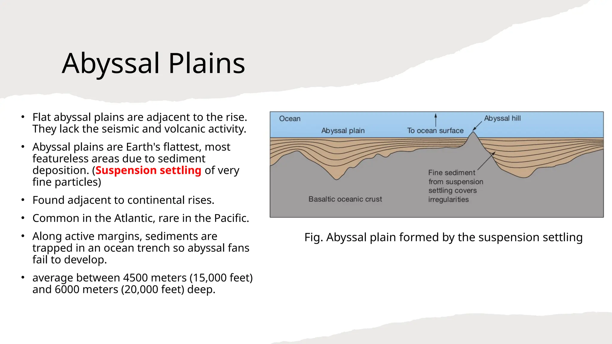
Abyssal Plains
• Flatabyssal plains are adjacent to the rise.
They lack the seismic and volcanic activity.
• Abyssal plains are Earth's flattest, most
featureless areas due to sediment
deposition. (Suspension settling of very
fine particles)
• Found adjacent to continental rises.
• Common in the Atlantic, rare in the Pacific.
• Along active margins, sediments are
trapped in an ocean trench so abyssal fans
fail to develop.
• average between 4500 meters (15,000 feet)
and 6000 meters (20,000 feet) deep.
Fig. Abyssal plain formed by the suspension settling
23.
Volcanic Peaks of
theAbyssal Plains
• Sea mounts: that are below sea level but rise
more than 1 kilometer (0.6 miles) above the
deep-ocean floor and have a pointy top like an
upside-down ice cream cone
• Worldwide, there are more than 50,000 known
seamounts
• Table mount / guyot: if a volcano has a
flattened top
• the minimum height of a seamount is called an
abyssal hill, or sea knoll
• Abyssal hills – average at 250m high
• They are common on the sea floor and underlie
thick sediments on the abyssal plains.
24.
Oceanic
trenches
• Where lithosphericplates are
consumed by subduction.
• Long, narrow features restricted
to active continental margins.
• Oceanic trenches are the sites
of the greatest oceanic depth.
• Mariana trench: 11,000 m deep
• The crust here is cooler and
slightly denser than elsewhere.
25.
Fig. Majority ofocean trenches are along the margins of the Pacific Ocean where plates
are being subducted.
27.
Fig. Floor ofthe North Atlantic Ocean (Mid-Atlantic
Ridge)
28.
Mid –
oceanic
ridge
Longest mountainchain
On average, 2.5 km (1.5 miles) above surrounding sea
floor
Wholly volcanic
Basaltic lava
Divergent plate boundary
Centra lift valley, faults, and fissures
Seamounts
Pillow basalts
Hydrothermal vents – Deposits of metal sulfides
Fracture zones and transform faults
29.
Mid-Ocean
ridge features
1. Oceanicridge
• Prominent rift valley
• Steep, rugged slopes
• Example: MOR
2. Oceanic rise
• Gentler, less rugged slopes
• Examples: East Pacific Rise
30.
Volcanic Features
Pillow lava/ Pillow basalt
• When lava flows enter the ocean, or when lava
outpourings actually originate within an ocean
basin, the flows outer zones quickly congeal.
• The lava within the flow is able to move forward
by breaking through the hardened surface, when
this occurs over and over.
• The lava flow resembles large bed pillows
stacked one upon another.
31.
Hydro-thermal Vents
• Hydro- water, thermo -heat
• Heated subsurface seawater migrates through cracks in the ocean crust
• Hydrothermal vents are seafloor hot springs created when cold seawater seeps down along cracks
and fractures in the ocean crust and approaches an underground magma chamber.
• The temperature of the water that rushes out of a particular hydrothermal vent determines its
appearance:
1. Warm-water vents have water temperatures below 30°C (86°F) and generally emit water
that is clear in color.
2. White smokers have water temperatures from 30° to 350°C (86° to 662°F) and emit water
that is white because of the presence of various light-colored compounds, including barium sulfide.
3. Black smokers have water temperatures above 350°C (662°F) and emit water that is black
because of the presence of dark-colored metal sulfides, including iron, nickel, copper, and zinc
32.
Fig. Diagram showinghydrothermal circu lation along the mid-ocean ridge and the creation of
black smokers
Fig. Transform faultsand fracture zones. (Transform faults are active transform plate
boundaries that occur between the segments of the mid-ocean ridge. Fracture zones are
inactive intraplate features that occur beyond the segments of the mid-ocean ridge.)