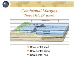
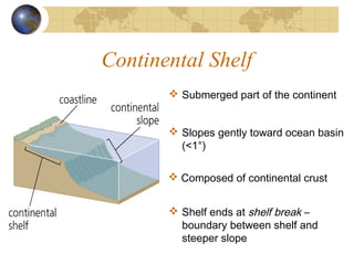
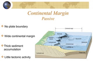
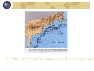
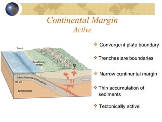
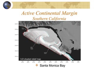
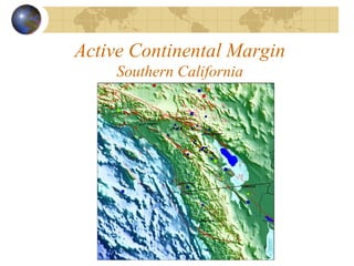
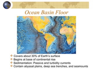
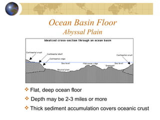
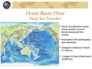
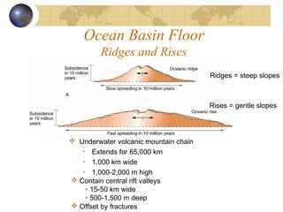
Continental Margins
and
Ocean Basins
Continental Margins
Three Main Divisions
 Continental shelf
 Continental slope
 Continental rise
Continental Shelf
 Submerged part of the continent
 Slopes gently toward ocean basin
(<1°)
 Composed of continental crust
 Shelf ends at shelf break –
boundary between shelf and
steeper slope
Continental Slope
 Boundary between continental
and oceanic crust
 Steeply sloping compared to shelf
(5-25°)
Submarine canyons are major
features
 Extends from shelf break to rise
Submarine Canyon
 Origin of submarine canyons:
• river erosion
• turbidity currents
Submarine Canyon
Turbidity Currents
 Turbidites are layered and exhibit graded bedding (decrease in
sediment grain size from bottom to top)
 Downslope movement of dense mixture of clay, silt, sand and water
 Deposits are called turbidites
Continental Rise
 At base of continental slope
 Slope angle decreases
 Caused by the accumulation of sediment
Continental Margins
Types
 Passive Margin Active Margin
Continental Margin
Passive
 No plate boundary
 Little tectonic activity
Thick sediment
accumulation
 Wide continental margin
• http://oceanexplorer.noaa.gov/okeanos/exploratio
Continental Margin
Active
 Convergent plate boundary
Trenches are boundaries
 Tectonically active
Thin accumulation of
sediments
 Narrow continental margin
Continental Margin
Passive vs. Active
 Passive Margins
• Major rivers drain into ocean
• Sediment transported by
river builds out shelf
 Active Margins
• Large rivers uncommon
• Irregular shelves
Active Continental Margin
Southern California
 Santa Monica Bay
3-D shaded relief map
Active Continental Margin
Southern California
Ocean Basin Floor
Features
 Seamounts and Guyots
 Coral Reefs and Atolls
 Ridges and Rises
 Abyssal Plain
 Trenches
Ocean Basin Floor
 Covers about 30% of Earth’s surface
 Contain abyssal plains, deep sea trenches, and seamounts
 Begins at base of continental rise
 Sedimentation: Passive and turbidity currents
Ocean Basin Floor
Abyssal Plain
 Flat, deep ocean floor
 Depth may be 2-3 miles or more
 Thick sediment accumulation covers oceanic crust
Ocean Basin Floor
Deep Sea Trenches
Occur at subduction zones
where oceanic crust is
forced downward into
mantle
Associated with earthquakes
and volcanoes
 Deepest is Mariana Trench
(11,020 m)
 Longest is Peru-Chile trench
(5,900 km)
Ocean Basin Floor
Ridges and Rises
 Contain central rift valleys
• 15-50 km wide
• 500-1,500 m deep
 Offset by fractures
 Underwater volcanic mountain chain
• Extends for 65,000 km
• 1,000 km wide
• 1,000-2,000 m high
Ridges = steep slopes
Rises = gentle slopes
Ocean Basin FloorOcean Basin Floor
Seamounts and GuyotsSeamounts and Guyots
 Seamounts are underwater volcanoes formed along
ocean ridges or over hot spots
 May be eroded flat on top and called Guyots
 May emerge as an island
Ocean Basin Floor
Coral Reefs and Atolls
 Volcanic islands (from seamount) form in warm latitudes
 Fringing coral reefs form in shallow, sunlit waters
 Dormant volcano subsides and flattens (becomes a guyot)
 Actively-growing reef becomes a barrier reef and then an atoll

Continental margins

  • 1.
  • 2.
    Continental Margins Three MainDivisions  Continental shelf  Continental slope  Continental rise
  • 3.
    Continental Shelf  Submergedpart of the continent  Slopes gently toward ocean basin (<1°)  Composed of continental crust  Shelf ends at shelf break – boundary between shelf and steeper slope
  • 4.
    Continental Slope  Boundarybetween continental and oceanic crust  Steeply sloping compared to shelf (5-25°) Submarine canyons are major features  Extends from shelf break to rise
  • 5.
    Submarine Canyon  Originof submarine canyons: • river erosion • turbidity currents
  • 6.
    Submarine Canyon Turbidity Currents Turbidites are layered and exhibit graded bedding (decrease in sediment grain size from bottom to top)  Downslope movement of dense mixture of clay, silt, sand and water  Deposits are called turbidites
  • 7.
    Continental Rise  Atbase of continental slope  Slope angle decreases  Caused by the accumulation of sediment
  • 8.
  • 9.
    Continental Margin Passive  Noplate boundary  Little tectonic activity Thick sediment accumulation  Wide continental margin
  • 10.
  • 11.
    Continental Margin Active  Convergentplate boundary Trenches are boundaries  Tectonically active Thin accumulation of sediments  Narrow continental margin
  • 12.
    Continental Margin Passive vs.Active  Passive Margins • Major rivers drain into ocean • Sediment transported by river builds out shelf  Active Margins • Large rivers uncommon • Irregular shelves
  • 13.
    Active Continental Margin SouthernCalifornia  Santa Monica Bay 3-D shaded relief map
  • 14.
  • 15.
    Ocean Basin Floor Features Seamounts and Guyots  Coral Reefs and Atolls  Ridges and Rises  Abyssal Plain  Trenches
  • 16.
    Ocean Basin Floor Covers about 30% of Earth’s surface  Contain abyssal plains, deep sea trenches, and seamounts  Begins at base of continental rise  Sedimentation: Passive and turbidity currents
  • 17.
    Ocean Basin Floor AbyssalPlain  Flat, deep ocean floor  Depth may be 2-3 miles or more  Thick sediment accumulation covers oceanic crust
  • 18.
    Ocean Basin Floor DeepSea Trenches Occur at subduction zones where oceanic crust is forced downward into mantle Associated with earthquakes and volcanoes  Deepest is Mariana Trench (11,020 m)  Longest is Peru-Chile trench (5,900 km)
  • 19.
    Ocean Basin Floor Ridgesand Rises  Contain central rift valleys • 15-50 km wide • 500-1,500 m deep  Offset by fractures  Underwater volcanic mountain chain • Extends for 65,000 km • 1,000 km wide • 1,000-2,000 m high Ridges = steep slopes Rises = gentle slopes
  • 20.
    Ocean Basin FloorOceanBasin Floor Seamounts and GuyotsSeamounts and Guyots  Seamounts are underwater volcanoes formed along ocean ridges or over hot spots  May be eroded flat on top and called Guyots  May emerge as an island
  • 21.
    Ocean Basin Floor CoralReefs and Atolls  Volcanic islands (from seamount) form in warm latitudes  Fringing coral reefs form in shallow, sunlit waters  Dormant volcano subsides and flattens (becomes a guyot)  Actively-growing reef becomes a barrier reef and then an atoll

Editor's Notes

  • #4 continental shelf lies at edge of continent; flat border of varying widths that slopes very gently toward ocean basin (part of continent; can be covered or uncovered by fluctuations in sea level); composed of continental crust; averages about 41 mi (10-300 km) with depths of 430 ft (130 m) can have continental islands that are part of shelf wide at passive margins narrow at active margins, but width also depends on currents (rapid ones prevent sediment buildup) and sea level (narrow when sea level is low; broad when sea level is high) continental shelf ends at the shelf break, where the slope abruptly gets steeper; usually occurs at 400 to 600 ft (100-200 m) but Antarctica, Greenland are exceptions because of their ice caps
  • #5 continental slope is the exact edge of the continent descends downward toward deep sea floor (3-5 km) formed of sediments that reach the shelf break and slide down the slope can also be composed of marine sediments scraped off a subducting plate at an active margin steeper at an active margin than at a passive one, but still doesn&amp;apos;t exceed an inclination of 25° (4° incline is average)
  • #6 submarine canyons (can sometimes extend up, into, and across the continental shelf) are steep-sided and has a V-shaped cross section, with tributaries similar to those of river-cut canyons on land
  • #7 carry sediments from shelf to sea floor -- is called down-slope transport of sediments; terminate in a fan-shaped wedge of sediment on deep sea floor formed by turbidity currents which occur when turbulence mixes sediments into water and creates functional equivalent of a mud slide along the continental shelf and down the continental slope -- sediments are abrasive, so over time they cut into shelf&amp;apos;s crust forming a canyon
  • #8 continental rise is a gentle slope at the base of a steep continental slope caused by the accumulation of sediment at a submarine canyon&amp;apos;s base or at the base of the continental slope descend 2-4 km to the abyssal plain (~4 km depth)
  • #18 abyssal plain: flat plain extending seaward from the base of the continental slope flatter than any plain on land; formed from sediments covering irregular topography of the seafloor comprises 25% of earth&amp;apos;s surface
  • #20 The East Pacific Rise between the Pacific plate and the Nazca plate (where spreading rate is ~17 cm per year) causes a gentle sloping rise; in contrast, the slower spreading along the Mid-Atlantic Ridge (~5 cm per year) results in a steep slope characteristic of ridges; earthquake energy is closely related to the spreading rate and is higher at slower spreading centers
  • #21 seamounts and guyots are volcanoes that arise originally at an oceanic ridge but then are carried away from the ridge by plate movement -- as they move, volcanic activity gradually decreases (the cracks in the earth&amp;apos;s crust that serve as conduits for rising lava seal off) however, while they are moving, there is still volcanic activity and they grow in height (seamounts) the volcanoes can be active for 10-15 million years, but will eventually become dormant (few are active past 30 million years) at this point the top will become flattened by wave action and will once again become submerged (guyots)
  • #22 coral reefs -- origin proposed originally by Darwin before the theory of plate tectonics was formalized (called the subsistence theory of volcanic islands) -- several steps to this process: volcanic island (from a seamount) forms in warm-water latitudes and a fringing coral reef forms in the shallow, sunlit waters adjacent to it as the dormant volcano erodes due to the closing off of the cracks providing magma, the reef maintains its elevation near the surface because new corals build on the skeletons of old corals -- this new building produces a barrier reef where the actively growing reef is separated from the receding seamount by a well-developed lagoon island flattens submerges (becomes a guyot) but reef continues to grow upward to produce an atoll with active reef growth confined to the outer edges (the interior of the atoll is a shallow lagoon) Constructed primarily from skeletal remains and secretions of corals and certain algae Confined largely to the warm, clear waters of the Pacific and Indian Oceans Coral islands – a continuous ring of coral reef surrounding a central lagoon Form on the flanks of a sinking volcanic island (hypothesis proposed by Charles Darwin) Coral islands – a continuous ring of coral reef surrounding a central lagoon Form on the flanks of a sinking volcanic island (hypothesis proposed by Charles Darwin)