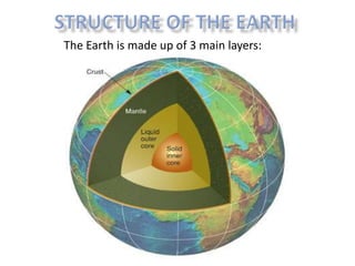
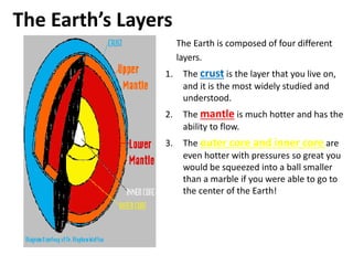
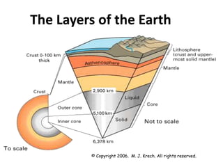
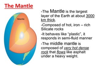
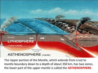
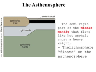
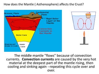
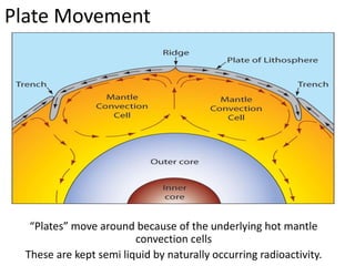
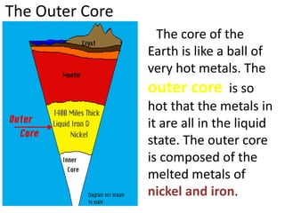
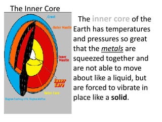
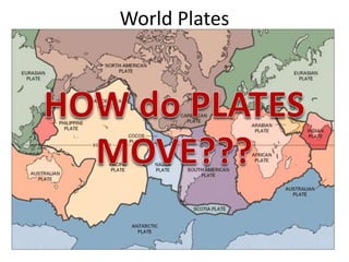
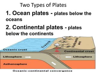
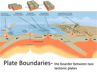
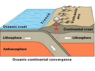
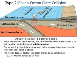
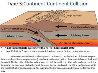
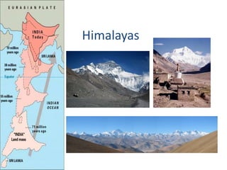
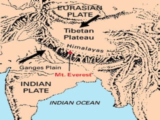
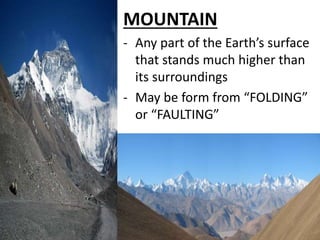
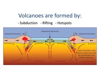
The document discusses the structure and layers of the Earth. It is composed of four main layers from outermost to innermost:
1) The crust, which is the thin solid outer layer people live on made of rocks and minerals. It is divided into thicker continental crust and thinner oceanic crust.
2) The hot, dense mantle that behaves like a solid but can flow very slowly over geologic timescales. Its convection currents influence plate tectonics at the surface.
3) The liquid outer core that is composed of melted nickel and iron due to extreme heat and pressure.
4) The inner solid core formed from compressed metals vibrating in place like a solid.
Internal Structure of The Earth
Physical Layering
Determining the Earth's Internal Structure
C. The Earth's Internal Layered Structure and Composition
D. VELOCITY AND DENSITY VARIATION WITHIN THE EARTH
The immense amount of heat energy released from gravitational energy and from the decay of radioactive elements melted the entire planet, and it is still cooling off today. Denser materials like iron (Fe) sank into the core of the Earth, while lighter silicates (Si), other oxygen (O) compounds, and water rose near the surface.
The earth is divided into four main layers: the inner core, outer core, mantle, and crust. The core is composed mostly of iron (Fe) and is so hot that the outer core is molten, with about 10% sulphur (S). The inner core is under such extreme pressure that it remains solid. Most of the Earth's mass is in the mantle, which is composed of iron (Fe), magnesium (Mg), aluminum (Al), silicon (Si), and oxygen (O) silicate compounds. At over 1000 degrees C, the mantle is solid but can deform slowly in a plastic manner. The crust is much thinner than any of the other layers, and is composed of the least dense potassium (K), calcium (Ca) and sodium (Na) aluminum-silicate minerals. Being relatively cold, the crust is rocky and brittle, so it can fracture in earthquakes.
The presentation aiding the lecture Structure of Earth and its Composition for the course CE 8392 Engineering Geology handled by Prof. Rathnavel Pon for Akshaya College of Engineering and Technology, Coimbatore
Plate tectonics is the theory that Earth's outer shell is divided into several plates that glide over the mantle, the rocky inner layer above the core. The plates act like a hard and rigid shell compared to Earth's mantle. This strong outer layer is called the lithosphere.
CSEC Geography- Internal Forces - Plate Tectonics and EarthquakesOral Johnson
This document looks at the Earth's internal forces. The main layers of the earth are described. The history surrounding plate tectonics is discussed. The different types of plate boundaries is also explained.
Oceanography is an interesting subject. Geological oceanography deals with a lot of unique aspects of the oceans including the ocean morphology and relief, continental margins, tectonic processes acting on the ocean bottoms, marine mineral resources, and the deep sea deposits. The subject also focuses on the never ending dynamic processes like ocean waters, ocean currents and their impacts with reference to space and time. Understanding the tectonic disposition and movement of crustal plates are an important part while studying the earth and atmospheric sciences, in general and oceanography, in particular. The continental margins and the deep ocean basins are the two major aspects to be understood in this subject. This lesson is on the characteristics of continental margins.
This is the entire CSEC geography syllabus (some things might be missing). The information was collected from various websites and textbooks. The topics are:
- Internal forces
-External forces
-Rivers
-Limestone
-Coasts
-Coral reefs and Mangroves
-Weather and Climate
- Ecosystems (vegetation and soils)
-Natural hazards
- Urbanization
-Economic activity
-Environmental degradation
Prepared by: Group 1
Leader:
Bau, Ella Mae G.
Members:
Adem, Angelie Lyka L.
Amper, Catherine Mae S.
Atienza, Trisha Lane M.
Babela, Ma. Ella V.
Bagang, Aleli M.
Bartolome, Kristine Joy G.
Bayani, Emanuel M.
Cabrera, Kathleen Anne A.
Students, digital devices and success - Andreas Schleicher - 27 May 2024..pptxEduSkills OECD
Andreas Schleicher presents at the OECD webinar ‘Digital devices in schools: detrimental distraction or secret to success?’ on 27 May 2024. The presentation was based on findings from PISA 2022 results and the webinar helped launch the PISA in Focus ‘Managing screen time: How to protect and equip students against distraction’ https://www.oecd-ilibrary.org/education/managing-screen-time_7c225af4-en and the OECD Education Policy Perspective ‘Students, digital devices and success’ can be found here - https://oe.cd/il/5yV
Operation “Blue Star” is the only event in the history of Independent India where the state went into war with its own people. Even after about 40 years it is not clear if it was culmination of states anger over people of the region, a political game of power or start of dictatorial chapter in the democratic setup.
The people of Punjab felt alienated from main stream due to denial of their just demands during a long democratic struggle since independence. As it happen all over the word, it led to militant struggle with great loss of lives of military, police and civilian personnel. Killing of Indira Gandhi and massacre of innocent Sikhs in Delhi and other India cities was also associated with this movement.
The French Revolution, which began in 1789, was a period of radical social and political upheaval in France. It marked the decline of absolute monarchies, the rise of secular and democratic republics, and the eventual rise of Napoleon Bonaparte. This revolutionary period is crucial in understanding the transition from feudalism to modernity in Europe.
For more information, visit-www.vavaclasses.com
Instructions for Submissions thorugh G- Classroom.pptxJheel Barad
This presentation provides a briefing on how to upload submissions and documents in Google Classroom. It was prepared as part of an orientation for new Sainik School in-service teacher trainees. As a training officer, my goal is to ensure that you are comfortable and proficient with this essential tool for managing assignments and fostering student engagement.
The Indian economy is classified into different sectors to simplify the analysis and understanding of economic activities. For Class 10, it's essential to grasp the sectors of the Indian economy, understand their characteristics, and recognize their importance. This guide will provide detailed notes on the Sectors of the Indian Economy Class 10, using specific long-tail keywords to enhance comprehension.
For more information, visit-www.vavaclasses.com
Ethnobotany and Ethnopharmacology:
Ethnobotany in herbal drug evaluation,
Impact of Ethnobotany in traditional medicine,
New development in herbals,
Bio-prospecting tools for drug discovery,
Role of Ethnopharmacology in drug evaluation,
Reverse Pharmacology.
How to Make a Field invisible in Odoo 17Celine George
It is possible to hide or invisible some fields in odoo. Commonly using “invisible” attribute in the field definition to invisible the fields. This slide will show how to make a field invisible in odoo 17.
This is a presentation by Dada Robert in a Your Skill Boost masterclass organised by the Excellence Foundation for South Sudan (EFSS) on Saturday, the 25th and Sunday, the 26th of May 2024.
He discussed the concept of quality improvement, emphasizing its applicability to various aspects of life, including personal, project, and program improvements. He defined quality as doing the right thing at the right time in the right way to achieve the best possible results and discussed the concept of the "gap" between what we know and what we do, and how this gap represents the areas we need to improve. He explained the scientific approach to quality improvement, which involves systematic performance analysis, testing and learning, and implementing change ideas. He also highlighted the importance of client focus and a team approach to quality improvement.
The Art Pastor's Guide to Sabbath | Steve ThomasonSteve Thomason
What is the purpose of the Sabbath Law in the Torah. It is interesting to compare how the context of the law shifts from Exodus to Deuteronomy. Who gets to rest, and why?
Read| The latest issue of The Challenger is here! We are thrilled to announce that our school paper has qualified for the NATIONAL SCHOOLS PRESS CONFERENCE (NSPC) 2024. Thank you for your unwavering support and trust. Dive into the stories that made us stand out!
3. How do we know so much about
what’s under Earth’s surface?
Through INDIRECT EVIDENCE, mostly from
seismic waves caused by earthquakes (more on
this later this semester...)
Sometimes indirect evidence is the only option
for scientists to develop a theory
4. How far have scientists drilled
into the earth?
-7.6 miles
- Only 0.2% of the distance to
the earth’s core
5. The Earth’s Layers
The Earth is composed of four different
layers.
1. The crust is the layer that you live on,
and it is the most widely studied and
understood.
2. The mantle is much hotter and has the
ability to flow.
3. The outer core and inner core are
even hotter with pressures so great you
would be squeezed into a ball smaller
than a marble if you were able to go to
the center of the Earth!
7. The “CRUST”
- It is where We Live!
- The uppermost portion of the Lithosphere
- Mainly composed of different Rocks and Minerals
- It is relatively Rigid and Brittle and resist deformation instead of flowing
8. 2 Types of Crust
Continental Crust
- thick, less dense than oceanic
crust and mostly old
- about 25 miles (32 kilometers)
thick under the continents
-Is mostly composed of
GRANITE
Oceanic Crust
-thin, dense - sinks under
continental crust and young
- is only about 3-5 miles (8
kilometers) thick under the oceans
- is mostly composed of BASALT
10. The Mantle
-The Mantle is the largest
layer of the Earth at about 3000
km thick.
-Composed of hot, iron – rich
Silicate rocks
-It behaves like “plastic”, it
responds in semi-fluid manner
-The middle mantle is
composed of very hot dense
rock that flows like asphalt
under a heavy weight.
Mantle
11. The Upper portion of the Mantle, which extends from crust to
mantle boundary down to a depth of about 350 km, has two zones,
the lower part of the upper mantle is called the ASTHENOSPHERE.
12. The Asthenosphere
- The semi-rigid
part of the middle
mantle that flows
like hot asphalt
under a heavy
weight.
- Thelithosphere
“floats” on the
asthenosphere
13. How does the Mantle ( Asthenosphere) affects the Crust?
The middle mantle "flows" because of convection
currents. Convection currents are caused by the very hot
material at the deepest part of the mantle rising, then
cooling and sinking again --repeating this cycle over and
over.
14. Plate Movement
“Plates” move around because of the underlying hot mantle
convection cells
These are kept semi liquid by naturally occurring radioactivity.
15. The Outer Core
The core of the
Earth is like a ball of
very hot metals. The
outer core is so
hot that the metals in
it are all in the liquid
state. The outer core
is composed of the
melted metals of
nickel and iron.
16. The Inner Core
The inner core of the
Earth has temperatures
and pressures so great
that the metals are
squeezed together and
are not able to move
about like a liquid, but
are forced to vibrate in
place like a solid.
22. Features of Divergent Boundaries
• Spreading ridges ( Seafloor Spreading )
– As plates move apart new material is erupted to fill the gap
– Can be thought as “constructive plate margins” because
this is where new oceanic crust is created
23.
24. • Iceland has a divergent plate boundary running
through its middle
Iceland: An example of continental rifting
25.
26. B. Convergent Boundaries
- Boundaries
between two
plates that are
coming together
or colliding
• There are 3 types…
– Continent-continent collision
– Continent-oceanic crust collision
– Ocean-ocean collision
27. Type 1: Continent-Oceanic Crust Collision
• Ocean plate colliding with a less dense Continental plate
• Subduction Zone: where the less dense plate slides under the more
dense plate
• VOLCANOES occur at subduction zones
28.
29. Type 2:Ocean-Ocean Plate Collision
• When two oceanic plates collide, one runs over the other which causes it to
sink into the mantle forming a subduction zone.
• The subducting plate is bent downward to form a very deep depression in
the ocean floor called a trench.
• The worlds deepest parts of the ocean are found along trenches.
– E.g. The Mariana Trench is 11 km deep!
30. Manned or unmanned submersible vehicles (top right photo) have explored small
parts of trenches discovering new species (like the fish photographed here) and
amazing ecosystems.
32. Type 3:Continent-Continent Collision
• A Continental plate colliding with another Continental plate
• Have Collision Zones: a place where folded and thrust faulted mountains form.
When continental crust pushes against continental crust both sides of the convergent
boundary have the same properties (think back to the description of continental crust: thick and
buoyant). Neither side of the boundary wants to sink beneath the other side, and as a result the
two plates push against each other and the crust buckles and cracks, pushing up (and down into
the mantle) high mountain ranges. For example, the European Alps and Himalayas formed this
way.
39. 2. CONVECTION CURRENT - Hot magma in
the Earth moves toward the surface,
cools, then sinks again.Creates
convection currents beneath the
plates that cause the plates to move.
1. DIASTROPHISM- early term for all
movement of the Earth’s crust.
Thought to result in the formation
of mountains, ocean basins, etc.
40. 3. CONTRACTING EARTH THEORY - Theory that
the Earth contracted or shrank over geologic
time
Shrinking resulted
in a reduction in the
Earth’s diameter
while the
circumference
remained unchanged
due to folding and
buckling of the crust
(diastrophism).
41. First evidence: The jigsaw fit of the outline of the continental margins.
Frances Bacon (1620): while reviewing the first maps of the coastlines
of Africa and South America noted that the outlines of the continents
appear as if they could fit together.
4. CONTINENTAL DRIFT THEORY
42. In 1858 Antonio Snider-Pellegrini made the following
“before and after” maps of South America and Africa.
43. Frances Placet (1668) was the first to suggest that the continents were
actually fixed together as suggested by their outlines.
Suggested that the continents had been torn apart by the biblical flood.
Born: Germany, 1880
PhD: Astronomy
Profession: Meteorologist and Greenland Explorer.
Died: 1930
Alfred Wegener became the “father of continental drift” by
amassing considerable supporting evidence that the
continents moved over time.
In 1915 Wegener published his work in The Origin of the Continents and Oceans.
- 250 million years ago, all of the continents were
combined into one super-continent called “Pangaea”
- The continents gradually drifted apart to where they are
today
44. PANGAEA
Laurasia Gondwanaland
Antarctica,Africa,
Australia, South America
and India
Eurasia & North America
The theory suggest that seismic activity, such as earthquakes, volcanic eruptions, and tsunamis
eventually created fissures or cracks in the Erath. As these fissures became larger, longer and
deeper, the Pangaea broke off .
45.
46. Wegener’s Evidence:
The presence of fossils only over small areas of now
separate continents (how did they get from
continent to continent?).
48. MOUNTAIN
- Any part of the Earth’s surface
that stands much higher than
its surroundings
- May be form from “FOLDING”
or “FAULTING”
49. FOLDING
• When rock is subjected to compressive stress, it
begins to buckle and fold.
50. Two Kinds of FOLDS
A. ANTICLINE – forms when layers of rocks are
bend upward into an arch
B. SYNCLINE – occurs when the layers of rocks are
bent downward to form trough
Syncline
Anticline
51. FAULTING
• a FAULT is a plane along which the rocks break and slip.
It can be recognized because rock layers don’t match in
place.
52. Three Types of Fault
A. Strike Slip Fault or Horizontal Fault
B. Normal Fault
C. Reverse Fault
54. - The openings in the earth’s crust that allows magma, gases and ash to escape.
There is a great deal of heat and pressure along plate boundaries. At
the subduction zones, the heat and pressure force magma upward through
cracks in the earth’s crust.
What are Volcanoes?
Photo: Tom Pfeiffer / www.volcanodiscovery.com
The Hawaiian island chain are examples
of hotspot volcanoes.
56. - Subduction - Rifting - Hotspots
Volcanoes are formed by:
57. Types of Volcanoes: As to Activity
A. ACTIVE VOLCANO – a volcano that has erupted in the
last 100 years
B. DORMANT VOLCANO – a volcano which have not
erupted in the last 100-1000 years
C. EXTINCT VOLCANO – a volcano that has not been active
for over 1000 years.
58. The tectonic plate moves over a fixed hotspot forming a chain
of volcanoes.
The volcanoes get younger from one end to the other.
60. • As with volcanoes, earthquakes are not
randomly distributed over the globe
• At the boundaries between plates, friction
causes them to stick together. When built up
energy causes them to break, earthquakes occur.
Figure showing the
distribution of
earthquakes
around the globe
61. EARTHQUAKES
- are the shaking, rolling or sudden shock of the earth’s
surface.
- happen along "fault lines" in the earth’s crust.
-can be felt over large areas although they usually last
less than one minute.
-cannot be predicted -- although scientists are working
on it!
63. We know there are three types of plate boundaries: Divergent, Convergent and
Transform. Movement and slipping along each of these types of boundaries can
form an earthquake.
•Depending on the type of movement, the earthquakes occur in
either a shallow or deep level in the crust.
•The majority of tectonic earthquakes originate at depths not
exceeding tens of kilometers.
•In subduction zones, where old and cold oceanic crust descends
beneath another tectonic plate, “Deep Focus Earthquakes” may
occur at much greater depths (up to seven hundred kilometers!).
•These earthquakes occur at a depth at which the subducted crust
should no longer be brittle, due to the high temperature and
pressure. A possible mechanism for the generation of deep focus
earthquakes is faulting.
• Earthquakes may also occur in volcanic regions and are caused
there both by tectonic faults and by the movement of magma (hot
molten rock) within the volcano. Such earthquakes can be an
early warning of volcanic eruptions.
64.
65. FOCUS – the place along a
fault where an earthquake
begins
SEISMIC WAVES )))))) – the
energy that moves outward
from the focus causing the
earths surface to vibrate.
EPICENTER– the place on the
surface directly above the
focus
66. Earthquake waves are known as seismic
waves. There are two main types of seismic
waves. Each type of wave has a characteristic
speed and manner of travel.
67. A. BODY WAVES – travel through the
earth’ interior
A.1. Primary Waves - Seismic waves that
travel the fastest. P waves arrive at a given
point before any other type of seismic wave.
P waves travel through solids, liquids and
gases.
68. A.2. Secondary Waves - Seismic waves that do
not travel through the Earth as fast as P waves
do are secondary waves, or S waves. S waves
arrive at a given point after P waves do. S waves
travel through solids but not through liquids and
gases.
69. B. Surface Waves – travel through the Earth’s
surface.
- The slowest-moving seismic waves are called surface waves, or L waves. L
waves arrive at a given point after primary and secondary waves do. L waves
originate at the epicenter. Surface waves travel along the surface of the earth,
rather than down into the earth. Although they are the slowest of all the
earthquake waves, L waves usually cause more damage than P or S waves.
2 Types:
B.1. Love Waves –
move in a side-to-
side, whip like motion
B.2. Rayleigh Waves –
moves in an up and
down motion
70. MEASURING EARTHQUAKES
MAGNITUDE – measures the energy released
at the source (Epicenter) of the earthquake and
determined by the Richter Scale
RICHTER SCALE EFFECTS of TREMOR
2
Only detected by
seismographs
4
Felt by walkers, windows and
doors rattle.
6
Severe structural damage to
houses
8
Total destruction, ground
actually rises and falls.
71. This is an image of a seismograph, an instrument
used to record the energy released by an
earthquake. When the needle is moved by the
motion of the earth, it leaves a wavy line.
72. INTENSITY – measures the strength of shaking
produced by the earthquake at a certain location.
-It is determine from the effects on people,
human structures, and the natural environment.
-Is measured by MODIFIED MERCALLI SCALE
(MMS) which ranges from scale I-XII (see Fig.4.32 on
page 143 f your Phy.Sci book.)
73. Earthquakes: Facts and Fiction
Fiction: Earthquakes usually happen in the morning.
Fact: Earthquakes happen in both the day and the night.
There is no pattern.
Fiction: There is such a thing as "earthquake weather."
Fact: There is no connection between earthquakes and
weather. Remember, earthquakes happen deep in the
earth, far away from the weather!
Fiction: Earthquakes are on the increase.
Fact: It may seem like we’re having more earthquakes
because there are more reporting stations, but the
truth is we’re not.
Fiction: We can prevent earthquakes from happening.
Fact: No. You can protect yourself by doing things to secure
buildings, like your home, but earthquakes can’t be
prevented -- or predicted.