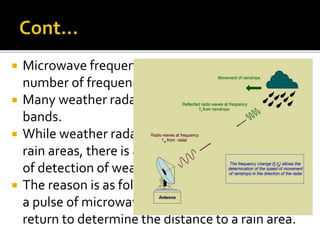
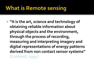
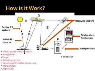
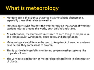
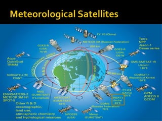
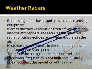
DEPARTMENT OF GEOGRAPHY 
SOUTH EASTERN UNIVERSITY OF SRILANKA.
 What is Remote sensing 
 Field of Application 
 What is meteorology 
 Why Meteorological Satellites? 
 Types of Weather Satellite Images 
 Meteorological Satellites 
 Weather Radars 
 Advantages of Satellite weather forecasting 
 Disadvantages of Satellite weather forecasting
 “It is the art, science and technology of 
obtaining reliable information about 
physical objects and the environment, 
through the process of recording, 
measuring and interpreting imagery and 
digital representations of energy patterns 
derived from non contact sensor systems” 
(Coldwell, 1997)
Passive RS 
systems 
Active RS 
systems 
• Energy source: Passive/Active 
• Atmosphere 
• Target 
• Recording devices 
• Transmission/reception/processing 
• Interpretation 
• Application 
Receiving stations 
Final product 
Application 
Interpretation
 Meteorology is the science that studies atmospheric phenomena, 
especially those that relate to weather. 
 Meteorologists who forecast the weather rely on thousands of weather 
stations located around the world, both on land and at sea. 
 At each station, measurements are taken of such things as air pressure 
and temperature, wind speed, cloud cover, and precipitation. 
 Meteorological satellites can be used to keep track of weather systems 
days before they come close to an area. 
 This is particularly useful in monitoring severe weather systems like 
tropical cyclones. 
 The very basic application of meteorological satellite is in identification 
of clouds.
 Clouds can be broadly classified into three categories according to the 
cloud base height, namely, low, medium and high clouds. Some clouds, 
such as cumulonimbus (a type of thundery clouds), span the three layers. 
 Sensors onboard meteorological satellites are pointing towards the 
ground, enabling them to have bird eye view of the globe from the space. 
 There are two types of meteorological satellites characterized by their 
orbits. 
 They are geostationary satellites and polar-orbiting satellites. As the 
name suggests, a geostationary satellite is stationary relative to the 
earth. 
 That is, it moves above the equator at the same rate as the earth's 
rotation so that all the time it is above the same geographical area on the 
earth.
 In this manner, it is capable of taking cloud images of the same 
area continuously, 24 hours a day. 
 As it is some 35,800 kilometers from the earth, it is capable of 
taking cloud pictures covering part of the whole globe. 
 These satellites together provide full coverage of the earth. 
 Polar-orbiting satellites are low-flying satellites circling the 
earth in a nearly north-south orbit, at several hundred 
kilometers above the earth. 
 Most of them pass over the same place a couple of times a day.
 Satellite data have considerably improved 
weather prediction, in part because of the 
information they provide over data-sparse 
areas. 
 This includes the oceans, which cover almost 
three-quarters of the earth's surface and 
most of the Southern Hemisphere.
 Environmental satellites provide data in several different formats. 
 The most commonly used channels on weather satellites used are 
the visible, infrared, and water vapor satellites. 
 Visible (~0.6 μm) ,Infrared or IR (10 to 12 μm), Water vapor (6.5 to 
6.7 μm) 
 Each of these channels on the satellite sensors is sensitive to 
energy (electromagnetic energy) at a particular range of 
frequencies, therefore each type provides a different view of the 
Earth, its atmosphere, and its oceans. 
 Researchers rely on all three types of data, and often use them 
together to better understand the interactions between the 
atmosphere, oceans, and the Earth's surface.
 Radar is a ground-based and active remote sensing 
equipment. 
 It emits microwave radiation from a fixed location 
into the atmosphere and receives the reflected 
radiation called echoes from water droplets in the 
air. 
 Microwave is not intense in the solar radiation and 
the earth's emission spectrum. 
 Therefore the background radiation level in the 
microwave frequencies is not high and it usually 
does not affect the operation of the radar.
 Microwave frequencies can be divided into a 
number of frequency bands. 
 Many weather radars operate in the S and C 
bands. 
 While weather radar can measure the distance of 
rain areas, there is a limit to the effective range 
of detection of weather radar. 
 The reason is as follows: weather radar transmits 
a pulse of microwave and waits for the pulse to 
return to determine the distance to a rain area.
We can get the weather information accurately 
for using weather satellite. 
 we can observation the atmosphere conditions 
in every second.. 
 When we get bad weather .. That time also we 
can get the weather information in reliability 
and accurately. 
 Uneducated People also know about the 
weather information through the 
communication..(Television and Radio)
 It is high Expensive. 
 It is depend in trained People.
Remote sensing for

Remote sensing for

  • 1.
    DEPARTMENT OF GEOGRAPHY SOUTH EASTERN UNIVERSITY OF SRILANKA.
  • 2.
     What isRemote sensing  Field of Application  What is meteorology  Why Meteorological Satellites?  Types of Weather Satellite Images  Meteorological Satellites  Weather Radars  Advantages of Satellite weather forecasting  Disadvantages of Satellite weather forecasting
  • 3.
     “It isthe art, science and technology of obtaining reliable information about physical objects and the environment, through the process of recording, measuring and interpreting imagery and digital representations of energy patterns derived from non contact sensor systems” (Coldwell, 1997)
  • 4.
    Passive RS systems Active RS systems • Energy source: Passive/Active • Atmosphere • Target • Recording devices • Transmission/reception/processing • Interpretation • Application Receiving stations Final product Application Interpretation
  • 6.
     Meteorology isthe science that studies atmospheric phenomena, especially those that relate to weather.  Meteorologists who forecast the weather rely on thousands of weather stations located around the world, both on land and at sea.  At each station, measurements are taken of such things as air pressure and temperature, wind speed, cloud cover, and precipitation.  Meteorological satellites can be used to keep track of weather systems days before they come close to an area.  This is particularly useful in monitoring severe weather systems like tropical cyclones.  The very basic application of meteorological satellite is in identification of clouds.
  • 7.
     Clouds canbe broadly classified into three categories according to the cloud base height, namely, low, medium and high clouds. Some clouds, such as cumulonimbus (a type of thundery clouds), span the three layers.  Sensors onboard meteorological satellites are pointing towards the ground, enabling them to have bird eye view of the globe from the space.  There are two types of meteorological satellites characterized by their orbits.  They are geostationary satellites and polar-orbiting satellites. As the name suggests, a geostationary satellite is stationary relative to the earth.  That is, it moves above the equator at the same rate as the earth's rotation so that all the time it is above the same geographical area on the earth.
  • 8.
     In thismanner, it is capable of taking cloud images of the same area continuously, 24 hours a day.  As it is some 35,800 kilometers from the earth, it is capable of taking cloud pictures covering part of the whole globe.  These satellites together provide full coverage of the earth.  Polar-orbiting satellites are low-flying satellites circling the earth in a nearly north-south orbit, at several hundred kilometers above the earth.  Most of them pass over the same place a couple of times a day.
  • 9.
     Satellite datahave considerably improved weather prediction, in part because of the information they provide over data-sparse areas.  This includes the oceans, which cover almost three-quarters of the earth's surface and most of the Southern Hemisphere.
  • 10.
     Environmental satellitesprovide data in several different formats.  The most commonly used channels on weather satellites used are the visible, infrared, and water vapor satellites.  Visible (~0.6 μm) ,Infrared or IR (10 to 12 μm), Water vapor (6.5 to 6.7 μm)  Each of these channels on the satellite sensors is sensitive to energy (electromagnetic energy) at a particular range of frequencies, therefore each type provides a different view of the Earth, its atmosphere, and its oceans.  Researchers rely on all three types of data, and often use them together to better understand the interactions between the atmosphere, oceans, and the Earth's surface.
  • 12.
     Radar isa ground-based and active remote sensing equipment.  It emits microwave radiation from a fixed location into the atmosphere and receives the reflected radiation called echoes from water droplets in the air.  Microwave is not intense in the solar radiation and the earth's emission spectrum.  Therefore the background radiation level in the microwave frequencies is not high and it usually does not affect the operation of the radar.
  • 13.
     Microwave frequenciescan be divided into a number of frequency bands.  Many weather radars operate in the S and C bands.  While weather radar can measure the distance of rain areas, there is a limit to the effective range of detection of weather radar.  The reason is as follows: weather radar transmits a pulse of microwave and waits for the pulse to return to determine the distance to a rain area.
  • 14.
    We can getthe weather information accurately for using weather satellite.  we can observation the atmosphere conditions in every second..  When we get bad weather .. That time also we can get the weather information in reliability and accurately.  Uneducated People also know about the weather information through the communication..(Television and Radio)
  • 15.
     It ishigh Expensive.  It is depend in trained People.

Editor's Notes

  • #2 COMS · COMS Communication, Ocean and Meteorological Satellite - KOMPSAT (Korea)
  • #5 Energy Source or Illumination (A) - the first requirement for remote sensing is to have an energy source which illuminates or provides electromagnetic energy to the target of interest. Radiation and the Atmosphere (B) - as the energy travels from its source to the target, it will come in contact with and interact with the atmosphere it passes through. This interaction may take place a second time as the energy travels from the target to the sensor. Interaction with the Target (C) - once the energy makes its way to the target through the atmosphere, it interacts with the target depending on the properties of both the target and the radiation. Recording of Energy by the Sensor (D) - after the energy has been scattered by, or emitted from the target, we require a sensor (remote - not in contact with the target) to collect and record the electromagnetic radiation. Transmission, Reception, and Processing (E) - the energy recorded by the sensor has to be transmitted, often in electronic form, to a receiving and processing station where the data are processed into an image (hardcopy and/or digital). Interpretation and Analysis (F) - the processed image is interpreted, visually and/or digitally or electronically, to extract information about the target which was illuminated. Application (G) - the final element of the remote sensing process is achieved when we apply the information that we have been able to extract from the imagery about the target, in order to better understand it, reveal some new information, or assist in solving a particular problem.
  • #10 Hemisphere-உலகின் அரை உருண்டை
  • #11 Types of Satellite Images Both of these types of satellites take measurements of different wavelengths of radiation. There are three widely used atmospheric windows (channels) That allow radiation from the lower atmosphere to space: Visible (~0.6 μm) Visible images record visible light from the sun reflected back to the satellite by cloud tops, land, and sea surfaces. Equivalently a black and white photograph from space. Visible images can only be made during daylight.Dark areas: Regions where small amounts of visible light are reflected back to space. i.e. forests, oceans Bright areas: Regions where large amounts of visible light are reflected back to space. i.e. snow, thick clouds Current Visible Image Infrared or IR (10 to 12 μm) Infrared images record infrared radiation emitted directly by cloud tops, land, or ocean surfaces. Cooler temperatures shown as light gray tones. Warmer temperatures shown as dark gray tones. Current IR Image Water vapor (6.5 to 6.7 μm) Water vapor images record infrared radiation emitted by water vapor in the atmosphere. Bright, white shades represent radiation from a moist layer or cloud in the upper troposphere (cold brightness temperature). Dark, gray/black shades represent radiation from the Earth or a dry layer in the middle troposphere (warm brightness temperature). Current WV Image