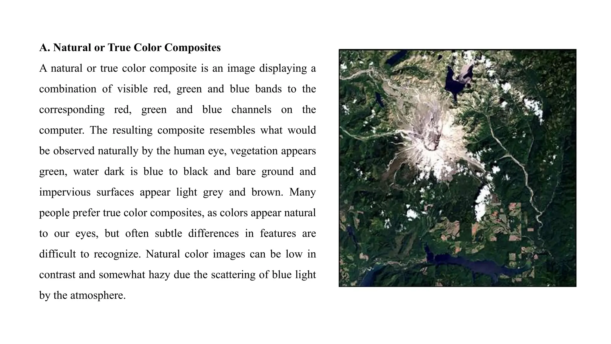
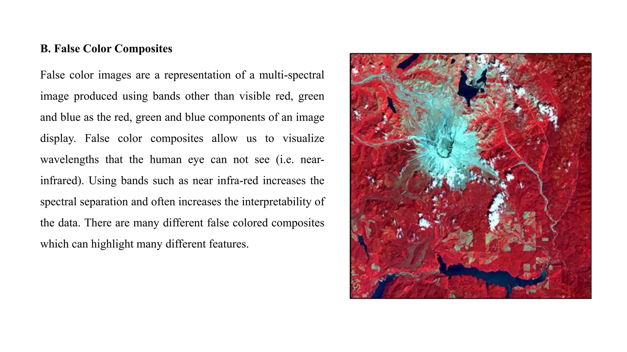
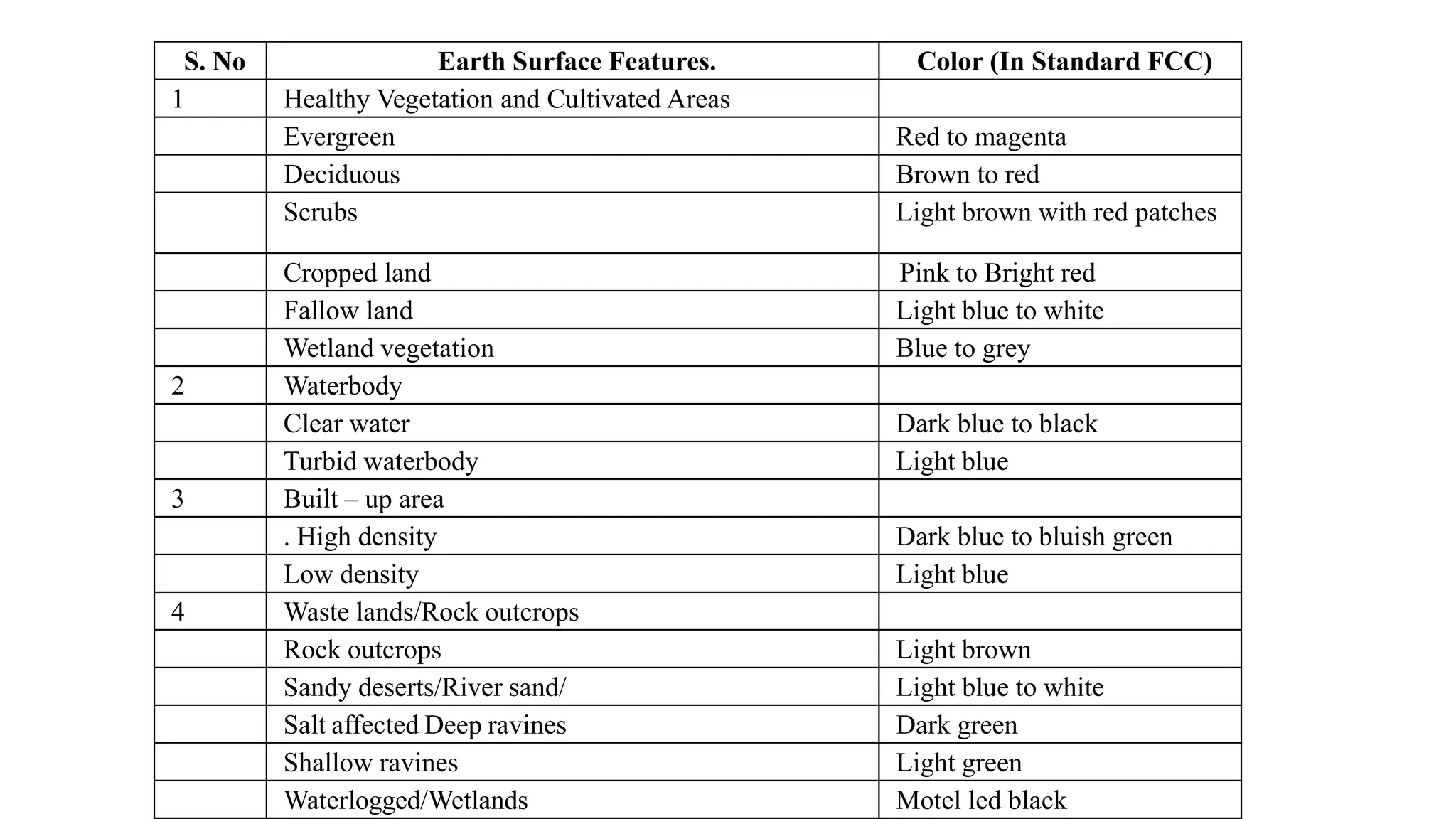
2. A. Natural or True Color Composites
A natural or true color composite is an image displaying a
combination of visible red, green and blue bands to the
corresponding red, green and blue channels on the
computer. The resulting composite resembles what would
be observed naturally by the human eye, vegetation appears
green, water dark is blue to black and bare ground and
impervious surfaces appear light grey and brown. Many
people prefer true color composites, as colors appear natural
to our eyes, but often subtle differences in features are
difficult to recognize. Natural color images can be low in
contrast and somewhat hazy due the scattering of blue light
by the atmosphere.
3. B. False Color Composites
False color images are a representation of a multi-spectral
image produced using bands other than visible red, green
and blue as the red, green and blue components of an image
display. False color composites allow us to visualize
wavelengths that the human eye can not see (i.e. near-
infrared). Using bands such as near infra-red increases the
spectral separation and often increases the interpretability of
the data. There are many different false colored composites
which can highlight many different features.
4. C. Standard False Colour Composite
A standard False Colour Composite (FCC) is an image created by combining data from multiple spectral bands of a
satellite or other image sensor. Unlike natural color composites, which use the red, green and blue (RGB) bands, FCCs use
different combinations of bands to create a composite image that emphasizes features of interest. By assigning different
colors to different wavelengths of light, FCCs can reveal features that may be invisible or difficult to see in a natural color
image.
Here's a breakdown of a standard FCC:
Near Infrared (NIR) assigned as Red: Healthy vegetation reflects strongly in the NIR band, so it appears bright red
in an FCC. This makes it easy to distinguish healthy vegetation from other features in the image.
Red assigned as Green: In a standard FCC, the red band is often assigned to the green channel. This can help to
highlight features that are red in color, such as iron oxides or blood.
Green assigned as Blue: The green band is frequently assigned to the blue channel in a standard FCC. This can help
to distinguish between different types of vegetation, as some plants reflect more green light than others.
5. S. No Earth Surface Features. Color (In Standard FCC)
1 Healthy Vegetation and Cultivated Areas
Evergreen Red to magenta
Deciduous Brown to red
Scrubs Light brown with red patches
Cropped land Pink to Bright red
Fallow land Light blue to white
Wetland vegetation Blue to grey
2 Waterbody
Clear water Dark blue to black
Turbid waterbody Light blue
3 Built – up area
. High density Dark blue to bluish green
Low density Light blue
4 Waste lands/Rock outcrops
Rock outcrops Light brown
Sandy deserts/River sand/ Light blue to white
Salt affected Deep ravines Dark green
Shallow ravines Light green
Waterlogged/Wetlands Motel led black
6. Image Classification Techniques in Remote Sensing
A. Supervised Classification:
It is the process of identification of classes within a remote sensing data with inputs from and as directed by the user
in the form of training data.
Supervised image classification is a powerful technique used to categorize pixels in a satellite image into specific
classes, such as water, forest, urban areas, or different crop types. It works by leveraging human knowledge to
"train" the computer to recognize these classes.
B. Unsupervised Classification:
It is the process of automatic identification of natural groups or structures within a remote sensing data.
Unsupervised image classification takes a different approach to categorizing pixels in satellite images. Instead of
relying on pre-defined classes and labelled training data, it allows the computer to discover inherent groupings
(clusters) within the data itself.
7. Image Classification Techniques in Remote
A. Supervised Classification:
It is the process of identification of classes within a remote sensing data with inputs from and as directed by the user
in the form of training data.
Supervised image classification is a powerful technique used to categorize pixels in a satellite image into specific
classes, such as water, forest, urban areas, or different crop types. It works by leveraging human knowledge to
"train" the computer to recognize these classes.
B. Unsupervised Classification:
It is the process of automatic identification of natural groups or structures within a remote sensing data.
Unsupervised image classification takes a different approach to categorizing pixels in satellite images. Instead of
relying on pre-defined classes and labelled training data, it allows the computer to discover inherent groupings
(clusters) within the data itself.