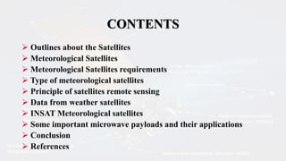
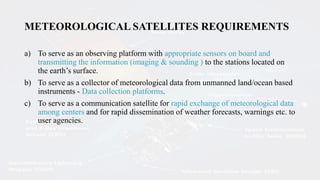
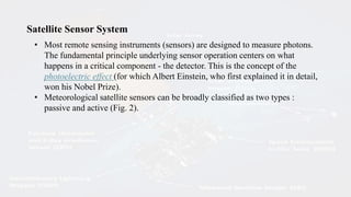
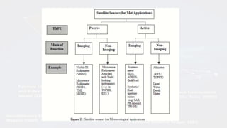
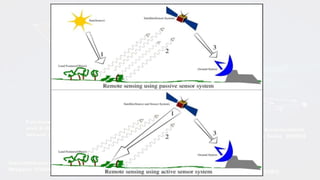
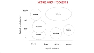
SlideShare a Scribd company logo
1 of 43
WELCOME
METEOROLOGICAL
SATELLITES
Presented by: Vasudevan M
MSc Geology 5th year (Integrated)
Department of Earth sciences
Annamalai University
(2022-2023)
CONTENTS
 Outlines about the Satellites
 Meteorological Satellites
 Meteorological Satellites requirements
 Type of meteorological satellites
 Principle of satellites remote sensing
 Data from weather satellites
 INSAT Meteorological satellites
 Some important microwave payloads and their applications
 Conclusion
 References
What Is a Satellite?
A satellite is a moon, planet or machine that orbits a planet or star. For
example, Earth is a satellite because it orbits the sun. Likewise, the moon is a
satellite because it orbits Earth. Usually, the word "satellite" refers to a machine
that is launched into space and moves around Earth or another body in space.
Why Are Satellites Important?
The bird's-eye view that satellites have allows them to see large areas of
Earth at one time. This ability means satellites can collect more data, more
quickly, than instruments on the ground.
Outlines about The satellites
What Are the Parts of a Satellite?
Satellites come in many shapes and sizes. But most have at least two parts in
common - an antenna and a power source. The antenna sends and receives
information, often to and from Earth. The power source can be a solar panel or
battery.
Solar panels make power by turning sunlight into electricity.
Many NASA satellites carry cameras and scientific sensors. Sometimes these
instruments point toward Earth to gather information about its land, air and
water. Other times they face toward space to collect data from the solar system
and universe.
How Do Satellites Orbit Earth?
Most satellites are launched into space on rockets. A satellite orbits Earth
when its speed is balanced by the pull of Earth's gravity. Without this balance,
the satellite would fly in a straight line off into space or fall back to Earth.
Satellites orbit Earth at different heights, different speeds and along different
paths. The two most common types of orbit are "geostationary" and "polar.“
A geostationary satellite travels from west to east over the equator. It moves
in the same direction and at the same rate Earth is spinning. From Earth, a
geostationary satellite looks like it is standing still since it is always above the
same location.
Polar-orbiting satellites travel in a north-south direction from pole to pole.
As Earth spins underneath, these satellites can scan the entire globe, one strip at
a time.
Why Don't Satellites Crash Into Each Other?
Actually, they can. NASA and other U.S. and international organizations keep
track of satellites in space. Collisions are rare because when a satellite is
launched, it is placed into an orbit designed to avoid other satellites. But orbits
can change over time. And the chances of a crash increase as more and more
satellites are launched into space.
In February 2009, two communications satellites - one American and one
Russian - collided in space. This, however, is believed to be the first time two
man-made satellites have collided accidentally.
What Was the First Satellite in Space?
Sputnik 1 was the first satellite in space. The Soviet Union launched it in 1957.
How satellites used today?
satellites help scientists study Earth and space.
Satellites looking toward Earth provide information about clouds, oceans,
land and ice. They also measure gases in the atmosphere, such as ozone and
carbon dioxide, and the amount of energy that Earth absorbs and emits. And
satellites monitor wildfires, volcanoes and their smoke.
All this information helps scientists predict weather and climate. The
information also helps public health officials track disease and famine; it helps
farmers know what crops to plant; and it helps emergency workers respond to
natural disasters.
Meteorological Satellites
• Meteorology is a discipline concerned with observational earth sciences and
theoretical physics.
• As a branch of observational earth sciences, it has the task of providing an
accurate knowledge of the state of the atmosphere, which can only be obtained
through regular, simultaneous observation covering the whole globe from the earth
surface to the upper atmosphere.
• Before the advent of weather satellites the weathermen had been severely
handicapped by having only a very limited knowledge of the state of the
atmosphere at any given time.
• Satellite imagery is an invaluable source of information for operational
forecasters.
It is being used as
(a) an analysis tool, especially to data sparse regions like the tropics;
(b) direct aid to short period forecasts (6-12 hours ahead of cloud, rainfall,
floods etc.;
(c) input to numerical weather prediction models (NWP) for defining initial
condition;
(d) monitoring the model forecast.
• It also serves as a valuable indicator of dynamical and physical process at
work providing the trained eye, some useful clues on atmosphere structure and
its evolution
• The sea-surface temperature, the sea surface/upper air winds from
scatterometer/cloud motion vectors provide valuable input to numerical
models.
• The rainfall from geostationary satellites, rain rate from microwave sensors,
the OLR (Outgoing Longwave Radiation) from polar orbiting satellites are a
few parameters which are frequently utilized in the initialization of the
data for numerical weather prediction of monsoon.
METEOROLOGICAL SATELLITES REQUIREMENTS
a) To serve as an observing platform with appropriate sensors on board and
transmitting the information (imaging & sounding ) to the stations located on
the earth’s surface.
b) To serve as a collector of meteorological data from unmanned land/ocean based
instruments - Data collection platforms.
c) To serve as a communication satellite for rapid exchange of meteorological data
among centers and for rapid dissemination of weather forecasts, warnings etc. to
user agencies.
TYPES OF METEOROLOGICAL SATELLITES
• Meteorological satellites are of two types viz. Polar orbiting and Geostationary
(Fig. 1 & 2).
Fig 1. Polar orbiting
satellites
Fig 2. Geostationary orbiting
satellites
1. Polar orbiting satellites
• Polar orbiting satellites pass approximately over the poles at a height of about 850
kms.
• The whole surface of the earth is observable by these satellites which follow orbits
nearly fixed in space while the earth is rotating beneath them.
• The areas scanned on each pass (swath) are nearly adjacent at the equator with
overlapping areas further poleward. The swaths are usually about 2600 km wide.
• These satellites complete 14 orbits per day and thus can provide global coverage
twice in 24 hours.
Some of the polar orbiting satellites are NOAA, IRS, ERS-1 &ERS-2, TRMM(low
inclination), DMSP, Oceansat-1 etc.
2. Geostationary satellites
• Geostationary satellites orbit around the earth over the equator at a height of about
36000 kms.
• They complete one orbit in 24 hours synchronised with earth’s rotation about its
own axis. Thus they remain over the same location on the equator.
• The main advantage of geostationary satellites lies in the high time-scale
resolution of their data. A fresh image of the full earth’s disc is available every 30
minutes.
• However they have limited spatial resolution as compared to the polar orbiting
satellites in view of their distance from the earth.
• Useful information is restricted to the belt between 70 deg. N and south latitudes.
• Some of the examples of geostationary satellites are GMS( 1400 E ), GOES-W,
GOES-E, INSAT-1 and INSAT-2 Series., GEOS, METEOSAT -5 (Positioned at 64
0 E ), METEOSAT-6 etc.
Satellite Sensor System
• Most remote sensing instruments (sensors) are designed to measure photons.
The fundamental principle underlying sensor operation centers on what
happens in a critical component - the detector. This is the concept of the
photoelectric effect (for which Albert Einstein, who first explained it in detail,
won his Nobel Prize).
• Meteorological satellite sensors can be broadly classified as two types :
passive and active (Fig. 2).
(a) Spatial Information :
The examples are the extent and temperature of sea surface, clouds,
vegetation, soil moisture, etc.
The main objective here is to obtain the required information over a 2-
dimensional plane. The best suited sensors for this class are imaging
radiometers operating in visible, infrared or microwave frequencies. Active
sensors like Synthetic Aperture Radar (SAR) are also put to effective use for the
imaging applications.
(b) Spectral Information : For certain applications, the spectral details of an
electromagnetic signal are of crucial importance. A particular object of
interest, for example an atmospheric layer, or, the ocean surface, interacts
differently with different wavelengths of electromagnetic(EM) spectra. In
most cases, this may be due to the chemical composition of the object.
• Absorption, emission, or reflection of an EM radiation from an object is a
function of the wavelength of EM radiation, and the temperature of the object.
Thus, the spectral information can provide details of chemical composition,
and/or the temperature of the object.
• Meteorological satellite sensors use this information for sounding
applications, where the vertical structure of temperature, humidity, and in
some cases, the atmospheric gases is retrieved. An example of this sensor is
High Resolution IR Sounder (HIRS), and Advance Microwave Sounding Unit
(AMSU) onboard NOAA series of satellites.
• Future satellites will carry more advanced sensors like imaging spectrometers.
Geostationary Imaging Fourier Transform Spectrometer (GIFTS) is a fine
example of this new-generation sensor. GIFTS, when operational, is expected
to provide the vertical profiles of temperature, humidity, and winds at several
atmospheric layers in vertical.
• (c) Intensity Information : The intensity of EM radiation can provide
several clues about the object of interest. In most cases, the satellite sensors
measure the intensity of the radiation reflected from the object to know the
dielectric properties and the roughness of the object. By the use of suitable
algorithms these parameters can be translated to the properties of geophysical
parameters like soil moisture, ocean surface roughness, ocean surface wind
speed, and wind direction, etc. The sensors that use this information are radar,
scatterometer, and polarimeters.
PRINCIPLES OF SATELLITE REMOTE SENSING
All objects emit electromagnetic radiation. The hotter the source, the
greater is the intensity of emission. Substances which absorb all the radiation
falling on them at every wavelength are called “black bodies”. The coefficient
of absorption is then unity. As per Kirchhoff ’s law, good absorbers are good
emitters as well. Hence a black body also has an emissivity unity. At any
wavelength it emits the maximum amount of radiation that is appropriate to
its temperature.
Solar radiation is in shorter wavelengths and the terrestrial radiation is in longer
wavelengths. Solar radiation of significant intensity occurs at wavelengths
between 0.2 and 4.0 μm, the peak intensity at about 0.5 μm in the visible
part of the spectrum. Terrestrial radiation is emitted at wavelengths between
3 and 100 μm which falls entirely within the infrared region. The maximum
intensity is around 11 μm.
• Unlike solids and liquids, gases are not black bodies. They only absorb or
emit strongly at certain wavelengths. Water vapour (H2O), carbon dioxide
(CO2) and ozone (O3) are such gases within the visible and infrared wave
bands that are important in meteorology.
• Each of these gases is active in certain narrow absorption bands. There are
other regions where the absorption by all the gases is so weak that the
atmosphere is almost transparent.
• These regions are known as “windows” and are used for production of cloud
imagery.
• Satellite imagery is obtained from radiometers that measure scattered
electromagnetic radiation emitted from the sun, earth and the atmosphere.
The satellite imageries in common operational use are :
• a) Visible (VIS) - imagery derived from reflected sunlight at visible and near
infrared wavelength (0.4 - 1.1 μm).
• b) Infrared (IR) imagery (Fig. 3) derived from emissions by the earth and its
atmosphere at thermal infrared wavelengths (10-12 μm)
• c) Water Vapour (WV) imagery derived from water vapour emissions (6-7μm)
• d) 3.7μm (often referred to as channel 3) imagery in the overlap region of solar
and terrestrial radiation and hence sometimes called near IR.
• e) Images from microwave radiometer such as Special Sensor Microwave/
• Imager (SSM/I), and TRMM Microwave Imagers (TMI) can provide a lot of
useful information. Microwave radiation is not affected by the presence of clouds
and that is an important factor in the science of weather. Microwave observations
are widely used for inferring sea surface temperature, sea surface wind speed and
atmospheric water vapor content (over ocean surfaces), cloud liquid water content,
rainfall, and the fraction of ice/snow particles within the raining systems.
DATA FROM WEATHER SATELLITES
• The initial phases of the satellite era (almost for two decades) saw the use of visual
imageries provided by the polar orbiting satellites. Towards the end of the
seventies the sounders in polar orbiting satellites, the shifting of the US GOES
satellite to the Indian latitudes during MONEX experiment and the launch of
Japanese GMS satellites provided new avenues.
• The beginning of eighties saw the INSAT series of the meteorological satellites.
The new generation of INSAT satellites to be launched in couple of years from
now would have much more atmospheric information over this part of the Asian
continent. Besides some experimental satellites such as the Defense
meteorological satellite, ERS-1 and satellite like TRMM, are providing valuable
information in describing the monsoon features, water vapour , SST, wind and
rainfall (Kidder and Vonder Haar, 1995).
• Tropical rainfall affects the lives and economies of a majority of the earth’s
population. Tropical rain systems like hurricane, typhoons and monsoons are
crucial to sustaining the live hoods of those living in the tropics. Exces floods can
cause drought and crop failure.
• The TRMM ( Tropical Rainfall Measuring Mission) satellite’s low inclination
(35degrees), non-sun synchronous, and highly processing orbits allow it to fly
over each position on earths surface at different local time. The TRMM has
Precipitation radar , TRMM microwave imager(TMI) and visible /infrared
scanner.
Now we have launched our own Oceansat-1 onboard IRS-P4 on 26th May, 2003
which contained 8 channel onboard sensor called Ocean colour monitor (
Chlorophyll content ) over ocean and another microwave sensor called
Mutichannel microwave radiometer (MSMR) with channel frequencies (6.6
GHz, 10.8Ghz, 18 GHz and 21 GHz) in both horizontal and vertical
polarization, and is used to measure geophysical parameter related to ocean such
as sea surface temperature (SST), wind speed, total integrated water vapour, and
cloud liquid water vapour content (Krishna Rao, 2000).
NOAA satellites have the following meteorological payloads
i) Advanced Very High Resolution Radiometer (AVHRR)
ii) TIROS Operational Vertical Sounder (TOVS)
iii) Earth Radiation Budget (ERB)
• AVHRR is a five channel scanning radiometer in visible, near infra-red and
infra-red wavelengths for analysis of hydrological, oceanographic and
meteorological parameters such as vegetation index (i.e. greenness), clouds,
snow and ice cover and sea surface temperatures.
• Data are obtained by all the five channels with a resolution of 1 km.
• The digital AVHRR data is transmitted from the satellite in real-time (High
Resolution Picture Transmission or HRPT) as well as selectively recorded on
board the satellite for subsequent playback when the satellite is in
communication range of the ground control station. This high resolution data
is called Local Area Coverage (LAC).
• AVHRR data is also sampled on real-time to produce lower resolution Global
Area Coverage (GAC) data. The effective resolution of the GAC data is about
4 kms. The spectral characteristics and imaging applications of AVHRR are
given in Table 1.
TIROS (Television Infrared Observation Satellites) operational vertical sounder
(TOVS) incorporates a high resolution infrared radiation sounder (HIRS), a
microwave sounding unit (MSU) and a stratospheric sounding unit (SSU). HIRS
samples the atmospheric radiation in 20 IR channels and is primarily used to
obtain the vertical temperature and moisture distribution in the troposphere.
Atmospheric motion is driven by differential absorption of solar
radiation and infrared loss to space the study of Earth’s radiation budget is
extremely important.
The latest is the Earth radiation budget experiment (ERBE), which flies on
NOAA-9 and NOAA-10 as well as ERBS satellite. The ERBE is designed to
make highly accurate (~ 1% ) measurements of incident solar radiation, earth
reflected solar radiation, and earth emitted solar radiation at scales ranging from
global to 250 km.
INSAT METEOROLOGICAL COMPONENT
• The Indian National Satellite (INSAT) is a multipurpose geostationary
satellite, which carries both meteorological, and communications payloads.
• The INSAT-1D is located at 83.5 0E and INSAT-2B is located at 93.5 0E.
• The VHRR scans are taken every 3 hours on routine basis and half hourly to
even less than that, for monitoring cyclones etc. One VHRR scan takes about
30 minutes to be completed and is made up of 4096 X 4096 picture elements
(pixels) in case of visible channel and 1024 x 1024 pixels in case of IR
channel. The meteorological component provides:
a) Round the clock, regular half-hourly synoptic images of weather systems
including severe weather, cyclones, sea surface and cloud top temperatures,
water bodies, snow etc. over the entire territory of India as well as adjoining
land and sea areas.
b) Collection and transmission of meteorological, hydrological and
oceanographic data from unattended data collection platforms.
c) Timely warning of impending disasters from cyclones and storms etc.
d) Dissemination of meteorological information including processed images
of weather systems to the forecasting offices.
INSAT-2E
The VHRR on board INSAT-2E spacecraft provides imaging capability
in water vapour channel (5.7-7.1 μm) in addition to the visible and thermal
IR bands with a ground resolution at the sub-satellite point of 2 km x 2 km
in the visible and 8 km x 8 km in the WV (Water Vapour ) & TIR (Thermal
Infrared) bands. This geostationary satellite is located over 83.5 0 E.
CCD Payload
The CCD camera Payload on board INSAT-2E spacecraft provides
imageries in visible band (0.62 μm - 0.68 μm) & Near IR (NIR, 0.77 μm-
0.86 μm) and a short-wave infrared band (SWIR, 1.55-1.69 μm). Table -3
gives the specifications of CCD.
Table 3. CCD Payload Specifications
SOME IMPORTANT MICROWAVE PAYLOADS AND
THEIR APPLICATIONS
• As mentioned earlier, microwave sensors have played a very important role in
providing valuable information for meteorological applications. These include
both active and passive type of sensors.
• Wind scatterometer, altimeter, and precipitation radar are the examples of active
microwave sensors.
• These winds are important factors in the computation of air-sea energy and mass
exchange, and they also provide input to the global ocean and wave forecast
models. The use of scatterometer winds in assessing the situations leading to the
formation of tropical cyclones have been demonstrated. Precipitation radar (PR)
onboard Tropical Satellite Measuring Mission (TRMM) satellite is the first
precipitation radar in space. This instrument operating at 13.6 GHz is capable of
taking observations of vertical profiles of rainfall over the global tropics
• Among passive microwave meteorological systems, Special Sensor
Microwave/Imager (SSM/I) onboard US Defense Meteorological Satellite
Program (DMSP) satellite is arguably the most successful sensor.
• Different versions of this sensor have been providing valuable meteorological
observations across the globe for nearly 16 years.
• SSM/I provides the global observations of vertically integrated water vapour
(PW), sea surface wind speed ( SW), cloud liquid water (CLW), and rainfall rates
(RR), though due to the limitation of microwave observations, most of these
observations are available only over the ocean surfaces. SSM/I provides these
observations with a wide swath ( ~ 1400 km) and high resolution ( ~ 25 km).
TRMM satellite launched in October 1997 carried a payload similar to SSM/I, and
it is known as TRMM Microwave Imager (TMI). TMI is similar to SSM/I in
characteristics however there are some significant differences.
Moreover, TRMM satellite operates from a smaller altitude ( ~ 350 km)
compared to SSM/I ( ~ 800 km), which ensures that the TMI observations are
available at finer resolution. 85 GHz channel of TMI is highly useful in detecting
the regions of active and deep convection ( both over the land and the ocean
surfaces ) that are generally associated with the development of thunderstorm
and are accompanied by heavy precipitation.
Advance Microwave Sounding Unit ( AMSU) onboard the latest series of
NOAA satellites, is a sounding instrument that provides the temperature and
humidity sounding in presence of clouds, using the absorption bands of
oxygen ( ~ 50 GHz), and water vapour ( ~ 183 GHz) respectively.
CONCLUSIONS
• Various kinds of meteorological satellites such as imaging/non-imaging,
optical/microwave and passive/active are available for retrieval of meteorological
parameters, weather forecasting etc. INSAT-VHRR and NOAA-AVHRR satellites
data are very popular in India for studying meteorological conditions.
REFERENCES
• Kidder, S.Q. and Vonder Haar, T.H. 1995. Satellite Meteorology : An Introduction.
Academic Press.
• Krishna Rao, P. 2000. Weather Satellites System Data and Environmental
Application. American Meteorological Society, London.
• https://elearning.iirs.gov.in/
• https://scijinks.gov/orbit/
• METEOROLOGICAL SATELLITES, C.M. Kishtawal, Atmospheric Sciences Division,Meteorology and
Oceanographic Group, Space Application Centre (ISRO), Ahmedabad
Thank you

More Related Content

What's hot

DESIGN OF GEOSYNCHRONOUS AND SUN SYNCHRONOUS ORBIT
DESIGN OF GEOSYNCHRONOUS AND SUN SYNCHRONOUS ORBITDESIGN OF GEOSYNCHRONOUS AND SUN SYNCHRONOUS ORBIT
DESIGN OF GEOSYNCHRONOUS AND SUN SYNCHRONOUS ORBITShahid Iqbal
 
Earth's Satellites
Earth's Satellites Earth's Satellites
Earth's Satellites riabiju
 
earth movements Endogenic forces
 earth movements Endogenic forces earth movements Endogenic forces
earth movements Endogenic forcesMandeep Kaur
 
Ppt on remote sensing system
Ppt on remote sensing systemPpt on remote sensing system
Ppt on remote sensing systemAlisha Korpal
 
Indian remote sensing satellites
Indian remote sensing satellitesIndian remote sensing satellites
Indian remote sensing satellitesHiba Shahid
 
Introduction to geodynamics
Introduction to geodynamicsIntroduction to geodynamics
Introduction to geodynamicsPrashant Katti
 
Gravity & magnetic methods in geology
Gravity & magnetic methods in geologyGravity & magnetic methods in geology
Gravity & magnetic methods in geologyMd Asif Hasan
 
Coordinate system Geographical coordinate system
Coordinate system Geographical coordinate systemCoordinate system Geographical coordinate system
Coordinate system Geographical coordinate systemNaresh Kumar
 
Ch10 structural geology_fall2007
Ch10 structural geology_fall2007Ch10 structural geology_fall2007
Ch10 structural geology_fall2007محمد علي
 
Continental drift and seafloor spreading
Continental drift and seafloor spreadingContinental drift and seafloor spreading
Continental drift and seafloor spreadingSherry Ann Bagotsay
 
1 2 aerial photography
1 2 aerial photography1 2 aerial photography
1 2 aerial photographymayasubodh22
 
Interior of the earth
Interior of the earthInterior of the earth
Interior of the earthparag sonwane
 
Astronomical Coordinate System
Astronomical Coordinate SystemAstronomical Coordinate System
Astronomical Coordinate Systemishan patel
 
Remote Sensing Platforms and Its types
Remote Sensing Platforms and Its typesRemote Sensing Platforms and Its types
Remote Sensing Platforms and Its typesSenthamizhan M
 

What's hot (20)

DESIGN OF GEOSYNCHRONOUS AND SUN SYNCHRONOUS ORBIT
DESIGN OF GEOSYNCHRONOUS AND SUN SYNCHRONOUS ORBITDESIGN OF GEOSYNCHRONOUS AND SUN SYNCHRONOUS ORBIT
DESIGN OF GEOSYNCHRONOUS AND SUN SYNCHRONOUS ORBIT
 
Earth's Satellites
Earth's Satellites Earth's Satellites
Earth's Satellites
 
earth movements Endogenic forces
 earth movements Endogenic forces earth movements Endogenic forces
earth movements Endogenic forces
 
History Of Astronomy
History Of AstronomyHistory Of Astronomy
History Of Astronomy
 
Ppt on remote sensing system
Ppt on remote sensing systemPpt on remote sensing system
Ppt on remote sensing system
 
Indian remote sensing satellites
Indian remote sensing satellitesIndian remote sensing satellites
Indian remote sensing satellites
 
The hubble space telescope
The hubble space telescopeThe hubble space telescope
The hubble space telescope
 
Introduction to geodynamics
Introduction to geodynamicsIntroduction to geodynamics
Introduction to geodynamics
 
Gravity & magnetic methods in geology
Gravity & magnetic methods in geologyGravity & magnetic methods in geology
Gravity & magnetic methods in geology
 
datum
datumdatum
datum
 
Coordinate system Geographical coordinate system
Coordinate system Geographical coordinate systemCoordinate system Geographical coordinate system
Coordinate system Geographical coordinate system
 
Remote sensing
Remote sensingRemote sensing
Remote sensing
 
Ch10 structural geology_fall2007
Ch10 structural geology_fall2007Ch10 structural geology_fall2007
Ch10 structural geology_fall2007
 
Continental drift and seafloor spreading
Continental drift and seafloor spreadingContinental drift and seafloor spreading
Continental drift and seafloor spreading
 
1 2 aerial photography
1 2 aerial photography1 2 aerial photography
1 2 aerial photography
 
Map Projections
Map ProjectionsMap Projections
Map Projections
 
Interior of the earth
Interior of the earthInterior of the earth
Interior of the earth
 
Astronomical Coordinate System
Astronomical Coordinate SystemAstronomical Coordinate System
Astronomical Coordinate System
 
Orogeny
OrogenyOrogeny
Orogeny
 
Remote Sensing Platforms and Its types
Remote Sensing Platforms and Its typesRemote Sensing Platforms and Its types
Remote Sensing Platforms and Its types
 

Similar to Meteorological satellites and their types

Meteorological Satellites
Meteorological SatellitesMeteorological Satellites
Meteorological SatellitesManoj Barman
 
Satellite communication alido
Satellite communication alidoSatellite communication alido
Satellite communication alidoSarah Krystelle
 
Satellite Applications
Satellite ApplicationsSatellite Applications
Satellite ApplicationsSerhan
 
Satellite science
Satellite scienceSatellite science
Satellite scienceVishwas N
 
Solar system as a radio telescope by the formation of virtual lenses above an...
Solar system as a radio telescope by the formation of virtual lenses above an...Solar system as a radio telescope by the formation of virtual lenses above an...
Solar system as a radio telescope by the formation of virtual lenses above an...eSAT Publishing House
 
Solar system as a radio telescope by the formation of virtual lenses above an...
Solar system as a radio telescope by the formation of virtual lenses above an...Solar system as a radio telescope by the formation of virtual lenses above an...
Solar system as a radio telescope by the formation of virtual lenses above an...eSAT Journals
 
Introduction to Satellite Communication.ppt
Introduction to Satellite Communication.pptIntroduction to Satellite Communication.ppt
Introduction to Satellite Communication.pptMdRaihan45
 
Remote Sensing.pptx
Remote Sensing.pptxRemote Sensing.pptx
Remote Sensing.pptxNEERAJ RANI
 
mateorological and ocean monitoring satellite (2).pptx
mateorological and ocean monitoring satellite (2).pptxmateorological and ocean monitoring satellite (2).pptx
mateorological and ocean monitoring satellite (2).pptxsapna kinattinkara
 
IRJET- Automatic Water, Land and Vegetation Boundary Detection using Machine ...
IRJET- Automatic Water, Land and Vegetation Boundary Detection using Machine ...IRJET- Automatic Water, Land and Vegetation Boundary Detection using Machine ...
IRJET- Automatic Water, Land and Vegetation Boundary Detection using Machine ...IRJET Journal
 
satellite-communications
satellite-communicationssatellite-communications
satellite-communicationsjhcid
 
GIS Plateform and satellite
GIS Plateform and satelliteGIS Plateform and satellite
GIS Plateform and satelliteMohsin Siddique
 
Sc ppt -jntuworld.com__jwfiles
Sc ppt -jntuworld.com__jwfilesSc ppt -jntuworld.com__jwfiles
Sc ppt -jntuworld.com__jwfilesBrem Kumar
 
internet sevices.pptx
internet sevices.pptxinternet sevices.pptx
internet sevices.pptxKASHAFNAWAZ6
 

Similar to Meteorological satellites and their types (20)

Meteorological Satellites
Meteorological SatellitesMeteorological Satellites
Meteorological Satellites
 
Satellite communication alido
Satellite communication alidoSatellite communication alido
Satellite communication alido
 
Remote sensing for
Remote sensing forRemote sensing for
Remote sensing for
 
Satellite Applications
Satellite ApplicationsSatellite Applications
Satellite Applications
 
GIS FINAL REPORT.pdf
GIS FINAL REPORT.pdfGIS FINAL REPORT.pdf
GIS FINAL REPORT.pdf
 
Satellites .
Satellites . Satellites .
Satellites .
 
Satellite science
Satellite scienceSatellite science
Satellite science
 
Solar system as a radio telescope by the formation of virtual lenses above an...
Solar system as a radio telescope by the formation of virtual lenses above an...Solar system as a radio telescope by the formation of virtual lenses above an...
Solar system as a radio telescope by the formation of virtual lenses above an...
 
Solar system as a radio telescope by the formation of virtual lenses above an...
Solar system as a radio telescope by the formation of virtual lenses above an...Solar system as a radio telescope by the formation of virtual lenses above an...
Solar system as a radio telescope by the formation of virtual lenses above an...
 
Introduction to Satellite Communication.ppt
Introduction to Satellite Communication.pptIntroduction to Satellite Communication.ppt
Introduction to Satellite Communication.ppt
 
Remote Sensing.pptx
Remote Sensing.pptxRemote Sensing.pptx
Remote Sensing.pptx
 
mateorological and ocean monitoring satellite (2).pptx
mateorological and ocean monitoring satellite (2).pptxmateorological and ocean monitoring satellite (2).pptx
mateorological and ocean monitoring satellite (2).pptx
 
IRJET- Automatic Water, Land and Vegetation Boundary Detection using Machine ...
IRJET- Automatic Water, Land and Vegetation Boundary Detection using Machine ...IRJET- Automatic Water, Land and Vegetation Boundary Detection using Machine ...
IRJET- Automatic Water, Land and Vegetation Boundary Detection using Machine ...
 
satellite-communications
satellite-communicationssatellite-communications
satellite-communications
 
Satellite System
Satellite SystemSatellite System
Satellite System
 
GIS Plateform and satellite
GIS Plateform and satelliteGIS Plateform and satellite
GIS Plateform and satellite
 
Sem 44.pptx
Sem 44.pptxSem 44.pptx
Sem 44.pptx
 
Satellites System
Satellites SystemSatellites System
Satellites System
 
Sc ppt -jntuworld.com__jwfiles
Sc ppt -jntuworld.com__jwfilesSc ppt -jntuworld.com__jwfiles
Sc ppt -jntuworld.com__jwfiles
 
internet sevices.pptx
internet sevices.pptxinternet sevices.pptx
internet sevices.pptx
 

Recently uploaded

GenBio2 - Lesson 1 - Introduction to Genetics.pptx
GenBio2 - Lesson 1 - Introduction to Genetics.pptxGenBio2 - Lesson 1 - Introduction to Genetics.pptx
GenBio2 - Lesson 1 - Introduction to Genetics.pptxBerniceCayabyab1
 
Solution chemistry, Moral and Normal solutions
Solution chemistry, Moral and Normal solutionsSolution chemistry, Moral and Normal solutions
Solution chemistry, Moral and Normal solutionsHajira Mahmood
 
BUMI DAN ANTARIKSA PROJEK IPAS SMK KELAS X.pdf
BUMI DAN ANTARIKSA PROJEK IPAS SMK KELAS X.pdfBUMI DAN ANTARIKSA PROJEK IPAS SMK KELAS X.pdf
BUMI DAN ANTARIKSA PROJEK IPAS SMK KELAS X.pdfWildaNurAmalia2
 
Analytical Profile of Coleus Forskohlii | Forskolin .pptx
Analytical Profile of Coleus Forskohlii | Forskolin .pptxAnalytical Profile of Coleus Forskohlii | Forskolin .pptx
Analytical Profile of Coleus Forskohlii | Forskolin .pptxSwapnil Therkar
 
TOPIC 8 Temperature and Heat.pdf physics
TOPIC 8 Temperature and Heat.pdf physicsTOPIC 8 Temperature and Heat.pdf physics
TOPIC 8 Temperature and Heat.pdf physicsssuserddc89b
 
Pests of castor_Binomics_Identification_Dr.UPR.pdf
Pests of castor_Binomics_Identification_Dr.UPR.pdfPests of castor_Binomics_Identification_Dr.UPR.pdf
Pests of castor_Binomics_Identification_Dr.UPR.pdfPirithiRaju
 
Call Girls in Mayapuri Delhi 💯Call Us 🔝9953322196🔝 💯Escort.
Call Girls in Mayapuri Delhi 💯Call Us 🔝9953322196🔝 💯Escort.Call Girls in Mayapuri Delhi 💯Call Us 🔝9953322196🔝 💯Escort.
Call Girls in Mayapuri Delhi 💯Call Us 🔝9953322196🔝 💯Escort.aasikanpl
 
Harmful and Useful Microorganisms Presentation
Harmful and Useful Microorganisms PresentationHarmful and Useful Microorganisms Presentation
Harmful and Useful Microorganisms Presentationtahreemzahra82
 
BREEDING FOR RESISTANCE TO BIOTIC STRESS.pptx
BREEDING FOR RESISTANCE TO BIOTIC STRESS.pptxBREEDING FOR RESISTANCE TO BIOTIC STRESS.pptx
BREEDING FOR RESISTANCE TO BIOTIC STRESS.pptxPABOLU TEJASREE
 
Speech, hearing, noise, intelligibility.pptx
Speech, hearing, noise, intelligibility.pptxSpeech, hearing, noise, intelligibility.pptx
Speech, hearing, noise, intelligibility.pptxpriyankatabhane
 
Evidences of Evolution General Biology 2
Evidences of Evolution General Biology 2Evidences of Evolution General Biology 2
Evidences of Evolution General Biology 2John Carlo Rollon
 
THE ROLE OF PHARMACOGNOSY IN TRADITIONAL AND MODERN SYSTEM OF MEDICINE.pptx
THE ROLE OF PHARMACOGNOSY IN TRADITIONAL AND MODERN SYSTEM OF MEDICINE.pptxTHE ROLE OF PHARMACOGNOSY IN TRADITIONAL AND MODERN SYSTEM OF MEDICINE.pptx
THE ROLE OF PHARMACOGNOSY IN TRADITIONAL AND MODERN SYSTEM OF MEDICINE.pptxNandakishor Bhaurao Deshmukh
 
Vision and reflection on Mining Software Repositories research in 2024
Vision and reflection on Mining Software Repositories research in 2024Vision and reflection on Mining Software Repositories research in 2024
Vision and reflection on Mining Software Repositories research in 2024AyushiRastogi48
 
Recombinant DNA technology( Transgenic plant and animal)
Recombinant DNA technology( Transgenic plant and animal)Recombinant DNA technology( Transgenic plant and animal)
Recombinant DNA technology( Transgenic plant and animal)DHURKADEVIBASKAR
 
Forest laws, Indian forest laws, why they are important
Forest laws, Indian forest laws, why they are importantForest laws, Indian forest laws, why they are important
Forest laws, Indian forest laws, why they are importantadityabhardwaj282
 
The dark energy paradox leads to a new structure of spacetime.pptx
The dark energy paradox leads to a new structure of spacetime.pptxThe dark energy paradox leads to a new structure of spacetime.pptx
The dark energy paradox leads to a new structure of spacetime.pptxEran Akiva Sinbar
 
zoogeography of pakistan.pptx fauna of Pakistan
zoogeography of pakistan.pptx fauna of Pakistanzoogeography of pakistan.pptx fauna of Pakistan
zoogeography of pakistan.pptx fauna of Pakistanzohaibmir069
 
Behavioral Disorder: Schizophrenia & it's Case Study.pdf
Behavioral Disorder: Schizophrenia & it's Case Study.pdfBehavioral Disorder: Schizophrenia & it's Case Study.pdf
Behavioral Disorder: Schizophrenia & it's Case Study.pdfSELF-EXPLANATORY
 

Recently uploaded (20)

GenBio2 - Lesson 1 - Introduction to Genetics.pptx
GenBio2 - Lesson 1 - Introduction to Genetics.pptxGenBio2 - Lesson 1 - Introduction to Genetics.pptx
GenBio2 - Lesson 1 - Introduction to Genetics.pptx
 
Solution chemistry, Moral and Normal solutions
Solution chemistry, Moral and Normal solutionsSolution chemistry, Moral and Normal solutions
Solution chemistry, Moral and Normal solutions
 
BUMI DAN ANTARIKSA PROJEK IPAS SMK KELAS X.pdf
BUMI DAN ANTARIKSA PROJEK IPAS SMK KELAS X.pdfBUMI DAN ANTARIKSA PROJEK IPAS SMK KELAS X.pdf
BUMI DAN ANTARIKSA PROJEK IPAS SMK KELAS X.pdf
 
Analytical Profile of Coleus Forskohlii | Forskolin .pptx
Analytical Profile of Coleus Forskohlii | Forskolin .pptxAnalytical Profile of Coleus Forskohlii | Forskolin .pptx
Analytical Profile of Coleus Forskohlii | Forskolin .pptx
 
Volatile Oils Pharmacognosy And Phytochemistry -I
Volatile Oils Pharmacognosy And Phytochemistry -IVolatile Oils Pharmacognosy And Phytochemistry -I
Volatile Oils Pharmacognosy And Phytochemistry -I
 
TOPIC 8 Temperature and Heat.pdf physics
TOPIC 8 Temperature and Heat.pdf physicsTOPIC 8 Temperature and Heat.pdf physics
TOPIC 8 Temperature and Heat.pdf physics
 
Pests of castor_Binomics_Identification_Dr.UPR.pdf
Pests of castor_Binomics_Identification_Dr.UPR.pdfPests of castor_Binomics_Identification_Dr.UPR.pdf
Pests of castor_Binomics_Identification_Dr.UPR.pdf
 
Call Girls in Mayapuri Delhi 💯Call Us 🔝9953322196🔝 💯Escort.
Call Girls in Mayapuri Delhi 💯Call Us 🔝9953322196🔝 💯Escort.Call Girls in Mayapuri Delhi 💯Call Us 🔝9953322196🔝 💯Escort.
Call Girls in Mayapuri Delhi 💯Call Us 🔝9953322196🔝 💯Escort.
 
Harmful and Useful Microorganisms Presentation
Harmful and Useful Microorganisms PresentationHarmful and Useful Microorganisms Presentation
Harmful and Useful Microorganisms Presentation
 
BREEDING FOR RESISTANCE TO BIOTIC STRESS.pptx
BREEDING FOR RESISTANCE TO BIOTIC STRESS.pptxBREEDING FOR RESISTANCE TO BIOTIC STRESS.pptx
BREEDING FOR RESISTANCE TO BIOTIC STRESS.pptx
 
Hot Sexy call girls in Moti Nagar,🔝 9953056974 🔝 escort Service
Hot Sexy call girls in  Moti Nagar,🔝 9953056974 🔝 escort ServiceHot Sexy call girls in  Moti Nagar,🔝 9953056974 🔝 escort Service
Hot Sexy call girls in Moti Nagar,🔝 9953056974 🔝 escort Service
 
Speech, hearing, noise, intelligibility.pptx
Speech, hearing, noise, intelligibility.pptxSpeech, hearing, noise, intelligibility.pptx
Speech, hearing, noise, intelligibility.pptx
 
Evidences of Evolution General Biology 2
Evidences of Evolution General Biology 2Evidences of Evolution General Biology 2
Evidences of Evolution General Biology 2
 
THE ROLE OF PHARMACOGNOSY IN TRADITIONAL AND MODERN SYSTEM OF MEDICINE.pptx
THE ROLE OF PHARMACOGNOSY IN TRADITIONAL AND MODERN SYSTEM OF MEDICINE.pptxTHE ROLE OF PHARMACOGNOSY IN TRADITIONAL AND MODERN SYSTEM OF MEDICINE.pptx
THE ROLE OF PHARMACOGNOSY IN TRADITIONAL AND MODERN SYSTEM OF MEDICINE.pptx
 
Vision and reflection on Mining Software Repositories research in 2024
Vision and reflection on Mining Software Repositories research in 2024Vision and reflection on Mining Software Repositories research in 2024
Vision and reflection on Mining Software Repositories research in 2024
 
Recombinant DNA technology( Transgenic plant and animal)
Recombinant DNA technology( Transgenic plant and animal)Recombinant DNA technology( Transgenic plant and animal)
Recombinant DNA technology( Transgenic plant and animal)
 
Forest laws, Indian forest laws, why they are important
Forest laws, Indian forest laws, why they are importantForest laws, Indian forest laws, why they are important
Forest laws, Indian forest laws, why they are important
 
The dark energy paradox leads to a new structure of spacetime.pptx
The dark energy paradox leads to a new structure of spacetime.pptxThe dark energy paradox leads to a new structure of spacetime.pptx
The dark energy paradox leads to a new structure of spacetime.pptx
 
zoogeography of pakistan.pptx fauna of Pakistan
zoogeography of pakistan.pptx fauna of Pakistanzoogeography of pakistan.pptx fauna of Pakistan
zoogeography of pakistan.pptx fauna of Pakistan
 
Behavioral Disorder: Schizophrenia & it's Case Study.pdf
Behavioral Disorder: Schizophrenia & it's Case Study.pdfBehavioral Disorder: Schizophrenia & it's Case Study.pdf
Behavioral Disorder: Schizophrenia & it's Case Study.pdf
 

Meteorological satellites and their types

  • 2. METEOROLOGICAL SATELLITES Presented by: Vasudevan M MSc Geology 5th year (Integrated) Department of Earth sciences Annamalai University (2022-2023)
  • 3. CONTENTS  Outlines about the Satellites  Meteorological Satellites  Meteorological Satellites requirements  Type of meteorological satellites  Principle of satellites remote sensing  Data from weather satellites  INSAT Meteorological satellites  Some important microwave payloads and their applications  Conclusion  References
  • 4. What Is a Satellite? A satellite is a moon, planet or machine that orbits a planet or star. For example, Earth is a satellite because it orbits the sun. Likewise, the moon is a satellite because it orbits Earth. Usually, the word "satellite" refers to a machine that is launched into space and moves around Earth or another body in space. Why Are Satellites Important? The bird's-eye view that satellites have allows them to see large areas of Earth at one time. This ability means satellites can collect more data, more quickly, than instruments on the ground. Outlines about The satellites
  • 5. What Are the Parts of a Satellite? Satellites come in many shapes and sizes. But most have at least two parts in common - an antenna and a power source. The antenna sends and receives information, often to and from Earth. The power source can be a solar panel or battery. Solar panels make power by turning sunlight into electricity. Many NASA satellites carry cameras and scientific sensors. Sometimes these instruments point toward Earth to gather information about its land, air and water. Other times they face toward space to collect data from the solar system and universe.
  • 6. How Do Satellites Orbit Earth? Most satellites are launched into space on rockets. A satellite orbits Earth when its speed is balanced by the pull of Earth's gravity. Without this balance, the satellite would fly in a straight line off into space or fall back to Earth. Satellites orbit Earth at different heights, different speeds and along different paths. The two most common types of orbit are "geostationary" and "polar.“ A geostationary satellite travels from west to east over the equator. It moves in the same direction and at the same rate Earth is spinning. From Earth, a geostationary satellite looks like it is standing still since it is always above the same location. Polar-orbiting satellites travel in a north-south direction from pole to pole. As Earth spins underneath, these satellites can scan the entire globe, one strip at a time.
  • 7. Why Don't Satellites Crash Into Each Other? Actually, they can. NASA and other U.S. and international organizations keep track of satellites in space. Collisions are rare because when a satellite is launched, it is placed into an orbit designed to avoid other satellites. But orbits can change over time. And the chances of a crash increase as more and more satellites are launched into space. In February 2009, two communications satellites - one American and one Russian - collided in space. This, however, is believed to be the first time two man-made satellites have collided accidentally. What Was the First Satellite in Space? Sputnik 1 was the first satellite in space. The Soviet Union launched it in 1957.
  • 8. How satellites used today? satellites help scientists study Earth and space. Satellites looking toward Earth provide information about clouds, oceans, land and ice. They also measure gases in the atmosphere, such as ozone and carbon dioxide, and the amount of energy that Earth absorbs and emits. And satellites monitor wildfires, volcanoes and their smoke. All this information helps scientists predict weather and climate. The information also helps public health officials track disease and famine; it helps farmers know what crops to plant; and it helps emergency workers respond to natural disasters.
  • 9. Meteorological Satellites • Meteorology is a discipline concerned with observational earth sciences and theoretical physics. • As a branch of observational earth sciences, it has the task of providing an accurate knowledge of the state of the atmosphere, which can only be obtained through regular, simultaneous observation covering the whole globe from the earth surface to the upper atmosphere. • Before the advent of weather satellites the weathermen had been severely handicapped by having only a very limited knowledge of the state of the atmosphere at any given time.
  • 10. • Satellite imagery is an invaluable source of information for operational forecasters. It is being used as (a) an analysis tool, especially to data sparse regions like the tropics; (b) direct aid to short period forecasts (6-12 hours ahead of cloud, rainfall, floods etc.; (c) input to numerical weather prediction models (NWP) for defining initial condition; (d) monitoring the model forecast. • It also serves as a valuable indicator of dynamical and physical process at work providing the trained eye, some useful clues on atmosphere structure and its evolution
  • 11. • The sea-surface temperature, the sea surface/upper air winds from scatterometer/cloud motion vectors provide valuable input to numerical models. • The rainfall from geostationary satellites, rain rate from microwave sensors, the OLR (Outgoing Longwave Radiation) from polar orbiting satellites are a few parameters which are frequently utilized in the initialization of the data for numerical weather prediction of monsoon.
  • 12. METEOROLOGICAL SATELLITES REQUIREMENTS a) To serve as an observing platform with appropriate sensors on board and transmitting the information (imaging & sounding ) to the stations located on the earth’s surface. b) To serve as a collector of meteorological data from unmanned land/ocean based instruments - Data collection platforms. c) To serve as a communication satellite for rapid exchange of meteorological data among centers and for rapid dissemination of weather forecasts, warnings etc. to user agencies.
  • 13. TYPES OF METEOROLOGICAL SATELLITES • Meteorological satellites are of two types viz. Polar orbiting and Geostationary (Fig. 1 & 2). Fig 1. Polar orbiting satellites Fig 2. Geostationary orbiting satellites
  • 14. 1. Polar orbiting satellites • Polar orbiting satellites pass approximately over the poles at a height of about 850 kms. • The whole surface of the earth is observable by these satellites which follow orbits nearly fixed in space while the earth is rotating beneath them. • The areas scanned on each pass (swath) are nearly adjacent at the equator with overlapping areas further poleward. The swaths are usually about 2600 km wide. • These satellites complete 14 orbits per day and thus can provide global coverage twice in 24 hours. Some of the polar orbiting satellites are NOAA, IRS, ERS-1 &ERS-2, TRMM(low inclination), DMSP, Oceansat-1 etc.
  • 15. 2. Geostationary satellites • Geostationary satellites orbit around the earth over the equator at a height of about 36000 kms. • They complete one orbit in 24 hours synchronised with earth’s rotation about its own axis. Thus they remain over the same location on the equator. • The main advantage of geostationary satellites lies in the high time-scale resolution of their data. A fresh image of the full earth’s disc is available every 30 minutes. • However they have limited spatial resolution as compared to the polar orbiting satellites in view of their distance from the earth. • Useful information is restricted to the belt between 70 deg. N and south latitudes. • Some of the examples of geostationary satellites are GMS( 1400 E ), GOES-W, GOES-E, INSAT-1 and INSAT-2 Series., GEOS, METEOSAT -5 (Positioned at 64 0 E ), METEOSAT-6 etc.
  • 16. Satellite Sensor System • Most remote sensing instruments (sensors) are designed to measure photons. The fundamental principle underlying sensor operation centers on what happens in a critical component - the detector. This is the concept of the photoelectric effect (for which Albert Einstein, who first explained it in detail, won his Nobel Prize). • Meteorological satellite sensors can be broadly classified as two types : passive and active (Fig. 2).
  • 17.
  • 18.
  • 19.
  • 20. (a) Spatial Information : The examples are the extent and temperature of sea surface, clouds, vegetation, soil moisture, etc. The main objective here is to obtain the required information over a 2- dimensional plane. The best suited sensors for this class are imaging radiometers operating in visible, infrared or microwave frequencies. Active sensors like Synthetic Aperture Radar (SAR) are also put to effective use for the imaging applications. (b) Spectral Information : For certain applications, the spectral details of an electromagnetic signal are of crucial importance. A particular object of interest, for example an atmospheric layer, or, the ocean surface, interacts differently with different wavelengths of electromagnetic(EM) spectra. In most cases, this may be due to the chemical composition of the object.
  • 21. • Absorption, emission, or reflection of an EM radiation from an object is a function of the wavelength of EM radiation, and the temperature of the object. Thus, the spectral information can provide details of chemical composition, and/or the temperature of the object. • Meteorological satellite sensors use this information for sounding applications, where the vertical structure of temperature, humidity, and in some cases, the atmospheric gases is retrieved. An example of this sensor is High Resolution IR Sounder (HIRS), and Advance Microwave Sounding Unit (AMSU) onboard NOAA series of satellites. • Future satellites will carry more advanced sensors like imaging spectrometers. Geostationary Imaging Fourier Transform Spectrometer (GIFTS) is a fine example of this new-generation sensor. GIFTS, when operational, is expected to provide the vertical profiles of temperature, humidity, and winds at several atmospheric layers in vertical.
  • 22. • (c) Intensity Information : The intensity of EM radiation can provide several clues about the object of interest. In most cases, the satellite sensors measure the intensity of the radiation reflected from the object to know the dielectric properties and the roughness of the object. By the use of suitable algorithms these parameters can be translated to the properties of geophysical parameters like soil moisture, ocean surface roughness, ocean surface wind speed, and wind direction, etc. The sensors that use this information are radar, scatterometer, and polarimeters.
  • 23. PRINCIPLES OF SATELLITE REMOTE SENSING All objects emit electromagnetic radiation. The hotter the source, the greater is the intensity of emission. Substances which absorb all the radiation falling on them at every wavelength are called “black bodies”. The coefficient of absorption is then unity. As per Kirchhoff ’s law, good absorbers are good emitters as well. Hence a black body also has an emissivity unity. At any wavelength it emits the maximum amount of radiation that is appropriate to its temperature.
  • 24. Solar radiation is in shorter wavelengths and the terrestrial radiation is in longer wavelengths. Solar radiation of significant intensity occurs at wavelengths between 0.2 and 4.0 μm, the peak intensity at about 0.5 μm in the visible part of the spectrum. Terrestrial radiation is emitted at wavelengths between 3 and 100 μm which falls entirely within the infrared region. The maximum intensity is around 11 μm.
  • 25.
  • 26. • Unlike solids and liquids, gases are not black bodies. They only absorb or emit strongly at certain wavelengths. Water vapour (H2O), carbon dioxide (CO2) and ozone (O3) are such gases within the visible and infrared wave bands that are important in meteorology. • Each of these gases is active in certain narrow absorption bands. There are other regions where the absorption by all the gases is so weak that the atmosphere is almost transparent. • These regions are known as “windows” and are used for production of cloud imagery. • Satellite imagery is obtained from radiometers that measure scattered electromagnetic radiation emitted from the sun, earth and the atmosphere.
  • 27. The satellite imageries in common operational use are : • a) Visible (VIS) - imagery derived from reflected sunlight at visible and near infrared wavelength (0.4 - 1.1 μm). • b) Infrared (IR) imagery (Fig. 3) derived from emissions by the earth and its atmosphere at thermal infrared wavelengths (10-12 μm) • c) Water Vapour (WV) imagery derived from water vapour emissions (6-7μm) • d) 3.7μm (often referred to as channel 3) imagery in the overlap region of solar and terrestrial radiation and hence sometimes called near IR. • e) Images from microwave radiometer such as Special Sensor Microwave/ • Imager (SSM/I), and TRMM Microwave Imagers (TMI) can provide a lot of useful information. Microwave radiation is not affected by the presence of clouds and that is an important factor in the science of weather. Microwave observations are widely used for inferring sea surface temperature, sea surface wind speed and atmospheric water vapor content (over ocean surfaces), cloud liquid water content, rainfall, and the fraction of ice/snow particles within the raining systems.
  • 28. DATA FROM WEATHER SATELLITES • The initial phases of the satellite era (almost for two decades) saw the use of visual imageries provided by the polar orbiting satellites. Towards the end of the seventies the sounders in polar orbiting satellites, the shifting of the US GOES satellite to the Indian latitudes during MONEX experiment and the launch of Japanese GMS satellites provided new avenues. • The beginning of eighties saw the INSAT series of the meteorological satellites. The new generation of INSAT satellites to be launched in couple of years from now would have much more atmospheric information over this part of the Asian continent. Besides some experimental satellites such as the Defense meteorological satellite, ERS-1 and satellite like TRMM, are providing valuable information in describing the monsoon features, water vapour , SST, wind and rainfall (Kidder and Vonder Haar, 1995).
  • 29. • Tropical rainfall affects the lives and economies of a majority of the earth’s population. Tropical rain systems like hurricane, typhoons and monsoons are crucial to sustaining the live hoods of those living in the tropics. Exces floods can cause drought and crop failure. • The TRMM ( Tropical Rainfall Measuring Mission) satellite’s low inclination (35degrees), non-sun synchronous, and highly processing orbits allow it to fly over each position on earths surface at different local time. The TRMM has Precipitation radar , TRMM microwave imager(TMI) and visible /infrared scanner.
  • 30. Now we have launched our own Oceansat-1 onboard IRS-P4 on 26th May, 2003 which contained 8 channel onboard sensor called Ocean colour monitor ( Chlorophyll content ) over ocean and another microwave sensor called Mutichannel microwave radiometer (MSMR) with channel frequencies (6.6 GHz, 10.8Ghz, 18 GHz and 21 GHz) in both horizontal and vertical polarization, and is used to measure geophysical parameter related to ocean such as sea surface temperature (SST), wind speed, total integrated water vapour, and cloud liquid water vapour content (Krishna Rao, 2000). NOAA satellites have the following meteorological payloads i) Advanced Very High Resolution Radiometer (AVHRR) ii) TIROS Operational Vertical Sounder (TOVS) iii) Earth Radiation Budget (ERB)
  • 31. • AVHRR is a five channel scanning radiometer in visible, near infra-red and infra-red wavelengths for analysis of hydrological, oceanographic and meteorological parameters such as vegetation index (i.e. greenness), clouds, snow and ice cover and sea surface temperatures. • Data are obtained by all the five channels with a resolution of 1 km. • The digital AVHRR data is transmitted from the satellite in real-time (High Resolution Picture Transmission or HRPT) as well as selectively recorded on board the satellite for subsequent playback when the satellite is in communication range of the ground control station. This high resolution data is called Local Area Coverage (LAC). • AVHRR data is also sampled on real-time to produce lower resolution Global Area Coverage (GAC) data. The effective resolution of the GAC data is about 4 kms. The spectral characteristics and imaging applications of AVHRR are given in Table 1.
  • 32.
  • 33. TIROS (Television Infrared Observation Satellites) operational vertical sounder (TOVS) incorporates a high resolution infrared radiation sounder (HIRS), a microwave sounding unit (MSU) and a stratospheric sounding unit (SSU). HIRS samples the atmospheric radiation in 20 IR channels and is primarily used to obtain the vertical temperature and moisture distribution in the troposphere. Atmospheric motion is driven by differential absorption of solar radiation and infrared loss to space the study of Earth’s radiation budget is extremely important. The latest is the Earth radiation budget experiment (ERBE), which flies on NOAA-9 and NOAA-10 as well as ERBS satellite. The ERBE is designed to make highly accurate (~ 1% ) measurements of incident solar radiation, earth reflected solar radiation, and earth emitted solar radiation at scales ranging from global to 250 km.
  • 34. INSAT METEOROLOGICAL COMPONENT • The Indian National Satellite (INSAT) is a multipurpose geostationary satellite, which carries both meteorological, and communications payloads. • The INSAT-1D is located at 83.5 0E and INSAT-2B is located at 93.5 0E. • The VHRR scans are taken every 3 hours on routine basis and half hourly to even less than that, for monitoring cyclones etc. One VHRR scan takes about 30 minutes to be completed and is made up of 4096 X 4096 picture elements (pixels) in case of visible channel and 1024 x 1024 pixels in case of IR channel. The meteorological component provides:
  • 35. a) Round the clock, regular half-hourly synoptic images of weather systems including severe weather, cyclones, sea surface and cloud top temperatures, water bodies, snow etc. over the entire territory of India as well as adjoining land and sea areas. b) Collection and transmission of meteorological, hydrological and oceanographic data from unattended data collection platforms. c) Timely warning of impending disasters from cyclones and storms etc. d) Dissemination of meteorological information including processed images of weather systems to the forecasting offices.
  • 36. INSAT-2E The VHRR on board INSAT-2E spacecraft provides imaging capability in water vapour channel (5.7-7.1 μm) in addition to the visible and thermal IR bands with a ground resolution at the sub-satellite point of 2 km x 2 km in the visible and 8 km x 8 km in the WV (Water Vapour ) & TIR (Thermal Infrared) bands. This geostationary satellite is located over 83.5 0 E.
  • 37. CCD Payload The CCD camera Payload on board INSAT-2E spacecraft provides imageries in visible band (0.62 μm - 0.68 μm) & Near IR (NIR, 0.77 μm- 0.86 μm) and a short-wave infrared band (SWIR, 1.55-1.69 μm). Table -3 gives the specifications of CCD. Table 3. CCD Payload Specifications
  • 38. SOME IMPORTANT MICROWAVE PAYLOADS AND THEIR APPLICATIONS • As mentioned earlier, microwave sensors have played a very important role in providing valuable information for meteorological applications. These include both active and passive type of sensors. • Wind scatterometer, altimeter, and precipitation radar are the examples of active microwave sensors. • These winds are important factors in the computation of air-sea energy and mass exchange, and they also provide input to the global ocean and wave forecast models. The use of scatterometer winds in assessing the situations leading to the formation of tropical cyclones have been demonstrated. Precipitation radar (PR) onboard Tropical Satellite Measuring Mission (TRMM) satellite is the first precipitation radar in space. This instrument operating at 13.6 GHz is capable of taking observations of vertical profiles of rainfall over the global tropics
  • 39. • Among passive microwave meteorological systems, Special Sensor Microwave/Imager (SSM/I) onboard US Defense Meteorological Satellite Program (DMSP) satellite is arguably the most successful sensor. • Different versions of this sensor have been providing valuable meteorological observations across the globe for nearly 16 years. • SSM/I provides the global observations of vertically integrated water vapour (PW), sea surface wind speed ( SW), cloud liquid water (CLW), and rainfall rates (RR), though due to the limitation of microwave observations, most of these observations are available only over the ocean surfaces. SSM/I provides these observations with a wide swath ( ~ 1400 km) and high resolution ( ~ 25 km). TRMM satellite launched in October 1997 carried a payload similar to SSM/I, and it is known as TRMM Microwave Imager (TMI). TMI is similar to SSM/I in characteristics however there are some significant differences.
  • 40. Moreover, TRMM satellite operates from a smaller altitude ( ~ 350 km) compared to SSM/I ( ~ 800 km), which ensures that the TMI observations are available at finer resolution. 85 GHz channel of TMI is highly useful in detecting the regions of active and deep convection ( both over the land and the ocean surfaces ) that are generally associated with the development of thunderstorm and are accompanied by heavy precipitation. Advance Microwave Sounding Unit ( AMSU) onboard the latest series of NOAA satellites, is a sounding instrument that provides the temperature and humidity sounding in presence of clouds, using the absorption bands of oxygen ( ~ 50 GHz), and water vapour ( ~ 183 GHz) respectively.
  • 41. CONCLUSIONS • Various kinds of meteorological satellites such as imaging/non-imaging, optical/microwave and passive/active are available for retrieval of meteorological parameters, weather forecasting etc. INSAT-VHRR and NOAA-AVHRR satellites data are very popular in India for studying meteorological conditions.
  • 42. REFERENCES • Kidder, S.Q. and Vonder Haar, T.H. 1995. Satellite Meteorology : An Introduction. Academic Press. • Krishna Rao, P. 2000. Weather Satellites System Data and Environmental Application. American Meteorological Society, London. • https://elearning.iirs.gov.in/ • https://scijinks.gov/orbit/ • METEOROLOGICAL SATELLITES, C.M. Kishtawal, Atmospheric Sciences Division,Meteorology and Oceanographic Group, Space Application Centre (ISRO), Ahmedabad