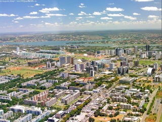
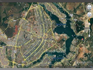
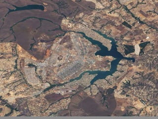
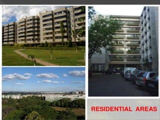
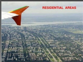
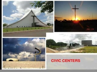
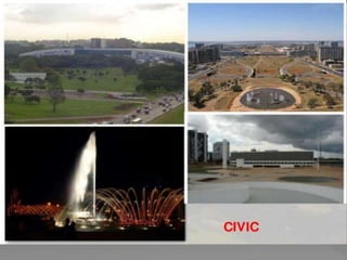
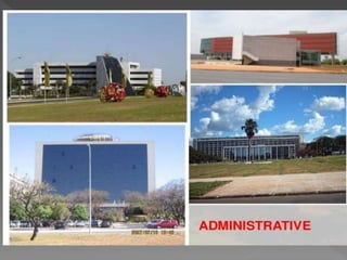
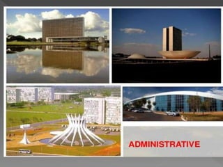
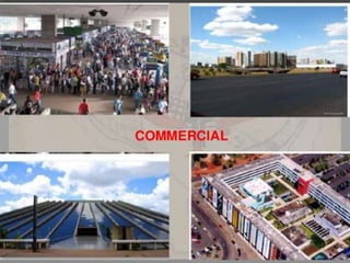
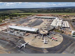
Brasilia is the purpose-built capital of Brazil, located in the center-west region. It was founded in 1960 to serve as a new, more centrally located capital instead of Rio de Janeiro. Brasilia has a planned, sector-based design and is a center of government, hosting the branches of the federal government and over 100 foreign embassies. While initially planned for 500,000 people, Brasilia's population has grown faster due to internal migration and now numbers over 2.5 million.
Brasilia - Urban City Planning - Human Settlement - UD YuktaYogeesh1
Brasilia | Urban City Planning | Human Settlement Planning | Settlement Pattern | History | Evolution | Concept | City Planning | Urban Form | Physical Layout | Master Plan | Land use map | Infrastructure | Population | Demographics | Road Network | Pros and Cons | Predicting Future Of Brasilia
Life and Career with works of Constantinos Apostolou Doxiadis. Theory of Urban Design presentation - CA Doxiadis : Ekistics theory, Islamabad master plan, Aspra Spitia introduction, Name of books and journals with bibliography
Singapore, officially the Republic of Singapore, is a sovereign island city-state in Southeast Asia.
It is located at the end of the Malayan Peninsula between Malaysia and Indonesia.
Singapore has a total land area of 724.2 square kilometers.
Singapore's territory consists of one main island along with 58 other islets.
Since independence[1965], extensive land reclamation has increased its total size by 23%.
Singapore is very small in size and confined. so, there every sq. meter matters.
Now, 90% of citizens in Singapore own their houses.
Urban planning in Singapore has formulated and guided its physical development from the day Singapore was founded in 1819 as a British colony to the developed, independent country it is today.
Urban planning is especially important due to land constraints and its high density.
The Urban Redevelopment Authority (URA) is Singapore's national land-use planning authority.
URA prepares long term strategic plans, as well as detailed local area plans, for physical development, and then co-ordinates and guides efforts to bring these plans to reality.
Prudent land use planning has enabled Singapore to enjoy strong economic growth and social cohesion, and ensures that sufficient land is safeguarded to support continued economic progress and future development
In 1822, Raffles initiated a comprehensive town plan called land use plan.
This plan to guide the allocation of land in the principal town to ensure that its physical growth followed an orderly pattern.
This became known as the Raffles Town Plan, or the Jackson Plan, drawn up by Lieutenant Philip Jackson and published in 1828.
Among its key features were a GRID LAYOUT for the road network and a clear segregation of residential communities by ethnic group (European, Chinese, Indian, Malay and Arab).
A separate area called Commercial Square (later renamed Raffles Place) was designated for commercial activities and another area was zoned for government functions.
Raffles Place and the street pattern of the city Centre
today are evidence of this colonial legacy.
PLANNING PRINCIPLES OF LE CORBUSIER – A CASE STUDY OF CHANDIGARH CITY”Yash Shah
The city has a pre-historic past. The gently sloping plains on which modern Chandigarh exists, was in the ancient past, a wide lake ringed by a marsh. The fossil remains found at the site indicate a large variety of aquatic and amphibian life, which was supported by that environment. About 8000 years ago the area was also known to be a home to the Harappans. Since the medieval through modern era, the area was part of the large and prosperous Punjab Province which was divided into East & West Punjab during partition of the country in 1947. The city was conceived not only to serve as the capital of East Punjab, but also to resettle thousands of refugees who had been uprooted from West Punjab. In March, 1948, the Government of Punjab, in consultation with the Government of India, approved the area of the foothills of the Shivaliks as the site for the new capital. The location of the city site was a part of the erstwhile Ambala district as per the 1892-93 gazetteer of District Ambala. The foundation stone of the city was laid in 1952. Subsequently, at the time of reorganization of the state on 01.11.1966 into Punjab, Haryana and Himachal Pardesh, the city assumed the unique distinction of being the capital city of both, Punjab and Haryana while it itself was declared as a Union Territory and under the direct control of the Central Government.
The Union Territory of Chandigarh is located in the foothills of the Shivalik hill ranges in the north, which form a part of the fragile Himalayan ecosystem. It is occupied by Kandi (Bhabhar) in the north east and Sirowal (Tarai) and alluvial plains in the remaining part. The subsurface formation comprises of beds of boulders, pebbles, gravel, sand, silt, clays and some kankar. The area is drained by two seasonal rivulets viz. Sukhna Choe in the east and Patiala-Ki-Rao Choe in the west. The central part forms a surface water divide and has two minor streams.
A technical approach to designing earthquake resistant buildings. Contains a brief overview of why a structure fails, building foundation problems and what are the possible solutions
This slide show depicts how rainwater harvesting has been accommodated in policy and legislation in India and specifically in the state of Karnataka. It gives example of projects in rural areas and in the city of Bangalore.
The term “Vernacular architecture” in general refers to the informal building of structures through traditional building methods without using the services of a professional architect. It is the most widespread form of building .
Vernacular architecture has been growing over time with continuities changes, transformations and adaptations to the different social and economic conditions of each period.
Earthquake resistant building constructiondaspriyabrata3
1 INTRODUCTION
2 EARTHQUAKE THEORY
3 EARTHQUAKE MAGNITUDE AND ENERGY
4 EFFECTS OF EARTHQUAKES
5 MAJOR EARTHQUAKES
6 NOTABLE EARTHQUAKES AND THEIR ESTIMATED
MAGNITUDE
7 HOW EARTHQUAKE RESISTANT CONSTRUCTION IS
DIFFERENT
8 SEISMIC DESIGN PHILOSOPHY
9 EFFECT OF EARTHQUAKE ON REINFORCED CONCRETE BUILDINGS
10 ROLES OF FLOOR AND MASONRY WALLS SLABS
11 STRENGTH HIERARCHY
12 EARTHQUAKE RESISTANT BUILDING
13 EARTHQUAKE DESIGN PHILOSOPHY
14 REMEDIAL MEASURES TO MINIMISE THE LOSSES DUE TO EARTHQUAKES
15 EARTHQUAKE RESISTANT BUILDING CONSTRUCTION WITH REINFORCED HOLLOW CONCRETE BLOCK(RHCBM)
16 STRUCTURAL FEATURES
17 STRUCTURAL ADVANTAGES
18 CONSTRUCTIONAL ADVANTAGES
19 ARCHITECTURAL AND OTHER ADVANTAGES
20 STUDIES ON THE COMPARATIVE COST ECONOMICS OF RHCBM
21 MID-LEVEL ISOLATION 32-34
22 EARTHQUAKE RESISTANCE BUILDING USING SEISMIC ISOLATION SYSTEMS WITH SLIDING ON CONCAVE SURFACE
23 DESCRIPTION
24 CONCEPT OF FRICTION PENDULUM BEARING
25 SLIDING PENDULUM SEISMIC ISOLATION SYSTEM
26 BACKGROUND OF THE INVENTION
27 BRIEF SUMMARY OF THE INVENTION
28 DETAILED DESCRIPTION OF THE INVENTION
29 ESTIMATION
30 CONCLUSION
31 BIBLIOGRAPHY
Introduction to Site Planning. These slides should be able to provide urban planners a simple guide to factors and issues to consider in planning a a site. These slides were prepared for urban design class for masters students in Makerere University Kampala ( Uganda)
Kevyn introduced a concept of planning that was the base for understanding and visualising The Planning Aspects; important for the budding planners.
The presentation initiates the same understanding and invokes a means for better understanding of 'Planning'.
The National Culture Day was instituted in Brazil by Federal Law No. 5,579, of May 19, 1970 celebrating the birth on November 5, 1849 by Ruy Barbosa, one of the most important characters in the history of Brazil. In addition to its immense lawyer capacity, Ruy stood out for its privileged intelligence. Ruy Barbosa demonstrated his intellectual fertility to meet legal opinions, literary essays, journalistic articles, legislative bills, drafts of territorial treaties and speeches, such as his famous Prayer to Young Men. Ruy Barbosa acted in defense of federalism, of abolitionism and of the promotion of individual rights and guarantees. He was 4 times candidate for president of Brazilian Republic, deputy, senator, minister of state and Machado de Assis's successor as president of the Brazilian Academy of Letters between 1908 and 1919. For all accomplished in his life, Ruy Barbosa is the biggest Brazilian of the story by a jury invited by Epoca magazine and in 2013 was chosen by a panel of 214 personalities from various fields made by the newspaper A Tarde as the biggest Bahian of all time.
Final project about how Brazilians entrepreneurs not only chose Somerville to launch their businesses but how the city has played a role in their development and growth. Additionally, the author explores how the Brazilian population in Somerville serves as a network for business owners and how they use its various channels to expand revenue and patronage
Concept Plan submitted by Renaissance Downtowns to City of Bristol, CT in April 2011, outlining the master plan for the redevelopment of downtown Bristol.
An analysis of the perspective of transformation of urban mobility in the city of Manaus, under a vision of the paradigms of intelligent city, presented by Cristóvam Luiz aiming to obtain a scholarship to participate in the IGLUS Executive Master Program, of the Polytechnic School of Lausanne.
Palestine last event orientationfvgnh .pptxRaedMohamed3
An EFL lesson about the current events in Palestine. It is intended to be for intermediate students who wish to increase their listening skills through a short lesson in power point.
How to Create Map Views in the Odoo 17 ERPCeline George
The map views are useful for providing a geographical representation of data. They allow users to visualize and analyze the data in a more intuitive manner.
How to Split Bills in the Odoo 17 POS ModuleCeline George
Bills have a main role in point of sale procedure. It will help to track sales, handling payments and giving receipts to customers. Bill splitting also has an important role in POS. For example, If some friends come together for dinner and if they want to divide the bill then it is possible by POS bill splitting. This slide will show how to split bills in odoo 17 POS.
This is a presentation by Dada Robert in a Your Skill Boost masterclass organised by the Excellence Foundation for South Sudan (EFSS) on Saturday, the 25th and Sunday, the 26th of May 2024.
He discussed the concept of quality improvement, emphasizing its applicability to various aspects of life, including personal, project, and program improvements. He defined quality as doing the right thing at the right time in the right way to achieve the best possible results and discussed the concept of the "gap" between what we know and what we do, and how this gap represents the areas we need to improve. He explained the scientific approach to quality improvement, which involves systematic performance analysis, testing and learning, and implementing change ideas. He also highlighted the importance of client focus and a team approach to quality improvement.
The French Revolution, which began in 1789, was a period of radical social and political upheaval in France. It marked the decline of absolute monarchies, the rise of secular and democratic republics, and the eventual rise of Napoleon Bonaparte. This revolutionary period is crucial in understanding the transition from feudalism to modernity in Europe.
For more information, visit-www.vavaclasses.com
Ethnobotany and Ethnopharmacology:
Ethnobotany in herbal drug evaluation,
Impact of Ethnobotany in traditional medicine,
New development in herbals,
Bio-prospecting tools for drug discovery,
Role of Ethnopharmacology in drug evaluation,
Reverse Pharmacology.
Unit 8 - Information and Communication Technology (Paper I).pdfThiyagu K
This slides describes the basic concepts of ICT, basics of Email, Emerging Technology and Digital Initiatives in Education. This presentations aligns with the UGC Paper I syllabus.
Model Attribute Check Company Auto PropertyCeline George
In Odoo, the multi-company feature allows you to manage multiple companies within a single Odoo database instance. Each company can have its own configurations while still sharing common resources such as products, customers, and suppliers.
2. Brasilia is the federal
capital of Brazil and seat of government of
the Federal District. The city is located atop
the Brazilian highlands in the country's center-
western region. It was founded on April 21, 1960,
to serve as the new national capital. Brasília and
its metro had a population of 2,556,149 in 2011,
making it the 4th most populous city in Brazil
Among major Latin American cities, Brasília has
the highest GDP per capita
at R$61,915 (US$36,175).
3.
4. From 1763 until 1960, Rio de Janeiro was the capital
of Brazil . Brasília's geographically central location
fostered a more regionally neutral federal capital. An
article of the country's first republican
constitution dating back to 1891 stated that the capital
should be moved from Rio de Janeiro to a place close
to the center of the country.
The plan was originally conceived in 1827 by José
Bonifácio, an advisor to Emperor Pedro I. He
presented a plan to the General Assembly of
Brazil for a new city called Brasília, with the idea of
moving the capital westward from the heavily
populated southeastern corridor
5. Juscelino Kubitschek, President of Brazil from
1956 to 1961, ordered the construction of Brasília
Building Brasília was part of Juscelino's "fifty
years of prosperity in five" plan. Lúcio Costa won
a contest and was the main urban planner in
1957. Oscar Niemeyer, a close friend, was the
chief architect of most public buildings
and Roberto Burle Marx was the landscape
designer. Brasília was built in 41 months, from
1956 to April 21, 1960, when it was officially
inaugurated
6.
7. Paranoá Lake is a large artificial lake built to
increase the amount of water available and the
humidity of the region. It has the second largest
marina in Brazil, and hosts wakeboarders and
windsurfers. Diving can also be practiced and one
of the main attractions is Vila Amaury, an old
village that is submerged in the lake. This is
where the first construction workers of Brasília
used to live
8.
9.
10. For new development
To relieve the pressure of overpopulated from the
old capital Rio De Janerio
In the 1960 census there were almost 140
thousand residents in the new Federal District
The city of Brasília proper was planned for only
about 500 thousand inhabitants, but its
metropolitan area has grown past this figure
11. Brasília would be a city for government
authorities and staff. However, during the
construction period, Brazilians from all over
the country migrated to Brasília, seeking
public and private jobs
At the close of the 20th century, Brasília held
the distinction of being the largest city in the
world which had not existed at the beginning
of the century
Brasília has one of the highest population
growth rates in Brazil, with annual growth of
2.82%, mostly due to internal migration.
12. The city's design divides it into numbered blocks as
well as sectors for specified activities, such as the
Hotel Sector, the Banking Sector and the Embassy
Sector. Brasília was chosen as a UNESCO World
Heritage Site due to its modernist architecture and
uniquely artistic urban planning. The centers of all
three branches of the federal government of
Brazil are in Brasília, including
the Congress, President, and Supreme Court. The
city also hosts 124 foreign embassies Brasília
International Airport connects the capital to all major
Brazilian cities and many international destinations,
and is the third busiest airport in Brazil
13.
14.
15.
16.
17.
18.
19.
20.
21. The major roles of construction and of services
(government, communications, banking , finance,
food production, entertainment, and legal
services) in Brasília's economy reflect the city's
status as a governmental rather than an industrial
center. Industries connected with construction,
food processing, and furnishings are important, as
are those associated with publishing, printing, and
computer software. GDP is divided in Public
Administration 54.8%, Services 28.7%, Industry
10.2%, Commerce 6.1%, Agribusiness 0.2%
22. Brasília has a tropical savanna climate according
to the Köppen system, with two distinct seasons:
the rainy season, from October to April, and a dry
season, from May to September. The average
temperature is 20.6 °C (69.1 °F). September, at
the end of the dry season. January is the month
with the highest rainfall of the year, while June is
the lowest, with only 8.7 mm