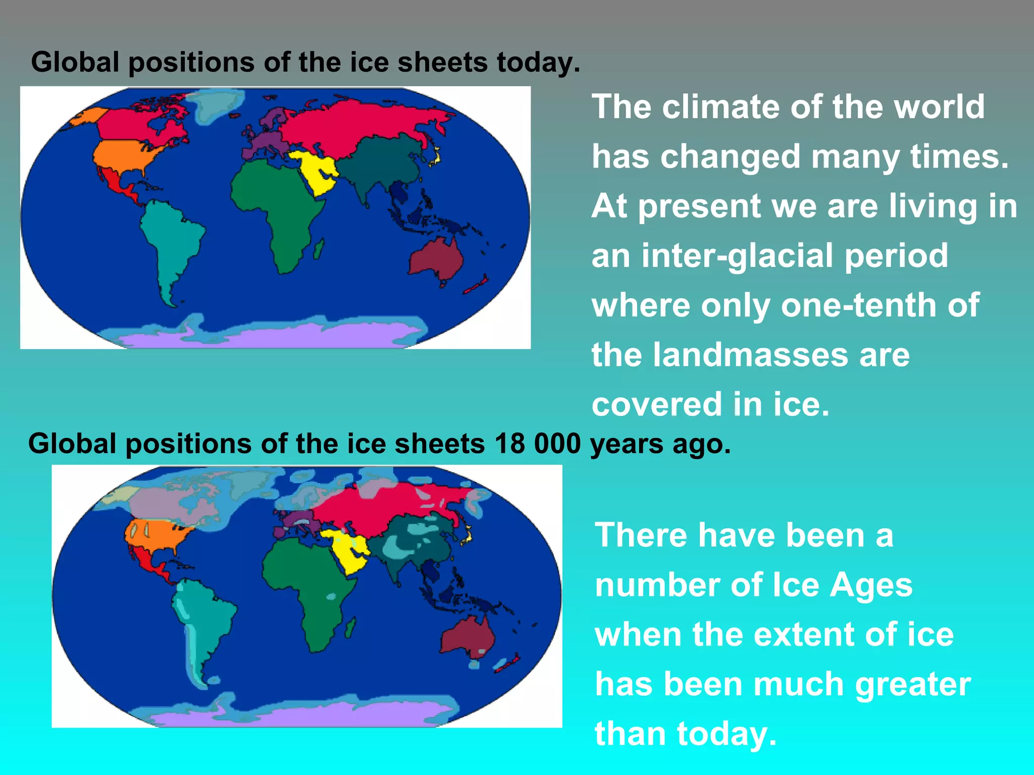
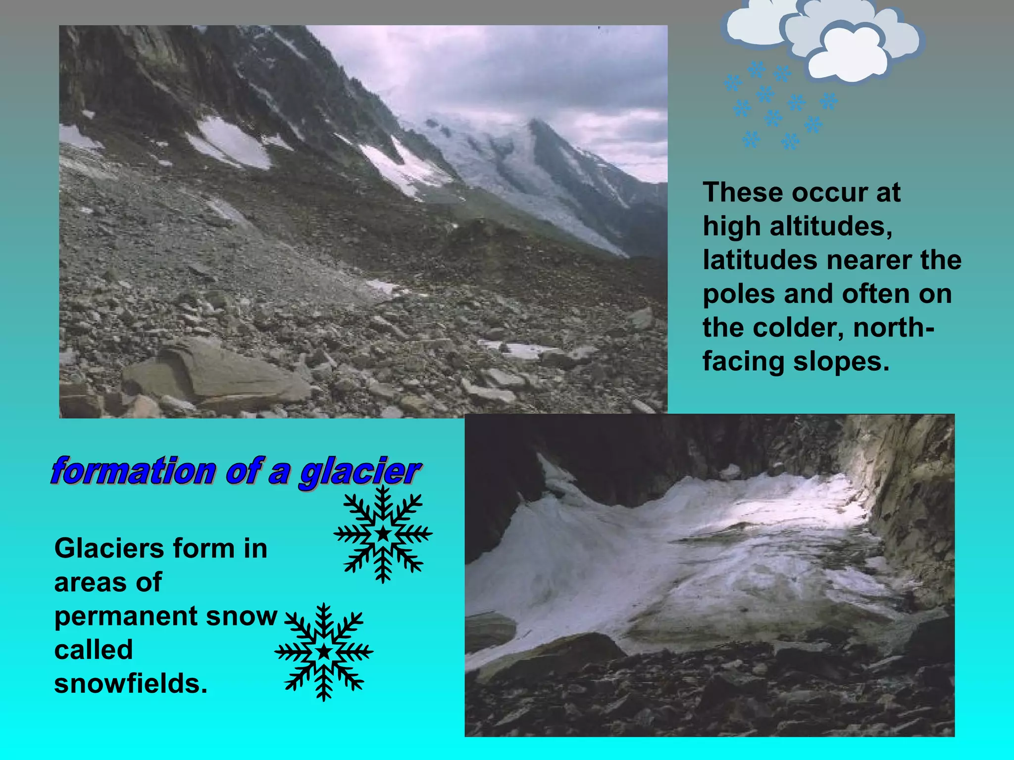
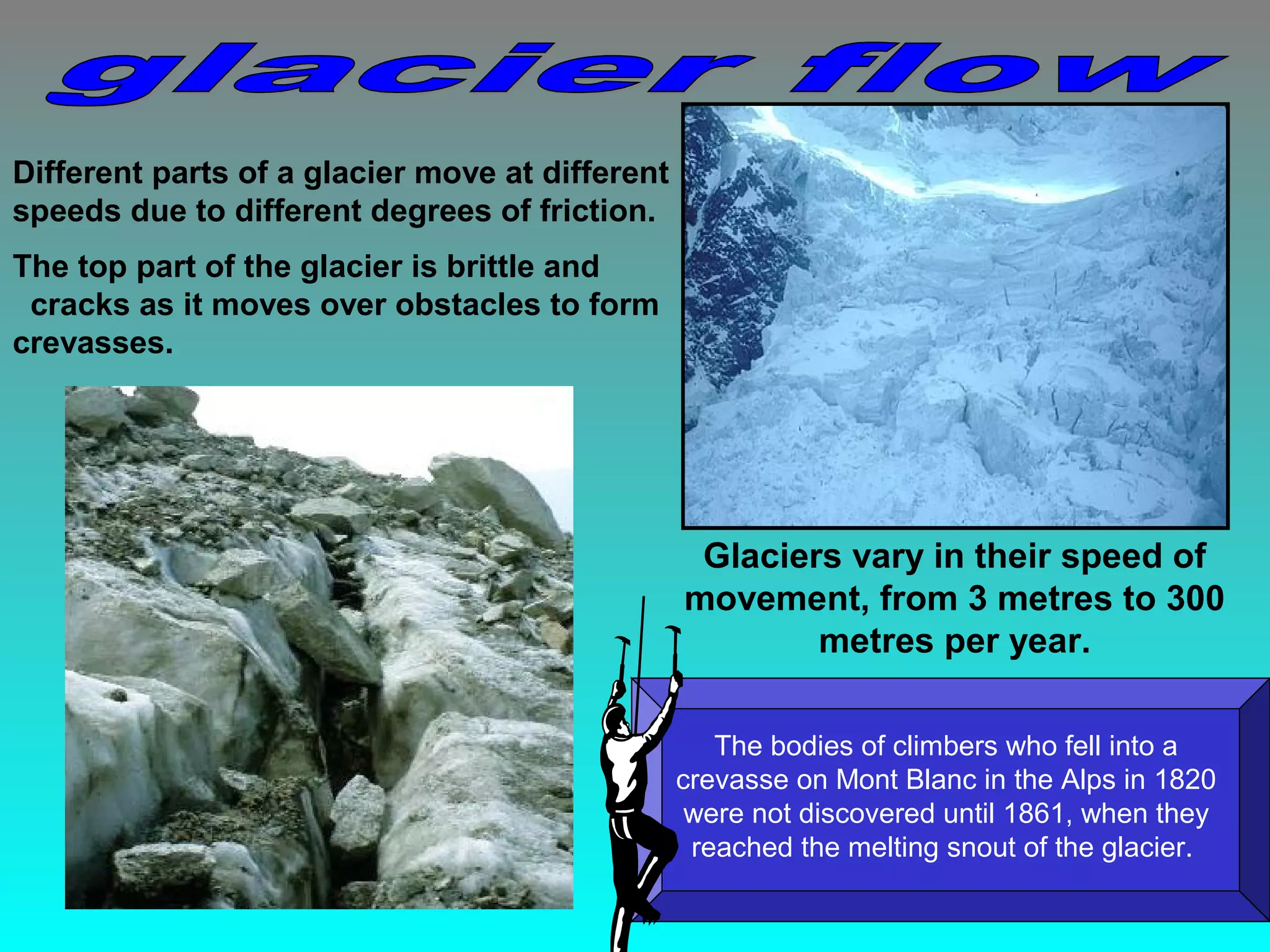
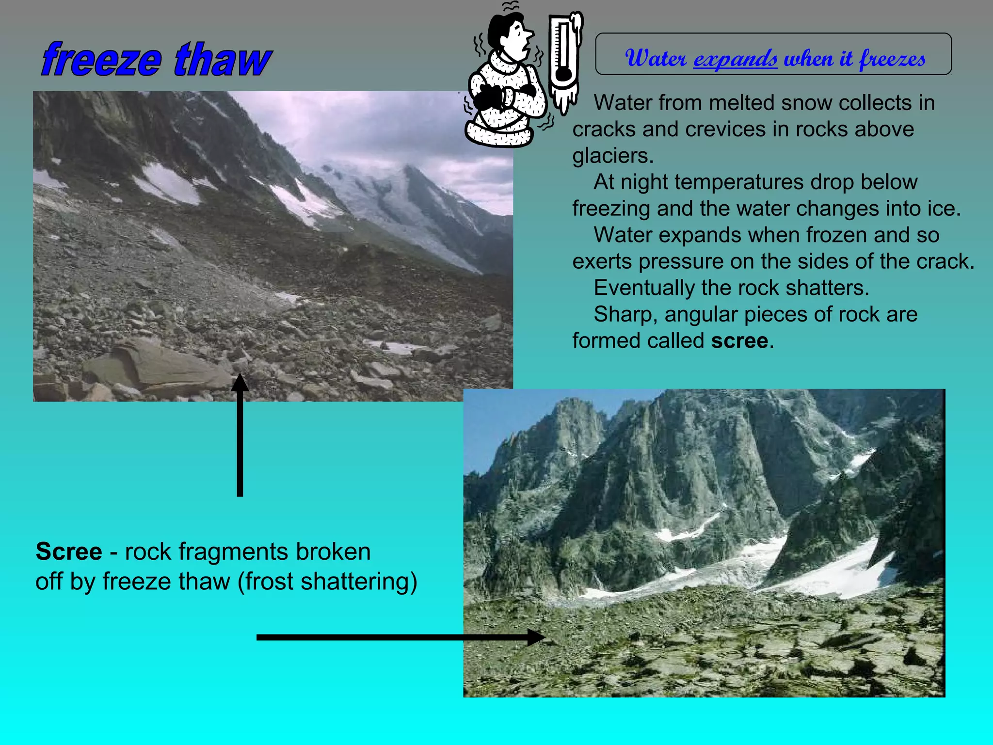
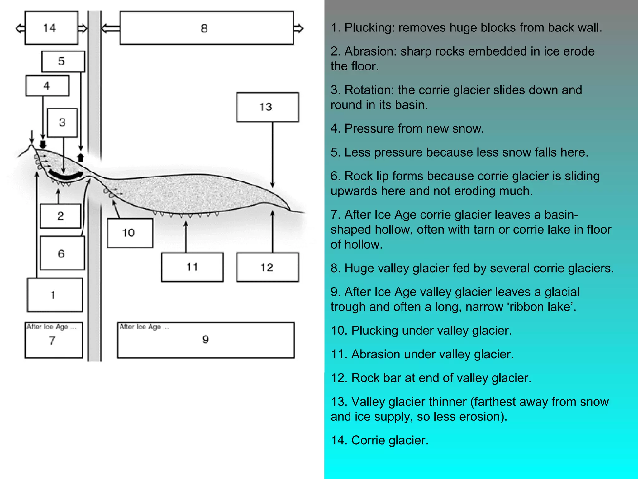
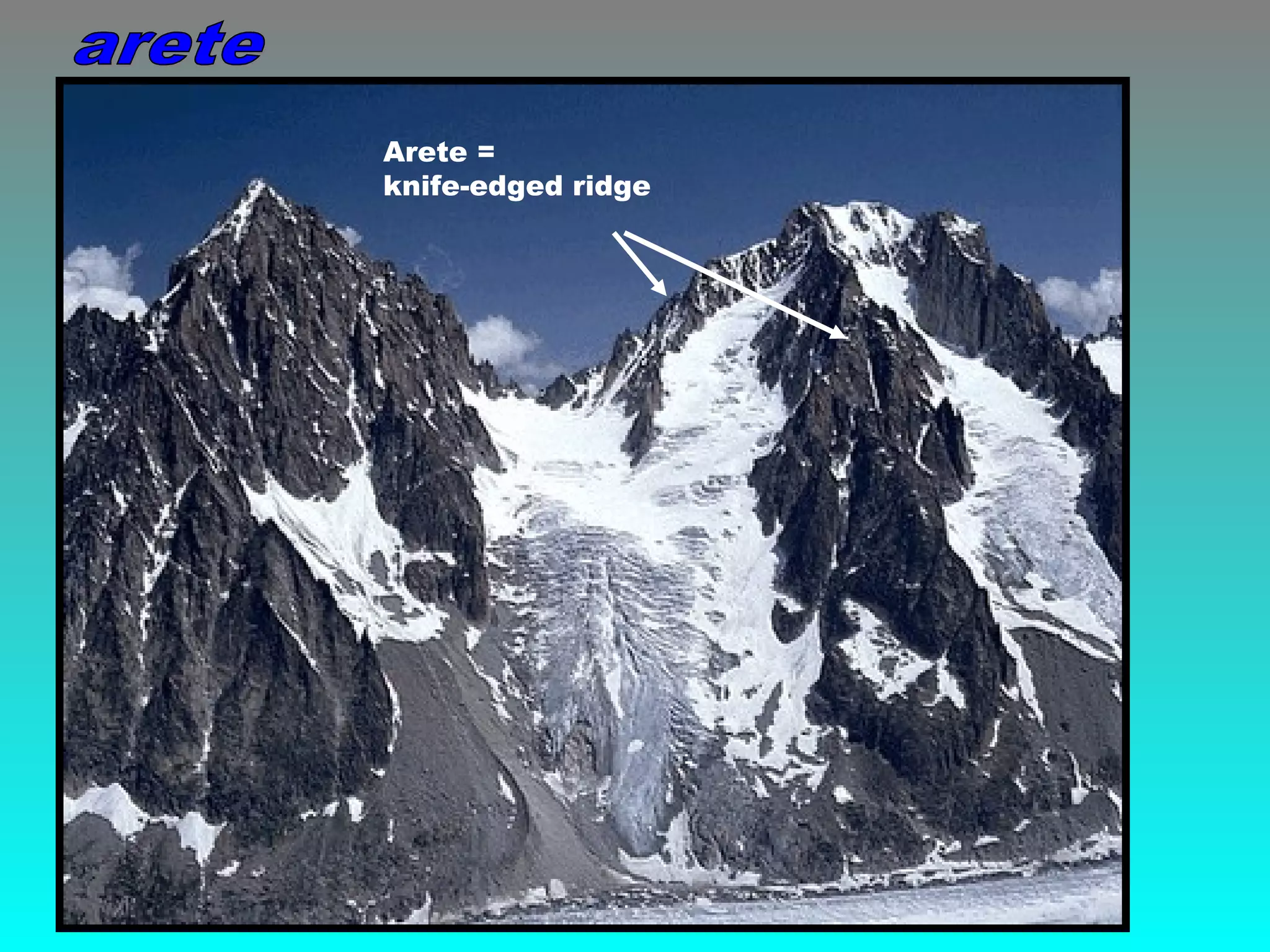
wind
water
waves
iceice
The climate of the world
has changed many times.
At present we are living in
an inter-glacial period
where only one-tenth of
the landmasses are
covered in ice.
Global positions of the ice sheets 18 000 years ago.
Global positions of the ice sheets today.
There have been a
number of Ice Ages
when the extent of ice
has been much greater
than today.
The ‘Ice Age’ was a series of advances and retreats of the icecaps.
It lasted from 1.7 million years to 10,000 years BP.
Most of Britain and northern Europe were glaciated as well as the
high mountain regions of the south of the continent.
Ice covered most of Britain as far
south as the Severn Thames line.
In some places the ice was over
a thousand metres thick. Severn Thames line
These occur at
high altitudes,
latitudes nearer the
poles and often on
the colder, north-
facing slopes.
Glaciers form in
areas of
permanent snow
called
snowfields.
 As more snow falls the
pressure makes the earlier
snowflakes melt.
 Repeated melting and re-
freezing forms granules called
firn or névé.
 Further compression forms
larger crystals of glacial ice.
 It can take 30 to 40 years for
snow to form dense glacial
ice.
 It now moves downslope
Despite being hard and solid, glacier ice flows
because of:
• internal deformation -
individual ice crystals within a
glacier deform and slide across
one another.
• basal sliding - meltwater at the base of
the glacier lubricates the ice causing it to
slide.
Different parts of a glacier move at different
speeds due to different degrees of friction.
The top part of the glacier is brittle and
cracks as it moves over obstacles to form
crevasses.
Glaciers vary in their speed of
movement, from 3 metres to 300
metres per year.
The bodies of climbers who fell into a
crevasse on Mont Blanc in the Alps in 1820
were not discovered until 1861, when they
reached the melting snout of the glacier.
3. Explain briefly how glaciers form and then begin to move.
1. List the 4 ‘AGENTS OF EROSION’ responsible for the
formation of landscapes.
2. List the 3 stages in the formation of new landscapes.
Ice erodes by:
1. Freeze Thaw (Frost Shattering)
Water in cracks in the rock freezes and expands.
After many cycles of freezing and thawing lumps of rock are
broken off.
2. Plucking
Glacier ice freezes into cracks in rocks and when the glacier
moves it pulls out chunks to leave a jagged surface.
3. Abrasion
Rocks stuck in the ice grind away the bedrock under the
glacier.
Scree - rock fragments broken
off by freeze thaw (frost shattering)
Water expands when it freezes
Water from melted snow collects in
cracks and crevices in rocks above
glaciers.
At night temperatures drop below
freezing and the water changes into ice.
Water expands when frozen and so
exerts pressure on the sides of the crack.
Eventually the rock shatters.
Sharp, angular pieces of rock are
formed called scree.
Glacial ice melts due to
friction as it goes over an
obstacle like a rock mass.
This water will almost
instantly refreeze because
of the overlying pressure
of the ice.
It re-freezes into the
cracks and crevices and
as the glacier moves loose
pieces of rock are pulled
or torn out.
This erosion process occurs when pieces of rock debris
embedded in the ice wear away the rocks on the valley
floor and sides.
When two glaciers meet stripes of
medial (middle) moraine is formed
Lateral moraine
is found along
the valley sides
The rock is scratched, polished, smoothed and eventually worn away by the
scouring action.
The pieces of rock also become smaller through this rubbing action.
Striations
Striations are scratches made on the existing surface by rocks that are embedded
in the bottom of the glacier as it moves forward.
2. Identify the feature shown on the
map and explain how it was formed.
Freeze-thaw is a WEATHERING process.
Plucking and abrasion are processes of EROSION.
1. Explain each of the three processes using diagrams and notes.
Snow collects in hollows, especially on the less sunny north and east facing
slopes, turns to glacial ice and moves downwards under the force of gravity
Rocks are plucked out and the hollow is widened to become a cirque or corrie.
A corrie is a deep, rounded hollow with a steep head or back wall.
a) snow collects in hollows
b) snow compacts to ice
c) ice moves under gravity, lubricated by meltwater
d) ice rotates to lip
e) abrasion deepens corrie
f) plucking steepens back and sides
g) corrie lochan (tarn) may fill hollow.
Position photograph
taken from
Position photograph
taken from
Once the glacier retreats, the cirque may be filled with water. A small,
generally circular loch is formed. This is known as a tarn or corrie lochan.
1. Plucking: removes huge blocks from back wall.
2. Abrasion: sharp rocks embedded in ice erode
the floor.
3. Rotation: the corrie glacier slides down and
round in its basin.
4. Pressure from new snow.
5. Less pressure because less snow falls here.
6. Rock lip forms because corrie glacier is sliding
upwards here and not eroding much.
7. After Ice Age corrie glacier leaves a basin-
shaped hollow, often with tarn or corrie lake in floor
of hollow.
8. Huge valley glacier fed by several corrie glaciers.
9. After Ice Age valley glacier leaves a glacial
trough and often a long, narrow ‘ribbon lake’.
10. Plucking under valley glacier.
11. Abrasion under valley glacier.
12. Rock bar at end of valley glacier.
13. Valley glacier thinner (farthest away from snow
and ice supply, so less erosion).
14. Corrie glacier.
Add the correct number to each of the
boxes in the diagram on your worksheets
An arete is a narrow, sharp-edged ridge which forms the side walls
of cirques and separates different glacial valleys.
Aiguille du Midi
Arete =
knife-edged ridge
a) three or more corries form around a peak
b) where corrie sidewalls meet they form an arête (knife edge).
c) arêtes meet to form a horn (pyramidal peak).
horn =
pyramidal peak
When three or more
corries erode backwards
a sharp pointed pyramid
shape is created.
This is called a Pyramidal
Peak or Horn.
Matterhorn
1. Write a definition of each of the following terms:-
corriecorrie
arêtearête
hornhorn
tarntarn
2. Which feature goes with which
letter on the diagram?
a)a)
b)b)
c)c)
d)d)
Red Tarn
Helvellyn
Lake District
When a corrie is formed, its back and side walls are
steep. When two corries form next to each other a
narrow rock ridge is formed. This is often likened to a
knife edge, with near vertical sides and a sharp top
edge.
This feature is called an arête or knife-edged ridge.
Striding Edge
Helvellyn
Lake District
Striding Edge
Striding Edge
Helvellyn
Lake District
Striding Edge
Swirral Edge
Helvellyn
Lake District
Catstye Cam
Helvellyn
Lake District
Swirral Edge
Catstye Cam
scree arêtetarncirque
Identify examples of glacial features on the map.
a) glacier flows in an earlier 'V' shaped valley,
b) glacier abrades the sides and floor of the river valley,
c) valley is greatly deepened, widened and straightened,
d) when the ice melts the valley is 'U' shaped,
e) it has very steep sides and a fairly flat floor,
f) any later rivers are called 'misfit streams’ because they are far too small to
have cut the valley.
Describe the main
features of a glaciated
U-shaped valley
and its ‘misfit’ river.
Glaciers are very powerful agents of erosion: they reshape former V-shaped river valleys
into wide, deep, steep-sided troughs by the processes of abrasion and plucking.
Former river spurs are truncated: their ends are cut off by the ice action to
form steep, sheer cliffs.
truncated spur
terminal moraine
spur
spur
spur
Interlocking spurs
V-shaped valley
valley glacier
U-shaped valley
When a glaciated valley is submerged or
drowned by a rise in sea level a fiord is
formed.
The sea lochs of western Scotland are
the best examples of fiords in the British
Isles.
Sognefjord Norway
Vertical erosion in the main glacier is far
greater than in the tributary glaciers.
Valleys are not the same depth and
after the glacier has retreated rivers
flowing down the tributary join the main
trough via a waterfall
Position photograph
taken from
At the base of a waterfall alluvial fans are
sometimes found as a result of deposition.
Lauterbrunnen
Switzerland
alluvium = silt deposited by a river
V-shaped
valley
U-shaped
valley
hanging
valley
waterfall
When a glacier moves along its valley some parts are deepened more than others.
When the glacier retreats the deepened sections fill with melt water and become lakes.
The English Lake district owes its character to these narrow ribbon lakes along its
valley floors.
Ullswater
Lake District
Haweswater
Lake District
Ribbon lakes can also be formed when
glacial deposits build a natural barrier
across a glacial trough

Glacial Erosion

  • 2.
  • 4.
    The climate ofthe world has changed many times. At present we are living in an inter-glacial period where only one-tenth of the landmasses are covered in ice. Global positions of the ice sheets 18 000 years ago. Global positions of the ice sheets today. There have been a number of Ice Ages when the extent of ice has been much greater than today.
  • 5.
    The ‘Ice Age’was a series of advances and retreats of the icecaps. It lasted from 1.7 million years to 10,000 years BP. Most of Britain and northern Europe were glaciated as well as the high mountain regions of the south of the continent.
  • 6.
    Ice covered mostof Britain as far south as the Severn Thames line. In some places the ice was over a thousand metres thick. Severn Thames line
  • 8.
    These occur at highaltitudes, latitudes nearer the poles and often on the colder, north- facing slopes. Glaciers form in areas of permanent snow called snowfields.
  • 9.
     As moresnow falls the pressure makes the earlier snowflakes melt.  Repeated melting and re- freezing forms granules called firn or névé.  Further compression forms larger crystals of glacial ice.  It can take 30 to 40 years for snow to form dense glacial ice.  It now moves downslope
  • 10.
    Despite being hardand solid, glacier ice flows because of: • internal deformation - individual ice crystals within a glacier deform and slide across one another. • basal sliding - meltwater at the base of the glacier lubricates the ice causing it to slide.
  • 11.
    Different parts ofa glacier move at different speeds due to different degrees of friction. The top part of the glacier is brittle and cracks as it moves over obstacles to form crevasses. Glaciers vary in their speed of movement, from 3 metres to 300 metres per year. The bodies of climbers who fell into a crevasse on Mont Blanc in the Alps in 1820 were not discovered until 1861, when they reached the melting snout of the glacier.
  • 13.
    3. Explain brieflyhow glaciers form and then begin to move. 1. List the 4 ‘AGENTS OF EROSION’ responsible for the formation of landscapes. 2. List the 3 stages in the formation of new landscapes.
  • 14.
    Ice erodes by: 1.Freeze Thaw (Frost Shattering) Water in cracks in the rock freezes and expands. After many cycles of freezing and thawing lumps of rock are broken off. 2. Plucking Glacier ice freezes into cracks in rocks and when the glacier moves it pulls out chunks to leave a jagged surface. 3. Abrasion Rocks stuck in the ice grind away the bedrock under the glacier.
  • 15.
    Scree - rockfragments broken off by freeze thaw (frost shattering) Water expands when it freezes Water from melted snow collects in cracks and crevices in rocks above glaciers. At night temperatures drop below freezing and the water changes into ice. Water expands when frozen and so exerts pressure on the sides of the crack. Eventually the rock shatters. Sharp, angular pieces of rock are formed called scree.
  • 16.
    Glacial ice meltsdue to friction as it goes over an obstacle like a rock mass. This water will almost instantly refreeze because of the overlying pressure of the ice. It re-freezes into the cracks and crevices and as the glacier moves loose pieces of rock are pulled or torn out.
  • 17.
    This erosion processoccurs when pieces of rock debris embedded in the ice wear away the rocks on the valley floor and sides. When two glaciers meet stripes of medial (middle) moraine is formed Lateral moraine is found along the valley sides
  • 18.
    The rock isscratched, polished, smoothed and eventually worn away by the scouring action. The pieces of rock also become smaller through this rubbing action.
  • 19.
    Striations Striations are scratchesmade on the existing surface by rocks that are embedded in the bottom of the glacier as it moves forward.
  • 20.
    2. Identify thefeature shown on the map and explain how it was formed. Freeze-thaw is a WEATHERING process. Plucking and abrasion are processes of EROSION. 1. Explain each of the three processes using diagrams and notes.
  • 21.
    Snow collects inhollows, especially on the less sunny north and east facing slopes, turns to glacial ice and moves downwards under the force of gravity Rocks are plucked out and the hollow is widened to become a cirque or corrie. A corrie is a deep, rounded hollow with a steep head or back wall.
  • 23.
    a) snow collectsin hollows b) snow compacts to ice c) ice moves under gravity, lubricated by meltwater d) ice rotates to lip e) abrasion deepens corrie f) plucking steepens back and sides g) corrie lochan (tarn) may fill hollow.
  • 24.
  • 25.
  • 26.
    Once the glacierretreats, the cirque may be filled with water. A small, generally circular loch is formed. This is known as a tarn or corrie lochan.
  • 27.
    1. Plucking: removeshuge blocks from back wall. 2. Abrasion: sharp rocks embedded in ice erode the floor. 3. Rotation: the corrie glacier slides down and round in its basin. 4. Pressure from new snow. 5. Less pressure because less snow falls here. 6. Rock lip forms because corrie glacier is sliding upwards here and not eroding much. 7. After Ice Age corrie glacier leaves a basin- shaped hollow, often with tarn or corrie lake in floor of hollow. 8. Huge valley glacier fed by several corrie glaciers. 9. After Ice Age valley glacier leaves a glacial trough and often a long, narrow ‘ribbon lake’. 10. Plucking under valley glacier. 11. Abrasion under valley glacier. 12. Rock bar at end of valley glacier. 13. Valley glacier thinner (farthest away from snow and ice supply, so less erosion). 14. Corrie glacier. Add the correct number to each of the boxes in the diagram on your worksheets
  • 28.
    An arete isa narrow, sharp-edged ridge which forms the side walls of cirques and separates different glacial valleys. Aiguille du Midi
  • 29.
  • 30.
    a) three ormore corries form around a peak b) where corrie sidewalls meet they form an arête (knife edge). c) arêtes meet to form a horn (pyramidal peak).
  • 31.
  • 32.
    When three ormore corries erode backwards a sharp pointed pyramid shape is created. This is called a Pyramidal Peak or Horn. Matterhorn
  • 33.
    1. Write adefinition of each of the following terms:- corriecorrie arêtearête hornhorn tarntarn 2. Which feature goes with which letter on the diagram? a)a) b)b) c)c) d)d)
  • 34.
  • 35.
    When a corrieis formed, its back and side walls are steep. When two corries form next to each other a narrow rock ridge is formed. This is often likened to a knife edge, with near vertical sides and a sharp top edge. This feature is called an arête or knife-edged ridge. Striding Edge Helvellyn Lake District Striding Edge
  • 36.
  • 37.
    Swirral Edge Helvellyn Lake District CatstyeCam Helvellyn Lake District Swirral Edge Catstye Cam
  • 38.
    scree arêtetarncirque Identify examplesof glacial features on the map.
  • 39.
    a) glacier flowsin an earlier 'V' shaped valley, b) glacier abrades the sides and floor of the river valley, c) valley is greatly deepened, widened and straightened, d) when the ice melts the valley is 'U' shaped, e) it has very steep sides and a fairly flat floor, f) any later rivers are called 'misfit streams’ because they are far too small to have cut the valley.
  • 40.
    Describe the main featuresof a glaciated U-shaped valley and its ‘misfit’ river.
  • 41.
    Glaciers are verypowerful agents of erosion: they reshape former V-shaped river valleys into wide, deep, steep-sided troughs by the processes of abrasion and plucking.
  • 42.
    Former river spursare truncated: their ends are cut off by the ice action to form steep, sheer cliffs.
  • 45.
    truncated spur terminal moraine spur spur spur Interlockingspurs V-shaped valley valley glacier U-shaped valley
  • 46.
    When a glaciatedvalley is submerged or drowned by a rise in sea level a fiord is formed. The sea lochs of western Scotland are the best examples of fiords in the British Isles. Sognefjord Norway
  • 47.
    Vertical erosion inthe main glacier is far greater than in the tributary glaciers. Valleys are not the same depth and after the glacier has retreated rivers flowing down the tributary join the main trough via a waterfall
  • 48.
  • 49.
    At the baseof a waterfall alluvial fans are sometimes found as a result of deposition. Lauterbrunnen Switzerland
  • 50.
    alluvium = siltdeposited by a river
  • 51.
  • 52.
    When a glaciermoves along its valley some parts are deepened more than others. When the glacier retreats the deepened sections fill with melt water and become lakes. The English Lake district owes its character to these narrow ribbon lakes along its valley floors. Ullswater Lake District
  • 53.
    Haweswater Lake District Ribbon lakescan also be formed when glacial deposits build a natural barrier across a glacial trough