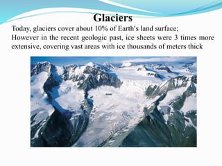
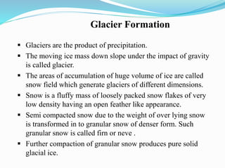
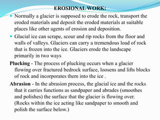
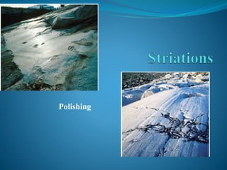
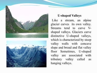
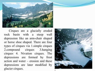
By
Dr.C.Karthikeyan,
Assistant Professor,
Department of Earth Sciences,
Annamalai University.
Glaciers
Today, glaciers cover about 10% of Earth’s land surface;
However in the recent geologic past, ice sheets were 3 times more
extensive, covering vast areas with ice thousands of meters thick
•Glaciers are part of two fundamental cycles in the Earth System, the
hydrologic cycle and the rock cycle
•When precipitation falls at high elevation or in a cold climate,
the water can become stored in a glacier as ice for hundreds,
thousands, even millions of years
•During the time that the water is locked up in a glacier as ice, it can
behave as a powerful erosion force.
•A glacier is a thick ice mass that originates on land from the
accumulation, compaction, and recrystallization of snow.
Glacier Formation
 Glaciers are the product of precipitation.
 The moving ice mass down slope under the impact of gravity
is called glacier.
 The areas of accumulation of huge volume of ice are called
snow field which generate glaciers of different dimensions.
 Snow is a fluffy mass of loosely packed snow flakes of very
low density having an open feather like appearance.
 Semi compacted snow due to the weight of over lying snow
is transformed in to granular snow of denser form. Such
granular snow is called firn or neve .
 Further compaction of granular snow produces pure solid
glacial ice.
Once the accumulated thickness of the ice exceeds 50
meters (160 feet), it is gradually transformed into a compact
solid mass of interlocking ice crystals. This conversion of
snow into glacial ice can take only a few seasons or
thousands of years depending on the climate and amount of
snowfall.
TYPES OF GLACIERS:
Glaciers are divided into two major types on the basis of size and
occurrence
Alpine glaciers are also known as mountain or valley glaciers
Continental glaciers are also known as ice caps or ice sheets.
Alpine glaciers
Alpine glaciers occupy valleys in mountainous terrain, most
often at relatively high elevations
They are the most common type of glaciers
It is estimated that there are about 67,000 alpine glaciers world-
wide
Continental glaciers
Continental glaciers commonly occur on plains and
relatively flat terrain.
They are categorized by size.
Ice caps generally cover less than 50,000 square kilometers.
Ice sheets are larger and can cover entire continents and reach
thicknesses of over a kilometer.
MOVEMENT OF GLACIERS
Glaciers moves under the impact of the force of
gravity which is the result of the thickness of ice mass
and the gradient of the bed. There are three types of
movement of glaciers
1. By sliding over bed rock
2. By internal deformation of the ice and
3. by alternate compression and extension of the ice
mass
EROSIONAL WORK:
 Normally a glacier is supposed to erode the rock, transport the
eroded materials and deposit the eroded materials at suitable
places like other agents of erosion and deposition.
 Glacial ice can scrape, scour and rip rocks from the floor and
walls of valleys. Glaciers can carry a tremendous load of rock
that is frozen into the ice. Glaciers erode the landscape
primarily in two ways
Plucking - The process of plucking occurs when a glacier
flowing over fractured bedrock surface, loosens and lifts blocks
of rock and incorporates them into the ice .
Abrasion - In the abrasion process, the glacial ice and the rocks
that it carries functions as sandpaper and abrades (smoothes
and polishes) the surface that the glacier is flowing over.
(Rocks within the ice acting like sandpaper to smooth and
polish the surface below.)
•The process of plucking occurs when a glacier flowing
over fractured bedrock surface, loosens and lifts blocks of
rock and incorporates them into the ice.
•In the abrasion process, the glacial ice and the rocks that
it carries functions as sandpaper and abrades (smoothes
and polishes) the surface that the glacier is flowing over.
Polishing
U-shaped Valleys
Like a stream, an alpine
glacier carves its own valley.
Streams tend to carve V-
shaped valleys. Glaciers carve
distinctive U-shaped valleys,
which is characterized by steep
valley walls with concave
slope and broad and flat valley
floor Sometimes, U-shaped
valley are associated with
tributary valley called as
hanging valleys.
Cirques are a glacially eroded
rock basin with a steep wall
depression like an arm-chair shaped
or horse shoe shaped. There are four
types of cirques via 1.simple cirques
2.compound cirques 3.hanging
cirques 4. Nivation cirques. The
depressions are formed by frost
action and water – erosion and these
depressions are later modified by
glacier cirques.
Tarn
After deglaciation the rock
basin of the cirque is filled up
with water and thus forms a
small glacier lake which is
called as cirque lake or a tarn.
Horns
A pyramidal or triangular-
faceted peak formed due to
recession and intersection of
three or more cirques is called
horn.
Arétes
The hillside between two flowing
glaciers can eroded and thinned to a
sharp ridge, called an aréte
Fiords
•Fiords are deep, often spectacular,
steep-side inlets of the sea
•They occur in cold climates where
mountains are adjacent to the ocean
 TRANSPORATION &DEPOSITIONAL WORK OF GLACIERS-
The rock debris carried by the glaciers is collectively called
glacial drifts. The debris transported by the glaciers are called moraine
and also are the landforms deposited by direct glacial origin. The
glacial debris is divided in to 3types on the basis of location i.e.
1. Englacial debris, which is transported within the glacier
2.Superglacial debris, which exists on the surface of the glacier and
3. Sub glacial debris, which is found at the base of the glacier
Glacial sediments are transported along the sides, floor and
snout of the glacier.
 DEPOSITIONAL LANDFORMS:
Depositional landform formed due to settling down of glacial
sediment of varying size includes moraines and drumlins.
 MORAINES
Moraines are ridge-like depositional features of glacial tills or
glacial sediment. They are long but narrow ridges with height more
than 30m . Moraines are generally divided in to 4 main categories on
the basis of locational aspect of glacial deposits via 1. End or terminal
moraines. 2. Lateral moraines. 3. Medial moraines and 4.ground
moraines.
Terminal moraines, also known as end
moraines are formed due to deposition of
glacial till across the moving ice sheet at
the snout of glaciers after ablation of ice.
Terminal moraines are horse shoe shaped
or crescentic ridges having concave
slopes facing glacial valleys. They stretch
for hundred of kilometers in length and
more than 100 meters in height
LATERAL MORAINES: are parallel
ridges of till on either side of a glacier.
They are formed due to deposition of
sediments along the margins of a glacier
when it contracts in size due to melting of
ice. Lateral moraines are generally long,
narrow and steep sided ridges parallel to
the glacial valleys. They are several
hundred meters in height.
 MEDIAL MORAINES: are formed due to deposition of
glacial sediments along the internal margins of two glacier of
their confluence. They project above the surface of glacial
valley.
 GROUND MORAINES: are formed when glacial sediments
are deposited at the floor of glacial valleys. The sediments are
not sorted because coarse and fine sediments are deposited
together.
 DRUMILNS: The swarms of rounded hummocks resulting
from the deposition of glacial tills are called drumlins. They
look like an inverted boat or spoon. Drumlins are elliptical or
ovoid hills blunt on the up glacier end (steeper slope) with an
elongate down glacier tail. These are streamlined hills which
vary in size ranging from a few meters to 100metres in height
and from a few hundred meters to one kilometer in length.
Usually, they occur in cluster and regular pattern. Such
topography is called ‘basket of egg topography’. Drumlins
resemble roches moutonnees in shape.
Medial
moraine
GLACIO FLUVIAL DEPOSITS AND LANDFORMS:
 The snout of a glacier starts melting due to increase in
temperature when it descends below snowline. The process of
melting of a glacier is called ablation.
 Melt water escape through numerous but small and temporary
streams. These streams carry sediments for longer distances
and deposit them in various forms. These streams still carry
some ice. Thus the deposition of sediments after the ablation of
a glacier is called glacio-fluvial deposit and the landforms from
deposits are called glacio-fluvial landforms.
 The sediments are deposited in the form of low alluvial fans
(on land) a deltas (in standing water).The fans spread out and
coalescein to plains called as outwash plain. The glaciofluvial
landforms include eskers, kames, kame terrace, kettle, kettle
holes, out wash plains etc…
 ESKER:
Eskers are long, narrow and sinuous ridges of sands and
gravels and are situated in the middle of ground moraine. The
sides of eskers are very steep. They vary in height and width in
the range of tens of meter and extend in length for kilometer.
They are extended through valley, lakes and undulating terrains
and thus they are very useful from the point of transportation as
roads are easily constructed along eskers. Some times a series of
swellings are strong along the eskers at regular intervals. Such
eskers are called beaded eskers.
 KAMES:
Kames are small hills or irregular mounds of bedded
sands and gravels which are deposited by melt water near or at
the edges of the retreating ice sheets. They are, in fact, small
alluvial cones if deposited in the land or small alluvial deltas if
deposited in the lakes. So kames are classified in to cone kames
and delta kames.
 They are characterized by steep side slopes. Narrow
flat topped terrace like ridges formed along the trough
between the glacier and the valley side are called
kames terraces.
 KETTLES&HUMMOCKS: Kettles are depressions in
the out wash plains. Kettles are formed due to melting of
large block of ice. Large kettle is dotted with numerous
low mounds which are called hummocks.
 OUT WASH: The melt water caused due to ablation of a
glacier at its snout descends through the terminal moraine
and spreads like sheet water. This spreading water eroded
the terminal moraine and deposits the eroded sediments in
front of the terminal moraine and thus form a plain called
out wash plain.
Kame
ESKER:
Eskers are long, narrow and sinuous ridges of sands
and gravels and are situated in the middle of ground
moraine. The sides of eskers are very steep. They vary in
height and width in the range of tens of meter and extend in
length for kilometer. They are extended through valley, lakes
and undulating terrains and thus they are very useful from
the point of transportation as roads are easily constructed
along eskers. Some times a series of swellings are strong
along the eskers at regular intervals. Such eskers are called
beaded eskers.
KAMES:
Kames are small hills or irregular mounds of
bedded sands and gravels which are deposited by melt water
near or at the edges of the retreating ice sheets. They are, in
fact, small alluvial cones if deposited in the land or small
alluvial deltas if deposited in the lakes. So kames are
classified in to cone kames and delta kames. They are
characterized by steep side slopes. Narrow flat topped
terrace like ridges formed along the trough between the
glacier and the valley side are called kames terraces.
Glaciers of the Past
• Late Cenozoic (Plio-Pleistocene) Ice Age
•Ice sheets have periodically built up, covering up
to 30% of the total land surface, over the last 2.4
million years.
• Number of Glaciations:
• Pliocene – At least two
• Pleistocene – At least nine, including:
Four major stages recognized in North America:
• Nebraskan
• Kansan
• Illinoian
• Wisconsinan
Causes of Glaciation
Some Possible Causes of Glaciation:
• Plate Tectonics
•Continents were arranged differently in the Past
• Changes in oceanic circulation
• Variations in Solar Output (sunspots)
• Higher values of radiation are associated with more
sunspots.
• Variations in Atmospheric Greenhouse Gases (water,
methane, carbon dioxide)
• Variations in Earth’s Orbit and Tilt
Thank you

Glacier formation and landforms

  • 1.
    By Dr.C.Karthikeyan, Assistant Professor, Department ofEarth Sciences, Annamalai University.
  • 2.
    Glaciers Today, glaciers coverabout 10% of Earth’s land surface; However in the recent geologic past, ice sheets were 3 times more extensive, covering vast areas with ice thousands of meters thick
  • 3.
    •Glaciers are partof two fundamental cycles in the Earth System, the hydrologic cycle and the rock cycle •When precipitation falls at high elevation or in a cold climate, the water can become stored in a glacier as ice for hundreds, thousands, even millions of years •During the time that the water is locked up in a glacier as ice, it can behave as a powerful erosion force. •A glacier is a thick ice mass that originates on land from the accumulation, compaction, and recrystallization of snow.
  • 4.
    Glacier Formation  Glaciersare the product of precipitation.  The moving ice mass down slope under the impact of gravity is called glacier.  The areas of accumulation of huge volume of ice are called snow field which generate glaciers of different dimensions.  Snow is a fluffy mass of loosely packed snow flakes of very low density having an open feather like appearance.  Semi compacted snow due to the weight of over lying snow is transformed in to granular snow of denser form. Such granular snow is called firn or neve .  Further compaction of granular snow produces pure solid glacial ice.
  • 5.
    Once the accumulatedthickness of the ice exceeds 50 meters (160 feet), it is gradually transformed into a compact solid mass of interlocking ice crystals. This conversion of snow into glacial ice can take only a few seasons or thousands of years depending on the climate and amount of snowfall.
  • 6.
    TYPES OF GLACIERS: Glaciersare divided into two major types on the basis of size and occurrence Alpine glaciers are also known as mountain or valley glaciers Continental glaciers are also known as ice caps or ice sheets.
  • 7.
    Alpine glaciers Alpine glaciersoccupy valleys in mountainous terrain, most often at relatively high elevations They are the most common type of glaciers It is estimated that there are about 67,000 alpine glaciers world- wide Continental glaciers Continental glaciers commonly occur on plains and relatively flat terrain. They are categorized by size. Ice caps generally cover less than 50,000 square kilometers. Ice sheets are larger and can cover entire continents and reach thicknesses of over a kilometer.
  • 8.
    MOVEMENT OF GLACIERS Glaciersmoves under the impact of the force of gravity which is the result of the thickness of ice mass and the gradient of the bed. There are three types of movement of glaciers 1. By sliding over bed rock 2. By internal deformation of the ice and 3. by alternate compression and extension of the ice mass
  • 9.
    EROSIONAL WORK:  Normallya glacier is supposed to erode the rock, transport the eroded materials and deposit the eroded materials at suitable places like other agents of erosion and deposition.  Glacial ice can scrape, scour and rip rocks from the floor and walls of valleys. Glaciers can carry a tremendous load of rock that is frozen into the ice. Glaciers erode the landscape primarily in two ways Plucking - The process of plucking occurs when a glacier flowing over fractured bedrock surface, loosens and lifts blocks of rock and incorporates them into the ice . Abrasion - In the abrasion process, the glacial ice and the rocks that it carries functions as sandpaper and abrades (smoothes and polishes) the surface that the glacier is flowing over. (Rocks within the ice acting like sandpaper to smooth and polish the surface below.)
  • 10.
    •The process ofplucking occurs when a glacier flowing over fractured bedrock surface, loosens and lifts blocks of rock and incorporates them into the ice. •In the abrasion process, the glacial ice and the rocks that it carries functions as sandpaper and abrades (smoothes and polishes) the surface that the glacier is flowing over.
  • 11.
  • 12.
    U-shaped Valleys Like astream, an alpine glacier carves its own valley. Streams tend to carve V- shaped valleys. Glaciers carve distinctive U-shaped valleys, which is characterized by steep valley walls with concave slope and broad and flat valley floor Sometimes, U-shaped valley are associated with tributary valley called as hanging valleys.
  • 14.
    Cirques are aglacially eroded rock basin with a steep wall depression like an arm-chair shaped or horse shoe shaped. There are four types of cirques via 1.simple cirques 2.compound cirques 3.hanging cirques 4. Nivation cirques. The depressions are formed by frost action and water – erosion and these depressions are later modified by glacier cirques.
  • 15.
    Tarn After deglaciation therock basin of the cirque is filled up with water and thus forms a small glacier lake which is called as cirque lake or a tarn. Horns A pyramidal or triangular- faceted peak formed due to recession and intersection of three or more cirques is called horn.
  • 16.
    Arétes The hillside betweentwo flowing glaciers can eroded and thinned to a sharp ridge, called an aréte Fiords •Fiords are deep, often spectacular, steep-side inlets of the sea •They occur in cold climates where mountains are adjacent to the ocean
  • 17.
     TRANSPORATION &DEPOSITIONALWORK OF GLACIERS- The rock debris carried by the glaciers is collectively called glacial drifts. The debris transported by the glaciers are called moraine and also are the landforms deposited by direct glacial origin. The glacial debris is divided in to 3types on the basis of location i.e. 1. Englacial debris, which is transported within the glacier 2.Superglacial debris, which exists on the surface of the glacier and 3. Sub glacial debris, which is found at the base of the glacier Glacial sediments are transported along the sides, floor and snout of the glacier.  DEPOSITIONAL LANDFORMS: Depositional landform formed due to settling down of glacial sediment of varying size includes moraines and drumlins.  MORAINES Moraines are ridge-like depositional features of glacial tills or glacial sediment. They are long but narrow ridges with height more than 30m . Moraines are generally divided in to 4 main categories on the basis of locational aspect of glacial deposits via 1. End or terminal moraines. 2. Lateral moraines. 3. Medial moraines and 4.ground moraines.
  • 18.
    Terminal moraines, alsoknown as end moraines are formed due to deposition of glacial till across the moving ice sheet at the snout of glaciers after ablation of ice. Terminal moraines are horse shoe shaped or crescentic ridges having concave slopes facing glacial valleys. They stretch for hundred of kilometers in length and more than 100 meters in height LATERAL MORAINES: are parallel ridges of till on either side of a glacier. They are formed due to deposition of sediments along the margins of a glacier when it contracts in size due to melting of ice. Lateral moraines are generally long, narrow and steep sided ridges parallel to the glacial valleys. They are several hundred meters in height.
  • 19.
     MEDIAL MORAINES:are formed due to deposition of glacial sediments along the internal margins of two glacier of their confluence. They project above the surface of glacial valley.  GROUND MORAINES: are formed when glacial sediments are deposited at the floor of glacial valleys. The sediments are not sorted because coarse and fine sediments are deposited together.  DRUMILNS: The swarms of rounded hummocks resulting from the deposition of glacial tills are called drumlins. They look like an inverted boat or spoon. Drumlins are elliptical or ovoid hills blunt on the up glacier end (steeper slope) with an elongate down glacier tail. These are streamlined hills which vary in size ranging from a few meters to 100metres in height and from a few hundred meters to one kilometer in length. Usually, they occur in cluster and regular pattern. Such topography is called ‘basket of egg topography’. Drumlins resemble roches moutonnees in shape.
  • 20.
  • 22.
    GLACIO FLUVIAL DEPOSITSAND LANDFORMS:  The snout of a glacier starts melting due to increase in temperature when it descends below snowline. The process of melting of a glacier is called ablation.  Melt water escape through numerous but small and temporary streams. These streams carry sediments for longer distances and deposit them in various forms. These streams still carry some ice. Thus the deposition of sediments after the ablation of a glacier is called glacio-fluvial deposit and the landforms from deposits are called glacio-fluvial landforms.  The sediments are deposited in the form of low alluvial fans (on land) a deltas (in standing water).The fans spread out and coalescein to plains called as outwash plain. The glaciofluvial landforms include eskers, kames, kame terrace, kettle, kettle holes, out wash plains etc…
  • 24.
     ESKER: Eskers arelong, narrow and sinuous ridges of sands and gravels and are situated in the middle of ground moraine. The sides of eskers are very steep. They vary in height and width in the range of tens of meter and extend in length for kilometer. They are extended through valley, lakes and undulating terrains and thus they are very useful from the point of transportation as roads are easily constructed along eskers. Some times a series of swellings are strong along the eskers at regular intervals. Such eskers are called beaded eskers.  KAMES: Kames are small hills or irregular mounds of bedded sands and gravels which are deposited by melt water near or at the edges of the retreating ice sheets. They are, in fact, small alluvial cones if deposited in the land or small alluvial deltas if deposited in the lakes. So kames are classified in to cone kames and delta kames.
  • 25.
     They arecharacterized by steep side slopes. Narrow flat topped terrace like ridges formed along the trough between the glacier and the valley side are called kames terraces.  KETTLES&HUMMOCKS: Kettles are depressions in the out wash plains. Kettles are formed due to melting of large block of ice. Large kettle is dotted with numerous low mounds which are called hummocks.  OUT WASH: The melt water caused due to ablation of a glacier at its snout descends through the terminal moraine and spreads like sheet water. This spreading water eroded the terminal moraine and deposits the eroded sediments in front of the terminal moraine and thus form a plain called out wash plain.
  • 26.
    Kame ESKER: Eskers are long,narrow and sinuous ridges of sands and gravels and are situated in the middle of ground moraine. The sides of eskers are very steep. They vary in height and width in the range of tens of meter and extend in length for kilometer. They are extended through valley, lakes and undulating terrains and thus they are very useful from the point of transportation as roads are easily constructed along eskers. Some times a series of swellings are strong along the eskers at regular intervals. Such eskers are called beaded eskers. KAMES: Kames are small hills or irregular mounds of bedded sands and gravels which are deposited by melt water near or at the edges of the retreating ice sheets. They are, in fact, small alluvial cones if deposited in the land or small alluvial deltas if deposited in the lakes. So kames are classified in to cone kames and delta kames. They are characterized by steep side slopes. Narrow flat topped terrace like ridges formed along the trough between the glacier and the valley side are called kames terraces.
  • 27.
    Glaciers of thePast • Late Cenozoic (Plio-Pleistocene) Ice Age •Ice sheets have periodically built up, covering up to 30% of the total land surface, over the last 2.4 million years. • Number of Glaciations: • Pliocene – At least two • Pleistocene – At least nine, including: Four major stages recognized in North America: • Nebraskan • Kansan • Illinoian • Wisconsinan
  • 28.
    Causes of Glaciation SomePossible Causes of Glaciation: • Plate Tectonics •Continents were arranged differently in the Past • Changes in oceanic circulation • Variations in Solar Output (sunspots) • Higher values of radiation are associated with more sunspots. • Variations in Atmospheric Greenhouse Gases (water, methane, carbon dioxide) • Variations in Earth’s Orbit and Tilt
  • 29.