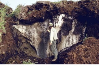
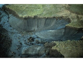
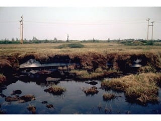
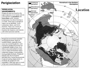
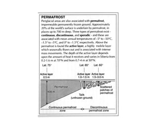
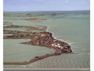
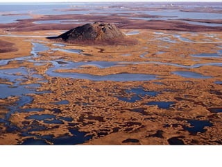
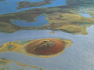
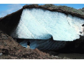
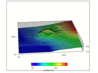
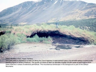
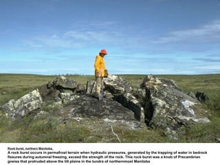
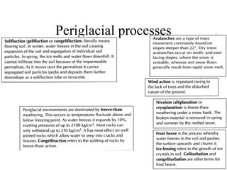
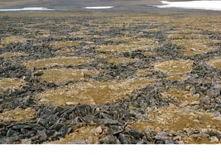
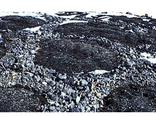
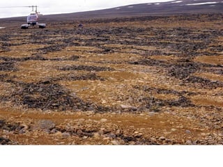
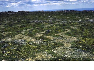
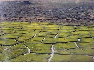
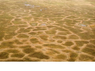
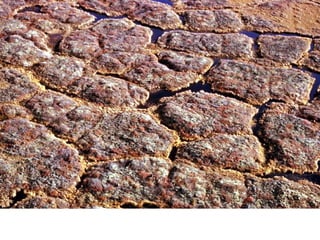
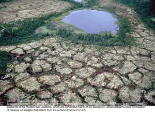
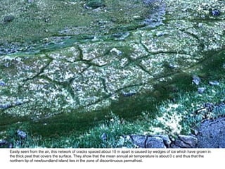
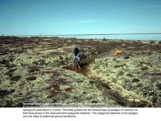
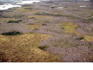
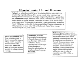
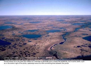
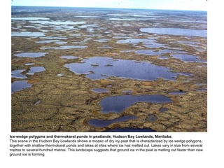
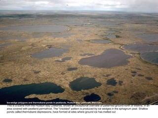
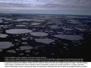
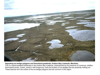
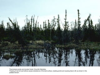
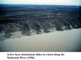
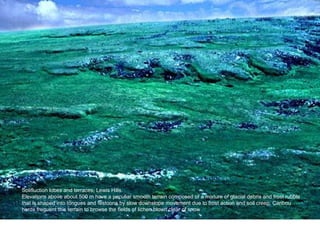
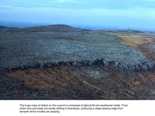
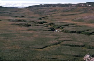
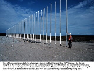
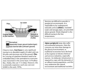
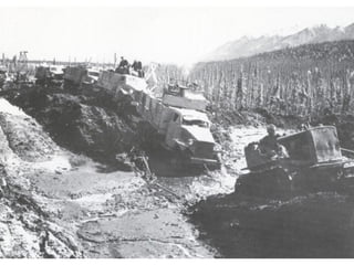
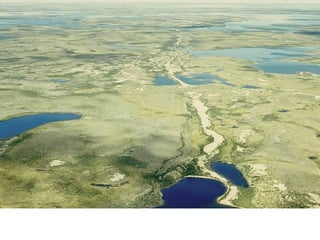
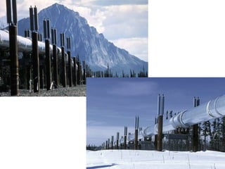
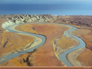
Strange but true…


The Odd Tale
         Of

 Periglacial
Environments
The key to understanding periglacial landforms lies in knowing
all about the one thing these environments have that does not
occur anywhere else on Earth……..


     permafrost
Location
Pingos
And other odd mounds
Palsa, McMillan Pass, Yukon Territory.
This peat palsa is exposed in a road cut along the Canol Highway in east-central Yukon. It is several metres in extent (note
standing figure in centre of feature). The growth of a lens of clear ice elevates roughly circular areas of peat bogs to form
these features in areas of extensive permafrost. The mountainous landscape in the background is part of the Selwyn
Mountains
Rock burst, northern Manitoba.
A rock burst occurs in permafrost terrain when hydraulic pressures, generated by the trapping of water in bedrock
fissures during autumnal freezing, exceed the strength of the rock. This rock burst was a knob of Precambrian
gneiss that protruded above the till plains in the tundra of northernmost Manitoba
Periglacial processes
Patterned
 Ground
  Very very odd indeed…
Ice-wedge polygons in peatland, Hudson Bay Lowlands, Manitoba.
Splendid examples of ice-wedge polygons, a form of patterned ground, are shown above. They occur in the permafrost
peatlands of the Hudson Bay Lowlands, which are composed mainly of dry sphagnum. Brown polygons mark the location
of massive ice wedges that extend from the surface down to 2 or 3 m
Easily seen from the air, this network of cracks spaced about 10 m apart is caused by wedges of ice which have grown in
the thick peat that covers the surface. They show that the mean annual air temperature is about 0 c and thus that the
northern tip of newfoundland island lies in the zone of discontinuous permafrost.
Ice-wedge trough in peat near Steele Lake, Hudson Bay Lowlands, Manitoba.
In this scene, a geologist is coring permafrost on the open tundra heath that is growing on
sphagnum peat about 3 m thick. The deep gutters are the thawed tops of wedges of massive ice
that have grown in the peat and form polygonal networks. The polygonal networks of ice wedges
are one class of patterned ground landforms
Periglacial landforms
thermokarst
  Depressed & shallow
Ice-rich, frozen peatlands and thermokarst ponds, Seal River, Manitoba.
This is an area of permafrost and ice-rich sphagnum peat. Numerous small ponds are thermokarst features that have
formed where ice in the peat has melted out. Drainage is generally poor in these flat peatlands, but in some cases, such
as in the bottom right of the photo, waterways serve as inter-connecting links between the ponds
Ice-wedge polygons and thermokarst ponds in peatlands, Hudson Bay Lowlands, Manitoba.
This scene in the Hudson Bay Lowlands shows a mozaic of dry icy peat that is characterized by ice wedge polygons,
together with shallow thermokarst ponds and lakes at sites where ice has melted out. Lakes vary in size from several
metres to several hundred metres. This landscape suggests that ground ice in the peat is melting out faster than new
ground ice is forming
Ice-wedge polygons and thermokarst ponds in peatlands, Hudson Bay Lowlands, Manitoba.
This is a scene from the Hudson Bay Lowlands, shows an exceptional overview of patterned ground north of treeline, in an
area covered with peatland permafrost. The "crackled" pattern is produced by ice wedges in the sphagnum peat. Shallow
ponds called thermokarst depressions, have formed at sites where ground ice has melted out
Circular thermokarst ponds in peatlands, Hudson Bay Lowlands, Manitoba.
Large, circlular, shallow thermokarst ponds in peatlands of the Hudson Bay Lowlands are formed where the peat has
thawed recently and ground ice has melted out. Their circular shape is an equilibrium configuration resulting from the
progressive thawing and collapse of peat around a body of massive ice that was initially irregular in shape. The thermokarst
ponds range in diameter from tens of metres to about a kilometre, but they are usually only about 1 m deep. Extensive
areas of flat peatland terrain characterize areas of northeastern Manitoba that were covered by postglacial lakes and seas.
Degrading ice-wedge polygons and themokarst peatlands, Hudson Bay Lowlands, Manitoba.
This is a typical peatland landscape in the Hudson Bay Lowlands, characterized by the presence of numerous, shallow
thermokarst ponds. Cracks, shown in left foreground, mark the location of ice wedges that are presently melting out.
These features form the outline of the ice-wedge polygons that are common in this region.
Thermokarst ponds and drunken forest, Churchill, Manitoba.
Thawing of ice-rich permafrost causes subsidence of the land surface, creating ponds and causing trees to tilt, as shown in this
peatland terrain.
Solifluction
  features
    Slip & slide
Active layer detachment slides in a burn along the
Mackenzie River (1996).
Solifluction lobes and terraces, Lewis Hills.
Elevations above about 500 m have a peculiar smooth terrain composed of a mixture of glacial debris and frost rubble
that is shaped into tongues and festoons by slow downslope movement due to frost action and soil creep. Caribou
herds frequent this terrain to browse the fields of lichen blown clear of snow
The huge mass of debris on the summit is composed of glacial till and weathered rubble. Frost
action and soil creep are slowly shifting it downslope, producing a steep leading edge from
beneath which rivulets are seeping
People &
permafrost
  A challenging combination
Row of thermosyphons installed in a frozen core dam at the Ekati Diamond Mine, NWT, to ensure the thermal
integrity of the structure. Thermosyphons are heat exchangers that extract heat from the ground in the winter using
a two-phase convective process and transfer it to the air above. They are in use throughout the North for a variety of
infrastructures. In Yellowknife, for example, they have been used beneath paved roads and parking areas.
This cross-section, from a
site located on a peat
plateau south of Fort
Simpson, shows the
increase in thaw depth, and
the associated ground
surface settlement and pipe
settlement that has occurred
12 years following
construction.
Developing in
 periglacial
  regions
Periglacial processes and features

Periglacial processes and features

  • 1.
    Strange but true… TheOdd Tale Of Periglacial Environments
  • 2.
    The key tounderstanding periglacial landforms lies in knowing all about the one thing these environments have that does not occur anywhere else on Earth…….. permafrost
  • 10.
  • 12.
  • 18.
    Palsa, McMillan Pass,Yukon Territory. This peat palsa is exposed in a road cut along the Canol Highway in east-central Yukon. It is several metres in extent (note standing figure in centre of feature). The growth of a lens of clear ice elevates roughly circular areas of peat bogs to form these features in areas of extensive permafrost. The mountainous landscape in the background is part of the Selwyn Mountains
  • 19.
    Rock burst, northernManitoba. A rock burst occurs in permafrost terrain when hydraulic pressures, generated by the trapping of water in bedrock fissures during autumnal freezing, exceed the strength of the rock. This rock burst was a knob of Precambrian gneiss that protruded above the till plains in the tundra of northernmost Manitoba
  • 20.
  • 21.
    Patterned Ground Very very odd indeed…
  • 29.
    Ice-wedge polygons inpeatland, Hudson Bay Lowlands, Manitoba. Splendid examples of ice-wedge polygons, a form of patterned ground, are shown above. They occur in the permafrost peatlands of the Hudson Bay Lowlands, which are composed mainly of dry sphagnum. Brown polygons mark the location of massive ice wedges that extend from the surface down to 2 or 3 m
  • 30.
    Easily seen fromthe air, this network of cracks spaced about 10 m apart is caused by wedges of ice which have grown in the thick peat that covers the surface. They show that the mean annual air temperature is about 0 c and thus that the northern tip of newfoundland island lies in the zone of discontinuous permafrost.
  • 31.
    Ice-wedge trough inpeat near Steele Lake, Hudson Bay Lowlands, Manitoba. In this scene, a geologist is coring permafrost on the open tundra heath that is growing on sphagnum peat about 3 m thick. The deep gutters are the thawed tops of wedges of massive ice that have grown in the peat and form polygonal networks. The polygonal networks of ice wedges are one class of patterned ground landforms
  • 33.
  • 34.
  • 35.
    Ice-rich, frozen peatlandsand thermokarst ponds, Seal River, Manitoba. This is an area of permafrost and ice-rich sphagnum peat. Numerous small ponds are thermokarst features that have formed where ice in the peat has melted out. Drainage is generally poor in these flat peatlands, but in some cases, such as in the bottom right of the photo, waterways serve as inter-connecting links between the ponds
  • 36.
    Ice-wedge polygons andthermokarst ponds in peatlands, Hudson Bay Lowlands, Manitoba. This scene in the Hudson Bay Lowlands shows a mozaic of dry icy peat that is characterized by ice wedge polygons, together with shallow thermokarst ponds and lakes at sites where ice has melted out. Lakes vary in size from several metres to several hundred metres. This landscape suggests that ground ice in the peat is melting out faster than new ground ice is forming
  • 37.
    Ice-wedge polygons andthermokarst ponds in peatlands, Hudson Bay Lowlands, Manitoba. This is a scene from the Hudson Bay Lowlands, shows an exceptional overview of patterned ground north of treeline, in an area covered with peatland permafrost. The "crackled" pattern is produced by ice wedges in the sphagnum peat. Shallow ponds called thermokarst depressions, have formed at sites where ground ice has melted out
  • 38.
    Circular thermokarst pondsin peatlands, Hudson Bay Lowlands, Manitoba. Large, circlular, shallow thermokarst ponds in peatlands of the Hudson Bay Lowlands are formed where the peat has thawed recently and ground ice has melted out. Their circular shape is an equilibrium configuration resulting from the progressive thawing and collapse of peat around a body of massive ice that was initially irregular in shape. The thermokarst ponds range in diameter from tens of metres to about a kilometre, but they are usually only about 1 m deep. Extensive areas of flat peatland terrain characterize areas of northeastern Manitoba that were covered by postglacial lakes and seas.
  • 39.
    Degrading ice-wedge polygonsand themokarst peatlands, Hudson Bay Lowlands, Manitoba. This is a typical peatland landscape in the Hudson Bay Lowlands, characterized by the presence of numerous, shallow thermokarst ponds. Cracks, shown in left foreground, mark the location of ice wedges that are presently melting out. These features form the outline of the ice-wedge polygons that are common in this region.
  • 41.
    Thermokarst ponds anddrunken forest, Churchill, Manitoba. Thawing of ice-rich permafrost causes subsidence of the land surface, creating ponds and causing trees to tilt, as shown in this peatland terrain.
  • 42.
  • 43.
    Active layer detachmentslides in a burn along the Mackenzie River (1996).
  • 44.
    Solifluction lobes andterraces, Lewis Hills. Elevations above about 500 m have a peculiar smooth terrain composed of a mixture of glacial debris and frost rubble that is shaped into tongues and festoons by slow downslope movement due to frost action and soil creep. Caribou herds frequent this terrain to browse the fields of lichen blown clear of snow
  • 45.
    The huge massof debris on the summit is composed of glacial till and weathered rubble. Frost action and soil creep are slowly shifting it downslope, producing a steep leading edge from beneath which rivulets are seeping
  • 47.
    People & permafrost A challenging combination
  • 48.
    Row of thermosyphonsinstalled in a frozen core dam at the Ekati Diamond Mine, NWT, to ensure the thermal integrity of the structure. Thermosyphons are heat exchangers that extract heat from the ground in the winter using a two-phase convective process and transfer it to the air above. They are in use throughout the North for a variety of infrastructures. In Yellowknife, for example, they have been used beneath paved roads and parking areas.
  • 49.
    This cross-section, froma site located on a peat plateau south of Fort Simpson, shows the increase in thaw depth, and the associated ground surface settlement and pipe settlement that has occurred 12 years following construction.
  • 54.