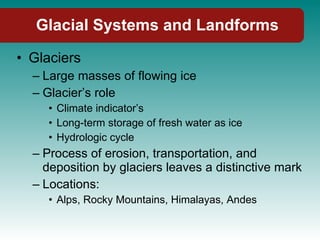
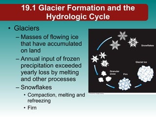
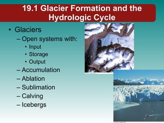
Chapter 19: Glacial Systems and Landforms Physical Geography Ninth Edition Robert E. Gabler James. F. Petersen L. Michael Trapasso Dorothy Sack
Glacial Systems and Landforms
Glacial Systems and Landforms Glaciers Large masses of flowing ice Glacier’s role Climate indicator’s Long-term storage of fresh water as ice Hydrologic cycle Process of erosion, transportation, and deposition by glaciers leaves a distinctive mark Locations: Alps, Rocky Mountains, Himalayas, Andes
19.1 Glacier Formation and the Hydrologic Cycle Glaciers Masses of flowing ice that have accumulated on land Annual input of frozen precipitation exceeded yearly loss by melting and other processes Snowflakes Compaction, melting and refreezing Firn
19.1 Glacier Formation and the Hydrologic Cycle Glaciers Open systems with: Input Storage Output Accumulation Ablation Sublimation Calving Icebergs
19.1 Glacier Formation and the Hydrologic Cycle Glaciers Controlled by 2 basic climatic conditions: Precipitation Freezing temperatures 2.25% of Earth’s total water 70% of Earth’s fresh water Moves slowly with tremendous energy
19.2 Types of Glaciers Two Major categories Alpine Continental Alpine (High elevation) Fed by ice and snow in mountain areas Usually occupy preexisting valleys Valley glaciers
19.2 Types of Glaciers Alpine (High elevation) Piedmont glaciers Ice flows beyond the valley, spreading out over flatter land Cirque glaciers Smallest type Locations: Rockies, Sierra Nevada, Cascades, Olympic, Coast Range Andes, Himalaya, Mount Kenya and Kilimanjaro
19.2 Types of Glaciers Continental glaciers Much larger and thicker High latitude 2 polar ice sheets Greenland Antarctica Ice caps Q: How is radial ice flow both similar to and different from the radial drainage pattern observed for some stream systems?
19.3 How do Glaciers flow? Movement Processes Internal plastic deformation Weight of overlying ice, firn, and snow causes ice crystals at depth to arrange themselves in parallel layers that glide over each other
19.3 How do Glaciers flow? Movement Processes Processes at base Basal sliding Processes at top Brittle ice Fractures and cracks Crevasses Icefalls
19.4 Glaciers as Geomorphic Agents Glaciers remove and entrain rock particles by 2 erosion processes Plucking Moving ice freezes onto loosened rocks, incorporating them into the flow Abrasion Q: How does sediment load of a glacier differ from sediment load of a stream?
19.5 Alpine Glaciers Zone of accumulation (input) Zone of ablation (ablation exceeds accumulation)
19.5 Alpine Glaciers Equilibrium line (boundary) Q: What additional information would be needed to assess if the boundary between the white and blue zones on this photo is the glacier’s annual equilibrium line?
19.5 Alpine Glaciers Factors influencing Equilibrium line Latitude Elevation Temperature Amount of insolation Mountain slope Wind Q: Do any slope characteristics vary by aspect in the region where you live?
19.5 Alpine Glaciers Glacier’s head Cirque headwall Bergschrund Terminus
19.5 Alpine Glaciers Equilibrium and the Glacial Budget Changes throughout year Growing or shrinking: Observe terminus Advance (further down valley) Retreat Most receding since 1890
19.5 Alpine Glaciers Erosional Landforms of Alpine Glaciation Striations Linear scratches, grooves, and gouges Direction of ice flow Q: Can the direction of ice flow be determined with certainty from the evidence in this photograph?
19.5 Alpine Glaciers Erosional Landforms of Alpine Glaciation Roches moutonnées Asymmetric bedrock hills or knobs Smoothly rounded on the up-side by abrasion Plucking on down-ice side
19.5 Alpine Glaciers Erosional Landforms of Alpine Glaciation Cirque Bowls Cirque lakes Arête Jagged sawtooth-shaped spine of rock
19.5 Alpine Glaciers Erosional Landforms of Alpine Glaciation Horn 3 or more cirques meet Pyramid shape Matterhorn Col Pass formed by headward erosion of 2 cirques Glacial trough
19.5 Alpine Glaciers Erosional Landforms of Alpine Glaciation Paternoster lakes Glacier creates rock steps and excavated basins This forms Lake chains Fjord Abandoned glacial trough that use to extend down to ocean
19.5 Alpine Glaciers Erosional Landforms of Alpine Glaciation Hanging Valleys Waterfall Yosemite Valley, CA
19.5 Alpine Glaciers Depositional Landforms of Alpine Glaciation Glaciofluvial Drift Moraines Lateral moraines
19.5 Alpine Glaciers Depositional Landforms of Alpine Glaciation Medial moraine End moraine Terminal moraine Recessional moraine Ground moraine Glacial outwash
19.6 Continental Glaciers Ice sheets & Ice caps Convex lens cross section Thick in center and thinning toward edges Q: How is this manner of ice flow difference from and similar to that of a valley glacier?
19.6 Continental Glaciers Existing Continental Glaciers Cover about 10% of Earth Locations: Iceland, arctic islands, Greenland ice sheet, and Antarctic Ice Sheet Outlet glaciers
19.6 Continental Glaciers Existing Continental Glaciers Antarctic Ice Sheet
19.6 Continental Glaciers Existing Continental Glaciers Antarctic Ice Sheet Ice sheet
19.6 Continental Glaciers Pleistocene Glaciation Began 2.4 mya and ended 10,000 years ago Maximum extent: ice covered 1/3 of Earth Interglacial Sea level changes
19.6 Continental Glaciers Continental Glaciers and Erosional Landforms Ice scoured plains
19.6 Continental Glaciers Continental Glaciers and Depositional Landforms End Moraines Till Plains Outwash Plains Drumlins Eskers Kames Erratics
19.6 Continental Glaciers End Moraines
19.6 Continental Glaciers Till Plains Outwash Plains Kettles Kettle lakes Drumlin
19.6 Continental Glaciers Esker Kames Kame terraces Erratics
19.7 Glacial Lakes Pleistocene ice sheets created numerous lake basins Finger Lakes, NY Great lakes, US Lake Chelan, WA Ice-marginal lakes
19.7 Glacial Lakes Lake Missoula Scablands Dry waterfalls
19.7 Glacial Lakes Great Lakes World’s largest lake system
19.8 Periglacial Landscapes Periglacial environments High latitudes of N. hemisphere Lacking year round ice or snow undergoing intense frost action Frost action Freezing/thawing of soil Frost heave and thaw settlement Patterned ground
19.8 Periglacial Landscapes Permafrost Solifluction Ice wedge polygons Construction Techniques Build above ground Climate Change and permafrost Thermokarst development Release of Carbon Dioxide and Methane
Physical Geography End of Chapter 19: Glacial Systems and Landforms

Chapter19 glacial systems

  • 1.
    Chapter 19: GlacialSystems and Landforms Physical Geography Ninth Edition Robert E. Gabler James. F. Petersen L. Michael Trapasso Dorothy Sack
  • 2.
  • 3.
    Glacial Systems andLandforms Glaciers Large masses of flowing ice Glacier’s role Climate indicator’s Long-term storage of fresh water as ice Hydrologic cycle Process of erosion, transportation, and deposition by glaciers leaves a distinctive mark Locations: Alps, Rocky Mountains, Himalayas, Andes
  • 4.
    19.1 Glacier Formationand the Hydrologic Cycle Glaciers Masses of flowing ice that have accumulated on land Annual input of frozen precipitation exceeded yearly loss by melting and other processes Snowflakes Compaction, melting and refreezing Firn
  • 5.
    19.1 Glacier Formationand the Hydrologic Cycle Glaciers Open systems with: Input Storage Output Accumulation Ablation Sublimation Calving Icebergs
  • 6.
    19.1 Glacier Formationand the Hydrologic Cycle Glaciers Controlled by 2 basic climatic conditions: Precipitation Freezing temperatures 2.25% of Earth’s total water 70% of Earth’s fresh water Moves slowly with tremendous energy
  • 7.
    19.2 Types ofGlaciers Two Major categories Alpine Continental Alpine (High elevation) Fed by ice and snow in mountain areas Usually occupy preexisting valleys Valley glaciers
  • 8.
    19.2 Types ofGlaciers Alpine (High elevation) Piedmont glaciers Ice flows beyond the valley, spreading out over flatter land Cirque glaciers Smallest type Locations: Rockies, Sierra Nevada, Cascades, Olympic, Coast Range Andes, Himalaya, Mount Kenya and Kilimanjaro
  • 9.
    19.2 Types ofGlaciers Continental glaciers Much larger and thicker High latitude 2 polar ice sheets Greenland Antarctica Ice caps Q: How is radial ice flow both similar to and different from the radial drainage pattern observed for some stream systems?
  • 10.
    19.3 How doGlaciers flow? Movement Processes Internal plastic deformation Weight of overlying ice, firn, and snow causes ice crystals at depth to arrange themselves in parallel layers that glide over each other
  • 11.
    19.3 How doGlaciers flow? Movement Processes Processes at base Basal sliding Processes at top Brittle ice Fractures and cracks Crevasses Icefalls
  • 12.
    19.4 Glaciers asGeomorphic Agents Glaciers remove and entrain rock particles by 2 erosion processes Plucking Moving ice freezes onto loosened rocks, incorporating them into the flow Abrasion Q: How does sediment load of a glacier differ from sediment load of a stream?
  • 13.
    19.5 Alpine GlaciersZone of accumulation (input) Zone of ablation (ablation exceeds accumulation)
  • 14.
    19.5 Alpine GlaciersEquilibrium line (boundary) Q: What additional information would be needed to assess if the boundary between the white and blue zones on this photo is the glacier’s annual equilibrium line?
  • 15.
    19.5 Alpine GlaciersFactors influencing Equilibrium line Latitude Elevation Temperature Amount of insolation Mountain slope Wind Q: Do any slope characteristics vary by aspect in the region where you live?
  • 16.
    19.5 Alpine GlaciersGlacier’s head Cirque headwall Bergschrund Terminus
  • 17.
    19.5 Alpine GlaciersEquilibrium and the Glacial Budget Changes throughout year Growing or shrinking: Observe terminus Advance (further down valley) Retreat Most receding since 1890
  • 18.
    19.5 Alpine GlaciersErosional Landforms of Alpine Glaciation Striations Linear scratches, grooves, and gouges Direction of ice flow Q: Can the direction of ice flow be determined with certainty from the evidence in this photograph?
  • 19.
    19.5 Alpine GlaciersErosional Landforms of Alpine Glaciation Roches moutonnées Asymmetric bedrock hills or knobs Smoothly rounded on the up-side by abrasion Plucking on down-ice side
  • 20.
    19.5 Alpine GlaciersErosional Landforms of Alpine Glaciation Cirque Bowls Cirque lakes Arête Jagged sawtooth-shaped spine of rock
  • 21.
    19.5 Alpine GlaciersErosional Landforms of Alpine Glaciation Horn 3 or more cirques meet Pyramid shape Matterhorn Col Pass formed by headward erosion of 2 cirques Glacial trough
  • 22.
    19.5 Alpine GlaciersErosional Landforms of Alpine Glaciation Paternoster lakes Glacier creates rock steps and excavated basins This forms Lake chains Fjord Abandoned glacial trough that use to extend down to ocean
  • 23.
    19.5 Alpine GlaciersErosional Landforms of Alpine Glaciation Hanging Valleys Waterfall Yosemite Valley, CA
  • 24.
    19.5 Alpine GlaciersDepositional Landforms of Alpine Glaciation Glaciofluvial Drift Moraines Lateral moraines
  • 25.
    19.5 Alpine GlaciersDepositional Landforms of Alpine Glaciation Medial moraine End moraine Terminal moraine Recessional moraine Ground moraine Glacial outwash
  • 26.
    19.6 Continental GlaciersIce sheets & Ice caps Convex lens cross section Thick in center and thinning toward edges Q: How is this manner of ice flow difference from and similar to that of a valley glacier?
  • 27.
    19.6 Continental GlaciersExisting Continental Glaciers Cover about 10% of Earth Locations: Iceland, arctic islands, Greenland ice sheet, and Antarctic Ice Sheet Outlet glaciers
  • 28.
    19.6 Continental GlaciersExisting Continental Glaciers Antarctic Ice Sheet
  • 29.
    19.6 Continental GlaciersExisting Continental Glaciers Antarctic Ice Sheet Ice sheet
  • 30.
    19.6 Continental GlaciersPleistocene Glaciation Began 2.4 mya and ended 10,000 years ago Maximum extent: ice covered 1/3 of Earth Interglacial Sea level changes
  • 31.
    19.6 Continental GlaciersContinental Glaciers and Erosional Landforms Ice scoured plains
  • 32.
    19.6 Continental GlaciersContinental Glaciers and Depositional Landforms End Moraines Till Plains Outwash Plains Drumlins Eskers Kames Erratics
  • 33.
  • 34.
    19.6 Continental GlaciersTill Plains Outwash Plains Kettles Kettle lakes Drumlin
  • 35.
    19.6 Continental GlaciersEsker Kames Kame terraces Erratics
  • 36.
    19.7 Glacial LakesPleistocene ice sheets created numerous lake basins Finger Lakes, NY Great lakes, US Lake Chelan, WA Ice-marginal lakes
  • 37.
    19.7 Glacial LakesLake Missoula Scablands Dry waterfalls
  • 38.
    19.7 Glacial LakesGreat Lakes World’s largest lake system
  • 39.
    19.8 Periglacial LandscapesPeriglacial environments High latitudes of N. hemisphere Lacking year round ice or snow undergoing intense frost action Frost action Freezing/thawing of soil Frost heave and thaw settlement Patterned ground
  • 40.
    19.8 Periglacial LandscapesPermafrost Solifluction Ice wedge polygons Construction Techniques Build above ground Climate Change and permafrost Thermokarst development Release of Carbon Dioxide and Methane
  • 41.
    Physical Geography Endof Chapter 19: Glacial Systems and Landforms

Editor's Notes

  • #3 Insert cover image for Chapter 19 (p. 522)
  • #5 Insert Figure 19.1
  • #6 Insert Figure 19.2
  • #7 Insert Figure 19.3
  • #8 Insert Figure 19.4
  • #9 Insert Figure 19.5
  • #10 Insert Figure 19.6
  • #11 Insert Figure 19.7
  • #12 Insert Figure 19.8 and 19.9
  • #13 Insert Figure 19.10
  • #14 Insert Figure 19.11
  • #15 Insert Figure 19.12
  • #16 Insert Figure 19.13
  • #17 Insert Figure 19.11
  • #18 Insert Figure 19.14
  • #19 Insert Figure 19.15
  • #20 Insert Figure 19.16
  • #21 Insert Figure 19.17a and 19.17b
  • #22 Insert Figure 19.17c and 19.17d
  • #23 Insert Figure 19.18
  • #24 Insert Figure 19.19 and 19.20
  • #25 Insert Figure 19.22 and 19.23a
  • #26 Insert Figure 19.23b and 19.23c
  • #27 Insert Figure 19.25
  • #28 Insert Figure 19.26
  • #29 Insert Figure 19.27
  • #30 Insert Figure 19.28
  • #31 Insert Figure 19.30
  • #32 Insert Figure 19.31
  • #33 Insert Figure 19.32
  • #34 Insert Figure 19.33 and 19.34
  • #35 Insert Figure 19.35 and 19.36
  • #36 Insert Figure 19.36b and 19.37
  • #37 Insert Figure 19.38 and 19.39
  • #38 Insert Figure 19.40
  • #39 Insert Figure 19.41
  • #40 Insert Figure 19.42
  • #41 Insert Figure 19.43