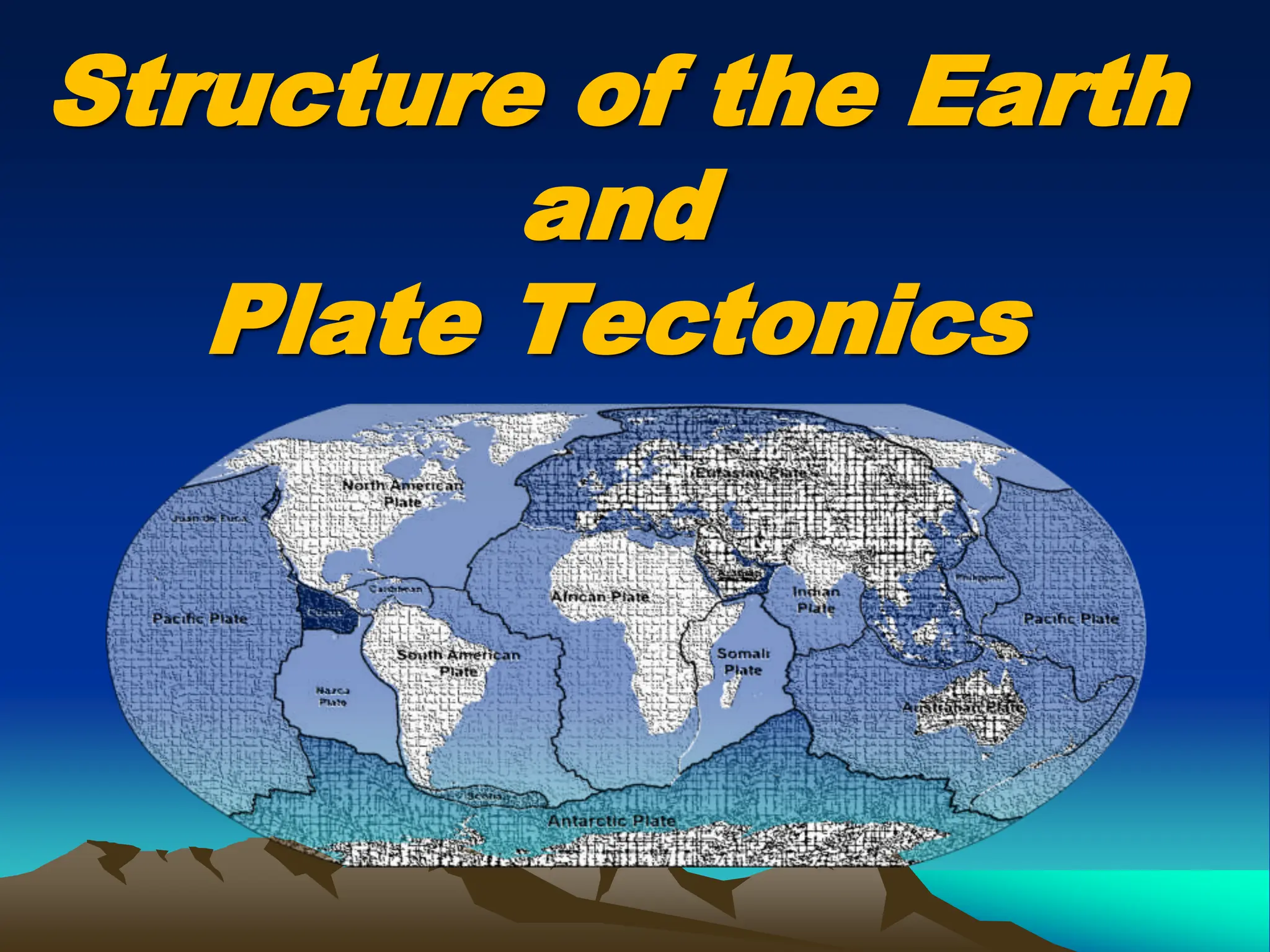
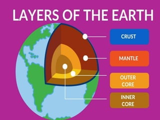
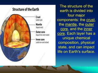
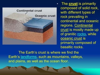
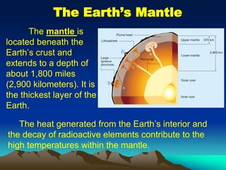
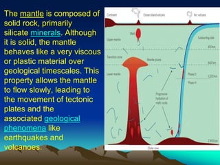
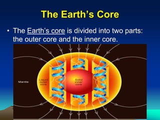
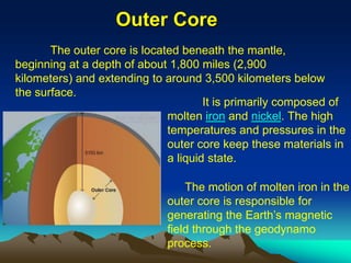
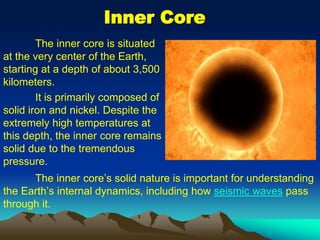
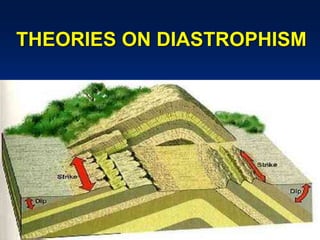
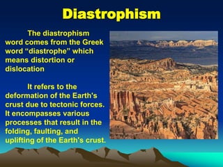
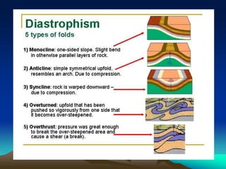
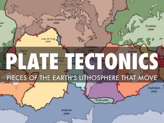
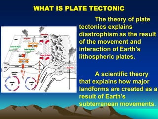
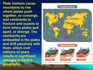
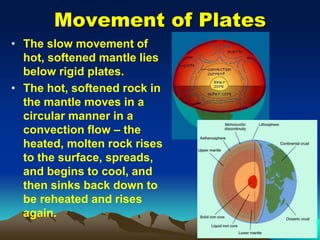
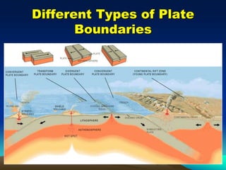
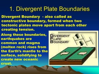
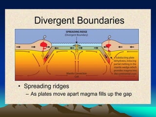
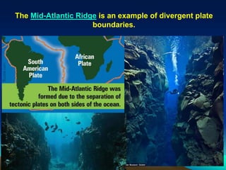
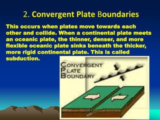
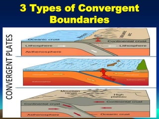
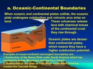
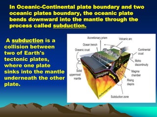
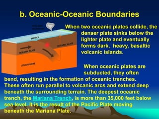
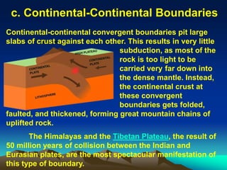
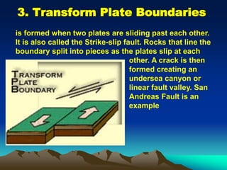
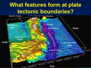
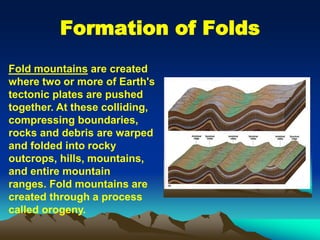
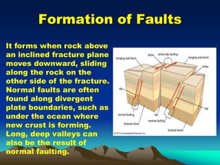
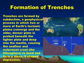
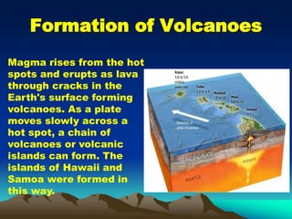
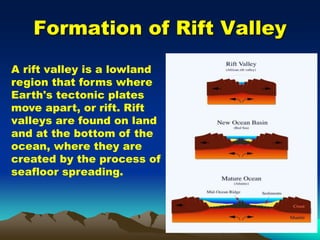
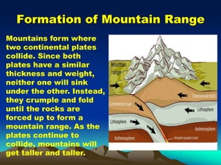
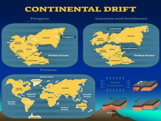
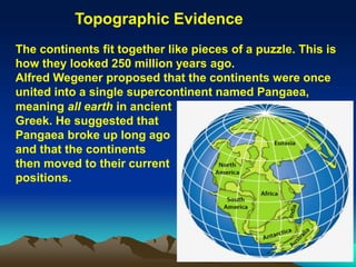
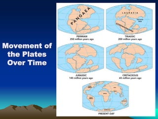
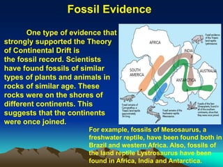
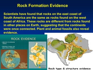
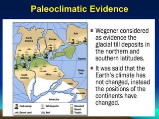
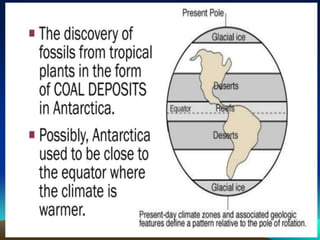
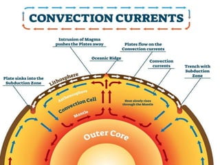
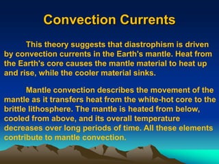
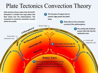
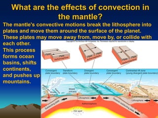
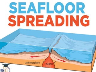
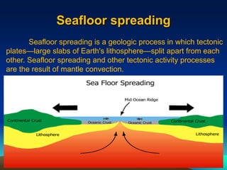
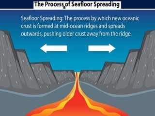
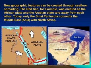
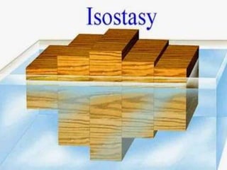
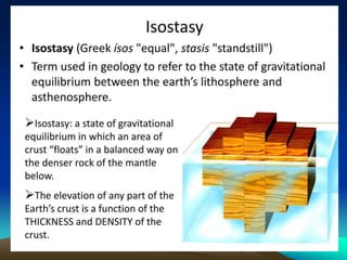
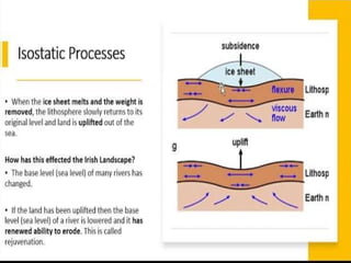
Structure of the Earth
and
Plate Tectonics
Objectives
At the end of the lesson, the students should be able
to:
1. Explore the Earth's internal structure, including its
layers.
2. Understand the principles of plate tectonics and
how they shape the Earth's surface.
3. Examine the theory of diastrophism and its effects
on the Earth's surface
4. Investigate the theory of continental drift and the
evidence supporting the movement of tectonic
plates.
5. Analyze the process of seafloor spreading and its
role in forming and shifting tectonic plates.
The structure of the
earth is divided into
four major
components: the crust,
the mantle, the outer
core, and the inner
core. Each layer has a
unique chemical
composition, physical
state, and can impact
life on Earth's surface.
The Earth’s Crust
• -is the outermost
layer and the one we
interact with directly.
It varies in thickness,
with oceanic crust
being thinner (about
4-7 miles or 6-11
kilometers) and
continental crust
being thicker
(averaging about 19
miles or 30
kilometers).
The Earth’s crust is where we find the
Earth’s landforms, such as mountains, valleys,
and plains, as well as the ocean floor.
• The crust is primarily
composed of solid rock,
with different types of
rock prevailing in
continental and oceanic
regions. Continental
crust is mostly made up
of granitic rocks, while
oceanic crust is
primarily composed of
basaltic rocks.
The Earth’s Mantle
The mantle is
located beneath the
Earth’s crust and
extends to a depth of
about 1,800 miles
(2,900 kilometers). It is
the thickest layer of the
Earth.
The heat generated from the Earth’s interior and
the decay of radioactive elements contribute to the
high temperatures within the mantle.
The mantle is composed of
solid rock, primarily
silicate minerals. Although
it is solid, the mantle
behaves like a very viscous
or plastic material over
geological timescales. This
property allows the mantle
to flow slowly, leading to
the movement of tectonic
plates and the
associated geological
phenomena like
earthquakes and
volcanoes.
The Earth’s Core
• The Earth’s core is divided into two parts:
the outer core and the inner core.
Outer Core
The outer core is located beneath the mantle,
beginning at a depth of about 1,800 miles (2,900
kilometers) and extending to around 3,500 kilometers below
the surface.
It is primarily composed of
molten iron and nickel. The high
temperatures and pressures in the
outer core keep these materials in
a liquid state.
The motion of molten iron in the
outer core is responsible for
generating the Earth’s magnetic
field through the geodynamo
process.
Inner Core
The inner core’s solid nature is important for understanding
the Earth’s internal dynamics, including how seismic waves pass
through it.
The inner core is situated
at the very center of the Earth,
starting at a depth of about 3,500
kilometers.
It is primarily composed of
solid iron and nickel. Despite the
extremely high temperatures at
this depth, the inner core remains
solid due to the tremendous
pressure.
THEORIES ON DIASTROPHISM
Diastrophism
The diastrophism
word comes from the Greek
word “diastrophe” which
means distortion or
dislocation
It refers to the
deformation of the Earth's
crust due to tectonic forces.
It encompasses various
processes that result in the
folding, faulting, and
uplifting of the Earth's crust.
WHAT IS PLATE TECTONIC
The theory of plate
tectonics explains
diastrophism as the result
of the movement and
interaction of Earth's
lithospheric plates.
A scientific theory
that explains how major
landforms are created as a
result of Earth's
subterranean movements.
• Plate motions cause
mountains to rise
where plates push
together, or converge,
and continents to
fracture and oceans to
form where plates pull
apart, or diverge. The
continents are
embedded in the plates
and drift passively with
them, which over
millions of years
results in significant
changes in Earth's
geography.
Movement of Plates
• The slow movement of
hot, softened mantle lies
below rigid plates.
• The hot, softened rock in
the mantle moves in a
circular manner in a
convection flow – the
heated, molten rock rises
to the surface, spreads,
and begins to cool, and
then sinks back down to
be reheated and rises
again.
Different Types of Plate
Boundaries
1. Divergent Plate Boundaries
Divergent Boundary - also called as
constructive boundary, formed when two
tectonic plates move apart from each other
creating tension.
Along these boundaries,
earthquakes are
common and magma
(molten rock) rises from
the Earth’s mantle to the
surface, solidifying to
create new oceanic
crust.
The Mid-Atlantic Ridge is an example of divergent plate
boundaries.
2. Convergent Plate Boundaries
This occurs when plates move towards each
other and collide. When a continental plate meets
an oceanic plate, the thinner, denser, and more
flexible oceanic plate sinks beneath the thicker,
more rigid continental plate. This is called
subduction.
3 Types of Convergent
Boundaries
a. Oceanic-Continental Boundaries
When oceanic and continental plates collide, the oceanic
plate undergoes subduction and volcanic arcs arise on
land. These volcanoes release
lava with chemical traces
of the continental crust
they rise through.
Oceanic plates are denser
than continental plates,
which means they have a
higher subduction potential.
Examples of ocean-continent convergent boundaries are:
1.Subduction of the Nazca Plate under South America which has
created the Andes Mountains and the Peru Trench
2. Subduction of the Juan de Fuca Plate under North America
created the Cascade Range
In Oceanic-Continental plate boundary and two
oceanic plates boundary, the oceanic plate
bends downward into the mantle through the
process called subduction.
A subduction is a
collision between
two of Earth's
tectonic plates,
where one plate
sinks into the mantle
underneath the other
plate.
b. Oceanic-Oceanic Boundaries
When two oceanic plates collide, the
denser plate sinks below the
lighter plate and eventually
forms dark, heavy, basaltic
volcanic islands.
When oceanic plates are
subducted, they often
bend, resulting in the formation of oceanic trenches.
These often run parallel to volcanic arcs and extend deep
beneath the surrounding terrain. The deepest oceanic
trench, the Mariana Trench, is more than 35,000 feet below
sea level. It is the result of the Pacific Plate moving
beneath the Mariana Plate.
c. Continental-Continental Boundaries
Continental-continental convergent boundaries pit large
slabs of crust against each other. This results in very little
subduction, as most of the
rock is too light to be
carried very far down into
the dense mantle. Instead,
the continental crust at
these convergent
boundaries gets folded,
faulted, and thickened, forming great mountain chains of
uplifted rock.
The Himalayas and the Tibetan Plateau, the result of
50 million years of collision between the Indian and
Eurasian plates, are the most spectacular manifestation of
this type of boundary.
3. Transform Plate Boundaries
is formed when two plates are sliding past each other.
It is also called the Strike-slip fault. Rocks that line the
boundary split into pieces as the plates slip at each
other. A crack is then
formed creating an
undersea canyon or
linear fault valley. San
Andreas Fault is an
example
What features form at plate
tectonic boundaries?
Fold mountains are created
where two or more of Earth's
tectonic plates are pushed
together. At these colliding,
compressing boundaries,
rocks and debris are warped
and folded into rocky
outcrops, hills, mountains,
and entire mountain
ranges. Fold mountains are
created through a process
called orogeny.
Formation of Folds
Formation of Faults
It forms when rock above
an inclined fracture plane
moves downward, sliding
along the rock on the
other side of the fracture.
Normal faults are often
found along divergent
plate boundaries, such as
under the ocean where
new crust is forming.
Long, deep valleys can
also be the result of
normal faulting.
Formation of Trenches
Trenches are formed by
subduction, a geophysical
process in which two or
more of Earth's tectonic
plates converge and the
older, denser plate is
pushed beneath the
lighter plate and deep
into the mantle, causing
the seafloor and
outermost crust (the
lithosphere) to bend and
form a steep, V-shaped
depression.
Formation of Volcanoes
Magma rises from the hot
spots and erupts as lava
through cracks in the
Earth's surface forming
volcanoes. As a plate
moves slowly across a
hot spot, a chain of
volcanoes or volcanic
islands can form. The
islands of Hawaii and
Samoa were formed in
this way.
Formation of Rift Valley
A rift valley is a lowland
region that forms where
Earth's tectonic plates
move apart, or rift. Rift
valleys are found on land
and at the bottom of the
ocean, where they are
created by the process of
seafloor spreading.
Formation of Mountain Range
Mountains form where
two continental plates
collide. Since both
plates have a similar
thickness and weight,
neither one will sink
under the other. Instead,
they crumple and fold
until the rocks are
forced up to form a
mountain range. As the
plates continue to
collide, mountains will
get taller and taller.
Continental Drift
The theory of continental drift, proposed by Alfred
Wegener in the early 20th century, suggests that the
Earth's continents were once joined together in a single
supercontinent called Pangaea. Over time, the continents
drifted apart due to the movement of tectonic plates.
Wagner believed in three-layer system; outer layer
of sial, intermediate layer of sima and lower layer of nife.
(sial is restricted to continent only and sialic masses float
over)
According to Wegener, all continents formed a single
continental mass (PANGEA) & mega ocean (PANTHALASSA)
surrounded the same.
Around 200 million years ago, Pangaea first broke into
two large continental masses as Laurasia (Present day- N.
America, Europe and Asia) and Gondwana (Present day S.
America, Africa, India, Australia and Antarctica).
Subsequently, Laurasia and Gondwanaland continued to
break into various smaller continents that exist today.
The continents fit together like pieces of a puzzle. This is
how they looked 250 million years ago.
Alfred Wegener proposed that the continents were once
united into a single supercontinent named Pangaea,
Topographic Evidence
meaning all earth in ancient
Greek. He suggested that
Pangaea broke up long ago
and that the continents
then moved to their current
positions.
Movement of
the Plates
Over Time
One type of evidence that
strongly supported the Theory
of Continental Drift is
the fossil record. Scientists
have found fossils of similar
types of plants and animals in
rocks of similar age. These
rocks were on the shores of
different continents. This
suggests that the continents
were once joined.
For example, fossils of Mesosaurus, a
freshwater reptile, have been found both in
Brazil and western Africa. Also, fossils of
the land reptile Lystrosaurus have been
found in Africa, India and Antarctica.
Fossil Evidence
Scientists have found that rocks on the east coast of
South America are the same as rocks found on the west
coast of Africa. These rocks are different from rocks found
in other places on Earth, suggesting that the continents
were once connected. Plant and animal fossils also reveal
evidence.
Rock Formation Evidence
Paleoclimatic Evidence
Convection Currents
This theory suggests that diastrophism is driven
by convection currents in the Earth's mantle. Heat from
the Earth's core causes the mantle material to heat up
and rise, while the cooler material sinks.
Mantle convection describes the movement of the
mantle as it transfers heat from the white-hot core to the
brittle lithosphere. The mantle is heated from below,
cooled from above, and its overall temperature
decreases over long periods of time. All these elements
contribute to mantle convection.
What are the effects of convection in
the mantle?
The mantle's convective motions break the lithosphere into
plates and move them around the surface of the planet.
These plates may move away from, move by, or collide with
each other.
This process
forms ocean
basins, shifts
continents,
and pushes up
mountains.
Seafloor spreading
Seafloor spreading is a geologic process in which tectonic
plates—large slabs of Earth's lithosphere—split apart from each
other. Seafloor spreading and other tectonic activity processes
are the result of mantle convection.
New geographic features can be created through seafloor
spreading. The Red Sea, for example, was created as the
African plate and the Arabian plate tore away from each
other. Today, only the Sinai Peninsula connects the
Middle East (Asia) with North Africa.
The Theory of Isostasy
The Theory of Isostasy by Airy is a fundamental
concept in the field of geophysics that seeks to explain
the equilibrium and balance of Earth's crust. This theory,
proposed by the renowned British mathematician and
scientist Sir George Biddell Airy in the 19th century,
revolutionized our understanding of how the Earth's
lithosphere behaves and its implications for the
formation of mountains, continents, and ocean basins. In
this article, we will delve into the theory of isostasy, its
key principles, and its significance in the field of
geography
References
• Understanding Plate Motions. USGS.
http://pubs.usgs.gov/publications/text/unde
rstanding.html
• Plate Movement. OptIPuter Outreach.
http://education.sdsc.edu/optiputer/teacher
s/platemovement.html
• Plate Tectonics. The Way the Earth
Works. LHS GEMS, 2002.
https://www.google.com/search?q=isostasy+process&tbm=isch&ved=2ahUKEwiQ0K
3g8OCEAxVCj2MGHeHIBKIQ2-
cCegQIABAA&oq=isostasy+process&gs_lp=EgNpbWciEGlzb3N0YXN5IHByb2Nlc3N
I1GVQuQZYt2NwAHgAkAEDmAH-
AaAB4iqqAQYwLjQxLjK4AQPIAQD4AQGKAgtnd3Mtd2l6LWltZ6gCAMICChAAGIAE
GIoFGEPCAggQABiABBixA8ICBRAAGIAEwgILEAAYgAQYsQMYgwHCAgYQABgIG
B7CAgcQABiABBgYiAYB&sclient=img&ei=YAjpZZCgAsKejuMP4ZGTkAo&bih=633&
biw=1366&hl=en#imgrc=cGczrhoN04qLTM
https://education.nationalgeographic.org/resource/seafloor-spreading/
https://www.google.com/search?q=The+Red+Sea%2C+for+example%2C+was+creat
ed+as+the+African+plate+and+the+Arabian+plate+tore+away+from+each+othe&oq=
The+Red+Sea%2C+for+example%2C+was+created+as+the+African+plate+and+the
+Arabian+plate+tore+away+from+each+othe&gs_lcrp=EgZjaHJvbWUyBggAEEUYO
dIBCTI2NDZqMGoxNagCALACAA&sourceid=chrome&ie=UTF-8
https://manoa.hawaii.edu/exploringourfluidearth/physical/ocean-floor/continental-
movement-plate-tectonics

plate-tectonics-ppppppppppower-point.ppt

  • 1.
    Structure of theEarth and Plate Tectonics
  • 2.
    Objectives At the endof the lesson, the students should be able to: 1. Explore the Earth's internal structure, including its layers. 2. Understand the principles of plate tectonics and how they shape the Earth's surface. 3. Examine the theory of diastrophism and its effects on the Earth's surface 4. Investigate the theory of continental drift and the evidence supporting the movement of tectonic plates. 5. Analyze the process of seafloor spreading and its role in forming and shifting tectonic plates.
  • 4.
    The structure ofthe earth is divided into four major components: the crust, the mantle, the outer core, and the inner core. Each layer has a unique chemical composition, physical state, and can impact life on Earth's surface.
  • 5.
    The Earth’s Crust •-is the outermost layer and the one we interact with directly. It varies in thickness, with oceanic crust being thinner (about 4-7 miles or 6-11 kilometers) and continental crust being thicker (averaging about 19 miles or 30 kilometers).
  • 6.
    The Earth’s crustis where we find the Earth’s landforms, such as mountains, valleys, and plains, as well as the ocean floor. • The crust is primarily composed of solid rock, with different types of rock prevailing in continental and oceanic regions. Continental crust is mostly made up of granitic rocks, while oceanic crust is primarily composed of basaltic rocks.
  • 7.
    The Earth’s Mantle Themantle is located beneath the Earth’s crust and extends to a depth of about 1,800 miles (2,900 kilometers). It is the thickest layer of the Earth. The heat generated from the Earth’s interior and the decay of radioactive elements contribute to the high temperatures within the mantle.
  • 8.
    The mantle iscomposed of solid rock, primarily silicate minerals. Although it is solid, the mantle behaves like a very viscous or plastic material over geological timescales. This property allows the mantle to flow slowly, leading to the movement of tectonic plates and the associated geological phenomena like earthquakes and volcanoes.
  • 9.
    The Earth’s Core •The Earth’s core is divided into two parts: the outer core and the inner core.
  • 10.
    Outer Core The outercore is located beneath the mantle, beginning at a depth of about 1,800 miles (2,900 kilometers) and extending to around 3,500 kilometers below the surface. It is primarily composed of molten iron and nickel. The high temperatures and pressures in the outer core keep these materials in a liquid state. The motion of molten iron in the outer core is responsible for generating the Earth’s magnetic field through the geodynamo process.
  • 11.
    Inner Core The innercore’s solid nature is important for understanding the Earth’s internal dynamics, including how seismic waves pass through it. The inner core is situated at the very center of the Earth, starting at a depth of about 3,500 kilometers. It is primarily composed of solid iron and nickel. Despite the extremely high temperatures at this depth, the inner core remains solid due to the tremendous pressure.
  • 12.
  • 13.
    Diastrophism The diastrophism word comesfrom the Greek word “diastrophe” which means distortion or dislocation It refers to the deformation of the Earth's crust due to tectonic forces. It encompasses various processes that result in the folding, faulting, and uplifting of the Earth's crust.
  • 16.
    WHAT IS PLATETECTONIC The theory of plate tectonics explains diastrophism as the result of the movement and interaction of Earth's lithospheric plates. A scientific theory that explains how major landforms are created as a result of Earth's subterranean movements.
  • 17.
    • Plate motionscause mountains to rise where plates push together, or converge, and continents to fracture and oceans to form where plates pull apart, or diverge. The continents are embedded in the plates and drift passively with them, which over millions of years results in significant changes in Earth's geography.
  • 18.
    Movement of Plates •The slow movement of hot, softened mantle lies below rigid plates. • The hot, softened rock in the mantle moves in a circular manner in a convection flow – the heated, molten rock rises to the surface, spreads, and begins to cool, and then sinks back down to be reheated and rises again.
  • 19.
    Different Types ofPlate Boundaries
  • 20.
    1. Divergent PlateBoundaries Divergent Boundary - also called as constructive boundary, formed when two tectonic plates move apart from each other creating tension. Along these boundaries, earthquakes are common and magma (molten rock) rises from the Earth’s mantle to the surface, solidifying to create new oceanic crust.
  • 22.
    The Mid-Atlantic Ridgeis an example of divergent plate boundaries.
  • 23.
    2. Convergent PlateBoundaries This occurs when plates move towards each other and collide. When a continental plate meets an oceanic plate, the thinner, denser, and more flexible oceanic plate sinks beneath the thicker, more rigid continental plate. This is called subduction.
  • 24.
    3 Types ofConvergent Boundaries
  • 25.
    a. Oceanic-Continental Boundaries Whenoceanic and continental plates collide, the oceanic plate undergoes subduction and volcanic arcs arise on land. These volcanoes release lava with chemical traces of the continental crust they rise through. Oceanic plates are denser than continental plates, which means they have a higher subduction potential. Examples of ocean-continent convergent boundaries are: 1.Subduction of the Nazca Plate under South America which has created the Andes Mountains and the Peru Trench 2. Subduction of the Juan de Fuca Plate under North America created the Cascade Range
  • 26.
    In Oceanic-Continental plateboundary and two oceanic plates boundary, the oceanic plate bends downward into the mantle through the process called subduction. A subduction is a collision between two of Earth's tectonic plates, where one plate sinks into the mantle underneath the other plate.
  • 27.
    b. Oceanic-Oceanic Boundaries Whentwo oceanic plates collide, the denser plate sinks below the lighter plate and eventually forms dark, heavy, basaltic volcanic islands. When oceanic plates are subducted, they often bend, resulting in the formation of oceanic trenches. These often run parallel to volcanic arcs and extend deep beneath the surrounding terrain. The deepest oceanic trench, the Mariana Trench, is more than 35,000 feet below sea level. It is the result of the Pacific Plate moving beneath the Mariana Plate.
  • 28.
    c. Continental-Continental Boundaries Continental-continentalconvergent boundaries pit large slabs of crust against each other. This results in very little subduction, as most of the rock is too light to be carried very far down into the dense mantle. Instead, the continental crust at these convergent boundaries gets folded, faulted, and thickened, forming great mountain chains of uplifted rock. The Himalayas and the Tibetan Plateau, the result of 50 million years of collision between the Indian and Eurasian plates, are the most spectacular manifestation of this type of boundary.
  • 29.
    3. Transform PlateBoundaries is formed when two plates are sliding past each other. It is also called the Strike-slip fault. Rocks that line the boundary split into pieces as the plates slip at each other. A crack is then formed creating an undersea canyon or linear fault valley. San Andreas Fault is an example
  • 31.
    What features format plate tectonic boundaries?
  • 32.
    Fold mountains arecreated where two or more of Earth's tectonic plates are pushed together. At these colliding, compressing boundaries, rocks and debris are warped and folded into rocky outcrops, hills, mountains, and entire mountain ranges. Fold mountains are created through a process called orogeny. Formation of Folds
  • 33.
    Formation of Faults Itforms when rock above an inclined fracture plane moves downward, sliding along the rock on the other side of the fracture. Normal faults are often found along divergent plate boundaries, such as under the ocean where new crust is forming. Long, deep valleys can also be the result of normal faulting.
  • 34.
    Formation of Trenches Trenchesare formed by subduction, a geophysical process in which two or more of Earth's tectonic plates converge and the older, denser plate is pushed beneath the lighter plate and deep into the mantle, causing the seafloor and outermost crust (the lithosphere) to bend and form a steep, V-shaped depression.
  • 35.
    Formation of Volcanoes Magmarises from the hot spots and erupts as lava through cracks in the Earth's surface forming volcanoes. As a plate moves slowly across a hot spot, a chain of volcanoes or volcanic islands can form. The islands of Hawaii and Samoa were formed in this way.
  • 36.
    Formation of RiftValley A rift valley is a lowland region that forms where Earth's tectonic plates move apart, or rift. Rift valleys are found on land and at the bottom of the ocean, where they are created by the process of seafloor spreading.
  • 37.
    Formation of MountainRange Mountains form where two continental plates collide. Since both plates have a similar thickness and weight, neither one will sink under the other. Instead, they crumple and fold until the rocks are forced up to form a mountain range. As the plates continue to collide, mountains will get taller and taller.
  • 39.
    Continental Drift The theoryof continental drift, proposed by Alfred Wegener in the early 20th century, suggests that the Earth's continents were once joined together in a single supercontinent called Pangaea. Over time, the continents drifted apart due to the movement of tectonic plates. Wagner believed in three-layer system; outer layer of sial, intermediate layer of sima and lower layer of nife. (sial is restricted to continent only and sialic masses float over)
  • 40.
    According to Wegener,all continents formed a single continental mass (PANGEA) & mega ocean (PANTHALASSA) surrounded the same.
  • 41.
    Around 200 millionyears ago, Pangaea first broke into two large continental masses as Laurasia (Present day- N. America, Europe and Asia) and Gondwana (Present day S. America, Africa, India, Australia and Antarctica). Subsequently, Laurasia and Gondwanaland continued to break into various smaller continents that exist today.
  • 43.
    The continents fittogether like pieces of a puzzle. This is how they looked 250 million years ago. Alfred Wegener proposed that the continents were once united into a single supercontinent named Pangaea, Topographic Evidence meaning all earth in ancient Greek. He suggested that Pangaea broke up long ago and that the continents then moved to their current positions.
  • 44.
  • 45.
    One type ofevidence that strongly supported the Theory of Continental Drift is the fossil record. Scientists have found fossils of similar types of plants and animals in rocks of similar age. These rocks were on the shores of different continents. This suggests that the continents were once joined. For example, fossils of Mesosaurus, a freshwater reptile, have been found both in Brazil and western Africa. Also, fossils of the land reptile Lystrosaurus have been found in Africa, India and Antarctica. Fossil Evidence
  • 46.
    Scientists have foundthat rocks on the east coast of South America are the same as rocks found on the west coast of Africa. These rocks are different from rocks found in other places on Earth, suggesting that the continents were once connected. Plant and animal fossils also reveal evidence. Rock Formation Evidence
  • 47.
  • 50.
    Convection Currents This theorysuggests that diastrophism is driven by convection currents in the Earth's mantle. Heat from the Earth's core causes the mantle material to heat up and rise, while the cooler material sinks. Mantle convection describes the movement of the mantle as it transfers heat from the white-hot core to the brittle lithosphere. The mantle is heated from below, cooled from above, and its overall temperature decreases over long periods of time. All these elements contribute to mantle convection.
  • 52.
    What are theeffects of convection in the mantle? The mantle's convective motions break the lithosphere into plates and move them around the surface of the planet. These plates may move away from, move by, or collide with each other. This process forms ocean basins, shifts continents, and pushes up mountains.
  • 54.
    Seafloor spreading Seafloor spreadingis a geologic process in which tectonic plates—large slabs of Earth's lithosphere—split apart from each other. Seafloor spreading and other tectonic activity processes are the result of mantle convection.
  • 56.
    New geographic featurescan be created through seafloor spreading. The Red Sea, for example, was created as the African plate and the Arabian plate tore away from each other. Today, only the Sinai Peninsula connects the Middle East (Asia) with North Africa.
  • 58.
    The Theory ofIsostasy The Theory of Isostasy by Airy is a fundamental concept in the field of geophysics that seeks to explain the equilibrium and balance of Earth's crust. This theory, proposed by the renowned British mathematician and scientist Sir George Biddell Airy in the 19th century, revolutionized our understanding of how the Earth's lithosphere behaves and its implications for the formation of mountains, continents, and ocean basins. In this article, we will delve into the theory of isostasy, its key principles, and its significance in the field of geography
  • 61.
    References • Understanding PlateMotions. USGS. http://pubs.usgs.gov/publications/text/unde rstanding.html • Plate Movement. OptIPuter Outreach. http://education.sdsc.edu/optiputer/teacher s/platemovement.html • Plate Tectonics. The Way the Earth Works. LHS GEMS, 2002.
  • 62.
    https://www.google.com/search?q=isostasy+process&tbm=isch&ved=2ahUKEwiQ0K 3g8OCEAxVCj2MGHeHIBKIQ2- cCegQIABAA&oq=isostasy+process&gs_lp=EgNpbWciEGlzb3N0YXN5IHByb2Nlc3N I1GVQuQZYt2NwAHgAkAEDmAH- AaAB4iqqAQYwLjQxLjK4AQPIAQD4AQGKAgtnd3Mtd2l6LWltZ6gCAMICChAAGIAE GIoFGEPCAggQABiABBixA8ICBRAAGIAEwgILEAAYgAQYsQMYgwHCAgYQABgIG B7CAgcQABiABBgYiAYB&sclient=img&ei=YAjpZZCgAsKejuMP4ZGTkAo&bih=633& biw=1366&hl=en#imgrc=cGczrhoN04qLTM https://education.nationalgeographic.org/resource/seafloor-spreading/ https://www.google.com/search?q=The+Red+Sea%2C+for+example%2C+was+creat ed+as+the+African+plate+and+the+Arabian+plate+tore+away+from+each+othe&oq= The+Red+Sea%2C+for+example%2C+was+created+as+the+African+plate+and+the +Arabian+plate+tore+away+from+each+othe&gs_lcrp=EgZjaHJvbWUyBggAEEUYO dIBCTI2NDZqMGoxNagCALACAA&sourceid=chrome&ie=UTF-8 https://manoa.hawaii.edu/exploringourfluidearth/physical/ocean-floor/continental- movement-plate-tectonics