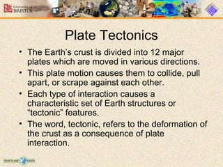
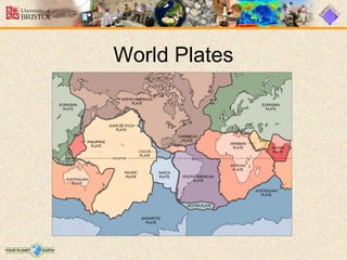
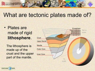
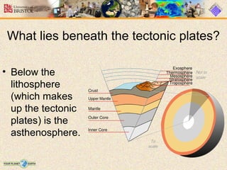
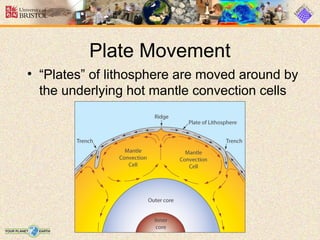
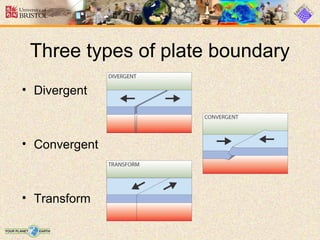
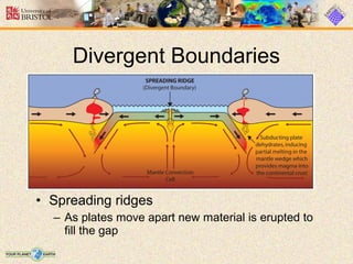
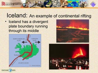
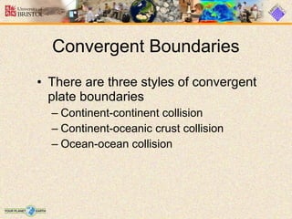
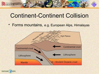
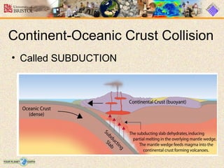
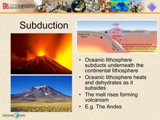
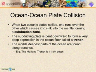
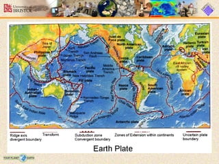
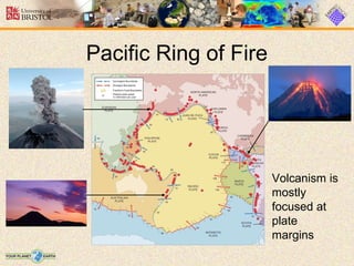
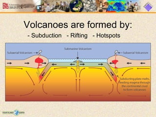
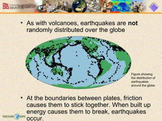
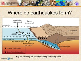
The Earth's crust is divided into tectonic plates that move due to convection currents in the mantle. There are three types of plate boundaries - divergent where new crust is formed, convergent where plates collide and one subducts under the other, and transform boundaries where plates slide past each other. Volcanoes and earthquakes occur predominantly at plate boundaries as a result of the movement and interaction of the plates.
Study of plate tectonics of the earth, or plate movement, Jahangir Alam
a) Wegener’s Evidence (Continental Drift)
b) History of Plate Tectonics
c) Breakup and Appearence of Pangea
WHAT IS A PLATE?
Major continental and oceanic plates include:
Types of Earth’s Crust:
Plate tectonics (from the Late Latin tectonicus) is a scientific theory which describes the large scale motions of Earth's lithosphere.
THE DYNAMIC EARTH:
The earth is a dynamic planet, continuously changing both externally and internally. The earth’s surface is constantly being changed by endo-genetic processes resulting in volcanism and tectonism, and exogenetic processes such as erosion and deposition. These processes have been active throughout geological history. The processes that change the surface feature are normally very slow (erosion and deposition) except some catastrophic changes that occur instantaneously as in the case of volcanism or earthquakes. The interior of the earth is also in motion. Deeper inside the earth, the liquid core probably flows at a geologically rapid rate of a few tenths of mm/s. Several hypotheses attempted to explain the dynamism of the earth.
+ Horizontal movement hypothesis
+ Continental drift, displacement hypothesis
Development of the plate tectonic theory.
Plate tectonic theory arose out of the hypothesis of continental drift proposed by Alfred Wegener in 1912. He suggested that the present continents once formed a single land mass that drifted apart, thus releasing the continents from the Earth's core and likening them to "icebergs" of low density granite floating on a sea of denser basalt.
Seafloor Spreading
The first evidence that the lithospheric plates did move came with the discovery of variable magnetic field direction in rocks of differing ages.
This Powerpoint Presentaion is used for my 11th Grade Earth Science Reporting as a major requirement for our sujbect. It talks about the tectonic processes and Plate boundaries with its theories..
Plate tectonics is the theory that Earth's outer shell is divided into several plates that glide over the mantle, the rocky inner layer above the core. The plates act like a hard and rigid shell compared to Earth's mantle. This strong outer layer is called the lithosphere.
Internal Structure of The Earth
Physical Layering
Determining the Earth's Internal Structure
C. The Earth's Internal Layered Structure and Composition
D. VELOCITY AND DENSITY VARIATION WITHIN THE EARTH
The immense amount of heat energy released from gravitational energy and from the decay of radioactive elements melted the entire planet, and it is still cooling off today. Denser materials like iron (Fe) sank into the core of the Earth, while lighter silicates (Si), other oxygen (O) compounds, and water rose near the surface.
The earth is divided into four main layers: the inner core, outer core, mantle, and crust. The core is composed mostly of iron (Fe) and is so hot that the outer core is molten, with about 10% sulphur (S). The inner core is under such extreme pressure that it remains solid. Most of the Earth's mass is in the mantle, which is composed of iron (Fe), magnesium (Mg), aluminum (Al), silicon (Si), and oxygen (O) silicate compounds. At over 1000 degrees C, the mantle is solid but can deform slowly in a plastic manner. The crust is much thinner than any of the other layers, and is composed of the least dense potassium (K), calcium (Ca) and sodium (Na) aluminum-silicate minerals. Being relatively cold, the crust is rocky and brittle, so it can fracture in earthquakes.
GOAL: To create a poster that explains the phenomena of blue sky using the concept of wavelength and frequency of visible light.
SITUATION: As the creative head in the science club of Macasandig National High School, you are tasked to create a poster showcasing the phenomena of blue sky on Science Club bulletin board.
PRODUCT: A creative poster explains the phenomena of blue sky. The poster should be in 1/8 illustration board.
faults generate earthquakes.
S8ES-IIa- 14
Objectives:
1. Describe what fault is and how these faults related to earthquakes.
2. Determine the extent of damage an earthquake can do in a particular location.
Article Reading
Earthquake wreaks havoc in the Philippines more than 1,000 people are killed when a 7.7-magnitude earthquake strikes Luzon Island in the Philippines on this day in 1990. The massive tremor wreaked havoc across a sizeable portion of Luzon, the country’s largest island, with Baguio City suffering the most devastating effects.
The epicenter of the quake, which struck at 4:26 p.m., was north of Manila in the Nueva Ecija province. Reports indicate that the shaking went on for nearly a full minute. Collapsing buildings were the main cause of damage and death. Getting out of a multi-story building was a good safety precaution that afternoon, although many people were injured and a few even died in stampedes of others doing the same thing.
At Christian College, a six-story building completely collapsed, trapping approximately 250 students and teachers inside. Heroic rescue efforts saved many, but some victims who did not die in the collapse were found dead later from dehydration because they were not pulled out in time.
All types of buildings, including several resort hotels in Baguio, known as the
Philippines’ Summer Capital, suffered tremendous damage. Most of the city’s 100,000
residents slept outdoors that evening and during the following week, afraid to return to
their homes amid the frequent aftershocks. For days, workers pulled bodies from the
demolished buildings in Baguio. The best estimate is that 1,000 bodies were eventually
recovered. At least another 1,000 people suffered serious injuries. Rescue efforts were
hampered severely because the three main roads into the city were blocked by landslides. Hundreds of motorists were stranded on the roads as well.
A fault is a fracture or zone of fractures between two blocks of
rock. Faults allow the blocks to move relative to each other.
This movement may occur rapidly, in the form of an earthquake - or may occur slowly, in the form of creep. Faults may range in length from a few millimeters to thousands of kilometers. Most faults produce repeated displacements over geologic time.
The ground in the area of fault tends to remain not moving
because of frictional force between the two opposing plates (boxes). As stronger forces (rubber band) shakes up the fault, the friction (tape) can no longer hold up the plates (box) thus resulting to a slip in the plates t
Francesca Gottschalk - How can education support child empowerment.pptxEduSkills OECD
Francesca Gottschalk from the OECD’s Centre for Educational Research and Innovation presents at the Ask an Expert Webinar: How can education support child empowerment?
Biological screening of herbal drugs: Introduction and Need for
Phyto-Pharmacological Screening, New Strategies for evaluating
Natural Products, In vitro evaluation techniques for Antioxidants, Antimicrobial and Anticancer drugs. In vivo evaluation techniques
for Anti-inflammatory, Antiulcer, Anticancer, Wound healing, Antidiabetic, Hepatoprotective, Cardio protective, Diuretics and
Antifertility, Toxicity studies as per OECD guidelines
Safalta Digital marketing institute in Noida, provide complete applications that encompass a huge range of virtual advertising and marketing additives, which includes search engine optimization, virtual communication advertising, pay-per-click on marketing, content material advertising, internet analytics, and greater. These university courses are designed for students who possess a comprehensive understanding of virtual marketing strategies and attributes.Safalta Digital Marketing Institute in Noida is a first choice for young individuals or students who are looking to start their careers in the field of digital advertising. The institute gives specialized courses designed and certification.
for beginners, providing thorough training in areas such as SEO, digital communication marketing, and PPC training in Noida. After finishing the program, students receive the certifications recognised by top different universitie, setting a strong foundation for a successful career in digital marketing.
Acetabularia Information For Class 9 .docxvaibhavrinwa19
Acetabularia acetabulum is a single-celled green alga that in its vegetative state is morphologically differentiated into a basal rhizoid and an axially elongated stalk, which bears whorls of branching hairs. The single diploid nucleus resides in the rhizoid.
Read| The latest issue of The Challenger is here! We are thrilled to announce that our school paper has qualified for the NATIONAL SCHOOLS PRESS CONFERENCE (NSPC) 2024. Thank you for your unwavering support and trust. Dive into the stories that made us stand out!
Introduction to AI for Nonprofits with Tapp NetworkTechSoup
Dive into the world of AI! Experts Jon Hill and Tareq Monaur will guide you through AI's role in enhancing nonprofit websites and basic marketing strategies, making it easy to understand and apply.
A Strategic Approach: GenAI in EducationPeter Windle
Artificial Intelligence (AI) technologies such as Generative AI, Image Generators and Large Language Models have had a dramatic impact on teaching, learning and assessment over the past 18 months. The most immediate threat AI posed was to Academic Integrity with Higher Education Institutes (HEIs) focusing their efforts on combating the use of GenAI in assessment. Guidelines were developed for staff and students, policies put in place too. Innovative educators have forged paths in the use of Generative AI for teaching, learning and assessments leading to pockets of transformation springing up across HEIs, often with little or no top-down guidance, support or direction.
This Gasta posits a strategic approach to integrating AI into HEIs to prepare staff, students and the curriculum for an evolving world and workplace. We will highlight the advantages of working with these technologies beyond the realm of teaching, learning and assessment by considering prompt engineering skills, industry impact, curriculum changes, and the need for staff upskilling. In contrast, not engaging strategically with Generative AI poses risks, including falling behind peers, missed opportunities and failing to ensure our graduates remain employable. The rapid evolution of AI technologies necessitates a proactive and strategic approach if we are to remain relevant.
Macroeconomics- Movie Location
This will be used as part of your Personal Professional Portfolio once graded.
Objective:
Prepare a presentation or a paper using research, basic comparative analysis, data organization and application of economic information. You will make an informed assessment of an economic climate outside of the United States to accomplish an entertainment industry objective.
Exploiting Artificial Intelligence for Empowering Researchers and Faculty, In...Dr. Vinod Kumar Kanvaria
Exploiting Artificial Intelligence for Empowering Researchers and Faculty,
International FDP on Fundamentals of Research in Social Sciences
at Integral University, Lucknow, 06.06.2024
By Dr. Vinod Kumar Kanvaria
2024.06.01 Introducing a competency framework for languag learning materials ...Sandy Millin
http://sandymillin.wordpress.com/iateflwebinar2024
Published classroom materials form the basis of syllabuses, drive teacher professional development, and have a potentially huge influence on learners, teachers and education systems. All teachers also create their own materials, whether a few sentences on a blackboard, a highly-structured fully-realised online course, or anything in between. Despite this, the knowledge and skills needed to create effective language learning materials are rarely part of teacher training, and are mostly learnt by trial and error.
Knowledge and skills frameworks, generally called competency frameworks, for ELT teachers, trainers and managers have existed for a few years now. However, until I created one for my MA dissertation, there wasn’t one drawing together what we need to know and do to be able to effectively produce language learning materials.
This webinar will introduce you to my framework, highlighting the key competencies I identified from my research. It will also show how anybody involved in language teaching (any language, not just English!), teacher training, managing schools or developing language learning materials can benefit from using the framework.
How to Make a Field invisible in Odoo 17Celine George
It is possible to hide or invisible some fields in odoo. Commonly using “invisible” attribute in the field definition to invisible the fields. This slide will show how to make a field invisible in odoo 17.
2. Structure of the Earth
• The Earth is
made up of 3
main layers:
– Core
– Mantle
– Crust
Inner core
Outer core
Mantle
Crust
3. The Crust
• This is where we live!
• The Earth’s crust is made
of:
Continental Crust
- thick (10-70km)
- buoyant (less dense
than oceanic crust)
- mostly old
Oceanic Crust
- thin (~7 km)
- dense (sinks under
continental crust)
- young
4. How do we know what the
Earth is made of?
• Geophysical surveys: seismic, gravity, magnetics,
electrical, geodesy
– Acquisition: land, air, sea and satellite
– Geological surveys: fieldwork, boreholes, mines
6. • If you look at a map of the world, you may notice that some of the
continents could fit together like pieces of a puzzle.
7. Plate Tectonics
• The Earth’s crust is divided into 12 major
plates which are moved in various directions.
• This plate motion causes them to collide, pull
apart, or scrape against each other.
• Each type of interaction causes a
characteristic set of Earth structures or
“tectonic” features.
• The word, tectonic, refers to the deformation of
the crust as a consequence of plate
interaction.
21. • Oceanic lithosphere
subducts underneath the
continental lithosphere
• Oceanic lithosphere heats
and dehydrates as it
subsides
• The melt rises forming
volcanism
• E.g. The Andes
Subduction
22. • When two oceanic plates collide, one runs over the
other which causes it to sink into the mantle forming
a subduction zone.
• The subducting plate is bent downward to form a very
deep depression in the ocean floor called a trench.
• The worlds deepest parts of the ocean are found
along trenches.
– E.g. The Mariana Trench is 11 km deep!
Ocean-Ocean Plate Collision
23.
24. • Where plates slide past each other
Transform Boundaries
Above: View of the San Andreas
transform fault
30. • Hot mantle plumes breaching the
surface in the middle of a tectonic plate
What are Hotspot Volcanoes?
Photo: Tom Pfeiffer / www.volcanodiscovery.com
The Hawaiian island chain are
examples of hotspot volcanoes.
31. The tectonic plate moves over a fixed hotspot
forming a chain of volcanoes.
The volcanoes get younger from one end to the other.
33. • As with volcanoes, earthquakes are not
randomly distributed over the globe
• At the boundaries between plates, friction
causes them to stick together. When built up
energy causes them to break, earthquakes
occur.
Figure showing
the distribution of
earthquakes
around the globe
35. Plate Tectonics Summary
• The Earth is made up of 3 main layers (core,
mantle, crust)
• On the surface of the Earth are tectonic
plates that slowly move around the globe
• Plates are made of crust and upper mantle
(lithosphere)
• There are 2 types of plate
• There are 3 types of plate boundaries
• Volcanoes and Earthquakes are closely
linked to the margins of the tectonic plates
Editor's Notes
The interior of the Earth is divided into layers based on chemical and physical properties.
The Earth has an outer silica-rich, solid crust, a highly viscous mantle, and a core comprising a liquid outer core that is much less viscous than the mantle, and a solid inner core.
Working from the centre of the Earth out we have:
The inner core is a primarily solid sphere about 1220 km in radius situated at Earth's center.
Based on the abundance of chemical elements in the solar system, their physical properties, and other chemical constraints regarding the remainder of Earth's volume, the inner core is believed to be composed primarily of a nickel-iron alloy, with small amounts of some unknown elements.
The temperature is estimated at 5,000-6,000 degrees Celsius and the pressure to be about 330 to 360 GPa (which is over 3,000,000 times that of the atmosphere!)
The liquid outer core is 2300 km thick and like the inner core composed of a nickel-iron alloy (but with less iron than the solid inner core).
Iseismic and other geophysical evidence indicates that the outer core is so hot that the metals are in a liquid state.
The mantle is approximately 2,900 km thick and comprises 70% of Earth's volume. (the core makes up about 30% of Earth's volume, with the outer crust [where we live] <1%!!).
The mantle is divided into sections based upon changes in its elastic properties with depth.
In the mantle, temperatures range between 500-900 degrees Celsius at the upper boundary with the crust to over 4,000 degrees Celsius at the boundary with the core.
Due to the temperature difference between the Earth's surface and outer core, and the ability of the crystalline rocks at high pressure and temperature to undergo slow, creeping, viscous-like deformation over millions of years, there is a convective material circulation in the mantle (mantle convection cells). Hot material rises up as mantle plumes (like a lava lamp!), while cooler (and heavier) material sinks downward to be reheated and rise up again.
- We shall see that this process is very important for plate tectonic motion…
The outer most layer is the crust - this is the most familiar to us as it is where we live.
The distinction between crust and mantle is based on chemistry, rock types and seismic characteristics.
Presenter: Ask the students to guess what the most abundant element in the earth’s crust is…..they may be surprised to learn that it is actually Oxygen (46.6% Oxygen; 27.7% Silica; 8.1% Aluminum; 5.0% Iron; 3.6% Calcium; 2.8% Sodium; 2.6% Potassium; 2.1% Magnesium; plus trace elements)
Click to next slide for more on the Crust….
The Earth has two different types of crust: Continental crust and Oceanic crust. Each has different properties and therefore behaves in different ways.
Continental crust:
Continental crust forms the land (the continents, as the name suggests) that we see today.
Continental crust averages about 35 km thick. Under some mountain chains, crustal thickness is approximately twice that thickness (about 70 km thick).
- The mountains we see on earth have deep roots in the crust that we can’t see. The crust “floats” on the more dense mantle and, like how only the tip of an iceberg sticks up out of the water, we see only the tip of the continental crust - the mountain ranges.
Continental crust is less dense and therefore more buoyant than oceanic crust
Continental crust contains some of the oldest rocks on Earth.
- Ancient rocks exceeding 3.5 billion years in age are found on all of Earth's continents. The oldest rocks on Earth found so far are the Acasta Gneisses in northwestern Canada near Great Slave Lake (4.03 Ga) [Ga = billion years ago] and the Isua Supracrustal rocks in West Greenland (3.7 to 3.8 Ga), but well-studied rocks nearly as old are also found in the Minnesota River Valley in the USA (3.5-3.7 billion years), in Swaziland (3.4-3.5 billion years), and in Western Australia (3.4-3.6 billion years).
Oceanic crust:
As the name already suggests, this crust is below the oceans.
Compared to continental crust, Oceanic crust is thin (6-11 km).
It is more dense than continental crust and therefore when the two types of crust meet, oceanic crust will sink underneath continental crust.
The rocks of the oceanic crust are very young compared with most of the rocks of the continental crust. They are not older than 200 million years.
If we can’t go to the centre of the Earth (except in fictional movies!) how do we know what the internal structure of the Earth is like?
We need to use geophysical imaging techniques to model what is going on below our feet.
For example, when there is an earthquake it sends out seismic waves (shock waves) through the Earth. Seismologists can measure the time it takes for these waves to reach seismic monitoring stations set up around the globe. (The machine that measures seismic waves is called a seismometer).
The different layers in the earth have been inferred using the time of travel of refracted and reflected (bent backward angularly) seismic waves created by the earthquakes (see left diagram). That is, changes in the seismic velocity occur as the waves pass through different materials. Measuring these changes tell seismologists how many layers there are and the thickness and physical properties of each layer.
We need not wait for earthquakes to occur, on a local scale on land (cheap but slow methods) and at sea (more expensive but quicker) explosions can be set to cause shock waves to pass through the crust (simulating an earthquake) that can be measured in the same way.
Other geophysical methods, for example measuring different gravity, magnetic and electrical anomalies by air and (or) satellite can help to reconstruct shallow crustal features.
We can also go and examine rocks at and near the surface of the crust, through fieldwork, drilling boreholes and mining.
Presenter: Ask the class if they have heard of Plate Tectonics before (commonly students will have some idea of the general concept), and ask them if they can explain the theory.
If you look at a map of the world, you may notice that some of the continents could fit together like pieces of a puzzle…..the shape of Africa and South America are a good example.
This is because they DID used to fit together!
The Earth as we see it today was not always like it is now. Land masses have pulled apart and joined together by the process we call Plate Tectonics….
There are 12 major plates on Earth, each of which slide around at a rate of centimetres per year, pulling away from, scraping against or crashing into each other.
Each type of interaction produces a characteristic “tectonic feature”, like mountain ranges, volcanoes and (or) rift valleys, that we will discuss during this lecture.
This diagram shows the major Tectonic Plates.
Presenter: Point out the UK, sitting on the Eurasian Plate. Also the plate boundary between Africa and South America (note that it has the same shape as the coastlines in these countries).
Plates are made of rigid lithosphere – formed of the crust and the extreme upper mantle (point out these layers on the figure).
The asthenosphere, beneath the lithosphere, is part of the upper mantle and is so hot that it is 1 – 5% liquid (I.e. 95 – 99% solid). This liquid, usually at the junctions of the crystals, allow it to flow – which is why ‘astheno’ means weak.’ Beneath the asthenosphere is the rest of the mantle, which is completely solid – but can also flow (on geological time scales) because of the intense temperatures and pressures involved.
The base of the lithosphere-asthenosphere boundary corresponds approximately to the depth of the melting temperature in the mantle.
How and Why do tectonic Plates move around?
The question of how tectonic plates are moved around the globe is answered by understanding mantle convection cells.
In the mantle hot material rises towards the lithosphere (like hot air rising out of an open oven - ever opened an oven door and felt the blast of hot air coming past your face?). The hot material reaches the base of the lithosphere where it cools and sinks back down through the mantle. The cool material is replaced by more hot material, and so on forming a large “convection cell” (as pictured in the diagram).
This slow but incessant movement in the mantle causes the rigid tectonic plates to move (float) around the earth surface (at an equally slow rate).
We are now going to discuss the processes that occur at plate tectonic boundaries. What happens when plates meet?
Firstly, there are three types of plate boundary, each related to the movement seen along the boundary.
Divergent boundaries are where plates move away from each other
Convergent boundaries are where the plates move towards each other
Transform boundaries are where the plates slide past each other.
Presenter: See diagrams for each - it is important to remember the names of the boundary types and the motion involved.
In plate tectonics, a divergent boundary is a linear feature that exists between two tectonic plates that are moving away from each other. These areas can form in the middle of continents or on the ocean floor.
As the plates pull apart, hot molten material can rise up this newly formed pathway to the surface - causing volcanic activity.
Presenter: Reiterate the process by going through the diagram, including the presence of mantle convection cells causing the plates to break apart and also as a source for new molten material.
Where a divergent boundary forms on a continent it is called a RIFT or CONTINENTAL RIFT, e.g. African Rift Valley.
Where a divergent boundary forms under the ocean it is called an OCEAN RIDGE.
Ocean Ridges: This map shows the age of the oceanic crust. The red colouring shows the youngest ages, whilst the dark blue shows the oldest ages (around 200 million years old).
Presenter ask: Where are the Ocean Ridges located? I.e. where are the divergent boundaries?
Answer: The divergent boundaries are where the plates are pulling apart and new material is being produced. Therefore the Ocean ridges are in the middle of the red areas (the boundaries are in fact shown on the map). We can see a progression of the oceanic crust getting older away from the ocean ridges (like a conveyer belt).
Presenter: Before moving on to the next slide, point out Iceland. The divergent boundary runs straight through Iceland….
Iceland is located right on top of a divergent boundary. In fact, the island exists because of this feature.
As the North American and Eurasian plates were pulled apart (see map) volcanic activity occurred along the cracks and fissures (see photographs).
With many eruptions over time the island grew out of the sea!
Question: Why don’t we have islands like Iceland where ever we get an Ocean Ridge?
Answer: Scientists believe that there is a large mantle plume (an upwelling of hot mantle material) located right underneath where Iceland has formed. This would mean that more material would be erupted in the Iceland area compared with if there was just the divergent boundary without the plume underneath it.
Convergent boundaries are where the plates move towards each other.
There are three types of convergent boundary, each defined by what type of crust (continental or oceanic) is coming together.
Therefore we can have: continent-continent collision, continent-oceanic crust collision or ocean-ocean collision….
When continental crust pushes against continental crust both sides of the convergent boundary have the same properties (think back to the description of continental crust: thick and buoyant). Neither side of the boundary wants to sink beneath the other side, and as a result the two plates push against each other and the crust buckles and cracks, pushing up (and down into the mantle) high mountain ranges. For example, the European Alps and Himalayas formed this way.
Example:
India used to be an island, but about 15 million years ago it crashed into Asia (see map).
As continental crust was pushing against continental crust the Himalayan mountain belt was pushed up.
“Mountains” were also pushed down into the mantle as the normally 35 km thick crust is approximately 70 km thick in this region.
Mt Everest is the highest altitude mountain on our planet standing 8,840 metres high. This means that below the surface at the foot of the mountain the crust is a further 61 km deep!!
At a convergent boundary where continental crust pushes against oceanic crust, the oceanic crust which is thinner and more dense than the continental crust, sinks below the continental crust.
This is called a Subduction Zone.
The oceanic crust descends into the mantle at a rate of centimetres per year. This oceanic crust is called the “Subducting Slab” (see diagram).
When the subducting slab reaches a depth of around 100 kilometres, it dehydrates and releases water into the overlying mantle wedge (Presenter: explain all of this using the diagram).
The addition of water into the mantle wedge changes the melting point of the molten material there forming new melt which rises up into the overlying continental crust forming volcanoes.
Subduction is a way of recycling the oceanic crust. Eventually the subducting slab sinks down into the mantle to be recycled. It is for this reason that the oceanic crust is much younger than the continental crust which is not recycled.
The Andes mountain range along the western edge of the South American continent is an example of a mountain belt formed by subduction.
The continental crust of the South American plate has buckled under the compressional strain of converging with the Nasca and Antarctic plates. Additionally there are many volcanoes, the result of melting of the subducting slab and the production of new material that has risen through the crust to the surface.
When two oceanic plates converge, because they are dense, one runs over the top of the other causing it to sink into the mantle and a subduction zone is formed.
The subducting plate is bent down into the mantle to form a deep depression in the seafloor called a trench.
Trenches are the deepest parts of the ocean and remain largely unexplored.
Manned or unmanned submersible vehicles (top right photo) have explored small parts of trenches discovering new species (like the fish photographed here) and amazing ecosystems.
The third type of boundary are transform boundaries, along which plates slide past each other.
The San Andreas fault, adjacent to which the US city of San Francisco is built is an example of a transform boundary between the Pacific plate and the North American plate.
This map summarises all the known plate boundaries on Earth, showing whether they are divergent, convergent or transform boundaries.
What’s the connection between volcanoes and plate tectonics….?
This map shows the margins of the Pacific tectonic plate and surrounding region. The red dots show the location of active volcanism. Notice how the majority of the volcanism is focused in lines along the plate boundaries? For this region this area is known as the “Pacific Ring of Fire”.
But why are all of the volcanoes located at the plate margins?
Volcanoes can be formed in three ways:
Via subduction. The subducting slab dehydrates to form new melt that will rise through the crust to be erupted at the surface.
Via rifting. When two plates pull apart magma rises, producing volcanic eruptions at the surface.
At “Hotspots”….hotspot do not necessarily occur along a plate boundary. So hotspot volcanoes can form in the middle of tectonic plates….Click for example.
Hotspot volcanoes in the middle of the Pacific plate.
Can anyone guess where they are?
Answer: Hawaii
Firstly, what are hotspot volcanoes and how do they form?
A hotspot is a location on the Earth's surface that has experienced active volcanism for a long period of time.
The source of this volcanism is a mantle plume of hot mantle material rising up from near the core-mantle boundary through the crust to the surface (see left diagram).
A mantle plume may rise at any location in the mantle, and this is why hotspot volcanoes are independent from tectonic plate boundaries.
The Hawaiian island chain are an example of hotspot volcanoes (see right photograph).
Hotspot’s commonly form volcanic island chains (like the Hawaiian islands). These result from the slow movement of a tectonic plate over a FIXED hotspot.
Persistent volcanic activity at a hotspot will create new islands as the plate moves the position of the “old” volcanic island from over the hotspot.
Therefore at one end of the island chain you see the youngest, most active volcanic islands (directly over the hotspot) and along the island chain the extinct volcanoes become older and more eroded (see diagram).
This way geologists can use hotspot volcano chains to track the movement of the tectonic plate through time.
We have seen the connection between volcanoes and plate tectonics.
Is there a connection between earthquakes and plate tectonics?
The black dots on this map of the world depict where earthquake activity is occurring. You can see that, as with volcanoes, the earthquakes are NOT randomly distributed around the globe. Instead they occur in linear patterns associated with plate boundaries.
(Note this diagram of earthquake distribution closely resembles the Pacific Ring of Fire distribution of volcanism).
We know there are three types of plate boundaries: Divergent, Convergent and Transform. Movement and slipping along each of these types of boundaries can form an earthquake.
Depending on the type of movement, the earthquakes occur in either a shallow or deep level in the crust.
The majority of tectonic earthquakes originate at depths not exceeding tens of kilometers.
In subduction zones, where old and cold oceanic crust descends beneath another tectonic plate, “Deep Focus Earthquakes” may occur at much greater depths (up to seven hundred kilometers!).
These earthquakes occur at a depth at which the subducted crust should no longer be brittle, due to the high temperature and pressure. A possible mechanism for the generation of deep focus earthquakes is faulting.
Earthquakes may also occur in volcanic regions and are caused there both by tectonic faults and by the movement of magma (hot molten rock) within the volcano. Such earthquakes can be an early warning of volcanic eruptions.
The take home messages from this lecture:
See if the students remember what each layer, type of plate and type of boundary are called.
Can they describe the motion of the three plate boundary types?
Where does volcanism occur in relation to plate tectonics?
Where do earthquakes occur in relation to plate tectonics?