CSEC Geography- Internal Forces - Plate Tectonics and Earthquakes
•
6 likes•1,375 views

This document looks at the Earth's internal forces. The main layers of the earth are described. The history surrounding plate tectonics is discussed. The different types of plate boundaries is also explained.

Recommended
More Related Content
What's hot
What's hot (20)
Similar to CSEC Geography- Internal Forces - Plate Tectonics and Earthquakes
Similar to CSEC Geography- Internal Forces - Plate Tectonics and Earthquakes (20)
More from Oral Johnson
More from Oral Johnson (20)
Recently uploaded
Recently uploaded (20)
CSEC Geography- Internal Forces - Plate Tectonics and Earthquakes
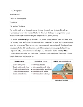
- 1. CSEC Geography Internal Forces Theory of plate tectonics O.Johnson The layers of the Earth The earth is made up of three main layers: the core, the mantle and the crust. These layers become denser towards the center of the Earth. Density is the degree of compactness, which increases with depth as a result of higher temperature and greater pressure. The crust is the thinnest layer of the Earth. The crust is usually between 10km and 60km thick. The crust thickness is often referred to as the relative thickness of an apple skin (when compared to the size of an apple). There are two types of crust, oceanic and continental. Continental crust is made up of silica (Si) and aluminium (Al) while oceanic crust is made up of silica (Si) and Magnesium (Ma). Continental crust is called (SIAL) and oceanic crust is called (SIMA). Oceanic crust is between 6 and 10 km thick. Continental crust can be up to 70km thick. Oceanic crust is denser than continental crust.
- 2. The mantle is the thickest layer of the Earth at 2,900km thick. It makes up nearly 80% of the volume of the Earth. The mantle itself is divided into 2 layers, the upper and lower mantles. The mantle is often described as being semi-solid or molten. Here we have magma that flows slowly due to the convection currents. The rocks in the upper mantle are cool and brittle enough to break under stress. Rocks in the lower mantle are hot and soft and flow rather than break. Differences in behaviour separate the upper from the lower mantle. The upper most part of the mantle and the entire crust makes up the rigid lithosphere. Below the lithosphere is a more mobile lower layer called the asthenosphere. At the centre of the earth is the core. The outer core is made of liquid iron and nickel. Heat from the core powers the convection currents in the mantle. The inner core is the hottest part of the Earth reaching temperatures between 4,000-4,700°C, which are as hot as the surface of the sun. It contains the centre of the earth which is about 6,378km from the surface. It is made of solid iron and nickel that are under so much pressure they cannot melt. The crust is very thin compared with the diameter of the Earth as whole. If a guava represented the earth, the skin of the guava would be about the thickness of the crust. However, the crust is not a continuous layer like the skin of a guava. Instead it is broken up into a number of large and small segments known as plates. The word tectonics comes from Greek; it means ‘building’. So plate tectonics means ‘plate building’.
- 3. History of theories For most of human history people had no idea that the positions of the continents had slowly changed over time. However, in 1912, Alfred Wegener published his theory of continental drift. He said that the continents had slowly drifted apart from one super-continent called Pangaea which existed 200 million years ago. The evidence for this included: The fit of continent- the ‘jigsaw’ effect Similar plant (India and Antarctica) and animal (South Africa and Brazil) fossils found in neighbouring continents now separated by water Rocks of similar type and age found at the edges of continents that could have once fitted together. The American Harry Hess then suggested that deep convection currents would force molten rock to well up just under the crust. Eventually the increasing pressure would crack the crust and force it apart. Research on rocks on the bed of the Atlantic Ocean in the 1960s supported Hess’s ideas. It became clear that the newest rocks were in the centre of ocean at the underwater mountain range known as the Mid-Atlantic Ridge, which is made up of volcanic rocks. The age of the rocks steadily increases with distance from the Mid-Atlantic Ridge.
- 4. In 1965 the Canadian geologist J. Wilson linked the ideas of continental drift and seafloor spreading. He introduced the idea of moving belts and rigid plates which formed the basis of the theory of plate tectonics. Why plates move Plates move because of what happens in the mantle below. The intense heat coming from the earth’s core causes the magma in the mantle to move very slowly in giant convection currents. These movements of magma are in places: Upwards towards the crust sidewards or horizontal to the crust downwards toward the core
- 5. These very powerful convection currents cause the plates of the earth’s crust to move. Where the movement is upwards plates are forced apart and new crust is formed. Where the movement is downward plates are brought together and plate material may be destroyed. Plate movement is usually continuous and it causes no problems on the surface of the earth. However, sometimes movement can be very sudden, causing earthquakes. Most earthquakes are small and have little effect on people. However, some are of great magnitude and have terrible consequences. Global distribution of plate boundaries There are seven very large or major plates: Pacific North American South American Eurasian African Indo-Australian Antarctic The smaller plates include the Nazca, Cocos, and Caribbean plates
- 6. Plates do not overlap. Where they are brought together by convection currents, once plate is either is forced down into the mantle and destroyed or they are both pushed upwards to form mountains. The SIMA which forms oceanic crust is denser than the SIAL of continental crust. The continental curst is permanent. In contrast, oceanic crust is always being formed in some places and destroyed in others. Oceanic crust is therefore younger than continental crust. In Greenland the continental crust is more than 3500 million years old but oceanic crust is nowhere older than 250 million years. The formation of new oceanic crust and the destruction of old oceanic crust is in balance as the Earth is neither shrinking nor expanding in size. Types of plate boundaries Transform plate boundaries Two plates slide last each other at a transform plate margins (also known as conservative plate boundary). Crust is either formed or destroyed nor there any volcanic activity. However major earthquakes can occur. Usually the plates slide past each other very slowly without any impact on the surface. But now and then the plates stick. When this happens huge pressure can build up. If the pressure is released suddenly an earthquake occurs. The plate margin is therefore conservative because crystal rocks are neither being destroyed or created.
- 7. This has happened many times along the San Andreas Fault in California. In 1906 San Francisco earthquake the surface moved by 6 meters. It measured 8.3 on the Richter scale. Over 450 people were killed and almost 30 000 buildings were destroyed. Convergent plate boundaries Convergent plate boundaries are also called destructive plate boundaries. This happen when two plates move towards each other. There are three types of convergence: Oceanic-Continental Continental-Continental Oceanic- Oceanic Oceanic-continental When an oceanic and a continental plate collide the denser, oceanic plate subducts beneath the lighter continental plate. A deep-sea trench or subduction occurs when the oceanic plate is forced downwards into the mantle. The increase in pressure along the plate boundary causes the descending plate to crack. This can cause large earthquakes.
- 8. The oceanic crust breaks up and melts to form new magma as it descends to great depths. This is due to friction and the very high temperatures as it enters the mantle. The newly formed magma is lighter than the mantle. Some of it may rise to the surface along lines of weakness in the continental crust If a lot of magma rises upwards volcanoes may be formed. The same process happens when the two plates are oceanic plates. The difference is that the older oceanic plate is going to be the denser one. There is still subduction and creation of magma. However the newly formed magma will rise through an oceanic crust to form volcanic island arcs (which are volcanic islands in water). The Windwards and Leeward Island are a good example of an island arc. The Peru-Chile trench is 8050 metres deep. The deepest in the world is the Mariana trench is the west Pacific Ocean which is 11 022 meters deep. Continental- Continental (Collision Zone) Sometimes two plates of continental crust come together. This is called a collision zone. Because continental crust cannot sink, the crust is forced upwards to form Fold Mountains. An example is the formation of the Himalayas Mountains. Here the Indian plate is still moving into the Eurasian
- 9. plate at 5cm a year. At times this movement causes major earthquakes. A long time in the past the sea of Tethys lay between the two land masses. But as the land masses slowly moved together the sea was squeezed out. The rock strata on the seabed were folded up to form mountains. Marine fossils found high in the Himalayas prove that these rocks were formed on the sea floor. The world’s highest mountains are in the Himalayas. Divergent plate boundaries Divergent plate boundaries (also known as constructive plate boundaries) occur when two plates move away from each other. New crust is formed at the boundary as magma moves up from the mantle below. When this happens underwater, it is described as sea-floor spreading. This happens at a number of places around the world, for example along the Mid-Atlantic Ridge. This huge underwater volcanic mountain range has been formed from magma coming from the mantle below. The lava has an unusual rounded shape and is called a pillow lava. As it oozes out along the plate boundary it cools quickly on the ocean bed. In places volcanic cones have built up along the ridge. Over time these submarine volcanoes may become large enough to reach the surface. This has happened in Iceland in the North Atlantic Ocean. The main island of Iceland was formed a long
- 10. time ago but in recent times two new small islands have appeared from below the sea. Surtsey was formed between 1963 and 1967, and Heimaey in 1973. Other islands along the Mid- Atlantic Ridge include the Azores, Ascension Island and Tristan da Cunha. Because of sea-floor spreading the Atlantic Ocean is being widened by 2-5cm a year. Almost three quarters of the lava that pours out onto the earth’s surface each year is found in mid-oceanic ridges. The other major mid-oceanic ridges are: East Pacific Pacific Antarctic Atlantic-Indian Carlsberg Mid-Indian. Where plates move apart on land, rift valleys are formed. In East Africa the African plate is splitting to form the Great African Rift Valley. It extends for 4000km from the Red Sea to Mozambique. Its width varies between 10 and 50 km and its sides are up to 600m above the floor. This rift valley is possibly the start of the formation of a new ocean as east Africa splits away from the rest of the continent.
- 11. The table below summarizes the relationship between earthquakes and volcanoes and the different types of plate boundary. Both can occur at convergent and divergent boundaries. However, earthquakes and volcanoes are at their most violent at convergent plate boundaries. Only earthquakes occur at collision zones and transform plate margins. Earthquakes Earthquakes result from a slow build- up of pressure along plate boundaries. This occurs where the plates ‘stick’. If this pressure is suddenly released, a violent jerking movement may occur on the surface. This is an earthquake. The point below the surface where the pressure is released is known as the focus. The point directly above the focus on the surface is the epicenter. The epicenter usually experiences the greatest shock or seismic waves. The vibrations due to seismic waves cause both vertical and lateral movements. These movements can create faults and cause partial or total destruction of buildings. The impact of an earthquake generally reduces with
- 12. distance from the epicenter. The energy released by an earthquake, described as the magnitude, is measured on the 10-point Richter scale. A large earthquake can be preceded by smaller tremors known as foreshocks and followed by numerous aftershocks. The man earthquake may last less than a minute but aftershocks can continue for several weeks afterwards. Following the earthquake in Kobe, Japan in 1995, which was 7.2 on the Richter scale, hundreds of aftershocks were recorded over a three-week period. Extracted from Guinness, P., Rocke, J., Nagle, G., Oliphant, K., Rae, A., Ross, S., … Wyllie, A. (2008). Geography for Csec. Nelson Thornes Ltd.