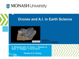
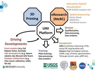
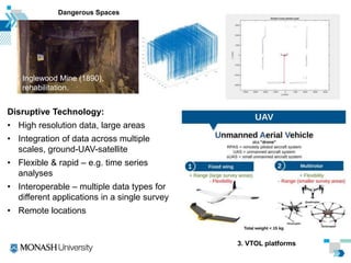
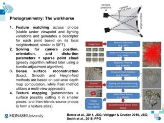
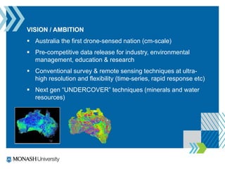
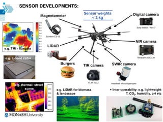
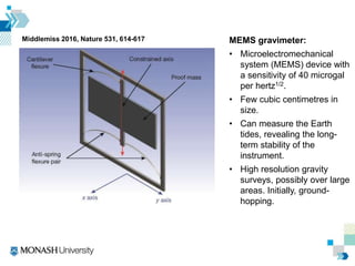
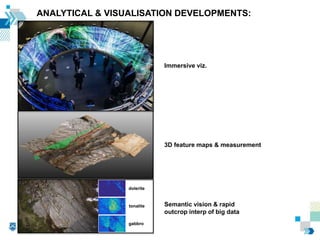
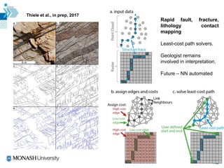
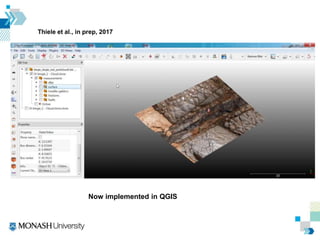
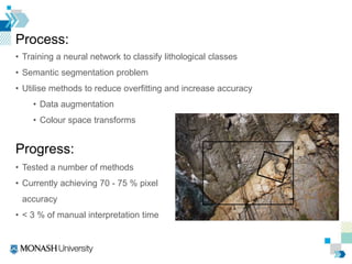
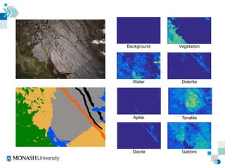
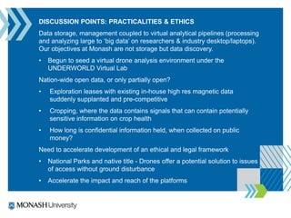
Drones and A.I. in Earth Science
S. Micklethwaite, S. Thiele, J. Sissins, A.
Spek, S. Vollgger, T. Drummond
Thanks to G. Dering
300x300 m,
25 mm pixel resolution
UAV
Platform
Training:
Pilots licencing,
Data processing,
Data analytics
Equipment:
UAVs (multirotor, fixed wing, VTOL,
heavy lift, long-duration etc),
Sensors (high-end digital cameras,
LiDAR, mag, infrared, spectrometers,
Temp-gas sensors, grav, pXRF etc),
Service:
Qualified pilots,
Data processing,
Data analytics
eResearch
(MeRC)
Spatial processing:
Nectar Cloud,
MASSIVE3,
Distributed servers
Interactive Spatial
Visualisation:
MIVP (CAVE2, headsets etc)
3D
Printing
Driving
Developments
Smart analytics (e.g. CoE
Robotic Vision, Sensilab)
UAV developments (e.g. Swarm
robotics lab, Monash UAS Team)
Strategic collaborations (e.g.
UTas sensor calibration, USGS,
GA etc)
Disruptive Technology:
• High resolution data, large areas
• Integration of data across multiple
scales, ground-UAV-satellite
• Flexible & rapid – e.g. time series
analyses
• Interoperable – multiple data types for
different applications in a single survey
• Remote locations
Dangerous Spaces
Inglewood Mine (1890),
rehabilitation.
3. VTOL platforms
ARC LIEF 2017 “UAV Sensing and Data
Discovery for a Changing Planet”
Photogrammetry: The workhorse
1. Feature matching across photos
(stable under viewpoint and lighting
variations and generates a descriptor
for each point based on its local
neighborhood; similar to SIFT).
2. Solving for camera position,
orientation, and distortion
parameters + sparse point cloud
(greedy algorithm refined later using a
bundle-adjustment algorithm).
3. Dense surface reconstruction
(Exact, Smooth and Height-field
methods are based on pair-wise depth
map computation, while Fast method
utilizes a multi-view approach).
4. Texture mapping (parametrizes a
surface possibly cutting it in smaller
pieces, and then blends source photos
to form a texture atlas).
Bemis et al., 2014, JSG; Vollgger & Cruden 2016, JSG;
Smith et al., 2016, PPG
• Impressive efficiencies but computationally expensive with
increasing surface area or GSD
• E.g. 2x images, 4x processing time
• A 8 km2 region at 5 cm pixel resolution, 3-5 days
• How to maximise analysis of this data in timely
manner?
Type of
lens (mm)
Number of
photographs
Quality Number of
Polygons
(Approx.)
Total
processing
time
(hours)
28 150-250 High 90000 5-8
Medium 40000 4-6
50 500-700 High 300000 30-35
Medium 160000 20-25
low 50000 10-15
105 600-700 Medium 250000 30-35
VISION / AMBITION
 Australia the first drone-sensed nation (cm-scale)
 Pre-competitive data release for industry, environmental
management, education & research
 Conventional survey & remote sensing techniques at ultra-
high resolution and flexibility (time-series, rapid response etc)
 Next gen “UNDERCOVER” techniques (minerals and water
resources)
+ Inter-operability: e.g. lightweight
T, CO2, humidity, pH etc
SENSOR DEVELOPMENTS:
e.g. thermal: street
scene
e.g. TMI - fluxgate
e.g. LiDAR for biomass
& landscape
e.g. L-band radar
Middlemiss 2016, Nature 531, 614-617 MEMS gravimeter:
• Microelectromechanical
system (MEMS) device with
a sensitivity of 40 microgal
per hertz1/2.
• Few cubic centimetres in
size.
• Can measure the Earth
tides, revealing the long-
term stability of the
instrument.
• High resolution gravity
surveys, possibly over large
areas. Initially, ground-
hopping.
ANALYTICAL & VISUALISATION DEVELOPMENTS:
Immersive viz.
3D feature maps & measurement
Semantic vision & rapid
outcrop interp of big data
dolerite
tonalite
gabbro
Thiele et al., in prep, 2017
Rapid fault, fracture,
lithology contact
mapping
Least-cost path solvers.
Geologist remains
involved in interpretation.
Future – NN automated
Thiele et al., in prep, 2017
Now implemented in QGIS
Process:
• Training a neural network to classify lithological classes
• Semantic segmentation problem
• Utilise methods to reduce overfitting and increase accuracy
• Data augmentation
• Colour space transforms
Progress:
• Tested a number of methods
• Currently achieving 70 - 75 % pixel
accuracy
• < 3 % of manual interpretation time
Vegetation
Dolerite
Tonalite
Background
Water
Aplite
Dacite Gabbro
DISCUSSION POINTS: PRACTICALITIES & ETHICS
Data storage, management coupled to virtual analytical pipelines (processing
and analyzing large to ‘big data’ on researchers & industry desktop/laptops).
Our objectives at Monash are not storage but data discovery.
• Begun to seed a virtual drone analysis environment under the
UNDERWORLD Virtual Lab
Nation-wide open data, or only partially open?
• Exploration leases with existing in-house high res magnetic data
suddenly supplanted and pre-competitive
• Cropping, where the data contains signals that can contain potentially
sensitive information on crop health
• How long is confidential information held, when collected on public
money?
Need to accelerate development of an ethical and legal framework
• National Parks and native title - Drones offer a potential solution to issues
of access without ground disturbance
• Accelerate the impact and reach of the platforms

Drones and A.I in Earth Science

  • 1.
    Drones and A.I.in Earth Science S. Micklethwaite, S. Thiele, J. Sissins, A. Spek, S. Vollgger, T. Drummond Thanks to G. Dering 300x300 m, 25 mm pixel resolution
  • 2.
    UAV Platform Training: Pilots licencing, Data processing, Dataanalytics Equipment: UAVs (multirotor, fixed wing, VTOL, heavy lift, long-duration etc), Sensors (high-end digital cameras, LiDAR, mag, infrared, spectrometers, Temp-gas sensors, grav, pXRF etc), Service: Qualified pilots, Data processing, Data analytics eResearch (MeRC) Spatial processing: Nectar Cloud, MASSIVE3, Distributed servers Interactive Spatial Visualisation: MIVP (CAVE2, headsets etc) 3D Printing Driving Developments Smart analytics (e.g. CoE Robotic Vision, Sensilab) UAV developments (e.g. Swarm robotics lab, Monash UAS Team) Strategic collaborations (e.g. UTas sensor calibration, USGS, GA etc)
  • 3.
    Disruptive Technology: • Highresolution data, large areas • Integration of data across multiple scales, ground-UAV-satellite • Flexible & rapid – e.g. time series analyses • Interoperable – multiple data types for different applications in a single survey • Remote locations Dangerous Spaces Inglewood Mine (1890), rehabilitation. 3. VTOL platforms
  • 4.
    ARC LIEF 2017“UAV Sensing and Data Discovery for a Changing Planet”
  • 5.
    Photogrammetry: The workhorse 1.Feature matching across photos (stable under viewpoint and lighting variations and generates a descriptor for each point based on its local neighborhood; similar to SIFT). 2. Solving for camera position, orientation, and distortion parameters + sparse point cloud (greedy algorithm refined later using a bundle-adjustment algorithm). 3. Dense surface reconstruction (Exact, Smooth and Height-field methods are based on pair-wise depth map computation, while Fast method utilizes a multi-view approach). 4. Texture mapping (parametrizes a surface possibly cutting it in smaller pieces, and then blends source photos to form a texture atlas). Bemis et al., 2014, JSG; Vollgger & Cruden 2016, JSG; Smith et al., 2016, PPG
  • 6.
    • Impressive efficienciesbut computationally expensive with increasing surface area or GSD • E.g. 2x images, 4x processing time • A 8 km2 region at 5 cm pixel resolution, 3-5 days • How to maximise analysis of this data in timely manner? Type of lens (mm) Number of photographs Quality Number of Polygons (Approx.) Total processing time (hours) 28 150-250 High 90000 5-8 Medium 40000 4-6 50 500-700 High 300000 30-35 Medium 160000 20-25 low 50000 10-15 105 600-700 Medium 250000 30-35
  • 7.
    VISION / AMBITION Australia the first drone-sensed nation (cm-scale)  Pre-competitive data release for industry, environmental management, education & research  Conventional survey & remote sensing techniques at ultra- high resolution and flexibility (time-series, rapid response etc)  Next gen “UNDERCOVER” techniques (minerals and water resources)
  • 8.
    + Inter-operability: e.g.lightweight T, CO2, humidity, pH etc SENSOR DEVELOPMENTS: e.g. thermal: street scene e.g. TMI - fluxgate e.g. LiDAR for biomass & landscape e.g. L-band radar
  • 9.
    Middlemiss 2016, Nature531, 614-617 MEMS gravimeter: • Microelectromechanical system (MEMS) device with a sensitivity of 40 microgal per hertz1/2. • Few cubic centimetres in size. • Can measure the Earth tides, revealing the long- term stability of the instrument. • High resolution gravity surveys, possibly over large areas. Initially, ground- hopping.
  • 10.
    ANALYTICAL & VISUALISATIONDEVELOPMENTS: Immersive viz. 3D feature maps & measurement Semantic vision & rapid outcrop interp of big data dolerite tonalite gabbro
  • 11.
    Thiele et al.,in prep, 2017 Rapid fault, fracture, lithology contact mapping Least-cost path solvers. Geologist remains involved in interpretation. Future – NN automated
  • 12.
    Thiele et al.,in prep, 2017 Now implemented in QGIS
  • 13.
    Process: • Training aneural network to classify lithological classes • Semantic segmentation problem • Utilise methods to reduce overfitting and increase accuracy • Data augmentation • Colour space transforms Progress: • Tested a number of methods • Currently achieving 70 - 75 % pixel accuracy • < 3 % of manual interpretation time
  • 14.
  • 15.
    DISCUSSION POINTS: PRACTICALITIES& ETHICS Data storage, management coupled to virtual analytical pipelines (processing and analyzing large to ‘big data’ on researchers & industry desktop/laptops). Our objectives at Monash are not storage but data discovery. • Begun to seed a virtual drone analysis environment under the UNDERWORLD Virtual Lab Nation-wide open data, or only partially open? • Exploration leases with existing in-house high res magnetic data suddenly supplanted and pre-competitive • Cropping, where the data contains signals that can contain potentially sensitive information on crop health • How long is confidential information held, when collected on public money? Need to accelerate development of an ethical and legal framework • National Parks and native title - Drones offer a potential solution to issues of access without ground disturbance • Accelerate the impact and reach of the platforms