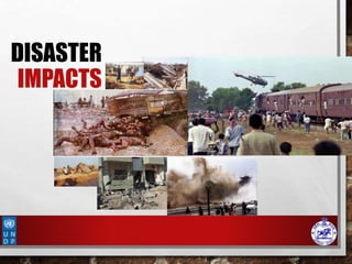
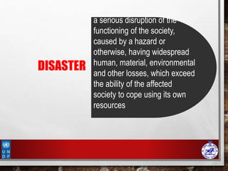
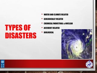
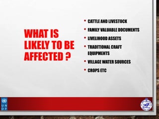
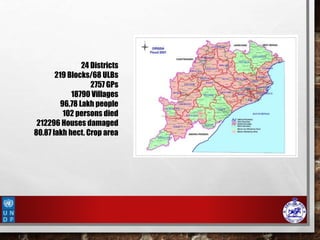
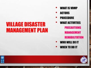
A serious disruption of the functioning of the society, caused by a hazard or otherwise, having widespread human, material, environmental and other losses, which exceed the ability of the affected society to cope using its own resources
Good governance, equitable adaptation & building coalitions around climate change. Presented by Edith Fernandez-Baca at the "Perth II: Global Change and the World's Mountains" conference in Perth, Scotland in September 2010.
White paper-Sustainable Community Planning - TRACT ConsultingTRACT Consulting
This document discusses sustainable planning for municipalities in Newfoundland and Labrador. It argues that sustainable planning is needed to manage future change in a comprehensive, integrated, and inclusive manner by balancing environmental, economic, social, and cultural considerations. The document outlines how sustainable planning can help communities use resources wisely, preserve valued areas, make efficient use of developable land, and enhance quality of life. It emphasizes the importance of involving local residents and having an inventory of the local land base to inform planning decisions.
The document summarizes the planning process for the new capital city of Naya Raipur in Chhattisgarh, India. Key factors in selecting the site included good transportation connectivity, availability of government land, favorable environmental and drainage conditions, and proximity to existing economic centers. The planned development of Naya Raipur includes government complexes, cultural centers, residential and commercial areas, universities, parks, and transport infrastructure. Individual construction projects within the city will require separate environmental clearances. The state environmental authority has granted provisional approval for the overall development plan while prescribing conditions to mitigate environmental impacts.
This document provides an overview of rural and urban environments. It defines key terms and discusses the characteristics of each environment. Rural environments typically have lower population densities, less pollution, and more greenery and contact with nature. Urban environments are marked by higher population densities, more development, infrastructure and pollution as well as less greenery. The ecological footprint is typically higher for urban versus rural environments due to greater resource consumption and waste generation in cities.
This document proposes creating a Federal Green Infrastructure Community of Practice (CoP) to benefit the Metro Atlanta area. A survey of 10 federal agencies found differing definitions of green infrastructure and identified needs like education, funding opportunities, and planning models. The CoP would allow federal staff to share expertise, collaborate, and promote a consistent approach to incorporating green infrastructure at all scales. Doing so could provide environmental, social, and economic benefits to the Atlanta region through services like improved water quality and increased recreation. Next steps proposed forming a steering committee and focusing initial CoP discussions on projects within Atlanta.
The document summarizes the Risk Reduction Index (RRI) methodology and preliminary findings from its phase II study in West Africa. The RRI assesses capacities and conditions for disaster risk reduction in vulnerable countries. In Ghana, the RRI analyzed 3 representative territorial units (RTUs): Accra, Bolgatanga, and the East Coast. Preliminary findings show the main challenge across RTUs is environmental/natural resource management. Soil erosion and water contamination were also key issues. The RRI will continue data analysis, workshops, and action planning in West Africa and begin phase III in Asia.
The document provides details about the 2012 Annual Conference of the Massachusetts Association of Planning Directors (MAPD) to be held on June 7-8, 2012 in Springfield, Massachusetts. The conference will include sessions on topics such as open space subdivision development, land use ethics, public infrastructure funding, innovative zoning, and lessons learned from storms. It provides an agenda with session details, speaker biographies, logistical information and registration details. The high-level purpose is to provide continuing education for planners on relevant topics through a multi-day event in Springfield.
This document discusses solid waste management in the Tamale Metropolitan Area (TAMA) in Ghana. It aims to examine the factors affecting effective solid waste management and suggest measures to address the problems. TAMA faces issues with indiscriminate dumping, irregular waste collection, and inadequate resources for waste management. Approximately 810 tonnes of waste are generated daily in TAMA, but only 216 tonnes are collected, leaving 594 tonnes uncollected. This has resulted in litter, overflowing skips, and unclean areas. The study seeks to understand the types and sources of waste generated, how waste is disposed of by households, the frequency and process of waste collection, and the capacity of waste management institutions to address the problems.
This document is a dissertation submitted by Natamba Shadrack to Uganda Christian University in partial fulfillment of the requirements for a Master's degree in Development Studies. The dissertation examines waste management in urban areas in Uganda, using Kyazanga Town Council in Lwengo District as a case study. It aims to establish the underlying causes of poor waste management in the town council and seek opinions on how to solve the problem. The dissertation includes a literature review on waste management, methodology using mixed methods of data collection, findings on the causes of poor waste management in Kyazanga, and recommendations to address the issues.
The document summarizes concerns about the proposed Beaver Valley Village subdivision development relating to groundwater uncertainty, risk of cumulative negative impacts, and density. It notes that local experience and peer review recommendations have not been adequately considered. There are concerns that the development may negatively impact groundwater quality and quantity in the area. It recommends that more studies be conducted on potential cumulative impacts and that the municipality implement a groundwater management plan before approving further developments.
FIVAS (Foreningen for Internasjonale Vannstudier) 2010. Rapporten tar for seg den pågående satsingen på vannkraftutbygging i Guatemala, viser hva som kan gå galt og hva som må tas hensyn til i fattige land, og land med sårbare grupper slik som urfolk. Rapporten er også tilgjengelig på spansk.
Decision support system for Local Level Agencies and Communities Disaster Ris...practicalanswerssl
This is an introductory presentations to the pilot project on DRSLUP methodology implemented in Ambalantota DS Division in Hambantota District in Sri Lanka by Practical Action Sri Lanka
The document discusses disaster management and preparedness for cyclones. It outlines key elements at risk from cyclones like housing, crops, and infrastructure. Effective preparedness requires assessing vulnerabilities, planning response mechanisms, and educating the public. Response activities during a cyclone include evacuation, search and rescue, emergency relief, and expediting post-disaster rehabilitation and reconstruction. Preparedness aims to minimize losses by taking precautionary actions and ensuring timely emergency response.
1) The document summarizes a capacity building workshop held by Raks Thai Foundation on climate change negotiation processes.
2) Raks Thai Foundation works on programs related to natural resources, disaster response, health, education, and empowering women in southern Thailand.
3) The workshop discussed case studies of community-based disaster risk management (CBDRM) in two districts in Krabi Province, including the multi-hazard impacts faced by communities and CBDRM project activities implemented in response.
The document outlines the roles and responsibilities of major stakeholders in integrated water resources management (IWRM) in the Hadejia-Jama'are-Komadugu-Yobe River Basin (HJKYB). It identifies the following stakeholder groups in HJKYB: resource users, government agencies, legislative houses, community-based and research institutions, media organizations, non-governmental organizations, externally supported agencies and donor projects, and regional organizations. It then discusses the IWRM framework, challenges in HJKYB, strategies for transitioning to IWRM, and a 10-step process for developing an IWRM plan for the basin.
The document discusses how information and communication technologies (ICT) can help reduce climate change. It notes that climate change is a major threat, negatively impacting over 2 billion people through issues like water stress, displacement, and malnutrition. Bangladesh is particularly vulnerable, with its government investing over $10 billion to combat problems from floods, cyclones, and droughts exacerbated by climate change. The presentation argues that ICT can help address these challenges through applications that support climate change mitigation and adaptation, empower vulnerable populations, and increase awareness of solutions. Key priorities include recognizing ICT's role in policy, fostering partnerships for innovation, and localizing projects to build community ownership.
Municipal officials in the Hudson Valley region of New York face barriers in adapting to increased flooding from climate change. Over half of officials are still in the understanding phase of adaptation. The most common barriers are lack of funding, complex government regulations, and lack of knowledge about local flood risks and options. Officials have taken some actions like emergency planning but need more information and partnerships to advance planning. Educational workshops effectively increased officials' knowledge of proper stream management techniques. Future efforts should provide data on local climate impacts and help navigate resources to support adaptation.
This document provides an overview of the Community Resilience Linking Livelihoods event taking place on February 13-14, 2015 in Patna, Bihar. It discusses key concepts around building community resilience, including local focus, capacity building, adapting from relief to sustainable practices, and linking community efforts to national programs. It also summarizes the work of UDYAMA, an organization working on community resilience and livelihood programs in Odisha, India, including their community interventions, key results, and relationship with local and international partners and initiatives. The document outlines some of the climate change and other risks faced in Odisha and discusses UDYAMA's approach to building resilience through micro-planning, watershed management
The document discusses the need for a high seas biodiversity agreement to protect international waters, which cover two-thirds of the planet. It notes that 90% of big fish have been overfished, coral reefs are disappearing, and climate change is altering ocean chemistry. While less than 1% of the high seas are protected, these waters are facing increasing threats from human activities like overfishing, pollution, and climate change. The document argues that governments should approve negotiations on a new agreement at Rio+20 to implement relevant provisions of the UN Convention on the Law of the Sea and establish protections for biodiversity in international waters. Doing so could boost fisheries, jobs, and the overall ocean economy while safeguarding ocean resources
This document discusses requirements collection for a solid waste management project in Addis Ababa, Ethiopia. It outlines three chapters: solid waste management problems and solutions, requirements collection focus areas, and project budget estimation. The requirements collection will benchmark other cities, consult stakeholders, identify innovative solutions, and define community education. Focus areas are urban settlements, schools, and houses. Data will be collected through interviews and observations. A work breakdown structure outlines the project timeline. The estimated budget is 71,775,000 Birr to address stakeholder meetings, materials preparation, and implementation costs over 30 weeks.
Indonesia Water Supply and Sanitation Magazine. 'PERCIK' Vol 6 October 2004Oswar Mungkasa
This document provides information on various topics related to drinking water and sanitation in Indonesia. It includes the main feature article on drinking water still being a dream in Indonesia and the challenges faced by local water companies (PDAMs) in providing drinking water services. It also interviews the head of the water company association who discusses ideas around subsidizing drinking water. Additional articles explore strategies for improving community awareness of water issues and the experiences of specific PDAMs in expanding services. The document aims to raise awareness of drinking water and sanitation challenges in Indonesia and policies to work towards meeting national and international goals.
Humboldt County Firewise Mapping Project - Final reportJerry Dinzes
Prepared by Humboldt State students, this report discusses the benefits of Firewise mapping and community fire management programs. Prepared By: Jerry Dinzes, Eileen Nunez, Chibu Okezie, Hether Ward
Major natural disasters that have affected Bangladesh between 1974 and 2009 include floods, cyclones, tornadoes, droughts, and earthquakes. The most devastating floods occurred in 1988, 1998, and 2004, killing over 3,000 people and causing billions of dollars in economic losses. Cyclones in 1991 and 2007 also killed over 150,000 people and caused billions in damages. Tornadoes have locally destroyed homes and infrastructure. Famine in 1974 resulted in 1.5 million deaths. These frequent natural disasters have significantly impacted lives, the economy, and environment in Bangladesh.
The overall goal of this project was to develop an implementation framework for an offsite BMP program
to maximize the environmental and economic effectiveness with which the City of Wichita meets its
NPDES stormwater permitting requirements to ultimately improve water quality in the Little Ark and
Arkansas Rivers. This program aims to integrate watershed stakholders across sociopolitical bounds and
provide a sustainable funding mechanism to implement and maintain water quality practices in the rural
landscape, a critical need as watershed managers struggle to meet water quality targets (e.g., TMDLs).
Based on dialogue between stakeholders representing the watershed’s agricultural (represented by the
Little Ark Watershed Restoration And Protection Strategy program, or WRAPS) and urban (represented by
the City of Wichita’s Stormwater Advisory Board and City officials) communities and the Kansas
Department of Health and Environment (KDHE), which administers TMDLs and water quality permits, the
program works to optimize the placement of BMPs within the watershed for maximum water quality
benefit of the integrated system. Rural management practices tend to be less costly, thereby enabling
greater pollutant load reduction per dollar spent on BMPs in rural versus urban areas. For this reason, net
costs to urban developments participating in the offsite program should be significantly less than if
traditional urban water quality control practices were installed and maintained. A program framework was
developed in which a “sediment credit” fee is paid annually by urban developments participating in the
program to finance implementation and maintenance of offsite BMPs as facilitated through the Little
Arkansas WRAPS program. Adoption of this offsite program is anticipated to lead to greater reductions in
sediment (and other pollutant) loads leaving the watershed than could be achieved through conventional
implementation of BMPs within urban bounds to meet MS4 permit requirements. The program is currently
in its first year of implementation.
Drr and cca learnings from banganga river basin kapilvastu ndrc nepalDPNet
LEARNING TO LEAD:
Building Resilience to Disaster and
Climate Change Impacts on Women and Children Project - An Experience from Banganga River Basin, Kapilvastu, Nepal
The document summarizes a watershed development program that aims to address depleting natural resources and poverty through various initiatives:
1. Watershed management using continuous contour trenching (CCT) technology and plantation across several sites.
2. Training local communities on the use of CCT technology and conducting field training for students.
3. Creating water literacy through educational lectures on water and soil conservation.
4. Demonstrating the use of contour markers and selling them to government departments and private organizations.
The document summarizes the Sustainable Sites Initiative, which provides standards for sustainable landscaping practices that can earn points in the LEED program. Some key points of the initiative include minimizing water and resource usage, controlling invasive species, increasing plant biomass to offset emissions, and using native plants to support biodiversity. It also emphasizes enhancing human health through views of nature, outdoor spaces for activity and gathering, and using landscaping like retention ponds as amenities. Overall, the initiative aims to restore natural systems, prioritize materials reuse and recycling, and support long-term sustainable site maintenance and operations.
This document provides background on Dr. Jacqueline Comito, an anthropologist at Iowa State University Extension and Outreach. It discusses her work in conservation outreach programs over the past 14 years, including establishing conservation learning groups, producing educational videos and podcasts, and leading youth water education programs. The document also analyzes conversations with various agricultural stakeholders to understand motivations and barriers to conservation practices. Key topics covered include nature and culture, place and space, encouraging moments of awe, and the importance of local grassroots communication in creating a culture of conservation.
ADB’s Adaptation Program: Poverty Implications and Emerging ResponsesPoverty Environment Net
This document summarizes ADB's efforts to address the poverty implications of climate change through adaptation programs. It finds that vulnerable groups like the poor, women, children and ethnic minorities will be most severely impacted. Case studies from Vietnam show climate change could increase poverty levels significantly in the Mekong Delta. ADB is working to incorporate vulnerability assessments and adaptation options into projects and strategies to make them more climate-resilient and reduce poverty impacts over the long run. Priority areas of focus include climate-proofing infrastructure, analyzing vulnerable sectors and locations, and building staff and local capacity on adaptation and financing approaches.
Climate responsive urban development revisionrachit pamnani
This document summarizes a vulnerability analysis of Hyderabad city in India. It identifies several climate hazards the city faces, such as earthquakes, cyclones, and flooding due to heavy rainfall. It analyzes factors like temperature, precipitation, population density, water and air quality, and the effects of natural habitat loss. Several areas in Hyderabad are found to be highly flood-prone due to encroachment on water bodies. The analysis also examines Hyderabad's housing conditions and the status of slums in the city. Identifying vulnerable zones is important for developing climate-responsive urban planning and infrastructure for the growing city.
Synergy in Integration - Institutional Mechanism for Managing Hydrological Ex...Global Water Partnership
This document summarizes a workshop on managing hydrological extremes like floods and droughts in Pakistan. It discusses how water is central to socioeconomic development and food security. It notes that climate change is expected to increase the frequency and severity of extreme water events in Pakistan. The document calls for moving beyond structural measures to also implement non-structural initiatives. It emphasizes the need to update Pakistan's national water sector data and models to better manage floods and droughts under climate change.
This document provides an overview of coastal urban flood risk management. It discusses the increased occurrences of floods and their threat to coastal areas. The need to integrate risk management and development approaches is highlighted. Asia has seen a rising trend in flood disasters compared to other disasters in the last 28 years. Coastal cities like Kolkata and Mumbai have high percentages of their areas at risk of flooding. The aim of the study is to plan for resilient urban developments through a flood risk management approach. Objectives include understanding causes and impacts of floods, studying regulations and plans, and applying a Coastal Disaster Risk Index to propose an adaptive strategy for Kochi, India. The scope is a city-level analysis and limitations include data accuracy and quality
1. The village disaster management plan outlines how the village will prepare for and respond to disasters by assessing hazards, vulnerabilities, and capacities.
2. It establishes response teams and assigns them roles in warning people, evacuating, providing first aid, sanitation, shelter management, relief, and damage assessment.
3. The plan also includes mitigation and preparedness measures like identifying evacuation routes and conducting drills, as well as utilizing existing financial mechanisms for disaster management and community resilience.
Disaster risk reduction practices in bangladeshJahangir Alam
Bangladesh
DRR concept
Evolving Paradigms of DM
Actions and Strategies on DRR
Working with Community
Gaps, Concerns, Limitations & Challenges
Learning and Observation
Step Forward
DP ?New generation DRR Practitioner
GANDHI? Conclusion
Bangladesh:
B-Bay of Bengal
A- Agriculture
N-NGOs
G-Garments and GB
L-Land of Rivers
A-Adaptability
D-Disasters, DM, Democracy
E-Emergency
S-SAARC
H-High: Population growth, Vulnerabilities
Good Governance: A pathway to local resilienceCARE Nicaragua
Partners for Resilience (PfR) in Nicaragua has been promoting comprehensive approaches to disaster risk reduction, climate change adaptation, and ecosystem management since 2011. Through community assessments and dialogue arenas, PfR has supported the development and implementation of management plans and strategies to increase resilience at the local level. Key activities included strengthening community self-management, implementing community microprojects, and producing tools to inform land use planning. By linking actors and facilitating coordination between communities and local governments, PfR has helped ensure municipal responses address community needs and priorities. Lessons learned indicate developing national and local government programs and strategies, facilitating multi-sector dialogue, and systematically interacting among stakeholders has been important to the success and impact of PfR's
UDYAMA works in Odisha, India with communities to build resilience. It focuses on local capacity building, changing from relief to addressing underlying causes, ecosystem approaches, advocacy, and linking local and global initiatives. The report summarizes UDYAMA's work demonstrating community management of disaster funds, reaching over 100,000 people across multiple districts. Key activities include baseline assessments, resilience planning, training women's groups, and developing community assets to reduce vulnerability.
Green Strategies for Controlling Stormwater and Sewer OverflowSotirakou964
This document discusses the growing problem of urban stormwater and combined sewer overflows (CSOs) and promotes green infrastructure as an effective solution. It contains the following key points:
1. Impervious surfaces in urban areas have increased runoff and pollution, threatening water quality. Green infrastructure like trees and permeable pavement intercepts rainfall and reduces runoff at its source.
2. Case studies show green infrastructure can cost-effectively control stormwater and CSOs while providing additional benefits like improved air and water quality. Cities have established programs using techniques like green roofs, rain gardens, swales, and downspout disconnection.
3. Wider adoption of green infrastructure faces obstacles
Urbanization has significantly increased the amount of impervious surfaces like roads and buildings, altering the natural water cycle. Over 100 million acres in the US are now developed. This causes more stormwater runoff, carrying pollutants directly into waterways. Current stormwater infrastructure is inadequate, as it was designed only to convey runoff efficiently rather than treat pollution. As a result, stormwater is the top pollution source for over half of ocean shorelines and a third of estuaries. Combined sewer overflows also introduce untreated sewage during heavy rains. New approaches are needed to manage stormwater sustainably.
1) A disaster is defined as any event that causes damage, ecological disruption, loss of life, deterioration of health services, and warrants an extraordinary response. Disaster management aims to minimize deaths and losses through preparedness and planning.
2) Key factors that affect disasters include population growth, poverty, rapid urbanization, and environmental degradation. Disaster management involves preparing for, responding to, and rebuilding after natural and human-made disasters.
3) India's National Disaster Management Authority oversees various agencies that are responsible for forecasting and responding to different disaster types such as floods, cyclones, earthquakes, and epidemics.
1) A disaster is defined as any event that causes damage, ecological disruption, loss of life, deterioration of health services, and warrants an extraordinary response. Disaster management aims to minimize deaths and losses through preparedness and planning.
2) Key factors that affect disasters include population growth, poverty, rapid urbanization, and environmental degradation. Disaster management involves preparedness, response, recovery and rebuilding after natural or human-made disasters.
3) India has established agencies and plans to manage different disaster types through various ministries and organizations. Nodal agencies coordinate response while the National Disaster Management Authority oversees overall coordination and policy.
Traveston Dam: The Ramsar Ramificationsgreatermary
The document discusses several key points regarding intergenerational equity and Ramsar wetlands:
1) Ramsar assessments of impacts on wetlands should consider both the local ecosystem scale and broader scales like the entire river basin or migratory range of affected species.
2) Environmental impact assessments must be fully incorporated into existing legal planning processes rather than seen as separate add-ons.
3) Assessments should use the ecosystem approach and consider proper temporal and spatial scales, biodiversity values, and stakeholder participation.
4) The EIS fails to adequately address policies in various plans regarding protection of wetlands, water resources, biodiversity, and coastal environments.
This document summarizes a presentation on climate change adaptation planning and Massachusetts policy updates. It discusses the impacts of climate change on natural resources, human health, infrastructure, and the economy in the Northeast US. Adaptation means increasing community resiliency by reducing vulnerability. The presentation covers landscape-level planning, improving infrastructure resiliency, sustainable building practices, and Massachusetts legislation on comprehensive adaptation planning and funding support for these efforts.
The document discusses mainstreaming disaster risk reduction into sustainable national water resources development programs in Nigeria. It outlines challenges to water resources management in Nigeria including devastating erosion, perennial flooding, recurring droughts and increasing desertification. The national approach to reducing water resources management related disasters includes the National Water Policy and National Erosion and Flood Control Policy. Integrating disaster risk reduction concerns into integrated water resources management requires strengthening institutions and legal frameworks. The document recommends promoting integrated water resources management planning and developing national disaster prevention and response systems to institutionalize disaster risk reduction in water resources development.
Workbook for Measuring Resilience at the Communities and Link to Local Govern...Rustico Biñas
This workbook is intended to guide communities, staffs of government agencies and Non-Government agencies in Disaster Risk Assessment and Analysis (Hazard characterization, Vulnerability Assessment, Capacity Assessment), developing resilience monitoring and evaluation indicators and a hazard specific Development Plan and Contingency Plan in the community and link to Municipal/Provincial level. This workbook provides exercise sheets and formats to identify hazard specific disaster risk reduction measures.
The document discusses barriers to adopting Low Impact Development (LID) practices in municipal codes in Bay Area cities. It analyzed the codes of San Jose, Hayward, San Rafael, San Mateo, and Pleasanton and found opportunities to better incorporate LID. Key barriers included standards that require excessive impervious surfaces and lack flexibility. Adopting LID practices like minimizing pavement and clustering development could help cities improve stormwater management and water quality as required by regulations.
Similar to Community Based Disaster Management (20)
U.S.A and India: Convergences and Challenges in Clean Energy and Climate Ch...Bibhuti Bhusan Gadanayak
U.S.A and India: Convergences and Challenges in Clean Energy and Climate Change
Key discussion questions
- What are the challenges faced by both countries in harnessing the true potential for clean energy?
- Should the issue of climate change feature as a major theme in the bilateral strategic negotiations?
- How can knowledge sharing platforms be utilised to mitigate the crisis of climate change?
- What does US joining of India-led International Solar Alliance means for the grouping?
Social development is about improving the well-being of every individual in society so they can reach their full potential.
-The success of society is linked to the well-being of each and every citizen. Social development means investing in people.
Disaster Management: Definition, Typology of disasters, major disasters in India
Disaster Management Cycle: Paradigm Shift in Disaster Management, Pre-Disaster – Risk Assessment and Analysis, Risk Mapping: Zonation and Microzonation, Prevention and Mitigation of Disasters, Early Warning System; Preparedness, Capacity Development; Awareness. During Disaster – Evacuation – Disaster Communication – Search and Rescue – Emergency Operation Centre – Incident Command System – Relief and Rehabilitation.
Post-disaster – Damage and Needs Assessment, Restoration of Critical Infrastructure – Early Recovery – Reconstruction and Redevelopment.
Natural Disaster – Definition and associated terminology, Complex Humanitarian Emergency
Origin and evolution of the definition, difference between man-made and natural disasters: characteristics
Concept, nature and severity of climate change.
Causes of climate change. Impact of climate change: globally in general and Odisha in particular.
Greenhouse effect, climate change and disasters.
Role of Civil Society in DRR Implementation of the SFDRR in the context of U...Bibhuti Bhusan Gadanayak
All non-governmental groups, associations and institutions that citizen form and join these includes
- religious organizations
- professional organizations
- charitable groups
- inter groups
Non-Governmental associations (NGOs)
Role of women in disaster management Experience from Asia and Africa presente...Bibhuti Bhusan Gadanayak
Role of women in disaster management
Experience from Asia and Africa
"To awaken the people, it is the women who must be awakened. Once she is on the move, the family moves, the village moves, the nation moves".
Pt. Jawaharlal Nehru
1.Enabling children and adults to access the resources they need to maintain their health and wellbeing (e.g., under lockdown or shielding) through
2.Enabling children and adults to access the resources they need to maintain their health and wellbeing (e.g., under lockdown or shielding) through
3.Identifying and supporting informal family and friend
Mobilizing, connecting people and providing information about community, universal and secondary services and resources
Social workers played several important roles during the COVID-19 pandemic. They helped clients navigate constant changes to guidelines by staying updated on new resources. Social workers educated communities on stopping the spread of the virus and provided clear guidance. They also guided self-care during the pandemic's uncertainty and supported recovery efforts as the crisis eased. Looking ahead, social workers will focus on preparedness, community resilience, and learning from the COVID-19 experience to improve social work practices and services.
The Post-Disaster Needs Assessment (PDNA) is an internationally accepted methodology for determining the physical damages, economic losses, and costs of meeting recovery needs after a natural disaster through a government-led process.
Frame work for country based capacity development on Resilient InfrastructureBibhuti Bhusan Gadanayak
This document discusses capacity development for resilient infrastructure. It outlines global commitments to build resilient infrastructure from agreements like the SDGs and SFDRR. Resilient infrastructure is defined as infrastructure that allows people access to services during disasters. Key areas of capacity development are discussed, like developing policy frameworks and training. A 5-step capacity development process is presented involving stakeholder engagement, needs assessment, programming, implementation with mentoring, and evaluation. Challenges and opportunities for strengthening capacity development are noted. Finally, a proposed framework is presented for country-based capacity development focused on resilient infrastructure systems and institutions.
The Post-Disaster Needs Assessment (PDNA) is an internationally accepted methodology for determining the physical damages, economic losses, and costs of meeting recovery needs after a natural disaster through a government-led process.
Social Work practice conducting PDNA in post disaster situation: Special re...Bibhuti Bhusan Gadanayak
Social Work practice conducting PDNA in post disaster situation: Special reference to the volcanic eruption in bordering area of DR Congo-Rwanda, East Africa on Saturday 22nd May 2021. Presented before the students of Department of Social Work, Visva-Bharati (A Central University of National Importance ) on 11th July 2021 from RWANDA
The discussion topic envisions where Rwanda’s food system aims to be by 2030 and is accompanied by guiding questions. The EWS discussion topic is: “Smallholder farmers and other stakeholders along the food systems value chain receive timely warnings on shocks using better data and mobile technology.”
“Smallholder farmers and other stakeholders along the food systems value chai...Bibhuti Bhusan Gadanayak
The discussion topic envisions where Rwanda’s food system aims to be by 2030 and is accompanied by guiding questions. The EWS discussion topic is: “Smallholder farmers and other stakeholders along the food systems value chain receive timely warnings on shocks using better data and mobile technology.”
As suggested earlier, I would like to be updated on my attendance the Second Caribbean Safe School Ministerial Forum on School Safety. Theme: Education Sector Resilience: Exploring the possibilities to be held at St. Vincent and the Grenadines held during April 29-30, 2019.
Flooding’s occur when an extreme volume of water is carried by rivers, creeks and many other geographical features into areas where the water cannot be drained adequately. Often, during times of heavy rainfall, drainage systems in residential areas are not adequate or unchecked civil development severely impedes the functionality of an otherwise acceptable drainage system.
Poverty alleviation at the grass root level, self-help groups (SHGs) as an in...Bibhuti Bhusan Gadanayak
Orissa is endowed with rich natural resources in the form of vast mineral deposits, forest, fertile land, plentiful surface and ground water resources, long coast line, and picturesque tourist potential. But, such resources have not been exploited adequately for income generation activities. As a result, Orissa ranks very low among the Indian states in terms of per capita income, and it has become one of the poorest states of the country. Large proportion of people in the state have very poor living conditions. As per an estimate, among the fifteen major states of India, the position of Orissa with regard to living conditions or standard of living is fourteenth (Behera and Mitra: 1996). So, it becomes necessary to examine the poverty scenario and the formation SHGs in reducing the poverty.
The document summarizes disaster risk reduction and climate change adaptation efforts in The Gambia. It provides background on The Gambia, including its geography, population, climate, and major hazards experienced. It then outlines the NDMA Gambia's work, with UN support, to mainstream DRR and CCA through knowledge management, capacity building, and advocacy. Key activities include developing training manuals and a disaster database, training government officials and other stakeholders, implementing programs like MADRiD and school preparedness planning, and engaging in policy review and international day celebrations to strengthen DRR and CCA.
This document provides information about developing a National Strategy for Disaster Risk Reduction (NSDRR) in Rwanda. It includes a country profile of Rwanda that outlines demographic and climate information. It also describes the key hazards Rwanda faces, including floods, landslides, and storms. The document defines what a DRR strategy is and explains why it is important for Rwanda to develop a NSDRR to reduce disaster risks and strengthen resilience. It outlines 10 steps to develop the NSDRR, including understanding the country context, defining objectives, and setting up a monitoring process. Finally, it provides an example table of contents for the NSDRR to guide its development.
Climate Change All over the World .pptxsairaanwer024
Climate change refers to significant and lasting changes in the average weather patterns over periods ranging from decades to millions of years. It encompasses both global warming driven by human emissions of greenhouse gases and the resulting large-scale shifts in weather patterns. While climate change is a natural phenomenon, human activities, particularly since the Industrial Revolution, have accelerated its pace and intensity
Microbial characterisation and identification, and potability of River Kuywa ...Open Access Research Paper
Water contamination is one of the major causes of water borne diseases worldwide. In Kenya, approximately 43% of people lack access to potable water due to human contamination. River Kuywa water is currently experiencing contamination due to human activities. Its water is widely used for domestic, agricultural, industrial and recreational purposes. This study aimed at characterizing bacteria and fungi in river Kuywa water. Water samples were randomly collected from four sites of the river: site A (Matisi), site B (Ngwelo), site C (Nzoia water pump) and site D (Chalicha), during the dry season (January-March 2018) and wet season (April-July 2018) and were transported to Maseno University Microbiology and plant pathology laboratory for analysis. The characterization and identification of bacteria and fungi were carried out using standard microbiological techniques. Nine bacterial genera and three fungi were identified from Kuywa river water. Clostridium spp., Staphylococcus spp., Enterobacter spp., Streptococcus spp., E. coli, Klebsiella spp., Shigella spp., Proteus spp. and Salmonella spp. Fungi were Fusarium oxysporum, Aspergillus flavus complex and Penicillium species. Wet season recorded highest bacterial and fungal counts (6.61-7.66 and 3.83-6.75cfu/ml) respectively. The results indicated that the river Kuywa water is polluted and therefore unsafe for human consumption before treatment. It is therefore recommended that the communities to ensure that they boil water especially for drinking.
Kinetic studies on malachite green dye adsorption from aqueous solutions by A...Open Access Research Paper
Water polluted by dyestuffs compounds is a global threat to health and the environment; accordingly, we prepared a green novel sorbent chemical and Physical system from an algae, chitosan and chitosan nanoparticle and impregnated with algae with chitosan nanocomposite for the sorption of Malachite green dye from water. The algae with chitosan nanocomposite by a simple method and used as a recyclable and effective adsorbent for the removal of malachite green dye from aqueous solutions. Algae, chitosan, chitosan nanoparticle and algae with chitosan nanocomposite were characterized using different physicochemical methods. The functional groups and chemical compounds found in algae, chitosan, chitosan algae, chitosan nanoparticle, and chitosan nanoparticle with algae were identified using FTIR, SEM, and TGADTA/DTG techniques. The optimal adsorption conditions, different dosages, pH and Temperature the amount of algae with chitosan nanocomposite were determined. At optimized conditions and the batch equilibrium studies more than 99% of the dye was removed. The adsorption process data matched well kinetics showed that the reaction order for dye varied with pseudo-first order and pseudo-second order. Furthermore, the maximum adsorption capacity of the algae with chitosan nanocomposite toward malachite green dye reached as high as 15.5mg/g, respectively. Finally, multiple times reusing of algae with chitosan nanocomposite and removing dye from a real wastewater has made it a promising and attractive option for further practical applications.
Presented by The Global Peatlands Assessment: Mapping, Policy, and Action at GLF Peatlands 2024 - The Global Peatlands Assessment: Mapping, Policy, and Action
Optimizing Post Remediation Groundwater Performance with Enhanced Microbiolog...Joshua Orris
Results of geophysics and pneumatic injection pilot tests during 2003 – 2007 yielded significant positive results for injection delivery design and contaminant mass treatment, resulting in permanent shut-down of an existing groundwater Pump & Treat system.
Accessible source areas were subsequently removed (2011) by soil excavation and treated with the placement of Emulsified Vegetable Oil EVO and zero-valent iron ZVI to accelerate treatment of impacted groundwater in overburden and weathered fractured bedrock. Post pilot test and post remediation groundwater monitoring has included analyses of CVOCs, organic fatty acids, dissolved gases and QuantArray® -Chlor to quantify key microorganisms (e.g., Dehalococcoides, Dehalobacter, etc.) and functional genes (e.g., vinyl chloride reductase, methane monooxygenase, etc.) to assess potential for reductive dechlorination and aerobic cometabolism of CVOCs.
In 2022, the first commercial application of MetaArray™ was performed at the site. MetaArray™ utilizes statistical analysis, such as principal component analysis and multivariate analysis to provide evidence that reductive dechlorination is active or even that it is slowing. This creates actionable data allowing users to save money by making important site management decisions earlier.
The results of the MetaArray™ analysis’ support vector machine (SVM) identified groundwater monitoring wells with a 80% confidence that were characterized as either Limited for Reductive Decholorination or had a High Reductive Reduction Dechlorination potential. The results of MetaArray™ will be used to further optimize the site’s post remediation monitoring program for monitored natural attenuation.
ENVIRONMENT~ Renewable Energy Sources and their future prospects.tiwarimanvi3129
This presentation is for us to know that how our Environment need Attention for protection of our natural resources which are depleted day by day that's why we need to take time and shift our attention to renewable energy sources instead of non-renewable sources which are better and Eco-friendly for our environment. these renewable energy sources are so helpful for our planet and for every living organism which depends on environment.
Evolving Lifecycles with High Resolution Site Characterization (HRSC) and 3-D...Joshua Orris
The incorporation of a 3DCSM and completion of HRSC provided a tool for enhanced, data-driven, decisions to support a change in remediation closure strategies. Currently, an approved pilot study has been obtained to shut-down the remediation systems (ISCO, P&T) and conduct a hydraulic study under non-pumping conditions. A separate micro-biological bench scale treatability study was competed that yielded positive results for an emerging innovative technology. As a result, a field pilot study has commenced with results expected in nine-twelve months. With the results of the hydraulic study, field pilot studies and an updated risk assessment leading site monitoring optimization cost lifecycle savings upwards of $15MM towards an alternatively evolved best available technology remediation closure strategy.
1. community
based disaster
management
Bibhuti Bhusan Gadanayak
District Project Officer, Collect orate
Cuttack, Odisha, India
C
B
D
P
Community-based
disaster preparedness
(CBDP) refers to a
specific form of local-
level capacity building
and represents
increasingly important
elements of
vulnerability reduction
and disaster
management
strategies. CBDP
strategies leverage the
knowledge and
capabilities of local
community resources.
3. DISASTER
a serious disruption of the
functioning of the society,
caused by a hazard or
otherwise, having widespread
human, material, environmental
and other losses, which exceed
the ability of the affected
society to cope using its own
resources
4. TYPES OF
DISASTERS
• WATER AND CLIMATE RELATED
• GEOLOGICALLY RELATED
• CHEMICAL/INDUSTRIAL & NUCLEAR
• ACCIDENT RELATED
• BIOLOGICAL
11. WHO
SUFFER
MOST ?
• OLD AND DISABLED
• CHILDREN
• PREGNANT WOMEN
• SICK AND AILING PERSONS
• WIDOWS, SINGLE WOMEN, ADOLESCENT GIRLS
• FAMILIES CLOSE TO HAZARD AREA
• FAMILIES LIVING IN THATCHED HOUSES ETC
12. WHAT IS
LIKELY TO BE
AFFECTED ?
• CATTLE AND LIVESTOCK
• FAMILY VALUABLE DOCUMENTS
• LIVELIHOOD ASSETS
• TRADITIONAL CRAFT
EQUIPMENTS
• VILLAGE WATER SOURCES
• CROPS ETC
19. WHY CBDP ?
COMMUNITY- FIRST RESPONDER
COMMUNITY- ULTIMATE SUFFERER
GLOBAL COMMITMENT TO MINIMIZE EFFECTS OF NATURAL DISASTERS
ON COMMUNITY
TO PREVENT HAZARDS FROM BECOMING DISASTERS
TO MINIMIZE HUMAN SUFFERING, SOCIO - ECONOMIC AND
ENVIRONMENTAL LOSS BY REDUCING VULNERABILITIESAND RISK
TO HASTEN POST – EVENT RECOVERY
TO MAKE COMMUNITY-AT-RISK DISASTER RESILIENT
22. DISASTER RISK
MANAGEMENT
PROGRAMME
• EXECUTING AGENCY- MHA,GOVT OF INDIA
• IMPLEMENTING AGENCY- UNDP
• STATE NODAL AGENCY- OSDMA
• PARTNERS- DISTRICT ADMINISTRATION
BLOCK ADMINISTRATION
LINE DEPARTMENTS
PRIS
NGOS/CBOS ETC
COMMUNITY
23. GOAL
SUSTAINABLE REDUCTION IN NATURAL
DISASTER RISK IN SOME OF THE MOST
HAZARD PRONE DISTRICTS IN SELECTED
STATES OF INDIA
24. PROGRAMME
OBJECTIVES
• TRAINING MANUALS
• CAPACITY BUILDING INITIATIVES FOR ALL
STAKE HOLDERS
• DEVELOPMENT OF MULTI-HAZARD
PREPAREDNESS AND MITIGATIONPLANS
• STRENGTHENING DM INFORMATION CENTERS
• DISSEMINATION OF COST EFFECTIVE
ALTERNATE TECHNOLOGY
• DEVELOPING VULNERABILITY AND RISK INDEX
25. PROGRAMME
COMPONENTS
• DEVELOPMENT OF DISASTER
MANAGEMENT PLANS
• CONSTITUTION OF DMTS
• CONSTITUTION OF DMCS
• CAPACITY BUILDING OF DMTS
• TRAINING & DEMONSTRATION ON
DISASTER RESISTANT HOUSING TECH
• INTEGRATION OF DM WITH DEV.PLANS
27. TEAMS &
COMMITTEES
• VILLAGE LEVEL TASK FORCE TEAMS AND VLC
• GP DISASTER MANAGEMENT COMMITTEE
• BLOCK DISASTER MANAGEMENT COMMITTEE
• DISTRICT DISASTER MANAGEMENT COMMITTEE
• STATE DISASTER MANAGEMENT COMMITTEE
28. VILLAGE DISASTER
MANAGEMENT PLAN
• WHAT IS VDMP
• ACTORS
• PROCEDURE
• WHAT ACTIVITIES
PRECAUTIONS
MANAGEMENT
REHABILITATION
• WHO WILL DO IT
• WHEN TO DO IT
29. WHAT IS
VDMP
A DYNAMIC PREPAREDNESS, RESPONSE AND MITIGATION
PLAN PREPARED BY THE COMMUNITY WITH WELL-
DEFINED ROLES AND RESPONSIBILITY
30. Community
Village Elders
Peers
School Teachers
Panchayati Raj Members
Government Officers
Political groups
CBOs/ NGOs
others
STAKE
HOLDERS
31. STAGES OF
VDMP
• REVIEW AND ANALYSIS
• SITUATIONAL ANALYSIS
• HAZARD MAPPING
• RISK MAPPING
• OPPORTUNITY MAPPING
32. PROCESS TO
FOLLOW FOR
VDMP
WHAT? WHO? PROCESS
Review and analysis Community GD
Situational Analysis Community GD / Social mapping
Hazard Mapping Community Social mapping
Risk mapping Community Social mapping
Opportunity Mapping Community Social mapping
37. OPPORTUNITY
MAPPING
(REDUCTION OF
RISK)
IDENTIFYING RESOURCES AVAILABLE THAT WILL
HELP TO REDUCE THE RISK TO LIFE PROPERTY
SAFE HOUSES AND BUILDINGS
SHELTER PLACES, UPLANDS
EVACUATION ROUTES, ALTERNATE ROUTES
HEALTH FACILITIES, FUNDS
DEDICATED VOLUNTEERS,
OTHERS
38. TASK
FORCE
TEAMS
• SHELTER MANAGEMENT
• EVACUATION AND RESCUE
• FIRST AID AND MEDICAL
• WATER AND SANITATION
• CARCASS DISPOSAL
• COUNSELLING
• DAMAGE ASSESSMENT
• RELIEF AND COORDINATION
39. 1. Sarpanch-Chairperson
2. Four ward members (two women)
3. One Senior citizen
4. Extension officer -member Convener
5. GP Secretary
6. HM of the Centre school
7. HM of High schools of the GP
8. One village task force member
9. Representative of the NGO
GP DISASTER
MANAGEMENT
COMMITTEE
40. 1. Chairperson, Panchayat Samiti-Chairman
2. Vice-Chairperson of the Samiti
3. MLA(s) /Their Representatives
4. Line Deptt official at block level
5. Two Sarpanch & two PS members (one women
from each)
6. Coordinating agency of Block NGO Cell
7. One local NGO
8. Assistant Engineer of the block
9. BDO- Member-Convener
BLOCK
DISASTER
MANAGEMENT
COMMITTEE
41. 1. Collector-Chairman
2. Chairperson, Zilla Parishad
3.Addl. District Magistrate
4.Project Director, DRDA
5.Superintendent of Police
6.Key Dist level officers
7.Sub-Collector(s)
8.District Coordinating Agency of NGOs
9.Two NGOs nominated by Collector
10.Project officer, DRM,
11.Dist. Emgy. Officer- Member convener
DIST. DISASTER
MANAGEMENT
COMMITTEE
42. CHALLENGES
WE FACED
ENSURING COMPATIBILITY OF COMMUNITY
INTERESTS WITH INTERESTS OF OTHER STAKE
HOLDERS
PROPER MOBILIZATION OF THE
COMMUNITIES
TIME FACTOR IN ORGANISSING AND
MOBILIZING COMMUNITIES
RESOURCE REQUIREMENTS
ENSURING INTERACTIVE AND FUNCTIONAL
COMMUNITY PARTICIPATION
CONT 1/2
43. CHALLENGES
WE FACED
RELUCTANCE OF DOMINANT LOCAL
LEADERS TO DELEGATE DECISION
MAKING POWER TO THE COMMUNITY
POLITICAL ENVIRONMENT
DOCUMENTATION AND REGULAR UP-
DATING
COMPLEX IMPACT ASSESSMENT
INTERNALIZATION OF PREPAREDNESS
44. LESSONS
WE
LEARNT
THERE ARE MULTIPLE STAKE HOLDERS WITH DIVERSE
INTERESTS
FUNCTIONAL AND INTERACTIVE PARTICIPATION BY THE
COMMUNITY INCREASES THEIR CONFIDENCE, SKILL AND
ABILITY
COMMUNITY PREFERS TO OWN THE PROJECT
OUTSIDERS HAVE A SUPPORTIVE / CATALYTIC ROLE
USEFULNESS OF APPROPRIATE PRA TECHNIQUES
APPLICABILITY TO BOTH RURAL AND URBAN SET UP
MITIGATION IS THE PRIME AIM
IMPORTANCE OF ACCOUNTABILITY AND TRANSPARENCY
DISASTER MITIGATION IS INTRINSIC TO SUSTAINABLE
DEVELOPMENT
DISASTERS CAN BE VIEWED AS OPPORTUNITIES FOR
SOCIO-ECONOMIC DEVELOPMENT
45. Initial and small success stories even provide the springboard to
sustain the programme
Clash of interest of the community with that of local
leaders/NGOs
Unwillingness of local leaders to delegate decision making to the
community
Inadequacy of skilled volunteers
Insufficient community corpus funds
Time consuming process
Reluctance of elected PRI members to spend Panchayat fund for
disaster proofing activities
Cont 2/2