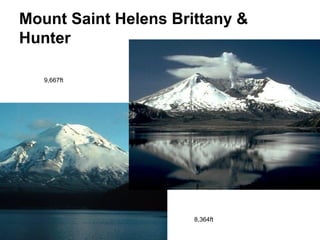
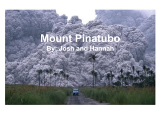
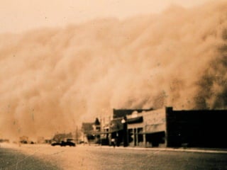
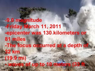
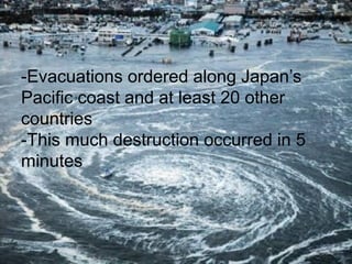
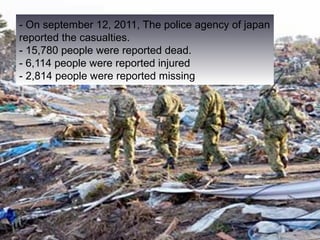
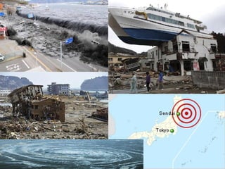
Natural and Man Made
       Disasters
        Mr. Silva’s Awesome AP
Environmental Science Class Student Work
Haiti Before The Quake


 -Palaces and slums

 ->$2/day

 -Peaceful and growing

 -hills
After The Quake
 -7.0 magnitude quake

 -3,500,000 people affected

 -Relief aid

 .5 mil homeless.

 100,000 buildings, 250,000 people
Tsunami
3 meter waves.

3 killed.

62 miles from epicenter.
Haiti, 2010: Overview
Marco, Destiny
It was a 7.0 magnitude earthquake.
Death toll at 316,000.
Strike-Slip Fault caused the earthquake
Caribbean and North American plates.
Enriquillo-Plantain Garden Fault had not moved in 200 years building up pressure.
History of Disaster
•   The island of Hispaniola which is shared by Haiti and the
    Dominican Republic is seismically active and has a
    history of destructive earthquakes.
•   Earthquakes recorded by Moreau de Saint-Méry when
    Haiti was a French Colony happened in 1751, 1770 Port-
    au-Prince.
•   Other towns in Haiti and the Dominican Republic were
    destroyed in May 1842.
•   A 8.0 earthquake was recorded on August 1946,
    producing a tsunami that killed 1,790
Damage/Strength


Magnitude 7 Earthquake
316,000 pronounced dead.
"A very big wave" hit and swept out three people to sea.
Bibliography
http://www.foreignpolicy.com/articles/2010/01/14/requiem_for_port_au_prince

http://www.dec.org.uk/haiti-earthquake-facts-and-figures

http://www.nature.com/news/2010/100225/full/news.2010.93.html

http://minnesota.publicradio.org/display/web/2011/01/11/haiti-earthquake-facts/

en.wikipedia.org/wiki/2010_Haiti_earthquake
Mt. Saint Helens
Mount Saint Helens Brittany &
 Hunter
• The mountain was
  estimated to start
  forming at around
  the early 15th
  century.
• It was generally
  formed by volcanic
  eruptions and flows
  over a long period
  of time.
                        Located in Skamania,http://www.boston.com/bigpicture/2010/05/mount_st_helens_30_years_ago.html
                                              Washington
Mount Saint Helens

  Basically the Juan de Fuca plate is
  smashing up against the North American
  Plate and is sinking below it (It being a
  oceanic plate) which is allowing magma to
  rise up.
Eruption
•   The eruption was preceded by a two-month series of
    earthquakes and steam-venting episodes.
•    An earthquake on May 18, 1980 caused the entire
    weakened north face to slide away, suddenly exposing
    the partly molten, gas- and steam-rich rock in the
    volcano to lower pressure.
•   The rock basically responded by exploding a hot mix of
    lava and pulverized rock toward Spirit Lake so quickly that it
    overtook the avalanching north face.
•   All in all... epic.
Mount Saint Helens
ount Saint Helens


                    Six feet of ash
Mount Saint Helens Brittany &
Hunter

   9,667ft


                      8,364ft
Mount Pinatubo
 By: Josh and Hannah
Before:


After:
Mount Pinatubo:
•   Took place on the Island of Luzon in the Philippines

•   A warning was sent out on June 5th, 1991 and then
    again on June 9th, 1991

•   The eruption of Mount Pinatubo began on June 15th,
    1991 at 1:42 pm

•   The eruption lasted for 9 hours
Mount Pinatubo:
•    Up to 800 people were killed and 100,000 became
    homeless

•   Tons of sulfur dioxide was discharged

•   A decrease in temp. was a result of the discharge

•   The eruption is known as the second-largest volcanic
    eruption of this century
Bibliography:
http://images.travelpod.com/tripwow/photos/ta-00e2-e19c-24bb/mount-pinatubo-philippines-
philippines+1152_12975434533-tpfil02aw-20792.jpg

http://libraryphoto.cr.usgs.gov/htmllib/btch406/btch406j/btch406z/btch406/ctj00013.jpg

http://en.wikipedia.org/wiki/File:Pinatubo_dust_layer.jpghttp://

http://en.wikipedia.org/wiki/Mount_Pinatubo

http://www.seahorsetours.com/images/pinatubocrater1.jpg

www.universetoday.com/wp-content/uploads/2010/08/Mt.-Pinatubo.jpg

http://www.guardian.co.uk/environment/2009/oct/21/geo-engineering

http://geography.about.com/od/globalproblemsandissues/a/pinatubo.htm
Dust Bowl of the 1930's
-Caused by over farming and overuse of the land.
- A giant area of land in the southern plains during the 1930's was depleted of all the nutrients in the
soil and caused giant dust storms.
- The natural grasses were killed off. Drought and winds carried the the top soil away.
Northern Texas, Oklahoma, New Mexico, Colorado, Kansas


  The sand and dust blew into the northern states
About the Dust Bowl


 -The dust bowl lasted about a decade.

 -Children went to school wearing masks and people put wet sheets over their windows attempting to
 keep the dust particles out.
Acts of the Dust Bowl

- May 1933, The Farm Mortgage Act:
$200 million dollars to help refinance
farmers
- 1934 Great Dust storms spread to
other states, covering and affecting
over 75% of the country.
- 1935, Soil Erosion Act
- 1939, Rain finally comes and ends the
drought
Farming Now

Smarter Farming:
    - Crop Rotation
    - Strip Cropping
    - Contour Plowing
Farmers were paid to practice these
techniques
Bibliography
http://www.livinghistoryfarm.org/farminginthe30s/water_02.html
http://www.pbs.org/kenburns/dustbowl/
http://www.ldeo.columbia.edu/res/div/ocp/drought/dust_storms.shtml
http://www.english.illinois.edu/maps/depression/dustbowl.htm
2011 Tohoku Earthquake and Tsunami


                     By: Matthew Koen and Mikayla Kopp
-9.0 magnitude
-Friday March 11, 2011
-epicenter was 130 kilometers or
81 miles
-The focus occurred at a depth of
32 km
(19.9 mi)
- waves of up to 10 meters (33 ft
-Evacuations ordered along Japan’s
Pacific coast and at least 20 other
countries
-This much destruction occurred in 5
minutes
- On september 12, 2011, The police agency of japan
reported the casualties.
- 15,780 people were reported dead.
- 6,114 people were reported injured
- 2,814 people were reported missing.
- Caused Nuclear accidents

- Three nuclear reactors suffered explosions
 and nuclear leakage.

- Over 200,000 people were evacuated
9.1 natural and man made disasters

9.1 natural and man made disasters