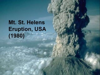
Mt. St. Helens
Eruption, USA
(1980)
Mount St. Helens is a mountain in
Skamania county, Washington state.
On May 18th, 1980, Helens had a
huge eruption that was known
worldwide. At 8:32 am, PDT, the
most economically devastating
eruption in history resulted from this
volcano spewing metric tons of
ashes. The largest landslide know to
man, ranging 600 kilometers,
stormed down the north side of the
mountain.
This volcano damaged Washington
in a very interesting way. Instead of
erupting in lava, this volcano
released huge clouds of ash. The
ash acted like sand, falling and
burying cars, houses, and people. In
total, an estimated 57 people were
killed and 250 homes, 47 bridges,
24 km of railways, and 298 km of
highway were destroyed.
Mt. St. Helens is located on the Juan de
Fuca tectonic plate. Lava built up from
almost 100 km down. As the lava built up,
it became rich with silica and gases; the
key fact to a huge explosion. The
pressure inside of Mt. St. Helens kept
growing. A 5.1magnitude earthquake
happened right below Mt. St. Helens,
causing a landslide, that took all the
weight that had been holding the magma
in the volcano, off. This caused the
volcano to explode. It erupted with the
force of a hydrogen bomb. People miles
Mount Helens was formed by a
convergent tectonic boundary plate.
The Juan de Fuca plate was (and
still is) being pushed under the North
American plate. This caused magma
to be forced up through earth’s
crust, forming Mt. St. Helens.
Note: That Juan de Fuca is being
pushed under the North American
plate at an average of 4 cm every
year.
Earth’s size has not changed
significantly. Old crust must be
recycled or destroyed. This “recycling”
happens at boundaries where plates
move towards each other. These
boundaries are called convergent
boundaries. When the plates collide, it
may take millions of years to have one
plate fully go below the other. This one
plate is melted into magma, and
sometimes spit out (an eruption).
Magma
Generation
the Juan de Fuca
plate
North
American
PlateMt. St. Helens
Subduction
Zone
Ocean
Magm
a
Magma Ascension Mantle
Mantle
(asthenosphere)
(Lithosphere)
During 1980, scientists did not have
a huge technical understanding of
volcanic eruptions. Weeks before
the huge eruption, there were small
earthquakes around Mt. St. Helens
because of all the pressure.
Because of this seismic activity
around the volcano, scientists
predicted it would erupt.
Mt Helens looked like a perfect cinder cone before it
erupted. After it erupted, it looked like a cone with the
top cut clean off. There is now a small dome that
formed in the center of the volcano.
Before the eruption, Mt. St. Helens was a
stratovalcano. After the eruption, Mt. St. Helens
became lava dome volcano. When talking about the
type of volcano, ignore the outer part of Mt. St.
Helens, because it is not part of the actual volcano
anymore. lava domes are formed by lava piling up
around the vent. Think of a lava dome as the small
dome of the volcano that is still active, of a once
bigger one. Mt. St. Helens dome grew until 1986.
These domes never erupt explosively, and the Mt. St.
Helens dome won’t erupt at all again, for a very long
As you can see, the whole north side of the mountain blew up.
Mt. St. Helens eruption created multiple
kinds of rocks. Extrusive igneous rock
was formed underground from the
magma, and intrusive igneous rock was
formed above ground, because of the
dried lava.
Some igneous rock turned into
metamorphic rock, with the heat from the
lava and pressure of the ash.
Sedimentary rock was formed from all the
small rock bits that flew out of the volcano
Earth’s crust is constantly moving,
colliding, and changing. The Juan
de Fuca moves about 4
centimeters under the North
American plate every year. The
movement and slow collision of
these two plates formed Mt. St.
Helens!
When Mt. St. Helens erupted, it
moved rocks hundreds of miles from
the volcano. That is a form of
erosion. Erratic boulders were found
in unnatural places all around Mt. St.
Helens, because of the blast.
The ash that roared out of Mt. St.
Helens made many fossils out of
plants, animals, and humans.
Humans that did not get to evacuate
were covered and suffocated in ash.
Nearby plants and animals were
also compressed in ash.
For more on the Mt. St. Helens
eruption, please watch a Special
news Report that was aired in 1980;
News Report:
http://www.youtube.com/watch?v=BA
X6N0SLCoI
The part you have been waiting for!
"Mount St. Helens." Wikipedia. Wikimedia Foundation, 27 May
2013. Web. 28 May 2013.
<http://en.wikipedia.org/wiki/Mount_St._Helens>.
Our Science Text book- “Science Probe.” Nelson. Toronto, Ontario,
2005.
Nelson Education - Home Page." Nelson Education - Home Page.
N.p., n.d. Web. 28 May 2013. <http://www.nelson.com/>.
"Day 24: Mt. St. Helens." Home. N.p., n.d. Web. 30 May 2013.
http://brianabbott.net/travels/my-american-tour/pacific-coast-
states/day-24-mt-st-helens.
"Hudson Valley Geologist." Mount St Helens ~. N.p., n.d. Web. 30
May 2013.
<http://hudsonvalleygeologist.blogspot.ca/2011/05/mount-st-
helens.html>.

Mt.hellen

  • 1.
  • 2.
    Mount St. Helensis a mountain in Skamania county, Washington state. On May 18th, 1980, Helens had a huge eruption that was known worldwide. At 8:32 am, PDT, the most economically devastating eruption in history resulted from this volcano spewing metric tons of ashes. The largest landslide know to man, ranging 600 kilometers, stormed down the north side of the mountain.
  • 3.
    This volcano damagedWashington in a very interesting way. Instead of erupting in lava, this volcano released huge clouds of ash. The ash acted like sand, falling and burying cars, houses, and people. In total, an estimated 57 people were killed and 250 homes, 47 bridges, 24 km of railways, and 298 km of highway were destroyed.
  • 4.
    Mt. St. Helensis located on the Juan de Fuca tectonic plate. Lava built up from almost 100 km down. As the lava built up, it became rich with silica and gases; the key fact to a huge explosion. The pressure inside of Mt. St. Helens kept growing. A 5.1magnitude earthquake happened right below Mt. St. Helens, causing a landslide, that took all the weight that had been holding the magma in the volcano, off. This caused the volcano to explode. It erupted with the force of a hydrogen bomb. People miles
  • 5.
    Mount Helens wasformed by a convergent tectonic boundary plate. The Juan de Fuca plate was (and still is) being pushed under the North American plate. This caused magma to be forced up through earth’s crust, forming Mt. St. Helens. Note: That Juan de Fuca is being pushed under the North American plate at an average of 4 cm every year.
  • 6.
    Earth’s size hasnot changed significantly. Old crust must be recycled or destroyed. This “recycling” happens at boundaries where plates move towards each other. These boundaries are called convergent boundaries. When the plates collide, it may take millions of years to have one plate fully go below the other. This one plate is melted into magma, and sometimes spit out (an eruption).
  • 8.
    Magma Generation the Juan deFuca plate North American PlateMt. St. Helens Subduction Zone Ocean Magm a Magma Ascension Mantle Mantle (asthenosphere) (Lithosphere)
  • 9.
    During 1980, scientistsdid not have a huge technical understanding of volcanic eruptions. Weeks before the huge eruption, there were small earthquakes around Mt. St. Helens because of all the pressure. Because of this seismic activity around the volcano, scientists predicted it would erupt.
  • 10.
    Mt Helens lookedlike a perfect cinder cone before it erupted. After it erupted, it looked like a cone with the top cut clean off. There is now a small dome that formed in the center of the volcano. Before the eruption, Mt. St. Helens was a stratovalcano. After the eruption, Mt. St. Helens became lava dome volcano. When talking about the type of volcano, ignore the outer part of Mt. St. Helens, because it is not part of the actual volcano anymore. lava domes are formed by lava piling up around the vent. Think of a lava dome as the small dome of the volcano that is still active, of a once bigger one. Mt. St. Helens dome grew until 1986. These domes never erupt explosively, and the Mt. St. Helens dome won’t erupt at all again, for a very long
  • 12.
    As you cansee, the whole north side of the mountain blew up.
  • 14.
    Mt. St. Helenseruption created multiple kinds of rocks. Extrusive igneous rock was formed underground from the magma, and intrusive igneous rock was formed above ground, because of the dried lava. Some igneous rock turned into metamorphic rock, with the heat from the lava and pressure of the ash. Sedimentary rock was formed from all the small rock bits that flew out of the volcano
  • 15.
    Earth’s crust isconstantly moving, colliding, and changing. The Juan de Fuca moves about 4 centimeters under the North American plate every year. The movement and slow collision of these two plates formed Mt. St. Helens!
  • 16.
    When Mt. St.Helens erupted, it moved rocks hundreds of miles from the volcano. That is a form of erosion. Erratic boulders were found in unnatural places all around Mt. St. Helens, because of the blast.
  • 17.
    The ash thatroared out of Mt. St. Helens made many fossils out of plants, animals, and humans. Humans that did not get to evacuate were covered and suffocated in ash. Nearby plants and animals were also compressed in ash.
  • 22.
    For more onthe Mt. St. Helens eruption, please watch a Special news Report that was aired in 1980; News Report: http://www.youtube.com/watch?v=BA X6N0SLCoI
  • 23.
    The part youhave been waiting for! "Mount St. Helens." Wikipedia. Wikimedia Foundation, 27 May 2013. Web. 28 May 2013. <http://en.wikipedia.org/wiki/Mount_St._Helens>. Our Science Text book- “Science Probe.” Nelson. Toronto, Ontario, 2005. Nelson Education - Home Page." Nelson Education - Home Page. N.p., n.d. Web. 28 May 2013. <http://www.nelson.com/>. "Day 24: Mt. St. Helens." Home. N.p., n.d. Web. 30 May 2013. http://brianabbott.net/travels/my-american-tour/pacific-coast- states/day-24-mt-st-helens. "Hudson Valley Geologist." Mount St Helens ~. N.p., n.d. Web. 30 May 2013. <http://hudsonvalleygeologist.blogspot.ca/2011/05/mount-st- helens.html>.