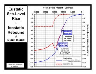
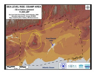
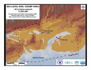
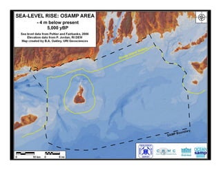
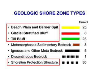
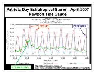
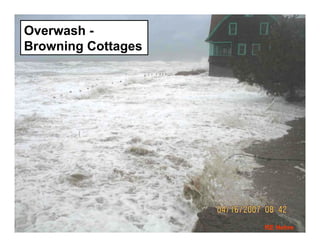
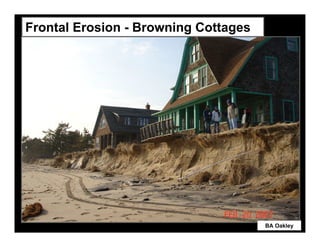
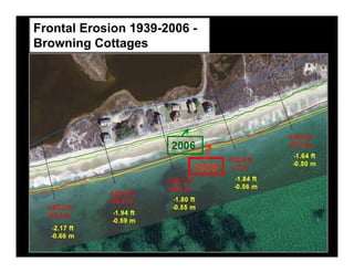
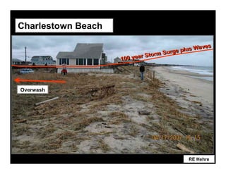
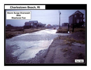
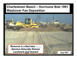
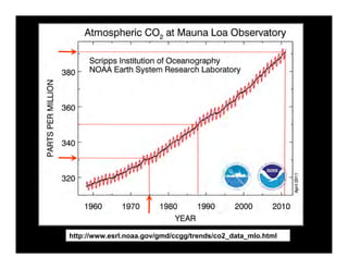
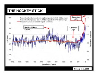
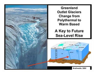
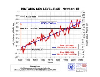
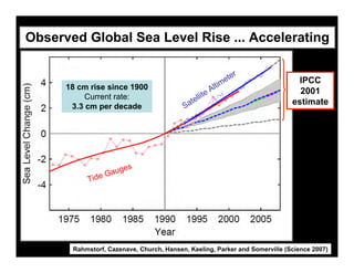
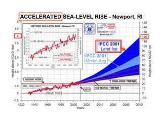
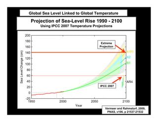
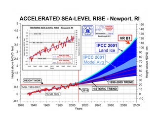
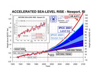
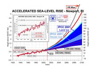
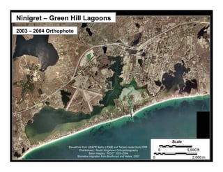
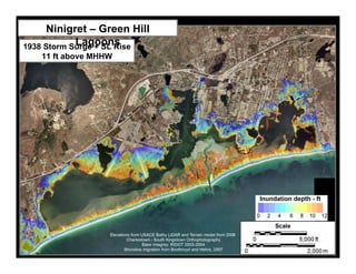
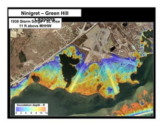
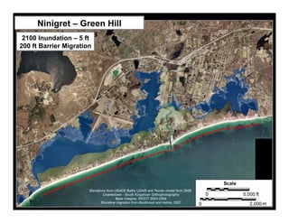
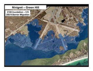
CLIMATE CHANGE, SEA-LEVEL RISE
             and
  COASTAL GEOLOGIC HAZARDS
         URI Climate Change Symposium
                        5 May 2011
                     Jon C. Boothroyd
               Rhode Island State Geologist,
     Research Professor Emeritus – Quaternary Geology
                            -------------
Rhode Island Geological Survey and Department of Geosciences
         College of the Environment and Life Sciences
                  University of Rhode Island
                     jon_boothroyd@uri.edu
Laurentide Ice Flow Directions
                     You are
                      here


-


                                     Stone and Sirkin, 1996
Map Generated By:
BA Oakley and JC Boothroyd
Oakley, 2011


         Charlestown
           Moraine


                       Ice margins modified from:
                       Dyke and Prest, 1987
                       Ridge, 2010; Goss, 1993
                       Smith, 2010
Oakley, 2011


               Ice margins modified from:
               Dyke and Prest, 1987
               Ridge, 2010; Goss, 1993
               Smith, 2010
Granitic Till Upland                  QUATERNARY
                                      DEPOSITS OF
                                     RHODE ISLAND


                          Thick Stratified Deposits

                   Narragansett structural basin

                                     Compact Till Upland


                                                         EXPLANATION
                                                         Stratified Material
                                                         Till
                                                         End Moraine - Till and
                       You are here                           Stratified Material

                                                                 Miles


                                                 0           5           10         15
               Block Island                                   Kilometers


                Complex                      0       5     10            20              30
Braided River on a Delta Plain


       A GLACIAL
      DEPOSITIONAL
-
      ENVIRONMENT
Facies Deposited in a
    Glacial Lake Depositional Environment


     Imbricated Gravel
      Facies deposited
       on a delta plain


      Stratified Coarse-
      Stratified Coarse-
-
     Medium Sand Facies
     Medium Sand Facies
     deposited on a delta
     deposited on a delta
             slope
             slope
Eustatic
Sea-Level
  Rise
    +
Isostatic
Rebound                      Laurentide
     at                      Ice Sheet?
                              Laurentide
                             2m.100yr-1
                               Ice Sheet?
Block Island                   2m.100yr-1


                            Antarctic
                        Antarctic Ice
                           Ice Sheet?
                           Sheet?
                          2-5m.100yr-1
                        2-5m.100yr-1

                              Explanation


Oakley and Boothroyd,
    in prep 2011
Post-Glacial
       Lake


Atlantic Ocean
Post-Glacial
                Lake


                            Estuary


Atlantic Ocean
- 4 m below present
     5,000 yBP
The Sea May Be Rising – But…..
Narragansett Pier Seawall –
Patriots Day 2007


                              WPRI.com
                              16 apr 2007
GEOLOGIC SHORE ZONE TYPES
                                      Percent

• Beach Plain and Barrier Spit          25
• Glacial Stratified Bluff                8
• Till Bluff                            23
• Metamorphosed Sedimentary Bedrock       8
• Igneous and Other Meta Bedrock          5
• Discontinuous Bedrock                   1
• Shoreline Protection Structure        30
Southeast
              Wind


Northeast
  Wind


                        From Wright and Sullivan, 1982
Patriots Day Extratropical Storm – April 2007
            Newport Tide Gauge

                     SET UP                              PREDICTED


                 http://tidesandcurrents.noaa.gov/
   STORM SURGE   data_menu.shtml?stn=8452660%20Newport,%20RI&type=Tide+Data
Overwash -
Browning Cottages


                    RE Hehre
Frontal Erosion - Browning Cottages


                                      BA Oakley
Frontal Erosion 1939-2006 -
Browning Cottages


                      2006

                          1939
Really Big Storms
Tidal
   Datums
   Newport


                               HEIGHT NOW
                                 New MSL
                               Old “MSL”


        Adapted from:
www.ngs.noaa.gov/newsys-cgi-
bin/ngs_opsd.prl?PID=LW0493&
      EPOCH=1983-2001
How High
 will the
Water Be?                          Boothroyd and
                                    Hehre 2008


            9.46 Feet Above MHHW


  Tidal
 Heights
 Newport


                                Adapted from: www.ngs.noaa.gov/newsys-cgi-
                              bin/ngs_opsd.prl?PID=LW0493&EPOCH=1983-2001
Frequency…?
Next Month….
  Next Year


               Adapted from
                  NOAA;
               USACE 1988;
                Hehre 2007
Charlestown Beach

                                                ves
                                     rge plus Wa
                           rS torm Su
                    100 yea


Overwash


                                           RE Hehre
Charlestown Beach, RI
Storm Surge Overwash
        With
    Washover Fan


                          Feb 1985
Charlestown Beach – Hurricane Bob 1991
Washover Fan Deposition


  Removal is a Bad Idea …….
   Barriers Naturally Retreat
    Landward and Upward          Aug 1991
Lastly,
 Climate Change
     and the
Future Shore Zone
        of
  Rhode Island
http://www.esrl.noaa.gov/gmd/ccgg/trends/co2_data_mlo.html
THE HOCKEY STICK
                          Temp lags
                            CO2


       Medieval Warm   Little Ice
       Period             Age


                             Moberg et al, 2005
Greenland
 Outlet Glaciers
  Change from
 Polythermal to
  Warm Based

A Key to Future
Sea-Level Rise


          Brathwaite, 2002
HEIGHT NOW


                       Adapted from:
        http://tidesandcurrents.noaa.gov/sltrends/
sltrends_station.shtml?stnid=8452660%20Newport,%20RI
                                                       Boothroyd 2011
Observed Global Sea Level Rise ... Accelerating

                                                                 ter
                                                           i   me             IPCC
      18 cm rise since 1900
                                                     e Alt                     2001
           Current rate:                         llit
       3.3 cm per decade                  Sate                               estimate


                    es
                Gaug
           Tide


       Rahmstorf, Cazenave, Church, Hansen, Keeling, Parker and Somerville (Science 2007)
Global Sea Level Linked to Global Temperature

Projection of Sea-Level Rise 1990 - 2100
     Using IPCC 2007 Temperature Projections


                                      Extreme
                                     Projection


                                     IPCC 2007


                                         Vermeer and Rahmstorf, 2009,
                                          PNAS, v106, p 21537-21532
VR B1
VR A1F1
VR Max
Ninigret – Green Hill Lagoons
2003 – 2004 Orthophoto
Ninigret – Green Hill
            Lagoons
1938 Storm Surge + SL Rise
   11 ft above MHHW
Ninigret – Green Hill
            Lagoons
1938 Storm Surge + SL Rise
   11 ft above MHHW
Ninigret – Green Hill Lagoons
2003 – 2004 Orthophoto
Ninigret – Green Hill
            Lagoons
2100 Inundation – 5 ft
200 ft Barrier Migration
Ninigret – Green Hill
            Lagoons
2100 Inundation – 5 ft
200 ft Barrier Migration
Coastal Rhode Island –
A Common View of the Future


                                Don
                              Bousquet,
                              June 2008

CLIMATE CHANGE, SEA-LEVEL RISE and COASTAL GEOLOGIC HAZARDS

  • 1.
    CLIMATE CHANGE, SEA-LEVELRISE and COASTAL GEOLOGIC HAZARDS URI Climate Change Symposium 5 May 2011 Jon C. Boothroyd Rhode Island State Geologist, Research Professor Emeritus – Quaternary Geology ------------- Rhode Island Geological Survey and Department of Geosciences College of the Environment and Life Sciences University of Rhode Island jon_boothroyd@uri.edu
  • 2.
    Laurentide Ice FlowDirections You are here - Stone and Sirkin, 1996
  • 3.
    Map Generated By: BAOakley and JC Boothroyd
  • 4.
    Oakley, 2011 Charlestown Moraine Ice margins modified from: Dyke and Prest, 1987 Ridge, 2010; Goss, 1993 Smith, 2010
  • 5.
    Oakley, 2011 Ice margins modified from: Dyke and Prest, 1987 Ridge, 2010; Goss, 1993 Smith, 2010
  • 6.
    Granitic Till Upland QUATERNARY DEPOSITS OF RHODE ISLAND Thick Stratified Deposits Narragansett structural basin Compact Till Upland EXPLANATION Stratified Material Till End Moraine - Till and You are here Stratified Material Miles 0 5 10 15 Block Island Kilometers Complex 0 5 10 20 30
  • 7.
    Braided River ona Delta Plain A GLACIAL DEPOSITIONAL - ENVIRONMENT
  • 8.
    Facies Deposited ina Glacial Lake Depositional Environment Imbricated Gravel Facies deposited on a delta plain Stratified Coarse- Stratified Coarse- - Medium Sand Facies Medium Sand Facies deposited on a delta deposited on a delta slope slope
  • 9.
    Eustatic Sea-Level Rise + Isostatic Rebound Laurentide at Ice Sheet? Laurentide 2m.100yr-1 Ice Sheet? Block Island 2m.100yr-1 Antarctic Antarctic Ice Ice Sheet? Sheet? 2-5m.100yr-1 2-5m.100yr-1 Explanation Oakley and Boothroyd, in prep 2011
  • 10.
    Post-Glacial Lake Atlantic Ocean
  • 11.
    Post-Glacial Lake Estuary Atlantic Ocean
  • 12.
    - 4 mbelow present 5,000 yBP
  • 13.
    The Sea MayBe Rising – But….. Narragansett Pier Seawall – Patriots Day 2007 WPRI.com 16 apr 2007
  • 15.
    GEOLOGIC SHORE ZONETYPES Percent • Beach Plain and Barrier Spit 25 • Glacial Stratified Bluff 8 • Till Bluff 23 • Metamorphosed Sedimentary Bedrock 8 • Igneous and Other Meta Bedrock 5 • Discontinuous Bedrock 1 • Shoreline Protection Structure 30
  • 16.
    Southeast Wind Northeast Wind From Wright and Sullivan, 1982
  • 17.
    Patriots Day ExtratropicalStorm – April 2007 Newport Tide Gauge SET UP PREDICTED http://tidesandcurrents.noaa.gov/ STORM SURGE data_menu.shtml?stn=8452660%20Newport,%20RI&type=Tide+Data
  • 18.
  • 19.
    Frontal Erosion -Browning Cottages BA Oakley
  • 20.
    Frontal Erosion 1939-2006- Browning Cottages 2006 1939
  • 21.
  • 22.
    Tidal Datums Newport HEIGHT NOW New MSL Old “MSL” Adapted from: www.ngs.noaa.gov/newsys-cgi- bin/ngs_opsd.prl?PID=LW0493& EPOCH=1983-2001
  • 23.
    How High willthe Water Be? Boothroyd and Hehre 2008 9.46 Feet Above MHHW Tidal Heights Newport Adapted from: www.ngs.noaa.gov/newsys-cgi- bin/ngs_opsd.prl?PID=LW0493&EPOCH=1983-2001
  • 24.
    Frequency…? Next Month…. Next Year Adapted from NOAA; USACE 1988; Hehre 2007
  • 25.
    Charlestown Beach ves rge plus Wa rS torm Su 100 yea Overwash RE Hehre
  • 26.
    Charlestown Beach, RI StormSurge Overwash With Washover Fan Feb 1985
  • 27.
    Charlestown Beach –Hurricane Bob 1991 Washover Fan Deposition Removal is a Bad Idea ……. Barriers Naturally Retreat Landward and Upward Aug 1991
  • 28.
    Lastly, Climate Change and the Future Shore Zone of Rhode Island
  • 29.
  • 30.
    THE HOCKEY STICK Temp lags CO2 Medieval Warm Little Ice Period Age Moberg et al, 2005
  • 31.
    Greenland Outlet Glaciers Change from Polythermal to Warm Based A Key to Future Sea-Level Rise Brathwaite, 2002
  • 32.
    HEIGHT NOW Adapted from: http://tidesandcurrents.noaa.gov/sltrends/ sltrends_station.shtml?stnid=8452660%20Newport,%20RI Boothroyd 2011
  • 33.
    Observed Global SeaLevel Rise ... Accelerating ter i me IPCC 18 cm rise since 1900 e Alt 2001 Current rate: llit 3.3 cm per decade Sate estimate es Gaug Tide Rahmstorf, Cazenave, Church, Hansen, Keeling, Parker and Somerville (Science 2007)
  • 35.
    Global Sea LevelLinked to Global Temperature Projection of Sea-Level Rise 1990 - 2100 Using IPCC 2007 Temperature Projections Extreme Projection IPCC 2007 Vermeer and Rahmstorf, 2009, PNAS, v106, p 21537-21532
  • 36.
  • 37.
  • 38.
  • 39.
    Ninigret – GreenHill Lagoons 2003 – 2004 Orthophoto
  • 40.
    Ninigret – GreenHill Lagoons 1938 Storm Surge + SL Rise 11 ft above MHHW
  • 41.
    Ninigret – GreenHill Lagoons 1938 Storm Surge + SL Rise 11 ft above MHHW
  • 42.
    Ninigret – GreenHill Lagoons 2003 – 2004 Orthophoto
  • 43.
    Ninigret – GreenHill Lagoons 2100 Inundation – 5 ft 200 ft Barrier Migration
  • 44.
    Ninigret – GreenHill Lagoons 2100 Inundation – 5 ft 200 ft Barrier Migration
  • 45.
    Coastal Rhode Island– A Common View of the Future Don Bousquet, June 2008