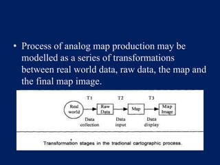
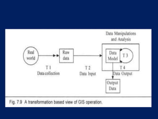
THEORETICAL
FRAMEWORK FOR GIS
www.justbtech.com
GIS Lecture Series
What You will learn
• How data are transformed and held as a model
of real world
• Different types of transformations that data is
subjected to in
– Conventional Map Making process
– GIS
• Example explaining theoretical framework and
transformations in GIS
• Present discussion of theoretical framework is
not related to any specific software,
• But it is a model of how different processes
take place in a digital GIS environment while
producing the digital geographic(spatial)
information.
• The data representation here in this discussion
should not be confused with any specific type
of data structure such as raster, vector, TIN,
attribute etc.
• All (many) of the information systems have
the capability to apply principal
transformations on the data to some extent for
converting it into information.
• But, only those software which have some
capacity for input, manipulate and output the
digital spatial data in some format are
considered as GIS.
• The GIS approach of transforming data into
information is based on the cartographic
principles.
• Cartography (cartographers) provide the
understanding of relationships between the real
world and map as a model.
• The relationships helps in understanding
various transformations the real world data
takes to become a map.
• Process of analog map production may be
modelled as a series of transformations
between real world data, raw data, the map and
the final map image.
• The significance of these transformations is
that they control the amount of information
transmitted from one stage to the next.
• The cartographer's task is to devise the very
best approximation to an 'ideal' transformation
involving a minimum of information loss.
• In GIS, the approach is extended to convert the
paper map into a digital map (digital
information).
• In GIS, the approach is extended to convert the
paper map into a digital map (digital
information).
• In the context of GIS, an additional
transformation stage which sits entirely within
the GIS is added.
• In the first transformation (T1 ), data are selected
from the real word, as for example, surveying
measurements or census data.
• These are then input for the GIS in some form
(T2) to provide the basis for its digital map
representation of the real world.
• Within the system, a vast range of manipulation
operations are available to further transform the
data and store the results (T 3), and these may be
communicated as tabulated or graphic images by
means of a hardcopy or screen (T4).
• Each of these transformation stages may actually
involve several physical operations on the data.
• T1 may involve both collection and aggregation,
and T 3 will almost always consist of a whole
series of data-processing operations.
• If the 'thematic and spatial' charateristics which
are very important are to be understood, it is
necessary for us to carefully consider the way in
which these four transformations may effect the
digital representation of the real-world objects
• The concept and understanding of the above
mentioned transformation forms the theoretical
frame work of GIS.
• The understanding of GIS data manipulation,
and obtaining information from real world data
using a GIS model is based on the
understanding of theoretical framework, which
forms the basis of GIS modelling the real
world.
• Thankyou.

Theoretical framework for gis

  • 1.
  • 2.
    What You willlearn • How data are transformed and held as a model of real world • Different types of transformations that data is subjected to in – Conventional Map Making process – GIS • Example explaining theoretical framework and transformations in GIS
  • 3.
    • Present discussionof theoretical framework is not related to any specific software, • But it is a model of how different processes take place in a digital GIS environment while producing the digital geographic(spatial) information.
  • 4.
    • The datarepresentation here in this discussion should not be confused with any specific type of data structure such as raster, vector, TIN, attribute etc.
  • 5.
    • All (many)of the information systems have the capability to apply principal transformations on the data to some extent for converting it into information. • But, only those software which have some capacity for input, manipulate and output the digital spatial data in some format are considered as GIS.
  • 6.
    • The GISapproach of transforming data into information is based on the cartographic principles. • Cartography (cartographers) provide the understanding of relationships between the real world and map as a model. • The relationships helps in understanding various transformations the real world data takes to become a map.
  • 7.
    • Process ofanalog map production may be modelled as a series of transformations between real world data, raw data, the map and the final map image.
  • 8.
    • The significanceof these transformations is that they control the amount of information transmitted from one stage to the next. • The cartographer's task is to devise the very best approximation to an 'ideal' transformation involving a minimum of information loss. • In GIS, the approach is extended to convert the paper map into a digital map (digital information).
  • 9.
    • In GIS,the approach is extended to convert the paper map into a digital map (digital information). • In the context of GIS, an additional transformation stage which sits entirely within the GIS is added.
  • 10.
    • In thefirst transformation (T1 ), data are selected from the real word, as for example, surveying measurements or census data. • These are then input for the GIS in some form (T2) to provide the basis for its digital map representation of the real world. • Within the system, a vast range of manipulation operations are available to further transform the data and store the results (T 3), and these may be communicated as tabulated or graphic images by means of a hardcopy or screen (T4).
  • 12.
    • Each ofthese transformation stages may actually involve several physical operations on the data. • T1 may involve both collection and aggregation, and T 3 will almost always consist of a whole series of data-processing operations. • If the 'thematic and spatial' charateristics which are very important are to be understood, it is necessary for us to carefully consider the way in which these four transformations may effect the digital representation of the real-world objects
  • 13.
    • The conceptand understanding of the above mentioned transformation forms the theoretical frame work of GIS. • The understanding of GIS data manipulation, and obtaining information from real world data using a GIS model is based on the understanding of theoretical framework, which forms the basis of GIS modelling the real world.
  • 14.