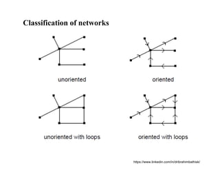
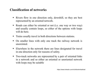
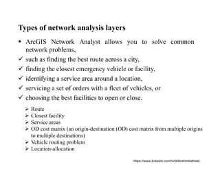
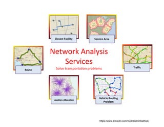
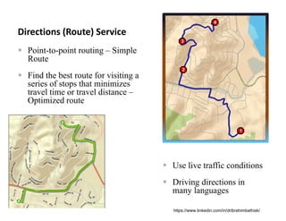
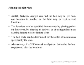
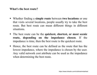
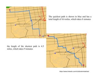
A network is a system of interconnected elements, such as edges (lines) and connecting junctions (points), that represent possible routes from one location to another.
Here I explained introduction to the network analysis in GIS.
2. GEOGRAPHIC INFORMATION SYSTEM (GIS)
A geographic information system (GIS) is a digital computer
application designed for the capture, storage, manipulation,
analysis and display of geographic information.
Geographic location is the element that distinguishes
geographic information from all other types of information.
Without location, data are termed to be non-spatial and would
have little value within a GIS.
Location is, thus, the basis for many benefits of GIS: the
ability to map, the ability to measure distances and the ability
to tie different kinds of information together because they refer
to the same place
https://www.linkedin.com/in/dribrahimbathisk/
4. What is NETWORK?
A network is a system of interconnected elements, such as
edges (lines) and connecting junctions (points), that represent
possible routes from one location to another.
Edges or Links
Junctions
Or Nodes
https://www.linkedin.com/in/dribrahimbathisk/
5. What is NETWORK?
In general, a network is a system of interconnected linear
features through which resources are transported or
communication is achieved.
The network data model is an abstract representation of the
components and characteristics of real-world network systems.
One major application of network analysis is found in
transportation planning, where the issue might be to find paths
corresponding to certain criteria, like finding the shortest or
least cost path between two or more locations, or to find all
locations within a given travel cost from a specified origin.
https://www.linkedin.com/in/dribrahimbathisk/
6. What is NETWORK?
Network Analysis in GIS is based on the mathematical sub-
disciplines of graph theory and topology.
Topological properties of networks are:
connectivity, adjacency, and incidence.
These properties serve as a basis for analysis.
A simple example of a network in GIS can be streets, power
lines, or city centerlines.
https://www.linkedin.com/in/dribrahimbathisk/
7. What is NETWORK?
People, resources, and goods tend to travel along networks:
cars and trucks travel on roads, airliners fly on predetermined
flight paths, oil flows in pipelines.
Information networks
Social networks
Stream networks
Transportation networks
By modeling potential travel paths with a network, it is
possible to perform analyses related to the movement of the
oil, trucks, or other agents on the network.
https://www.linkedin.com/in/dribrahimbathisk/
15. Classification of networks
Rivers flow in one direction only, downhill, so they are best
represented by an oriented network.
Roads can either be oriented or not (i.e. one way or two way)
and usually contain loops, so either of the options with loops
will do here.
Trains usually travel in both directions between stations.
On smaller lines with only one track the railway network is
unoreinted.
Elsewhere in the network there are lines designated for travel
in one direction only for reasons of safety.
Two-track networks are represented by a pair of oriented links
in a network and so either an oriented or unoriented network
with loops may be suitable
https://www.linkedin.com/in/dribrahimbathisk/
16. Types of network analysis layers
ArcGIS Network Analyst allows you to solve common
network problems,
such as finding the best route across a city,
finding the closest emergency vehicle or facility,
identifying a service area around a location,
servicing a set of orders with a fleet of vehicles, or
choosing the best facilities to open or close.
Route
Closest facility
Service areas
OD cost matrix (an origin-destination (OD) cost matrix from multiple origins
to multiple destinations)
Vehicle routing problem
Location-allocation
https://www.linkedin.com/in/dribrahimbathisk/
18. Directions (Route) Service
Point-to-point routing – Simple
Route
Find the best route for visiting a
series of stops that minimizes
travel time or travel distance –
Optimized route
Use live traffic conditions
Driving directions in
many languages
https://www.linkedin.com/in/dribrahimbathisk/
19. Finding the best route
ArcGIS Network Analyst can find the best way to get from
one location to another or the best way to visit several
locations.
The locations can be specified interactively by placing points
on the screen, by entering an address, or by using points in an
existing feature class or feature layer.
The best route can be determined for the order of locations as
specified by the user.
Alternatively, ArcGIS Network Analyst can determine the best
sequence to visit the locations.
https://www.linkedin.com/in/dribrahimbathisk/
20. What's the best route?
Whether finding a simple route between two locations or one
that visits several locations, people usually try to take the best
route. But best route can mean different things in different
situations.
The best route can be the quickest, shortest, or most scenic
route, depending on the impedance chosen. If the
impedance is time, then the best route is the quickest route.
Hence, the best route can be defined as the route that has the
lowest impedance, where the impedance is chosen by the user.
Any valid network cost attribute can be used as the impedance
when determining the best route.
https://www.linkedin.com/in/dribrahimbathisk/
21. The quickest path is shown in blue and has a
total length of 4.6 miles, which takes 8 minutes
the length of the shortest path is 4.5
miles, which takes 9 minutes
https://www.linkedin.com/in/dribrahimbathisk/