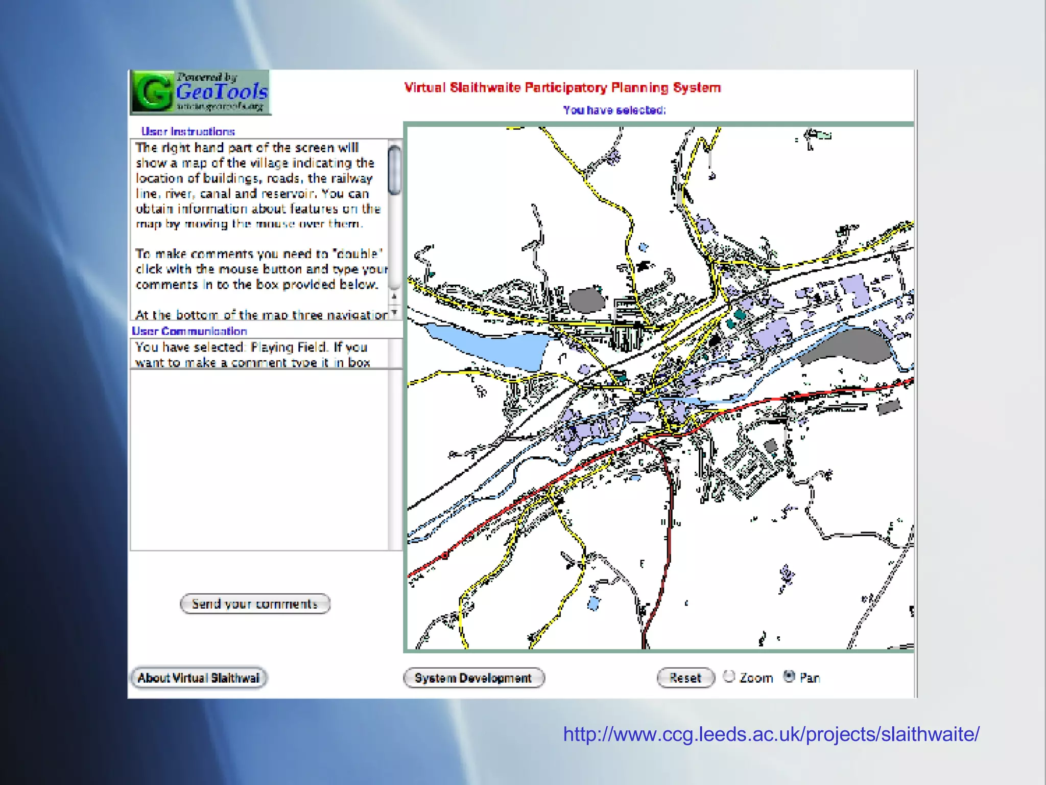
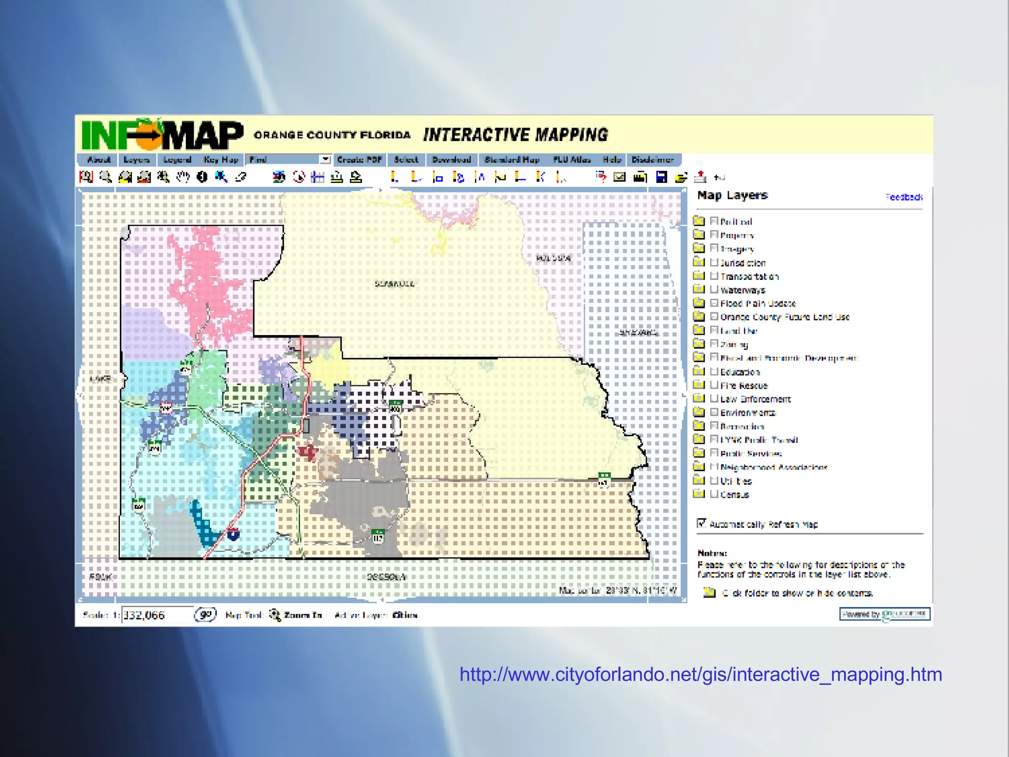
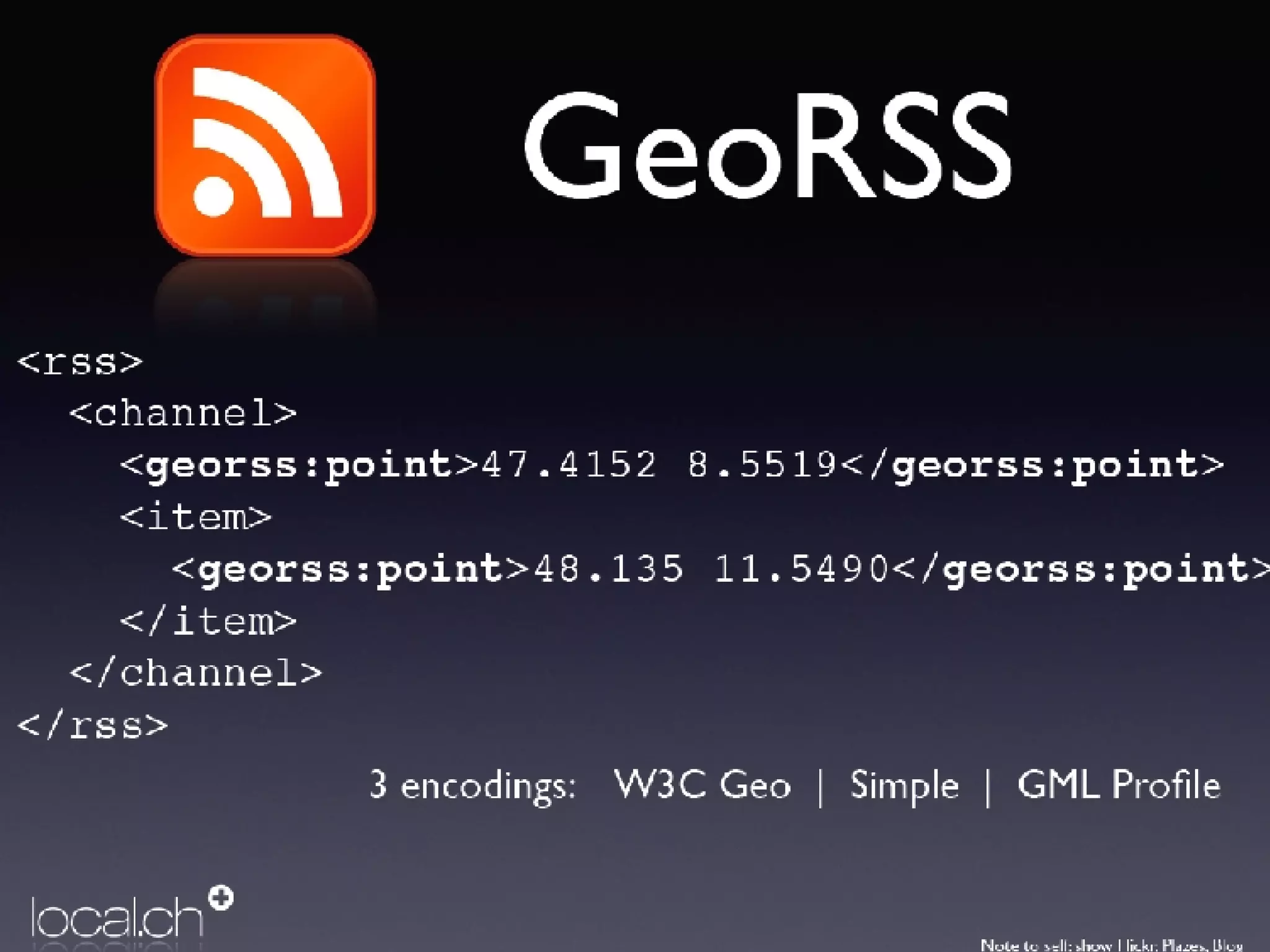
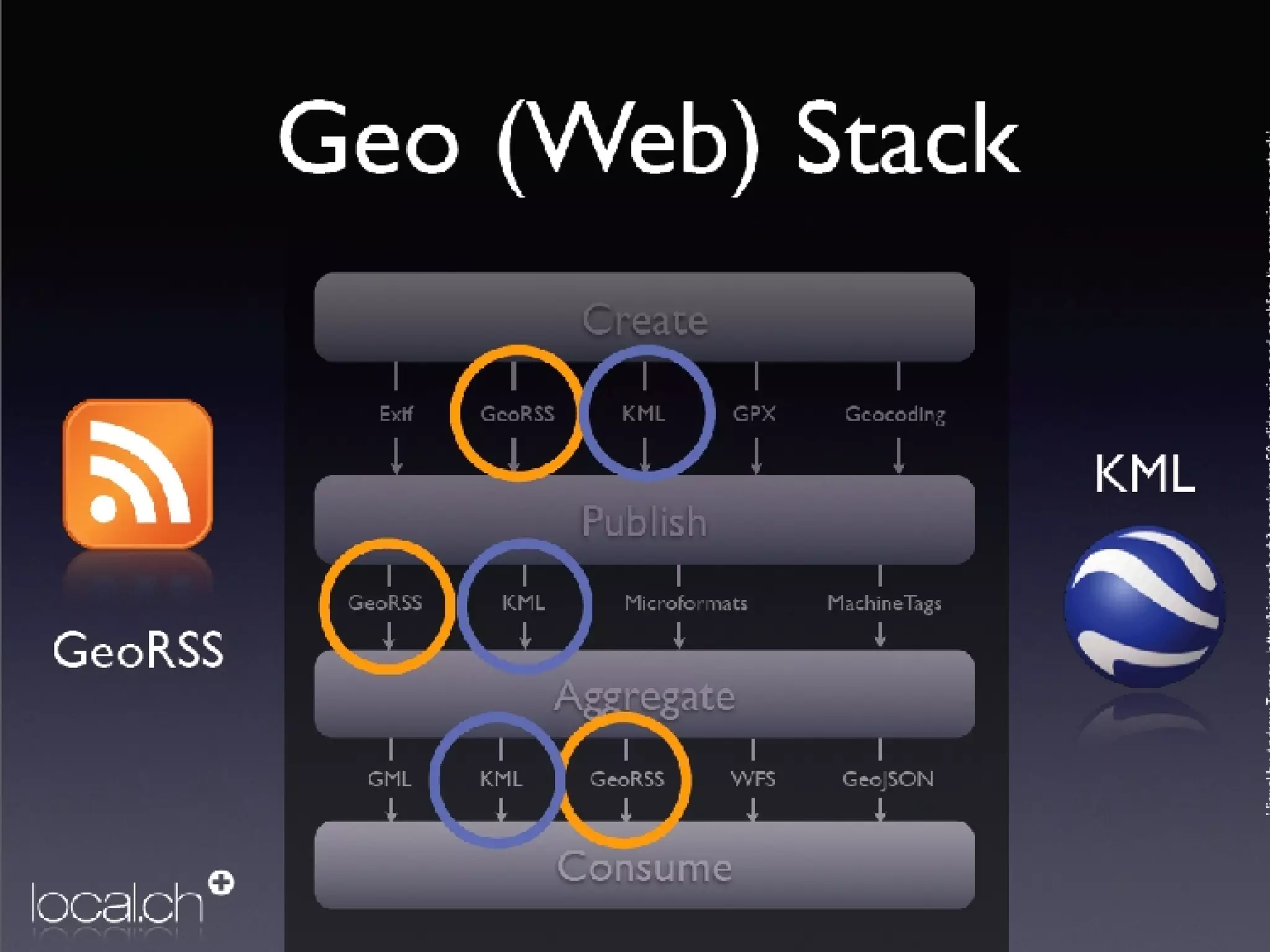
Future of Geospatial Information Use
1990’s Critics painted GIS as a positivist epistemology which has inherent limitations  Scientific knowledge as the only authentic knowledge This lead to the emergence of Critical GIS debate GIS is not Value Neutral  And does not meet the needs of marginalized populations Has significant limitations
Limitations Can not model on-the-ground processes and local dynamics GIS was largely conducted by technicians who did not necessarily possess understanding of local dynamics and local knowledge but instead acted as facilitators GIS failed to encompass other ways of knowing The non-expert mapper’s geospatial language did not match terminology inherent in the GISystem This limited its application
GIS Terminology Language we commonly know Open Project, save project May Layers Add Data Raster and Vector data Limits of storing non-spatial data in tables and databases linked to shape files
Public Participation GIS The outcome of Critical GIS movement Term derived from urban planning where community interests intersect with GIS technology This lead to increased transparency within urban planning through  bottom-up GIS The community members are no longer seen as passive actors within the planning process but active participants This lead to a more holistic approach incorporated within the planning process
Bottom-Up GIS Community members seen as role leaders and key for decision making in approaches to urban planning issues Academically researchers attempt to make their work more accessible and relevant to the community Bottom-Up approach similar to User-Centered models implemented in Website design
Role of Web-based GIS Web-based GIS was seen as a means of improving access and transparency Information was now available 24/7 and participation could be incorporated through forums and online chatting and discussion groups This was thought to democratize GIS within the professional and academic spheres
The Reality Web-GIS is subject to nearly all the same critiques highlighted in traditional GIS Web-GIS developed and controlled by the major stakeholders ie. The city or the university Data acquisition is expensive and can sometimes involve interpersonal contingencies and power relationships ie the city official calls in a favor with MNR but MNR requests certain caveats Responsibility for development, maintenance, usage, and financial solvency is dispersed through a network of overlapping actors which can increase cost to maintain
Reality in the 90’s  Web-GIS projects add complexity to traditional community-based GIS by increasing development costs, widening the client base, and heightening public visibility. They also consider only those individuals who are computer literate and have access to computer resources
http://www.ccg.leeds.ac.uk/projects/slaithwaite/
http://www.evl.uic.edu/sopark/new/RA/#sub1
http://www.cityoforlando.net/gis/interactive_mapping.htm
States of Citizen Engagement  Web GIS were isolated information silos  Interaction was primarily one way. Users could view data and input information that would be stored on a local server Spatial data could be accessed Maps could be created and printed out Users could add their own data
Current Generation Web-GIS Users can do the same as before but more. Users can Upload and Download Data no longer is stored on the local server Issues of ownership has changed Users can generate and distribute their own content.  This causes a rise in the economic value of the web as users can do more.
What Changed ? New forms of Geospatial Data built upon extensible markup language GeoRSS Feeds Keyhole Markup Language Invention of the KML extension as means of geospatial data sharing Shapefiles can be converted to KML KML can be read by Desktop GIS Google maps can be exported to KML
Open Source Movement GIS moved out of the basement and into the forefront of development Google maps, Google Earth, Yahoo! Maps, Virtual Earth, ArcWeb Easy mapping, Age of the amateur
 
 
Neogeography Geographical techniques and tools used for personal activities or for utilization by a non-expert group of users; not formal or analytical
It all about the user
New data formats Allows users to create data that easily integrates with richer formats of information This will create a Geoweb where geographic information is tied to abstract information - Geobrowsers People can then search for things based on location instead of only keywords eg  http://nearbynow.com/
Collaborative Mapping A diverse commons of mapping data constantly updated by citizens, governments and the private sector Data creation is following in the foot steps of Wikipedia and other social applications Open Street Map - started in 2004, amateurs (in the best sense of the word), hobbyists and 'true believers' 'The Success of Collaborative Mapping'? - a diverse commons of mapping data constantly updated by citizens, governments and the private sector
Ubiquitous Computing As phones get smarter Android (google’s new mobile platform) iPhone Geospatial information becomes more important - searching by location is more valid It also becomes easier to create Geospatial data
What Does the Future Hold? More Collaborative mapping Data that is more relevant and more refined to specific locations Greater availability of standard geospatial data for free or lower cost More innovation at the hands of amateurs which will drive industry rather than vice versa

Changing Role Of Geospatial Technology

  • 1.
    Future of GeospatialInformation Use
  • 2.
    1990’s Critics paintedGIS as a positivist epistemology which has inherent limitations Scientific knowledge as the only authentic knowledge This lead to the emergence of Critical GIS debate GIS is not Value Neutral And does not meet the needs of marginalized populations Has significant limitations
  • 3.
    Limitations Can notmodel on-the-ground processes and local dynamics GIS was largely conducted by technicians who did not necessarily possess understanding of local dynamics and local knowledge but instead acted as facilitators GIS failed to encompass other ways of knowing The non-expert mapper’s geospatial language did not match terminology inherent in the GISystem This limited its application
  • 4.
    GIS Terminology Languagewe commonly know Open Project, save project May Layers Add Data Raster and Vector data Limits of storing non-spatial data in tables and databases linked to shape files
  • 5.
    Public Participation GISThe outcome of Critical GIS movement Term derived from urban planning where community interests intersect with GIS technology This lead to increased transparency within urban planning through bottom-up GIS The community members are no longer seen as passive actors within the planning process but active participants This lead to a more holistic approach incorporated within the planning process
  • 6.
    Bottom-Up GIS Communitymembers seen as role leaders and key for decision making in approaches to urban planning issues Academically researchers attempt to make their work more accessible and relevant to the community Bottom-Up approach similar to User-Centered models implemented in Website design
  • 7.
    Role of Web-basedGIS Web-based GIS was seen as a means of improving access and transparency Information was now available 24/7 and participation could be incorporated through forums and online chatting and discussion groups This was thought to democratize GIS within the professional and academic spheres
  • 8.
    The Reality Web-GISis subject to nearly all the same critiques highlighted in traditional GIS Web-GIS developed and controlled by the major stakeholders ie. The city or the university Data acquisition is expensive and can sometimes involve interpersonal contingencies and power relationships ie the city official calls in a favor with MNR but MNR requests certain caveats Responsibility for development, maintenance, usage, and financial solvency is dispersed through a network of overlapping actors which can increase cost to maintain
  • 9.
    Reality in the90’s Web-GIS projects add complexity to traditional community-based GIS by increasing development costs, widening the client base, and heightening public visibility. They also consider only those individuals who are computer literate and have access to computer resources
  • 10.
  • 11.
  • 12.
  • 13.
    States of CitizenEngagement Web GIS were isolated information silos Interaction was primarily one way. Users could view data and input information that would be stored on a local server Spatial data could be accessed Maps could be created and printed out Users could add their own data
  • 14.
    Current Generation Web-GISUsers can do the same as before but more. Users can Upload and Download Data no longer is stored on the local server Issues of ownership has changed Users can generate and distribute their own content. This causes a rise in the economic value of the web as users can do more.
  • 15.
    What Changed ?New forms of Geospatial Data built upon extensible markup language GeoRSS Feeds Keyhole Markup Language Invention of the KML extension as means of geospatial data sharing Shapefiles can be converted to KML KML can be read by Desktop GIS Google maps can be exported to KML
  • 16.
    Open Source MovementGIS moved out of the basement and into the forefront of development Google maps, Google Earth, Yahoo! Maps, Virtual Earth, ArcWeb Easy mapping, Age of the amateur
  • 17.
  • 18.
  • 19.
    Neogeography Geographical techniquesand tools used for personal activities or for utilization by a non-expert group of users; not formal or analytical
  • 20.
    It all aboutthe user
  • 21.
    New data formatsAllows users to create data that easily integrates with richer formats of information This will create a Geoweb where geographic information is tied to abstract information - Geobrowsers People can then search for things based on location instead of only keywords eg http://nearbynow.com/
  • 22.
    Collaborative Mapping Adiverse commons of mapping data constantly updated by citizens, governments and the private sector Data creation is following in the foot steps of Wikipedia and other social applications Open Street Map - started in 2004, amateurs (in the best sense of the word), hobbyists and 'true believers' 'The Success of Collaborative Mapping'? - a diverse commons of mapping data constantly updated by citizens, governments and the private sector
  • 23.
    Ubiquitous Computing Asphones get smarter Android (google’s new mobile platform) iPhone Geospatial information becomes more important - searching by location is more valid It also becomes easier to create Geospatial data
  • 24.
    What Does theFuture Hold? More Collaborative mapping Data that is more relevant and more refined to specific locations Greater availability of standard geospatial data for free or lower cost More innovation at the hands of amateurs which will drive industry rather than vice versa