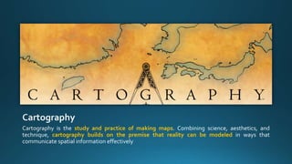
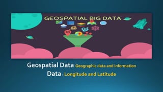
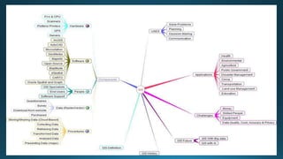
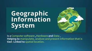
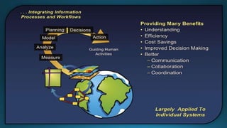
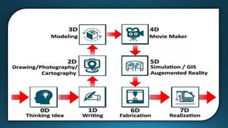
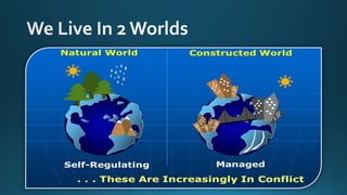
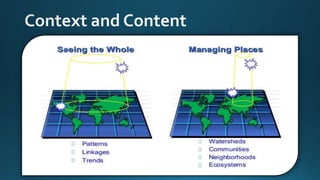
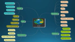
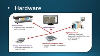
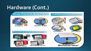
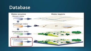
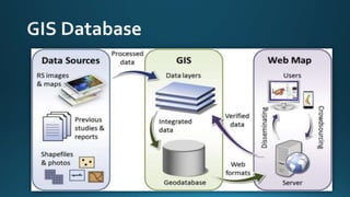
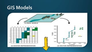
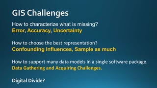
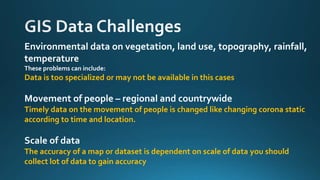
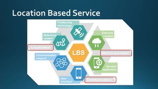
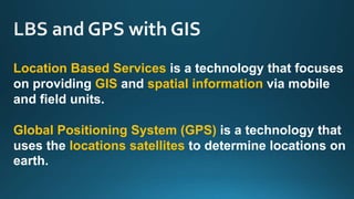
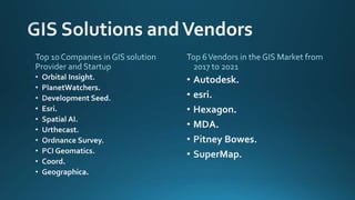
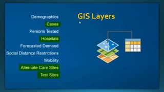
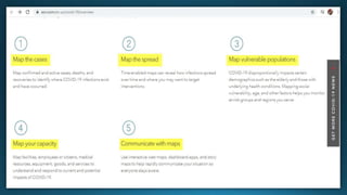
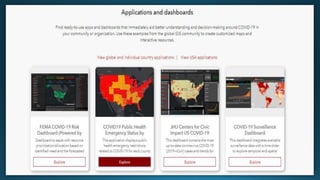
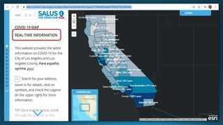
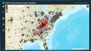
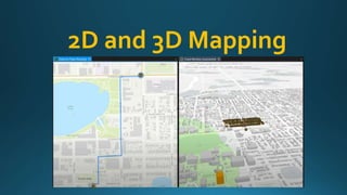
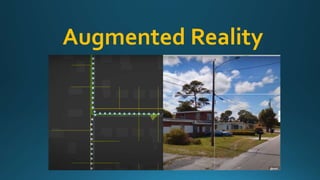
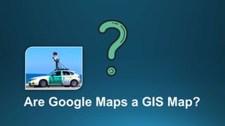
Prepared by: Ossama Mohamed ELShanawany
Under Supervision of:
Prof. Dr.Abd El-Fattah Hegazi
Agenda Style
01 What is Cartography and Geospatial Data ?
02 Mindmap
03 What is GIS ?
04 GIS History ?
05 What is the idea ?
06 Dimensions Modeling in GIS ?
07 Building information modeling (BIM) ?
08 GIS Components
09 Spatial Data
10GIS Models real word(Raster,Vector)
11GIS Process
12 GIS Benefits
13GIS Challenges ? Data andTech.
14 GIS Functionality
16 Oil and Gas Case
17 Corona virus COVID 19 Case
18 Telecommunication 5G Case
19 esri use Big Data, AI, AR, ML
15 LBS Services and GPS
Cartography is the study and practice of making maps. Combining science, aesthetics, and
technique, cartography builds on the premise that reality can be modeled in ways that
communicate spatial information effectively
Geographic data and information
Data+ Longitude and Latitude
Computer software Hardware Data .
Helping to manipulate, analyze and present information that is
tied  Linked to spatial location.
generation management
plan design construct operate maintain physical
Building information modeling
(BIM)
blending the BIM model into layers of the geospatial
construction materials orientation location
Functions and tools needed to Capture Data, Managing
Data, analyze, and display geographic information.
1. Data capture
o Import digital data from a disk, network or database
o Digitizing this Data
2. Data management
o Creation & management of metadata
o Use tool to detect errors
3. Data analysis
o Provides tools for query and retrieve data
4. Data visualization
o Present data in tabular form, over graph/chart and print maps
o Output can be stored in disk or web server, to provides dynamic views of data
• Operating System (OS) - WindowsY2K/NT
• Graphic software (CAD, Microstation)
• Database software (dBASE, Oracle)
• Statistical packages (SPSS, SAS, Minitab)
• Word processing (MsWord, Word Perfect)
• Image processing (IDRISI, ER Mapper)
• GIS systems (Arc/Info, ArcView, MapInfo)
• Presentation (Ms PowerPoint, Coral Draw)
• Collected in-house.
• Purchased from a commercial data provider.
• Integrate spatial data with other data resources
and use a DBMS.
• Spatial
Data related to location represented as POINTS, LINES,
and POLYGONS
Example Coordinate of center of football ground
• Aspatial (Non Spatial)
TABULAR DATA which records characteristics of the geographic
location
Example name of roads ,schools
Example:
A park is a spatial feature the information about the park are non-spatial
1. Location
2. Description
Arab academy, Sheraton Al Matar, El Nozha
3. Post Code A postal code is a series of letters or digits or both .
114
4. Grid reference Grid lines on maps define the coordinate system
151919.1 131518.1
5. longitude and latitude
30.0817° N, 31.0179° E
1. Coordinates Where each feature is located
2. Attributes What each feature represent
3. Topology Relationships among features
4. Geometry Physical shape of the feature
More aboutTopology and Geometry
Geometry
• A building Shape.
• county Shape.
• The course of a river.
• the route of a road.
• The landscape Shape.
Topology How Geographical data related to other
• Connected to
• Within
• Adjacent to
• North of . . .
Socio Economic Data
• Data about humans
• Educational level
• Human activities
• Age, sex, ethnic and marital status
• Housing (quality, cost)
Dangme West Poor
Environmental Data
• Topographic data
• Soils, geology
Sina Egypt
Vector Is a data structured, used to store spatial data
Points and Lines
If Draw If Draw If Draw
Uses a series of cells to represent locations on the earth
Contains levels of Raster and levelsVector
Data
Step One
Features
• Buildings
• Road centerlines
• Lamp columns
• Gas pipes
• Electrical Infrastructure
• Road surfaces
Step Two
Geometric shapes
• Point
• Lines
• Polygon
Step Three
On Map
• Feature
• Object
• Entity
Collect
Data
• Data Acquisition
• LocationWhat is at ?
• PatternsWhat spatial patterns exist ?
Data
Process
• Pre -processing Data
• Data Management
Analyze
• Processing Data
Result
• Product Generation
• Decision
• Report
How to characterize what is missing?
Error, Accuracy, Uncertainty
How to choose the best representation?
Confounding Influences, Sample as much
How to support many data models in a single software package.
Data Gathering and Acquiring Challenges.
Digital Divide?
Environmental data on vegetation, land use, topography, rainfall,
temperature
These problems can include:
Data is too specialized or may not be available in this cases
Movement of people – regional and countrywide
Timely data on the movement of people is changed like changing corona static
according to time and location.
Scale of data
The accuracy of a map or dataset is dependent on scale of data you should
collect lot of data to gain accuracy
Computer hardware
These problems can include:
Computer Resources
Operation system bugs
GIS software
The main problem with software is the cost.
Training on Who use the software
Training people to use this software and be familiars
The Functions of GIS describe the steps that have to be taken to implement a GIS
1. Data Capture.
2. Data Compilation.
3. Data Storage (GIS Data Models).
4. Manipulation.
5. Analysis.
The Functions of GIS describe the steps that have to be taken to implement a GIS
1. Data Capture.
Data used in GIS often comes from many sources
• paper maps
• existing digital data sets.
• Remote sensing satellite
• Manual Digitization
Digitization
A conversion process which converts paper maps into numerical digits that can be stored in the computer.
Digitizing simplifies map data into sets of points, lines, or cells that can be stored in the GIS computers
The Functions of GIS describe the steps that have to be taken to implement a GIS
2. Data Compilation.
The end results of compilation is a set of digital files, each
accurately representing all of the spatial location and
attribute data contained on the original map.
Spatial Location Attributedata+
The Functions of GIS describe the steps that have to be taken to implement a GIS
3. Data Storage (GIS Data Models).
Data storage is based on a Data Model that is used to
convert map data into a digital form.
Data Models Raster andVector
The Functions of GIS describe the steps that have to be taken to implement a GIS
4. Manipulation.
Most GIS software packages come with a suite of
options that allow the user to manipulate spatial
data.
This can significantly alter the appearance of
maps, particularly maps of the world, and can
also make it possible to integrate data from
layers that use different projection systems.
The Functions of GIS describe the steps that have to be taken to implement a GIS
5. Analysis.
The analysis functions use the spatial and non-spatial
attributes in the database to answer questions about the
real world cases.
Apple
Facebook
Alibaba
Google
Etisalat Amazon
Location Based Services is a technology that focuses
on providing GIS and spatial information via mobile
and field units.
Global Positioning System (GPS) is a technology that
uses the locations satellites to determine locations on
earth.
HSE
Know where people and assets are located
And their real-time status to minimize risk
GIS Layers
Big Data
IoT
Machine Learning
AI
Big Data
Help you plan new networks
and Find new markets
IOT and AI
Get spatial analytics for
planning and solutions
Create layers to plan networks
efficiency
2D and 3D Mapping
Augmented Reality
Are Google Maps a GIS Map?
Geographic information system

Geographic information system

  • 1.
    Prepared by: OssamaMohamed ELShanawany Under Supervision of: Prof. Dr.Abd El-Fattah Hegazi
  • 2.
    Agenda Style 01 Whatis Cartography and Geospatial Data ? 02 Mindmap 03 What is GIS ? 04 GIS History ? 05 What is the idea ? 06 Dimensions Modeling in GIS ? 07 Building information modeling (BIM) ? 08 GIS Components 09 Spatial Data 10GIS Models real word(Raster,Vector) 11GIS Process 12 GIS Benefits 13GIS Challenges ? Data andTech. 14 GIS Functionality 16 Oil and Gas Case 17 Corona virus COVID 19 Case 18 Telecommunication 5G Case 19 esri use Big Data, AI, AR, ML 15 LBS Services and GPS
  • 4.
    Cartography is thestudy and practice of making maps. Combining science, aesthetics, and technique, cartography builds on the premise that reality can be modeled in ways that communicate spatial information effectively
  • 5.
    Geographic data andinformation Data+ Longitude and Latitude
  • 9.
    Computer software HardwareData . Helping to manipulate, analyze and present information that is tied Linked to spatial location.
  • 19.
    generation management plan designconstruct operate maintain physical Building information modeling (BIM)
  • 20.
    blending the BIMmodel into layers of the geospatial construction materials orientation location
  • 27.
    Functions and toolsneeded to Capture Data, Managing Data, analyze, and display geographic information. 1. Data capture o Import digital data from a disk, network or database o Digitizing this Data 2. Data management o Creation & management of metadata o Use tool to detect errors 3. Data analysis o Provides tools for query and retrieve data 4. Data visualization o Present data in tabular form, over graph/chart and print maps o Output can be stored in disk or web server, to provides dynamic views of data
  • 28.
    • Operating System(OS) - WindowsY2K/NT • Graphic software (CAD, Microstation) • Database software (dBASE, Oracle) • Statistical packages (SPSS, SAS, Minitab) • Word processing (MsWord, Word Perfect) • Image processing (IDRISI, ER Mapper) • GIS systems (Arc/Info, ArcView, MapInfo) • Presentation (Ms PowerPoint, Coral Draw)
  • 32.
    • Collected in-house. •Purchased from a commercial data provider. • Integrate spatial data with other data resources and use a DBMS.
  • 33.
    • Spatial Data relatedto location represented as POINTS, LINES, and POLYGONS Example Coordinate of center of football ground • Aspatial (Non Spatial) TABULAR DATA which records characteristics of the geographic location Example name of roads ,schools Example: A park is a spatial feature the information about the park are non-spatial
  • 35.
    1. Location 2. Description Arabacademy, Sheraton Al Matar, El Nozha 3. Post Code A postal code is a series of letters or digits or both . 114 4. Grid reference Grid lines on maps define the coordinate system 151919.1 131518.1 5. longitude and latitude 30.0817° N, 31.0179° E
  • 36.
    1. Coordinates Whereeach feature is located 2. Attributes What each feature represent 3. Topology Relationships among features 4. Geometry Physical shape of the feature More aboutTopology and Geometry
  • 37.
    Geometry • A buildingShape. • county Shape. • The course of a river. • the route of a road. • The landscape Shape. Topology How Geographical data related to other • Connected to • Within • Adjacent to • North of . . .
  • 38.
    Socio Economic Data •Data about humans • Educational level • Human activities • Age, sex, ethnic and marital status • Housing (quality, cost) Dangme West Poor
  • 39.
    Environmental Data • Topographicdata • Soils, geology Sina Egypt
  • 43.
    Vector Is adata structured, used to store spatial data Points and Lines If Draw If Draw If Draw
  • 44.
    Uses a seriesof cells to represent locations on the earth
  • 45.
    Contains levels ofRaster and levelsVector
  • 46.
    Data Step One Features • Buildings •Road centerlines • Lamp columns • Gas pipes • Electrical Infrastructure • Road surfaces Step Two Geometric shapes • Point • Lines • Polygon Step Three On Map • Feature • Object • Entity
  • 48.
    Collect Data • Data Acquisition •LocationWhat is at ? • PatternsWhat spatial patterns exist ? Data Process • Pre -processing Data • Data Management Analyze • Processing Data Result • Product Generation • Decision • Report
  • 53.
    How to characterizewhat is missing? Error, Accuracy, Uncertainty How to choose the best representation? Confounding Influences, Sample as much How to support many data models in a single software package. Data Gathering and Acquiring Challenges. Digital Divide?
  • 54.
    Environmental data onvegetation, land use, topography, rainfall, temperature These problems can include: Data is too specialized or may not be available in this cases Movement of people – regional and countrywide Timely data on the movement of people is changed like changing corona static according to time and location. Scale of data The accuracy of a map or dataset is dependent on scale of data you should collect lot of data to gain accuracy
  • 55.
    Computer hardware These problemscan include: Computer Resources Operation system bugs GIS software The main problem with software is the cost. Training on Who use the software Training people to use this software and be familiars
  • 57.
    The Functions ofGIS describe the steps that have to be taken to implement a GIS 1. Data Capture. 2. Data Compilation. 3. Data Storage (GIS Data Models). 4. Manipulation. 5. Analysis.
  • 58.
    The Functions ofGIS describe the steps that have to be taken to implement a GIS 1. Data Capture. Data used in GIS often comes from many sources • paper maps • existing digital data sets. • Remote sensing satellite • Manual Digitization Digitization A conversion process which converts paper maps into numerical digits that can be stored in the computer. Digitizing simplifies map data into sets of points, lines, or cells that can be stored in the GIS computers
  • 59.
    The Functions ofGIS describe the steps that have to be taken to implement a GIS 2. Data Compilation. The end results of compilation is a set of digital files, each accurately representing all of the spatial location and attribute data contained on the original map. Spatial Location Attributedata+
  • 60.
    The Functions ofGIS describe the steps that have to be taken to implement a GIS 3. Data Storage (GIS Data Models). Data storage is based on a Data Model that is used to convert map data into a digital form. Data Models Raster andVector
  • 61.
    The Functions ofGIS describe the steps that have to be taken to implement a GIS 4. Manipulation. Most GIS software packages come with a suite of options that allow the user to manipulate spatial data. This can significantly alter the appearance of maps, particularly maps of the world, and can also make it possible to integrate data from layers that use different projection systems.
  • 62.
    The Functions ofGIS describe the steps that have to be taken to implement a GIS 5. Analysis. The analysis functions use the spatial and non-spatial attributes in the database to answer questions about the real world cases.
  • 65.
  • 66.
    Location Based Servicesis a technology that focuses on providing GIS and spatial information via mobile and field units. Global Positioning System (GPS) is a technology that uses the locations satellites to determine locations on earth.
  • 73.
    HSE Know where peopleand assets are located And their real-time status to minimize risk
  • 75.
  • 81.
  • 82.
    Big Data Help youplan new networks and Find new markets
  • 83.
    IOT and AI Getspatial analytics for planning and solutions Create layers to plan networks efficiency
  • 84.
    2D and 3DMapping
  • 85.
  • 86.
    Are Google Mapsa GIS Map?