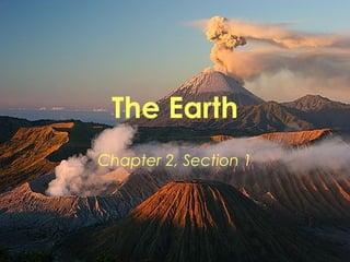
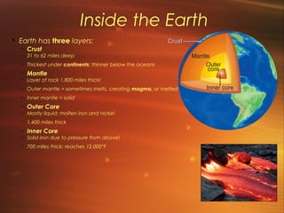
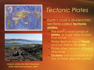
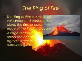
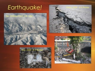
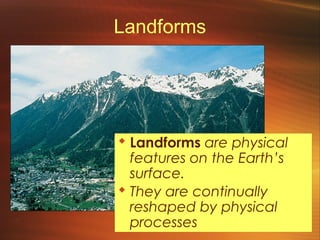
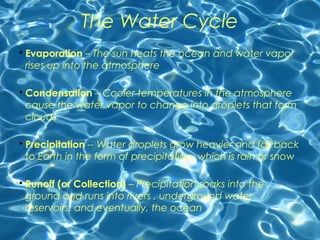
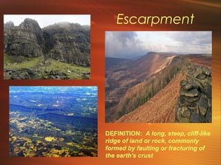
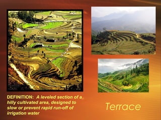
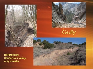
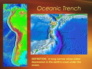
The Earth 
Chapter 2, Section 1
Section Objectives 
• Analyze how processes deep within 
the Earth affect its surface 
• Identify major landforms and 
analyze how they affect life on Earth 
• Identify the causes of earthquakes 
and volcanoes 
• Understand the importance of 
water and the hydrologic cycle.
Inside the Earth 
• Earth has three layers: 
- Crust 
- 31 to 62 miles deep 
- Thickest under continents; thinner below the oceans 
- Mantle 
- Layer of rock 1,800 miles thick! 
- Outer mantle = sometimes melts, creating magma, or melted rock 
- Inner mantle = solid 
- Outer Core 
- Mostly liquid; molten iron and nickel 
- 1,400 miles thick 
- Inner Core 
- Solid iron due to pressure from above! 
- 700 miles thick; reaches 12,000°F
Tectonic Plates 
• Earth’s crust is divided into 
sections called tectonic 
plates: 
– The earth’s crust consist of 
plates, or huge slabs of rock, 
that move 
– Plates float on top of liquid 
rock just below the crust 
– Plates often move in different 
directions 
– Oceans and continents sit on 
top of these gigantic plates! 
Iceland, where the North American 
plate meets the European plate
Plate Tectonics Map
Pangea 
• Scientists believe 
that long ago all 
the continents were 
joined together in a 
land mass called 
Pangea 
• However, 
eventually, the 
continents drifted 
apart - this is called 
“continental drift” 
– Bill Nye: Pangea & Plate
Pangea, cont. 
• The plates are still moving today 
– Plate under the Pacific moves west at 4”/year 
– Plate along west edge of S. America moves east at 
1.8”/year 
• Some scientists believe that in another 250 million 
years, the continents will be rejoined!
When Plates Meet 
• Sometimes plates push against each 
other, leading to one of four things 
– Plates smashing into each other = 
mountain ranges, like the Himalayas 
– Thicker continent plate sliding over a 
thinner ocean plate = volcanic 
mountains, which erupt when pressure 
between plates builds up 
– Plates sliding alongside each other = 
earthquakes along faults, or cracks in the 
earth’s crust 
– Plate movement along faults, like the San 
Andreas Fault in California, can produce 
damaging earthquakes and tsunamis, or 
underwater earthquakes.
The Ring of Fire 
• The Ring of Fire is a circle of 
volcanoes and earthquakes 
along the rim, or outer 
edge of the Pacific Ocean. 
• A large tectonic plate 
under the ocean slides 
against plates in the 
surrounding continents.
Today’s Questions: 
How does the movement of tectonic 
plates impact landforms on earth? 
What landforms are created? 
How does this impact us, 
the people who live on or 
around these landforms?
Earthquakes & Tsunamis 
– An earthquake is a violent shaking of the Earth’s crust 
– Occur along faults, or cracks in the earth’s crust 
– Happens often in the Ring of Fire, but also in other areas, 
– Earthquakes beneath the ocean can produce tsunamis, or large, powerful ocean waves which can cause great destruction along the ocean coast. 
– Earthquake Destruction (2:21) 
– Killer Tsunamis (3:28) 2011 Japanese Tsunami Footage (5:39) 
Earthquake Damage! Tsunami - November 2006!
Earthquake! 
San Andreas Fault, CA, USA 
China, 2008 - 8.0 Richter 
Italy, 2009 - 6.3 Richter 
Pakistan, 2005 - 7.6 Richter
Volcanoes 
• A volcano is a mountain that erupts in an 
explosion of molten rock, gases, and ash. 
– Lava, which is molten rock, flows down the sides of 
the mountain. 
– The Ring of Fire contains more than 75% of the 
world’s volcanoes. 
– In spite of their destructive tendencies, volcanoes 
can benefit, or be useful to, plants and animals by 
making the soil richer 
Volcano 101 (3:04) 
Yellowstone Volcano (1:36)
Landforms 
 Landforms are physical 
features on the Earth’s 
surface. 
 They are continually 
reshaped by physical 
processes
Surface Landforms 
 Mountain – a high, 
steep elevation 
 Hill – slopes upward, 
but is lower and more 
rounded 
 Plain – a level area 
 Plateau – a plain that 
sits high above sea 
level and usually has a 
cliff on all sides
Ocean 
Landforms 
 Mountains, valleys, and volcanoes also 
exist at the bottom of the ocean. 
 Continental shelf – the edge of a 
continent that extends several miles under 
the ocean’s surface 
 At the edge of the shelf, the land slopes 
steeply to the ocean floor 
Diving along the Eurasian Continental Shelf!
Ocean Landforms, cont. 
 Valleys under the 
ocean are called 
trenches 
 Lowest spots in the 
earth’s crust 
 Mariana Trench = 
deepest trench in the 
world, located in the 
west Pacific 
 Dive the Mariana Trench! (:47)
Ocean Landforms, cont. 
Computer imaging of Puerto 
Rico Trench, Atlantic Ocean 
Deep 
Sea - Exploring the Zones (5:54)
The Changing Earth 
• Changes in the earth 
affect plant and animal 
life 
• Erosion: the process by 
which rocks and soil 
slowly break apart and 
are swept away 
• Weathering: when air, 
water, wind, or ice 
slowly wear away rocks 
and soil 
– Bill Nye: Erosion (Cut at 6:48ish)
Erosion and Weather at Work
Waters of the Earth 
Water flowing in rivers 
is essential – or 
necessary – for all 
forms of life! 
 About 70% of the 
earth is water! 
 Most of it is salt 
water, which people 
can’t drink
Fresh Water 
 People use fresh 
water to drink, cook, 
and irrigate crops 
 River – a path of 
water that flows from 
a higher elevation to 
a lower elevation 
 Streams, brooks, and 
creeks – like rivers, only 
smaller 
 Lake – a large body 
of water surrounded 
by land
Salt Water 
 Salt water is a major 
source of seafood 
and a means of 
transportation 
 Oceans – large bodies of 
Salt Water 
 Currents – continuously 
moving flows of water – 
circulate through oceans 
affect the climates on land 
 Seas – Smaller bodies 
of salt water 
 Ex. Red Sea
The Water Cycle 
• Evaporation – The sun heats the ocean and water vapor 
rises up into the atmosphere 
• Condensation – Cooler temperatures in the atmosphere 
cause the water vapor to change into droplets that form 
clouds 
• Precipitation -- Water droplets grow heavier and fall back 
to Earth in the form of precipitation, which is rain or snow 
• Runoff (or Collection) – Precipitation soaks into the 
ground and runs into rivers , underground water 
reservoirs, and eventually, the ocean
Percentage of Water on Earth: 
– 96.5% Oceans 
– 1.7% Ground Water 
– 1.8% Surface Water 
– .024% Other Water 
– (Ground ice, atmospheric water vapor, marshes/wetlands, 
and in lorganisms 
–Of the amount of water on earth, 
only 2.5% is available for human use! 
• Water Cycle Rap 
• Thirstin's Water Cycle 
• Soccer Game 
• Stuck In Your Head Song
Landforms: 
An Amazing Variety!
Escarpment 
DEFINITION: A long, steep, cliff-like 
ridge of land or rock, commonly 
formed by faulting or fracturing of 
the earth's crust
Terrace 
DEFINITION: A leveled section of a 
hilly cultivated area, designed to 
slow or prevent rapid run-off of 
irrigation water
Valley 
DEFINITION: The 
low area between 
mountains or hills
Gully 
DEFINITION: 
Similar to a valley, 
only smaller
Archipelago 
DEFINITION: A 
large group or 
chain of islands
Coral Reef 
DEFINITION: a reef or underwater ridge 
composed mainly of coral and other organic 
matter which has hardened into limestone.
Cove 
DEFINITION: A 
round indentation 
or recess with a 
narrow entrance, 
located in the 
shoreline of a sea, 
lake, or river.
Headland 
DEFINITION: An 
area of land with 
water on three sides 
(large headlands are 
called peninsulas).
Lagoon 
DEFINITION: An area of salt 
water separated from a larger 
sea by a sandbank or coral reef
Cave 
DEFINITION: A natural 
underground opening in a 
cliff or rock, big enough for a 
person to enter.
Gorge & Canyon 
DEFINITION: A deep valley 
with steep sides, formed 
by streams carving 
through plateaus. (A gorge 
is a small canyon!) 
Above: Royal Gorge, CO 
Right: Grand Canyon
Waterfall 
DEFINITION: A flow of water that drops over 
rocks, usually from a height of several feet.
Big Spring, Ozarks, MO (Largest spring in the U.S.! 
Spring 
Right: Grand Prismatic 
Spring, Yellowstone 
(160 degrees F!) 
DEFINITION: 
A place where 
groundwater flows 
out of the ground.
Crevasse 
Gorner Glacier, 
Zermatt, Switzerland 
Easton Glacier, 
Mount Baker, WA 
Exploring bottom of 
crevasse in Antarctica 
DEFINITION: 
A crack in a 
glacier or 
snow field.
Fjord Above: Fjords on coast of Greenland 
(Bottom is largest fjord in the world!) 
DEFINITION: A valley 
with steep sides, which 
is below sea level and 
filled with salt water.
Mountain 
DEFINITION: A natural elevation of 
the earth's surface rising to a summit, 
steeper and higher than a hill.
Cinder Cone 
DEFINITION: A small, 
cone-shaped volcano 
built of ash and cinders.
Oceanic Trench 
DEFINITION: A long narrow steep-sided 
depression in the earth's crust under the 
ocean.
Lava Dome 
DEFINITION: A mound-shaped 
growth resulting from the 
eruption of lava in a volcano
Tea Table 
DEFINITION: A rock 
formation that has been 
eroded away in the shape 
of a table
Limestone Pavement 
DEFINITION: Exposed limestone 
rock that looks like artificial 
pavement with cracks in it.
Hoodoo 
DEFINITION: 
A tall, thin 
spire of rock 
that sticks up 
from the 
bottom of an 
dry drainage 
basin or 
badland.
Any questions?

The Earth

  • 1.
    The Earth Chapter2, Section 1
  • 2.
    Section Objectives •Analyze how processes deep within the Earth affect its surface • Identify major landforms and analyze how they affect life on Earth • Identify the causes of earthquakes and volcanoes • Understand the importance of water and the hydrologic cycle.
  • 3.
    Inside the Earth • Earth has three layers: - Crust - 31 to 62 miles deep - Thickest under continents; thinner below the oceans - Mantle - Layer of rock 1,800 miles thick! - Outer mantle = sometimes melts, creating magma, or melted rock - Inner mantle = solid - Outer Core - Mostly liquid; molten iron and nickel - 1,400 miles thick - Inner Core - Solid iron due to pressure from above! - 700 miles thick; reaches 12,000°F
  • 4.
    Tectonic Plates •Earth’s crust is divided into sections called tectonic plates: – The earth’s crust consist of plates, or huge slabs of rock, that move – Plates float on top of liquid rock just below the crust – Plates often move in different directions – Oceans and continents sit on top of these gigantic plates! Iceland, where the North American plate meets the European plate
  • 5.
  • 6.
    Pangea • Scientistsbelieve that long ago all the continents were joined together in a land mass called Pangea • However, eventually, the continents drifted apart - this is called “continental drift” – Bill Nye: Pangea & Plate
  • 7.
    Pangea, cont. •The plates are still moving today – Plate under the Pacific moves west at 4”/year – Plate along west edge of S. America moves east at 1.8”/year • Some scientists believe that in another 250 million years, the continents will be rejoined!
  • 8.
    When Plates Meet • Sometimes plates push against each other, leading to one of four things – Plates smashing into each other = mountain ranges, like the Himalayas – Thicker continent plate sliding over a thinner ocean plate = volcanic mountains, which erupt when pressure between plates builds up – Plates sliding alongside each other = earthquakes along faults, or cracks in the earth’s crust – Plate movement along faults, like the San Andreas Fault in California, can produce damaging earthquakes and tsunamis, or underwater earthquakes.
  • 9.
    The Ring ofFire • The Ring of Fire is a circle of volcanoes and earthquakes along the rim, or outer edge of the Pacific Ocean. • A large tectonic plate under the ocean slides against plates in the surrounding continents.
  • 10.
    Today’s Questions: Howdoes the movement of tectonic plates impact landforms on earth? What landforms are created? How does this impact us, the people who live on or around these landforms?
  • 11.
    Earthquakes & Tsunamis – An earthquake is a violent shaking of the Earth’s crust – Occur along faults, or cracks in the earth’s crust – Happens often in the Ring of Fire, but also in other areas, – Earthquakes beneath the ocean can produce tsunamis, or large, powerful ocean waves which can cause great destruction along the ocean coast. – Earthquake Destruction (2:21) – Killer Tsunamis (3:28) 2011 Japanese Tsunami Footage (5:39) Earthquake Damage! Tsunami - November 2006!
  • 12.
    Earthquake! San AndreasFault, CA, USA China, 2008 - 8.0 Richter Italy, 2009 - 6.3 Richter Pakistan, 2005 - 7.6 Richter
  • 13.
    Volcanoes • Avolcano is a mountain that erupts in an explosion of molten rock, gases, and ash. – Lava, which is molten rock, flows down the sides of the mountain. – The Ring of Fire contains more than 75% of the world’s volcanoes. – In spite of their destructive tendencies, volcanoes can benefit, or be useful to, plants and animals by making the soil richer Volcano 101 (3:04) Yellowstone Volcano (1:36)
  • 14.
    Landforms  Landformsare physical features on the Earth’s surface.  They are continually reshaped by physical processes
  • 15.
    Surface Landforms Mountain – a high, steep elevation  Hill – slopes upward, but is lower and more rounded  Plain – a level area  Plateau – a plain that sits high above sea level and usually has a cliff on all sides
  • 16.
    Ocean Landforms Mountains, valleys, and volcanoes also exist at the bottom of the ocean.  Continental shelf – the edge of a continent that extends several miles under the ocean’s surface  At the edge of the shelf, the land slopes steeply to the ocean floor Diving along the Eurasian Continental Shelf!
  • 17.
    Ocean Landforms, cont.  Valleys under the ocean are called trenches  Lowest spots in the earth’s crust  Mariana Trench = deepest trench in the world, located in the west Pacific  Dive the Mariana Trench! (:47)
  • 18.
    Ocean Landforms, cont. Computer imaging of Puerto Rico Trench, Atlantic Ocean Deep Sea - Exploring the Zones (5:54)
  • 19.
    The Changing Earth • Changes in the earth affect plant and animal life • Erosion: the process by which rocks and soil slowly break apart and are swept away • Weathering: when air, water, wind, or ice slowly wear away rocks and soil – Bill Nye: Erosion (Cut at 6:48ish)
  • 20.
  • 21.
    Waters of theEarth Water flowing in rivers is essential – or necessary – for all forms of life!  About 70% of the earth is water!  Most of it is salt water, which people can’t drink
  • 22.
    Fresh Water People use fresh water to drink, cook, and irrigate crops  River – a path of water that flows from a higher elevation to a lower elevation  Streams, brooks, and creeks – like rivers, only smaller  Lake – a large body of water surrounded by land
  • 23.
    Salt Water Salt water is a major source of seafood and a means of transportation  Oceans – large bodies of Salt Water  Currents – continuously moving flows of water – circulate through oceans affect the climates on land  Seas – Smaller bodies of salt water  Ex. Red Sea
  • 24.
    The Water Cycle • Evaporation – The sun heats the ocean and water vapor rises up into the atmosphere • Condensation – Cooler temperatures in the atmosphere cause the water vapor to change into droplets that form clouds • Precipitation -- Water droplets grow heavier and fall back to Earth in the form of precipitation, which is rain or snow • Runoff (or Collection) – Precipitation soaks into the ground and runs into rivers , underground water reservoirs, and eventually, the ocean
  • 26.
    Percentage of Wateron Earth: – 96.5% Oceans – 1.7% Ground Water – 1.8% Surface Water – .024% Other Water – (Ground ice, atmospheric water vapor, marshes/wetlands, and in lorganisms –Of the amount of water on earth, only 2.5% is available for human use! • Water Cycle Rap • Thirstin's Water Cycle • Soccer Game • Stuck In Your Head Song
  • 27.
  • 28.
    Escarpment DEFINITION: Along, steep, cliff-like ridge of land or rock, commonly formed by faulting or fracturing of the earth's crust
  • 29.
    Terrace DEFINITION: Aleveled section of a hilly cultivated area, designed to slow or prevent rapid run-off of irrigation water
  • 30.
    Valley DEFINITION: The low area between mountains or hills
  • 31.
    Gully DEFINITION: Similarto a valley, only smaller
  • 32.
    Archipelago DEFINITION: A large group or chain of islands
  • 33.
    Coral Reef DEFINITION:a reef or underwater ridge composed mainly of coral and other organic matter which has hardened into limestone.
  • 34.
    Cove DEFINITION: A round indentation or recess with a narrow entrance, located in the shoreline of a sea, lake, or river.
  • 35.
    Headland DEFINITION: An area of land with water on three sides (large headlands are called peninsulas).
  • 36.
    Lagoon DEFINITION: Anarea of salt water separated from a larger sea by a sandbank or coral reef
  • 37.
    Cave DEFINITION: Anatural underground opening in a cliff or rock, big enough for a person to enter.
  • 38.
    Gorge & Canyon DEFINITION: A deep valley with steep sides, formed by streams carving through plateaus. (A gorge is a small canyon!) Above: Royal Gorge, CO Right: Grand Canyon
  • 39.
    Waterfall DEFINITION: Aflow of water that drops over rocks, usually from a height of several feet.
  • 40.
    Big Spring, Ozarks,MO (Largest spring in the U.S.! Spring Right: Grand Prismatic Spring, Yellowstone (160 degrees F!) DEFINITION: A place where groundwater flows out of the ground.
  • 41.
    Crevasse Gorner Glacier, Zermatt, Switzerland Easton Glacier, Mount Baker, WA Exploring bottom of crevasse in Antarctica DEFINITION: A crack in a glacier or snow field.
  • 42.
    Fjord Above: Fjordson coast of Greenland (Bottom is largest fjord in the world!) DEFINITION: A valley with steep sides, which is below sea level and filled with salt water.
  • 43.
    Mountain DEFINITION: Anatural elevation of the earth's surface rising to a summit, steeper and higher than a hill.
  • 44.
    Cinder Cone DEFINITION:A small, cone-shaped volcano built of ash and cinders.
  • 45.
    Oceanic Trench DEFINITION:A long narrow steep-sided depression in the earth's crust under the ocean.
  • 46.
    Lava Dome DEFINITION:A mound-shaped growth resulting from the eruption of lava in a volcano
  • 47.
    Tea Table DEFINITION:A rock formation that has been eroded away in the shape of a table
  • 48.
    Limestone Pavement DEFINITION:Exposed limestone rock that looks like artificial pavement with cracks in it.
  • 49.
    Hoodoo DEFINITION: Atall, thin spire of rock that sticks up from the bottom of an dry drainage basin or badland.
  • 50.

Editor's Notes

  • #2 <number>
  • #4 <number>
  • #15 <number>
  • #16 <number>
  • #17 <number>
  • #18 <number>
  • #19 <number>
  • #22 <number>
  • #23 <number>