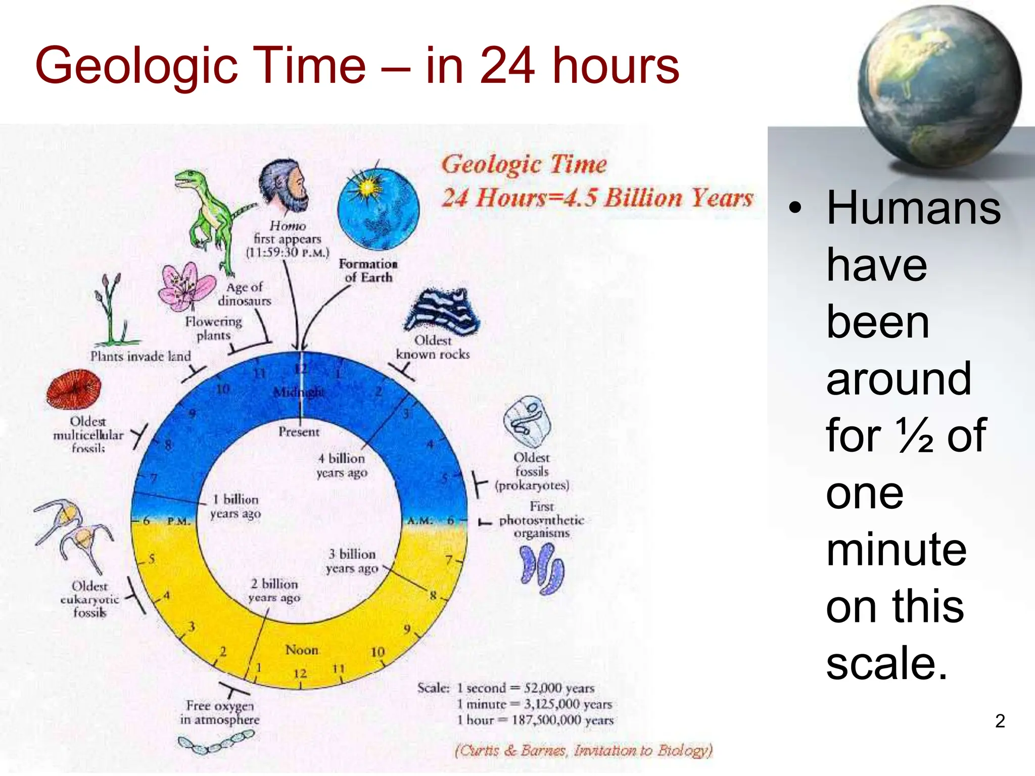
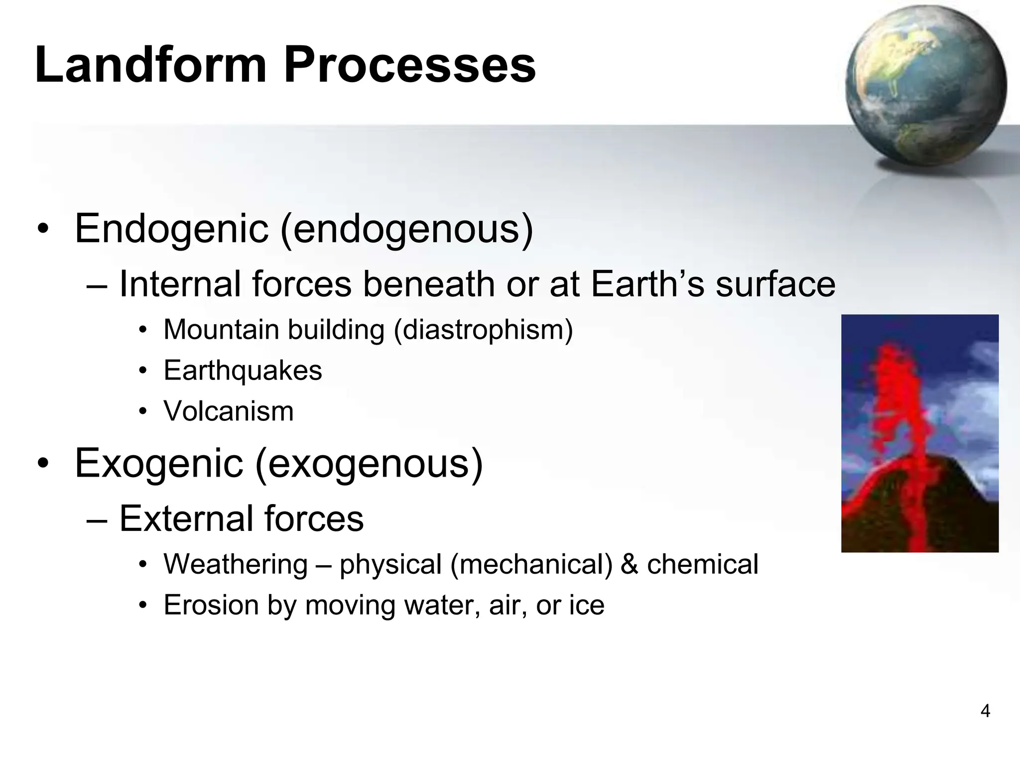
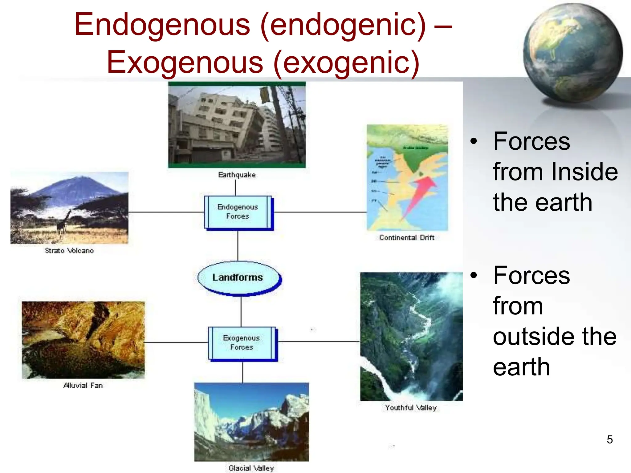
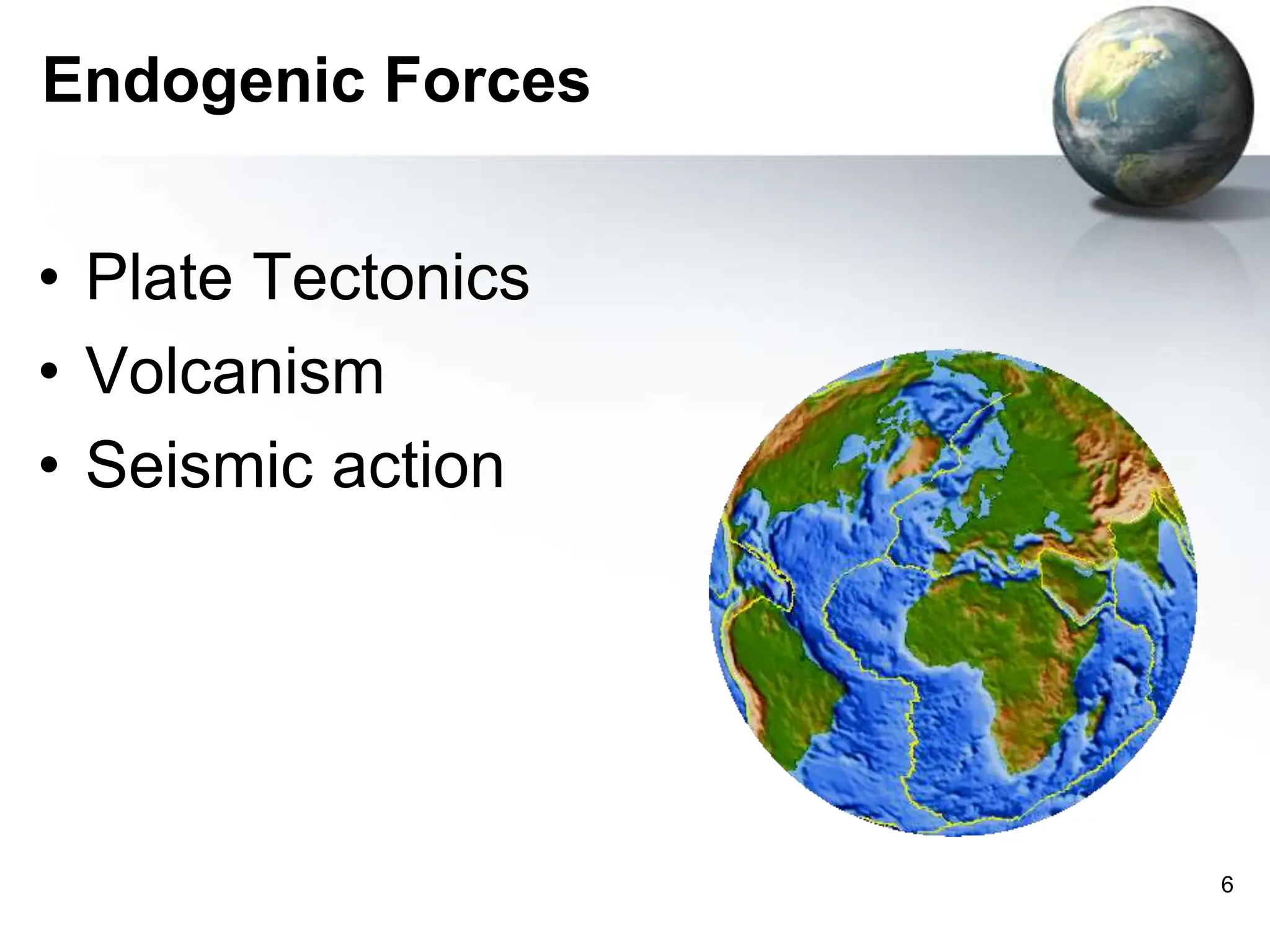
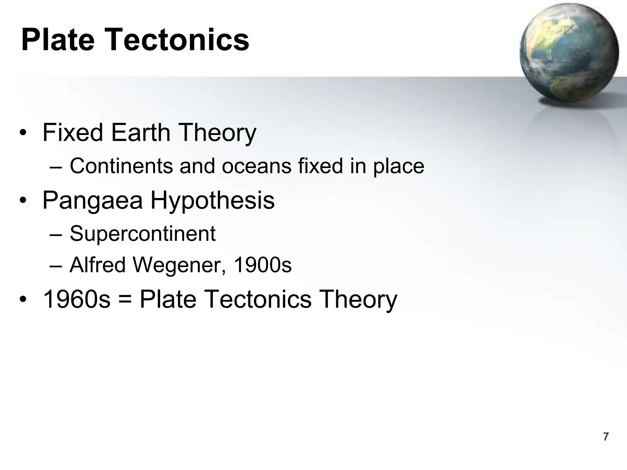
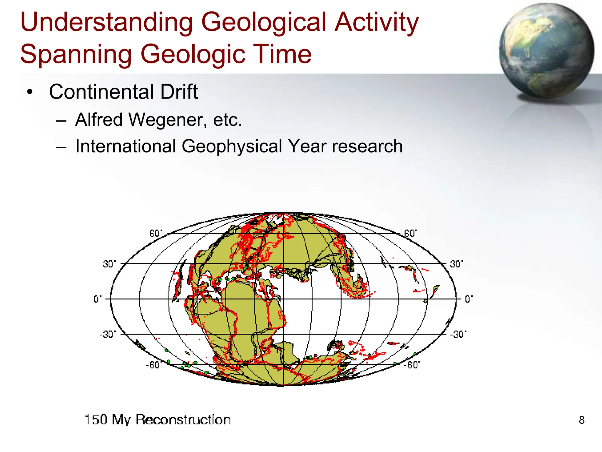
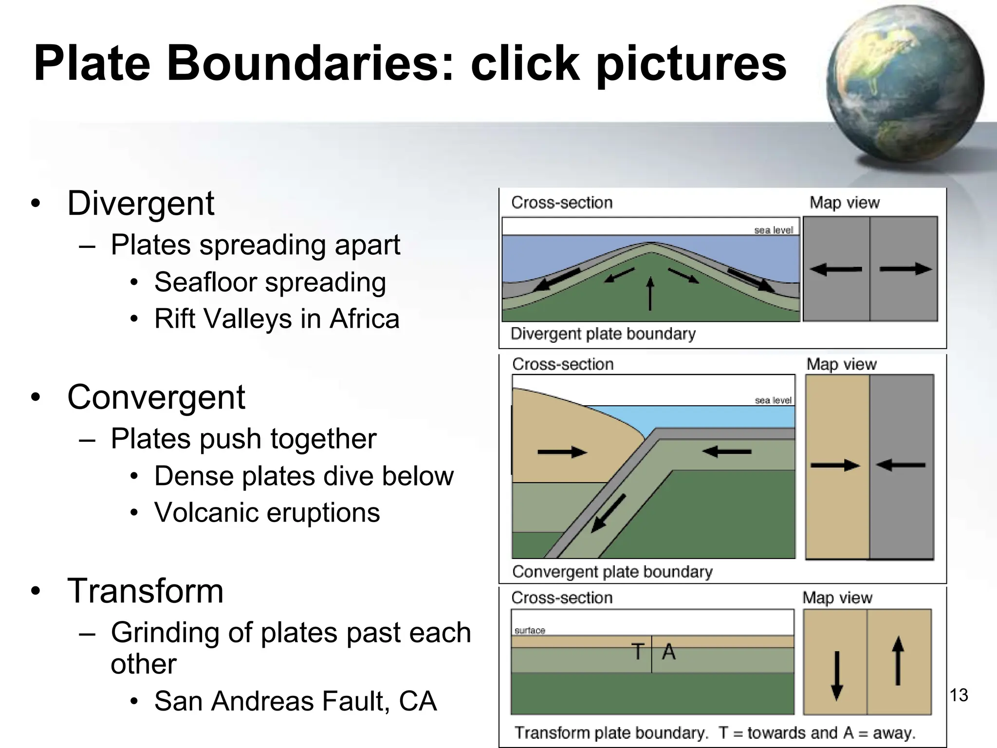
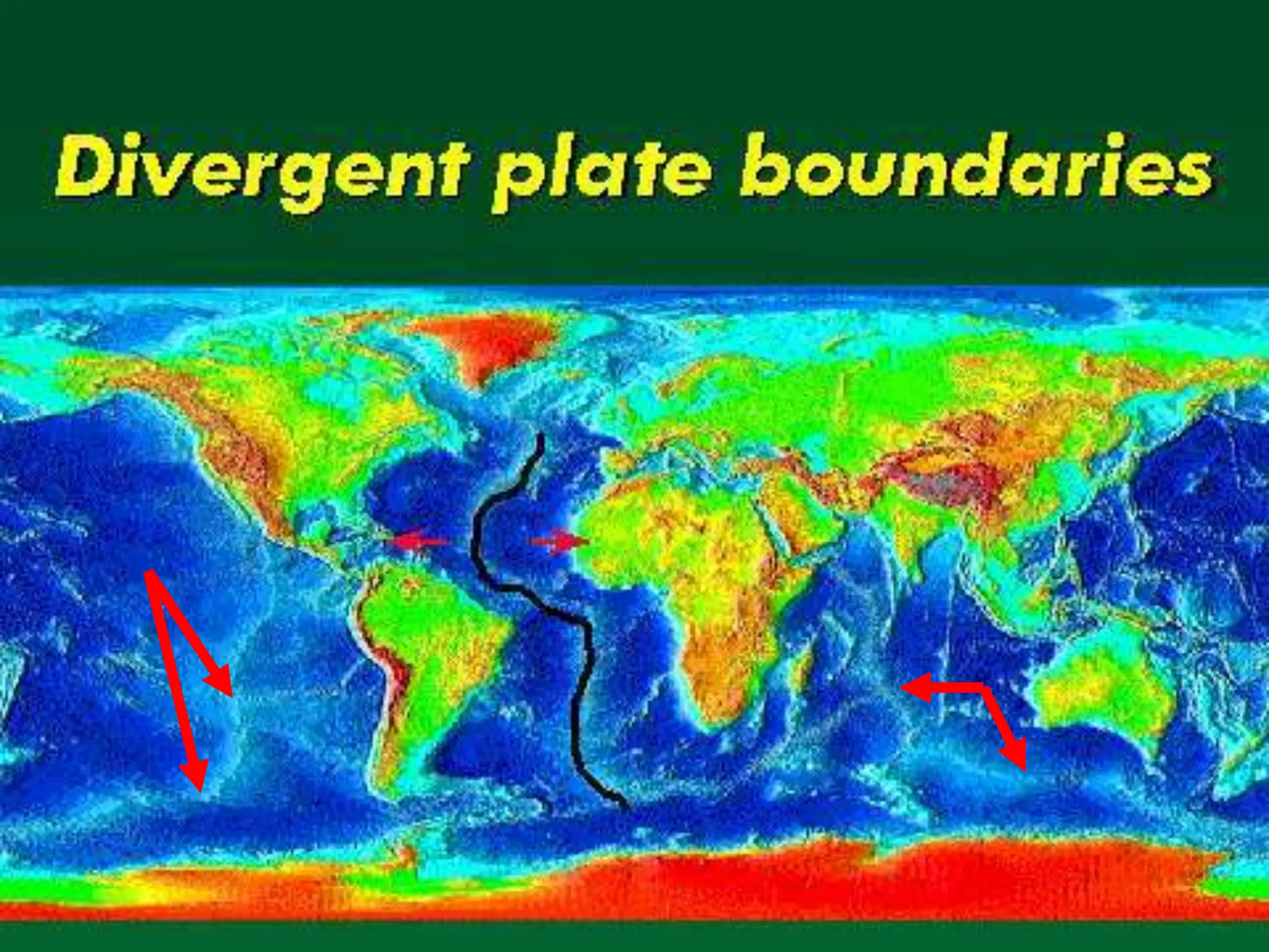
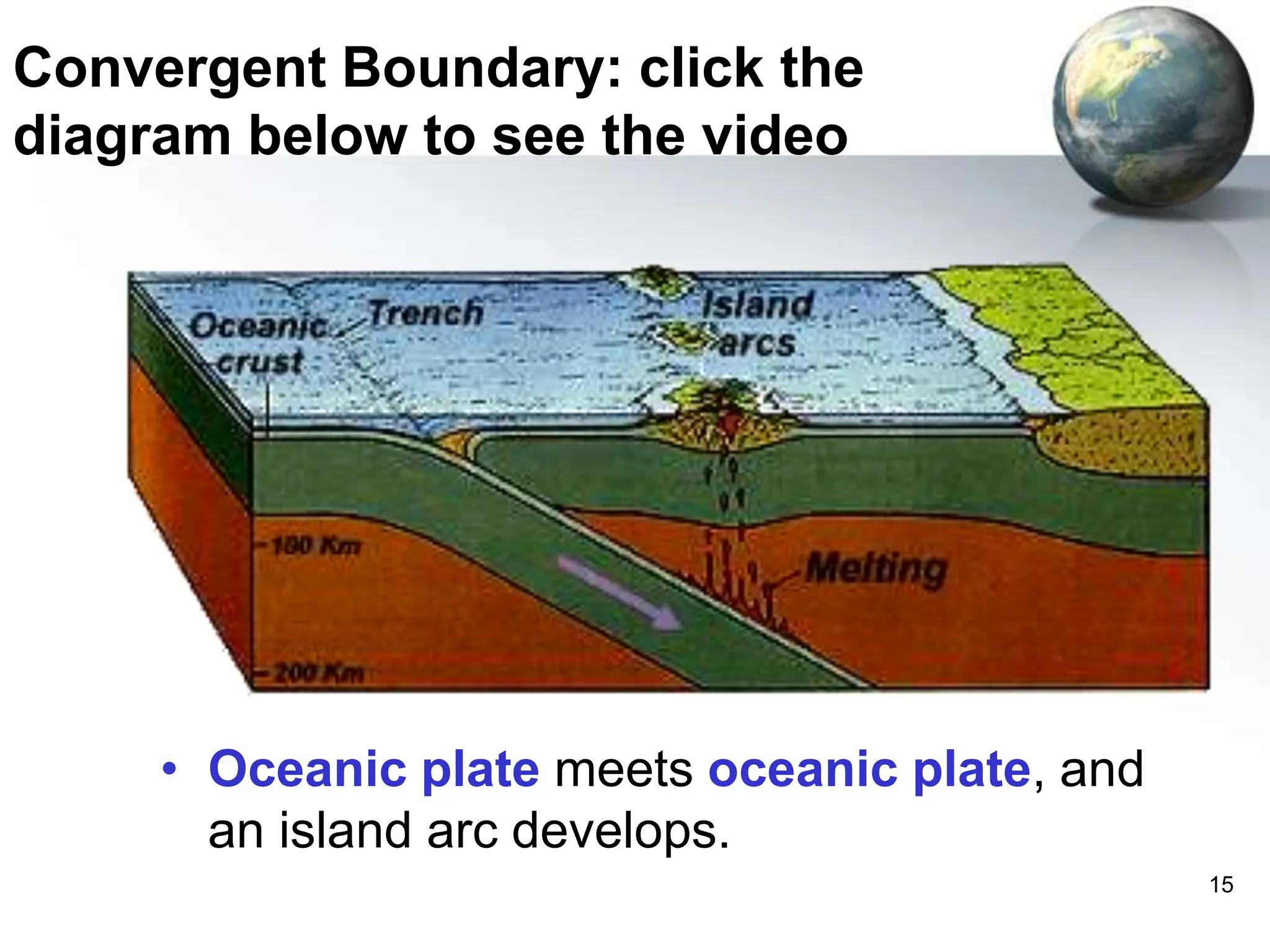
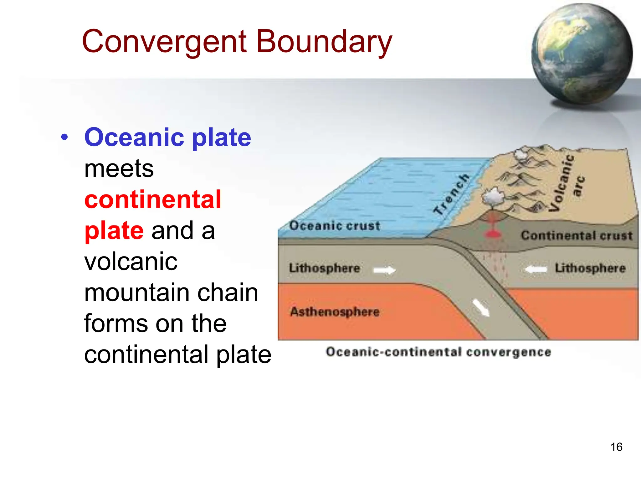
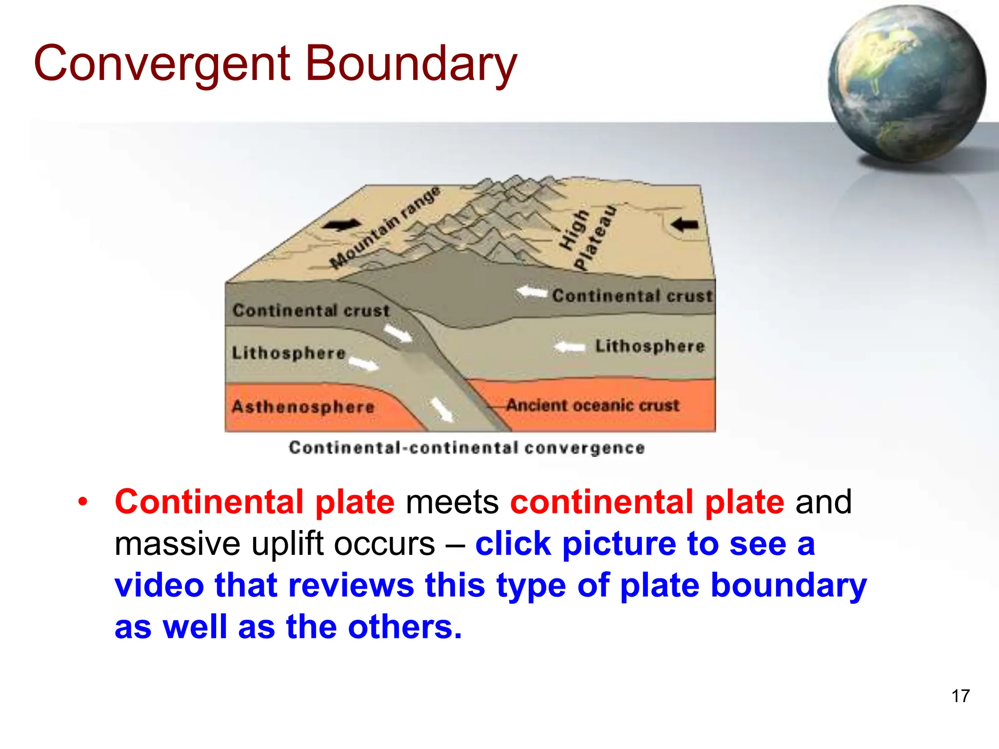
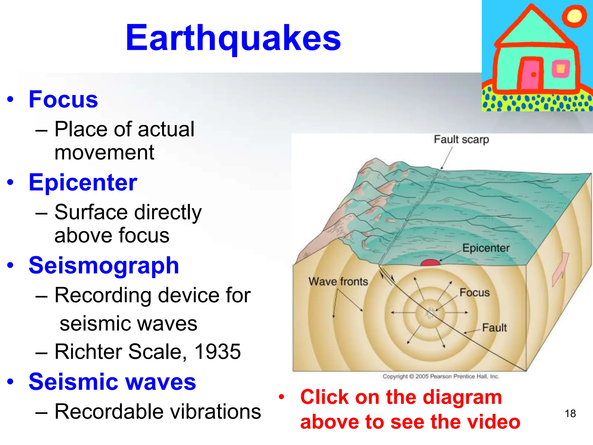
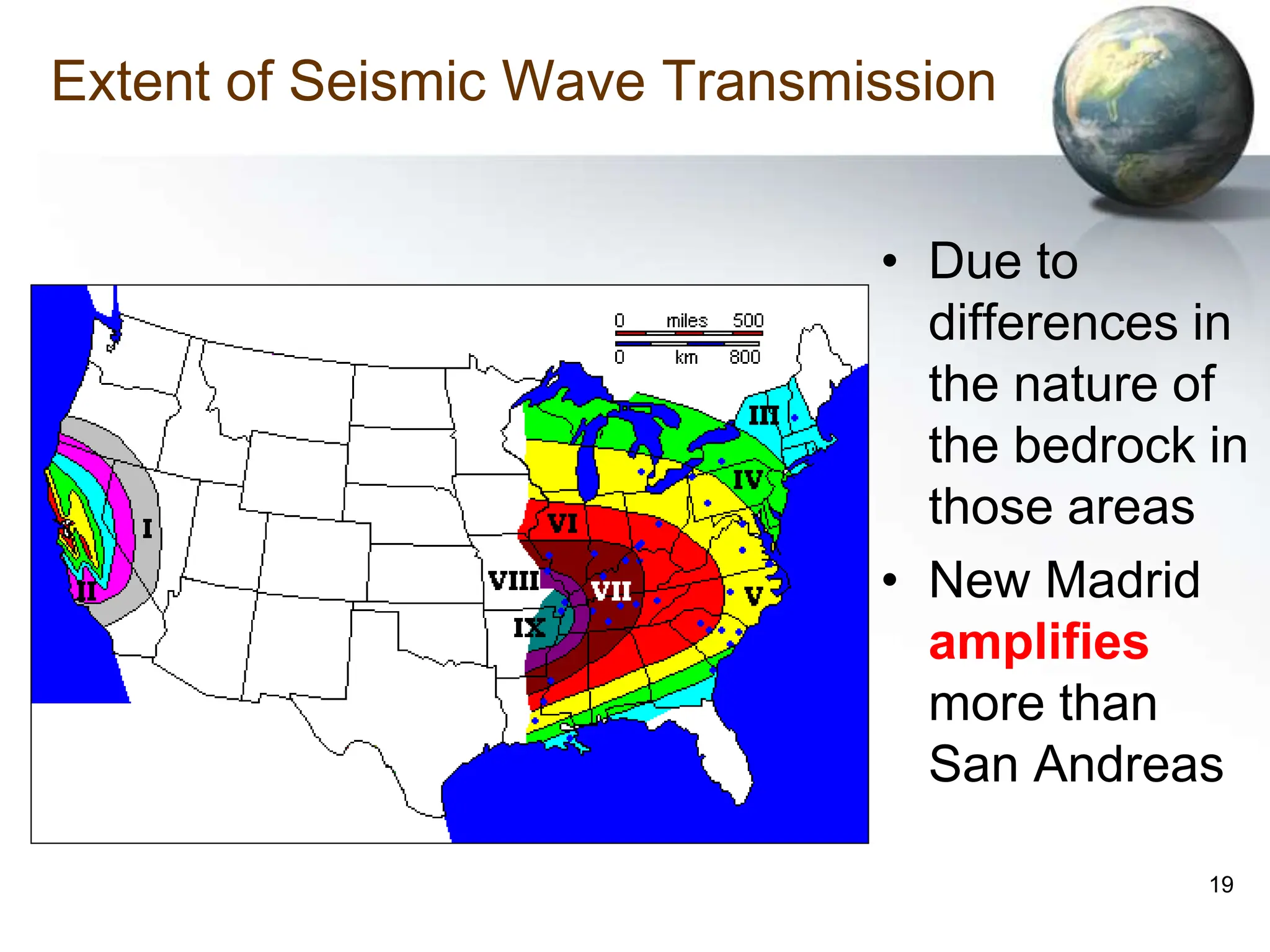
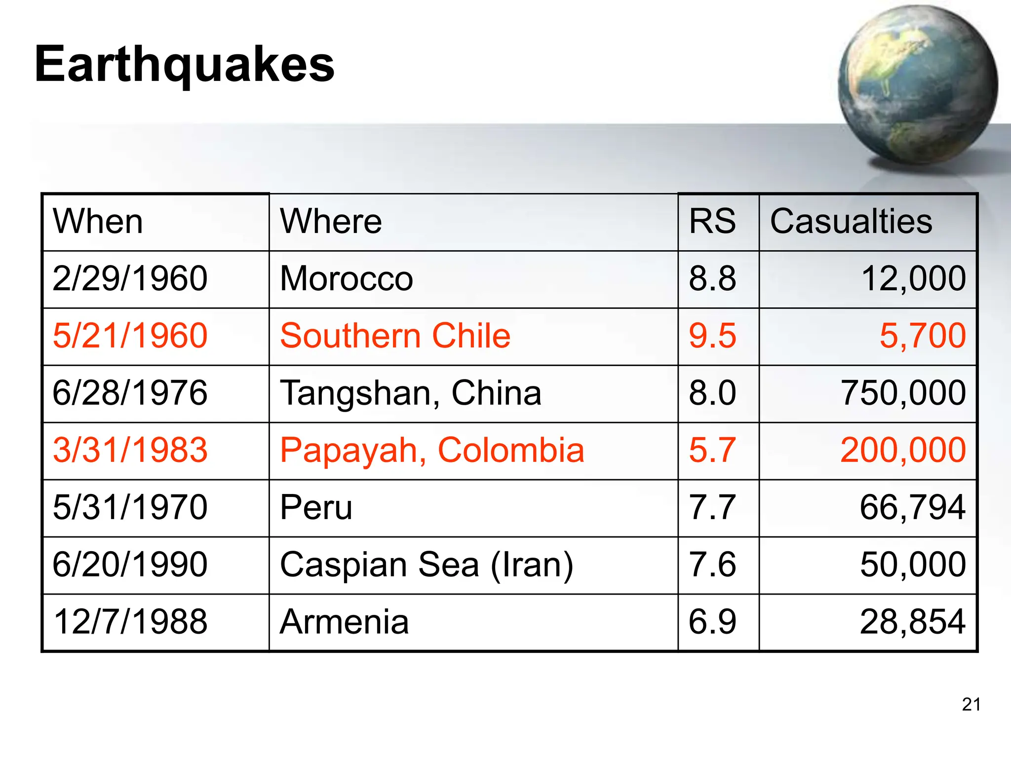
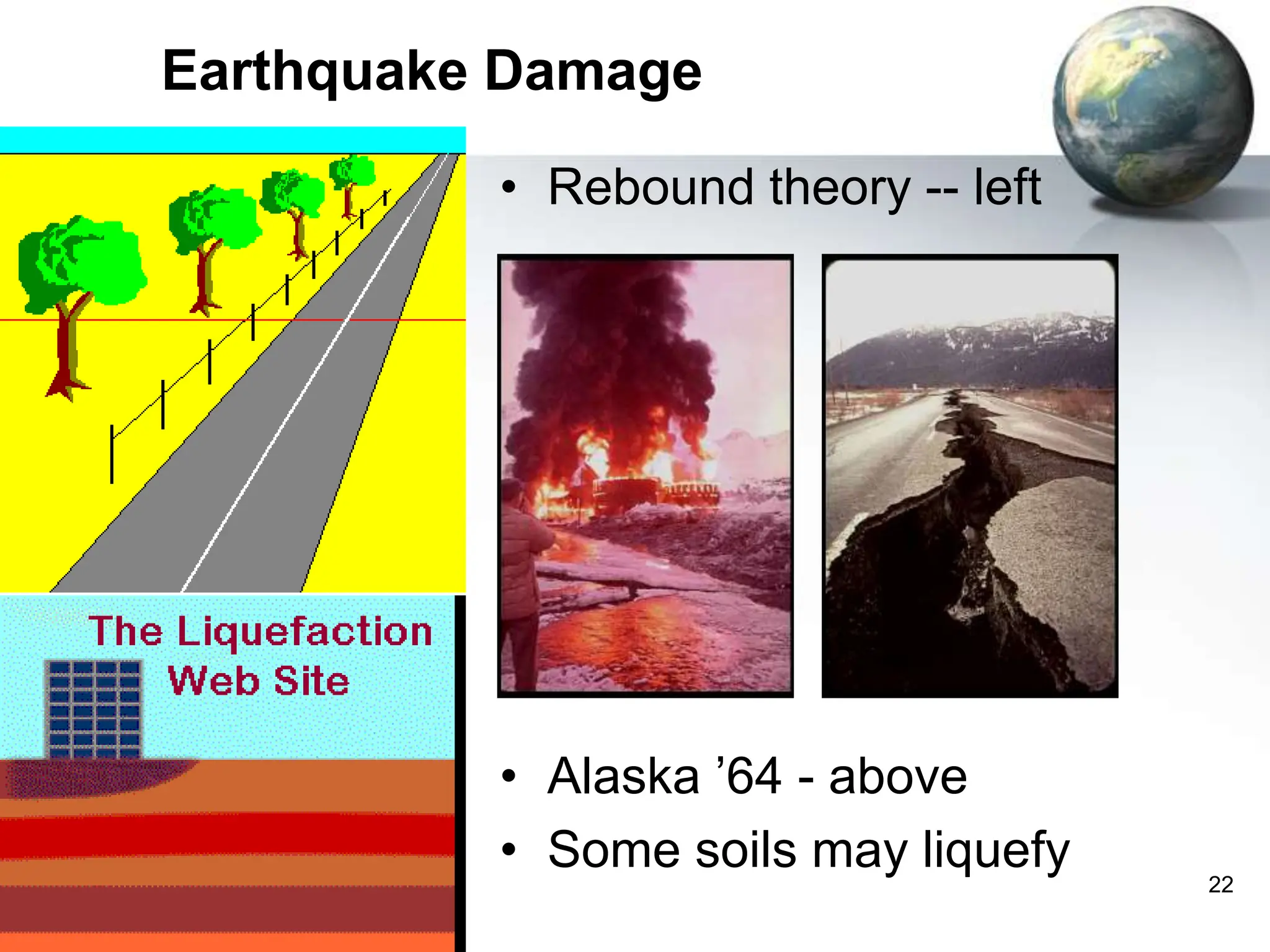
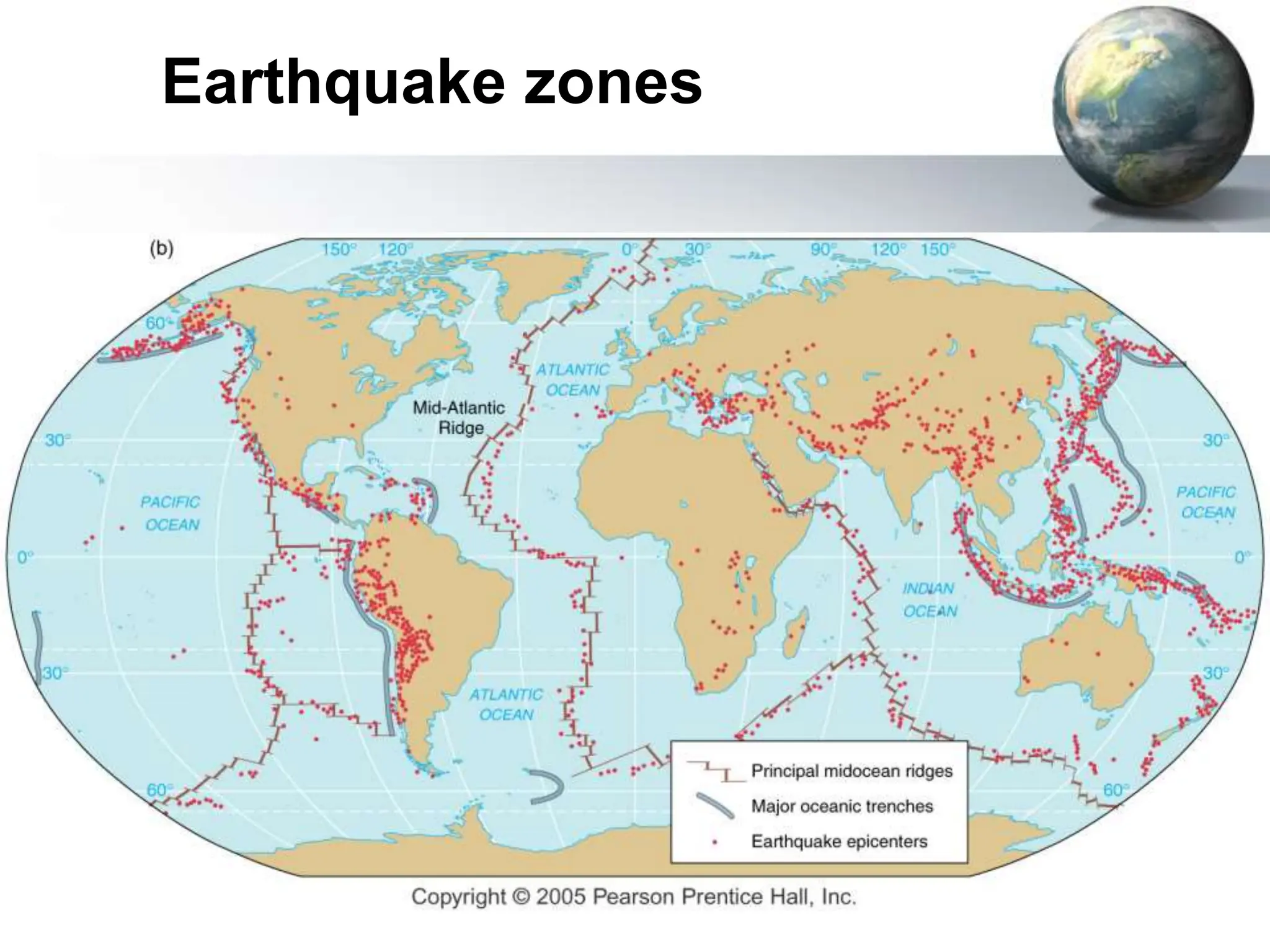
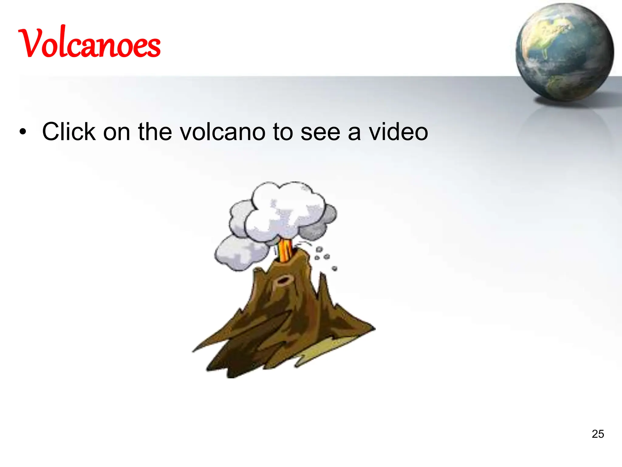
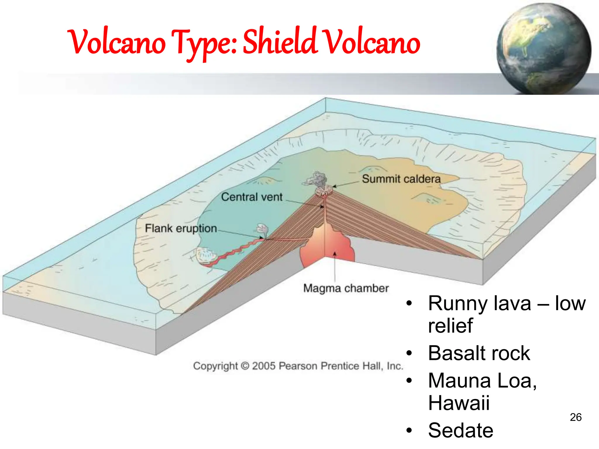
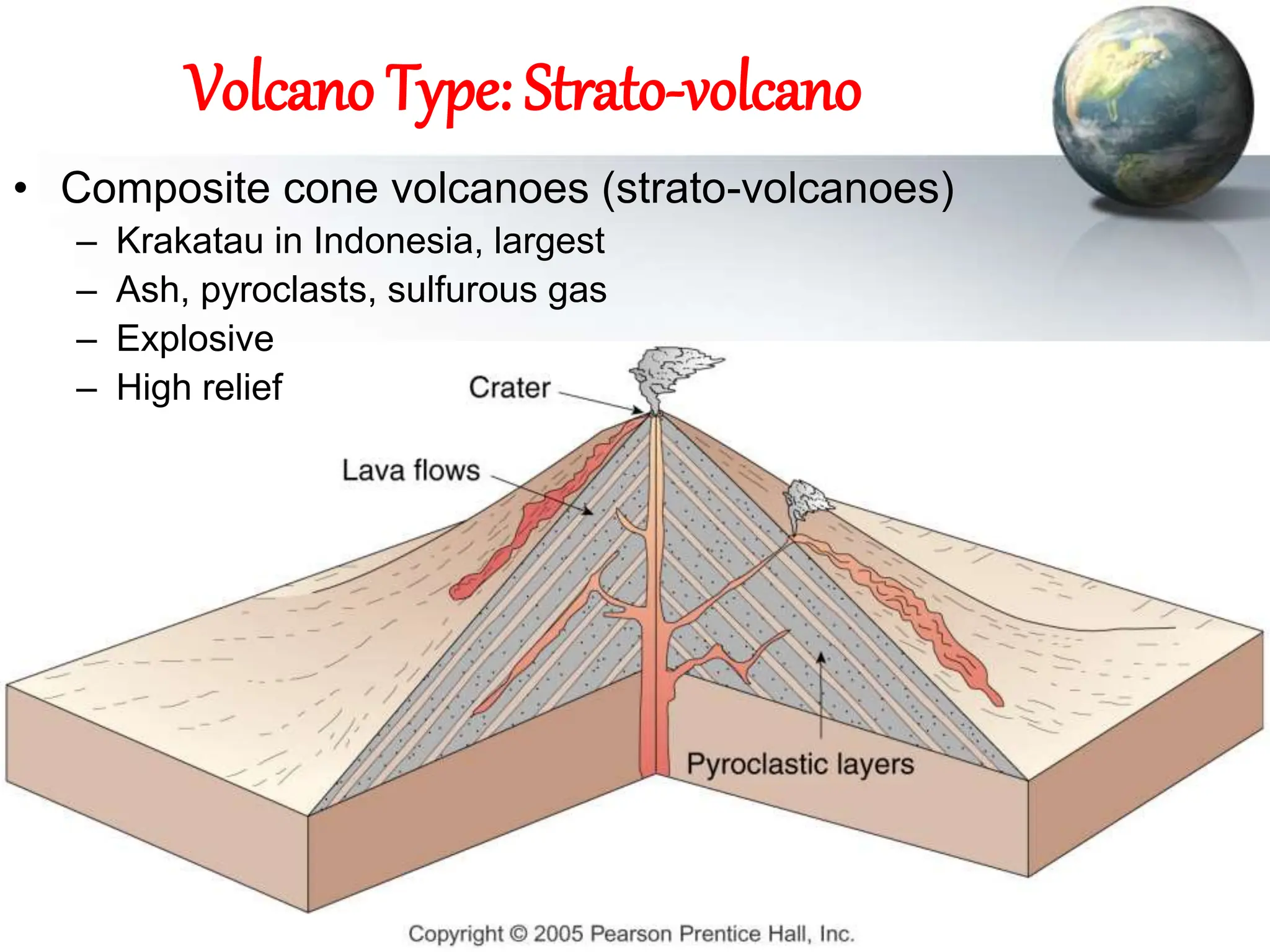
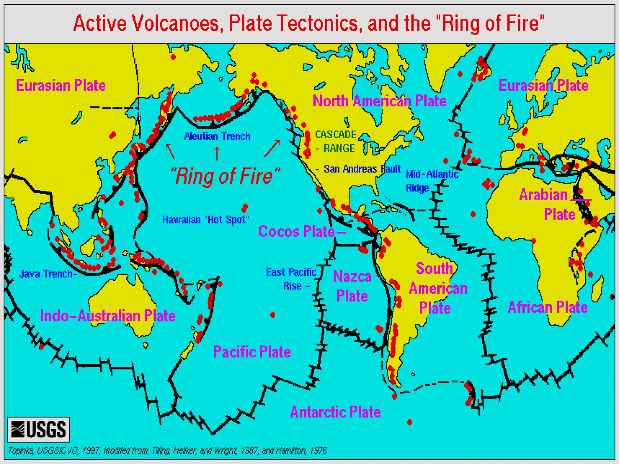
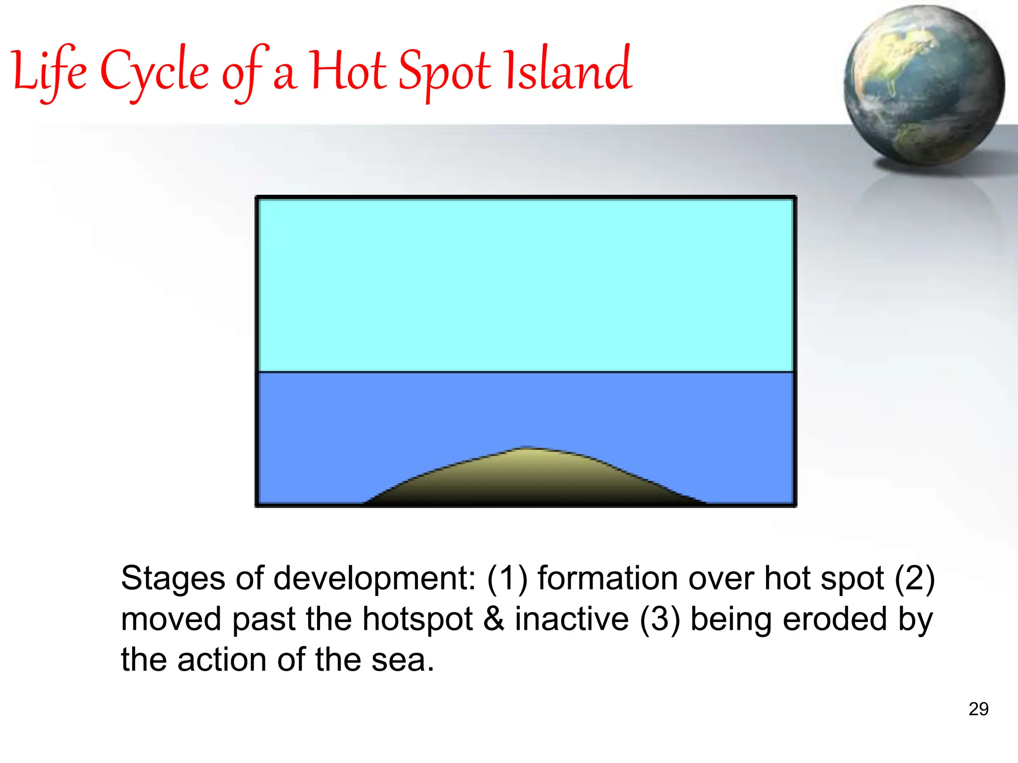
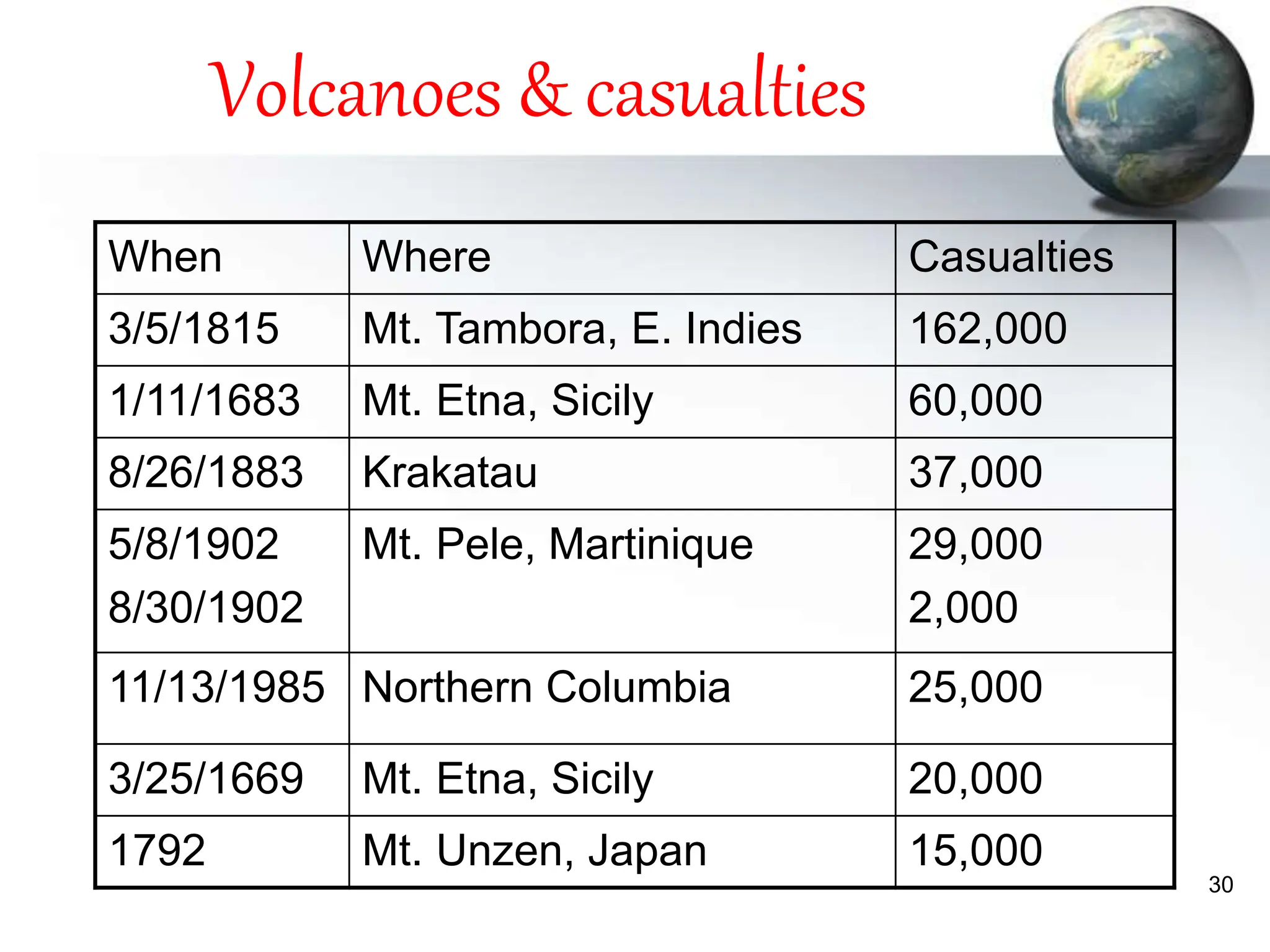
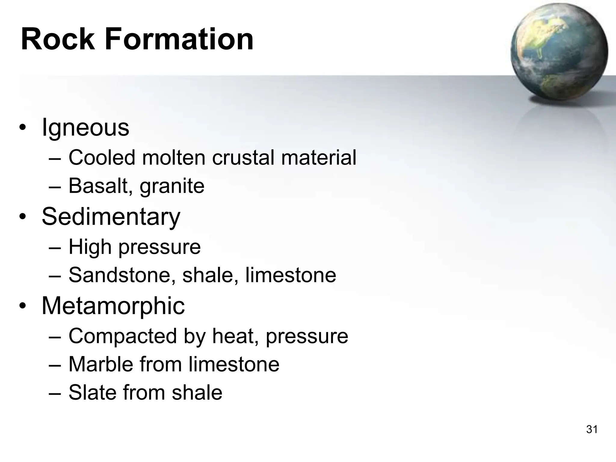
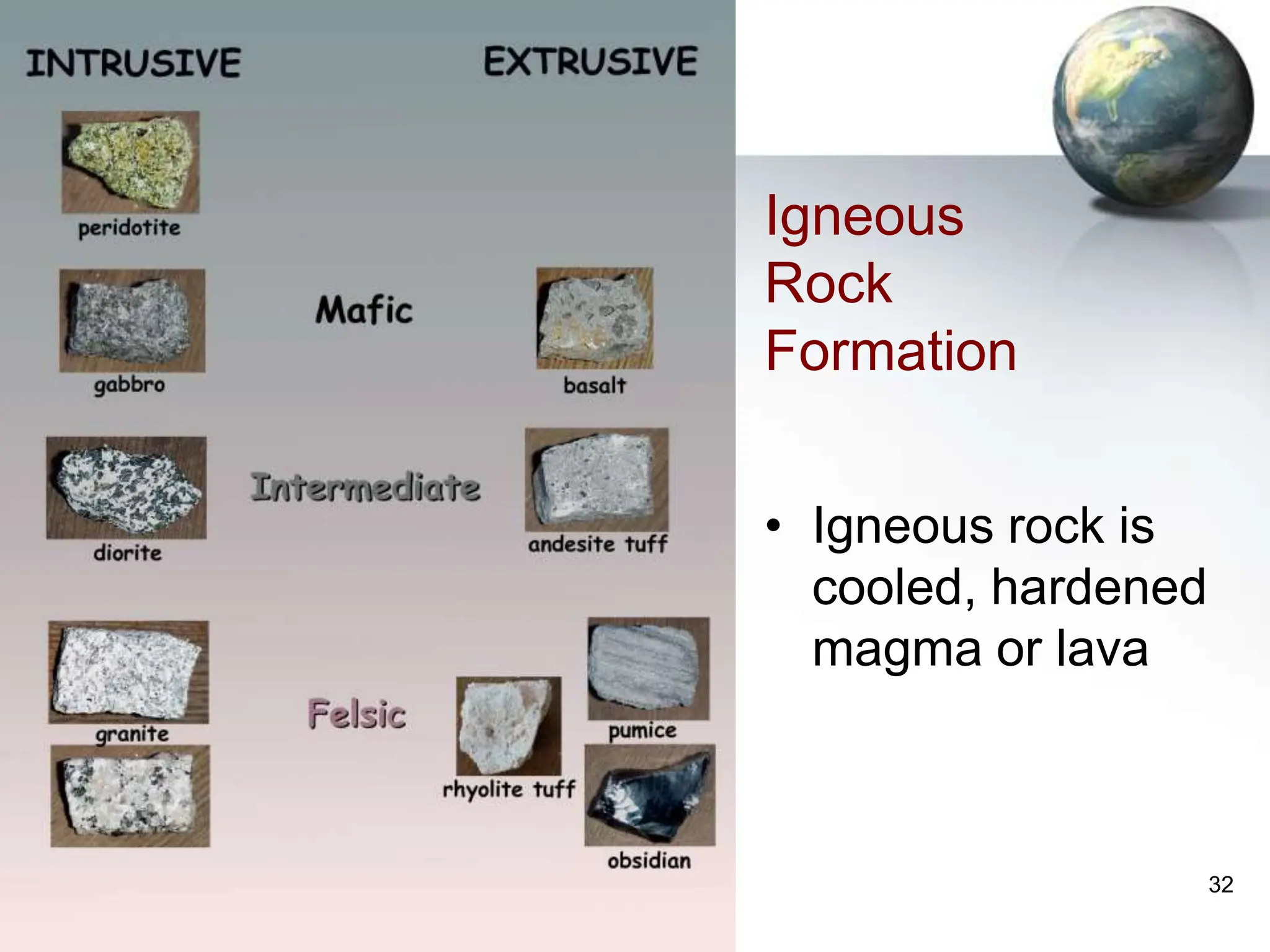
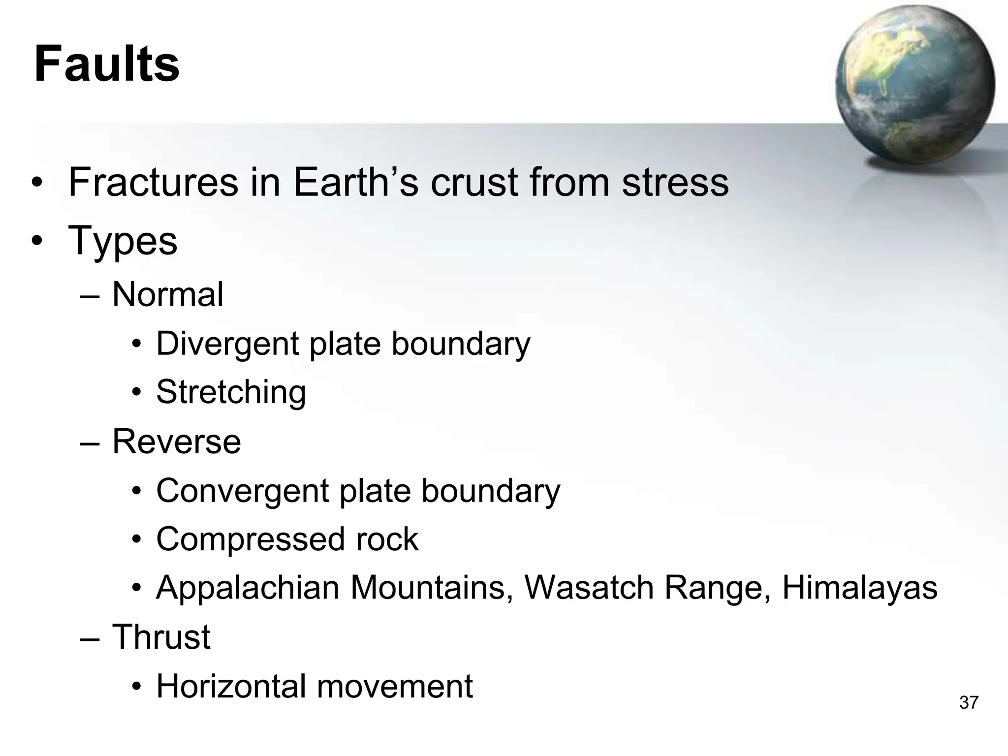
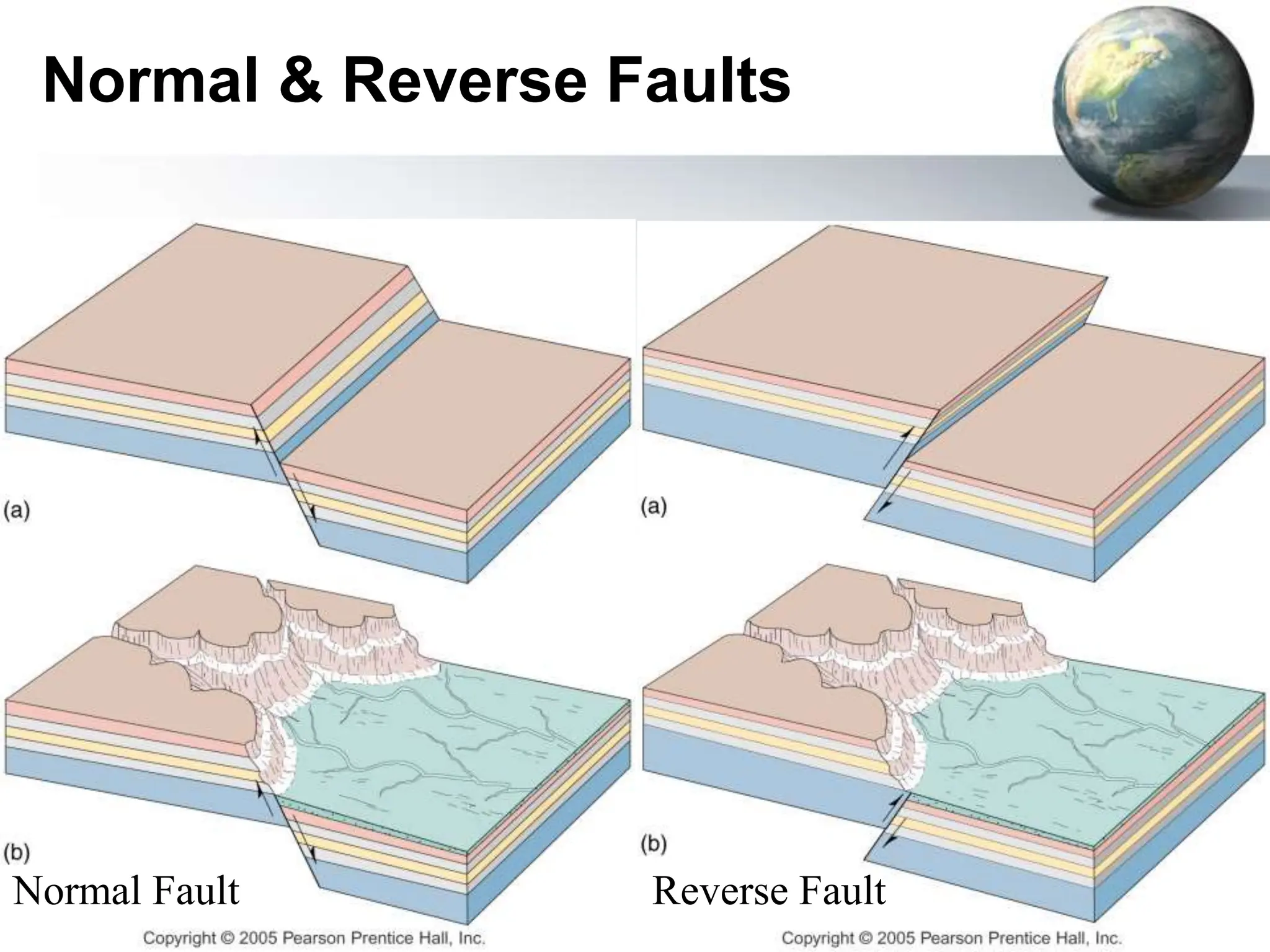
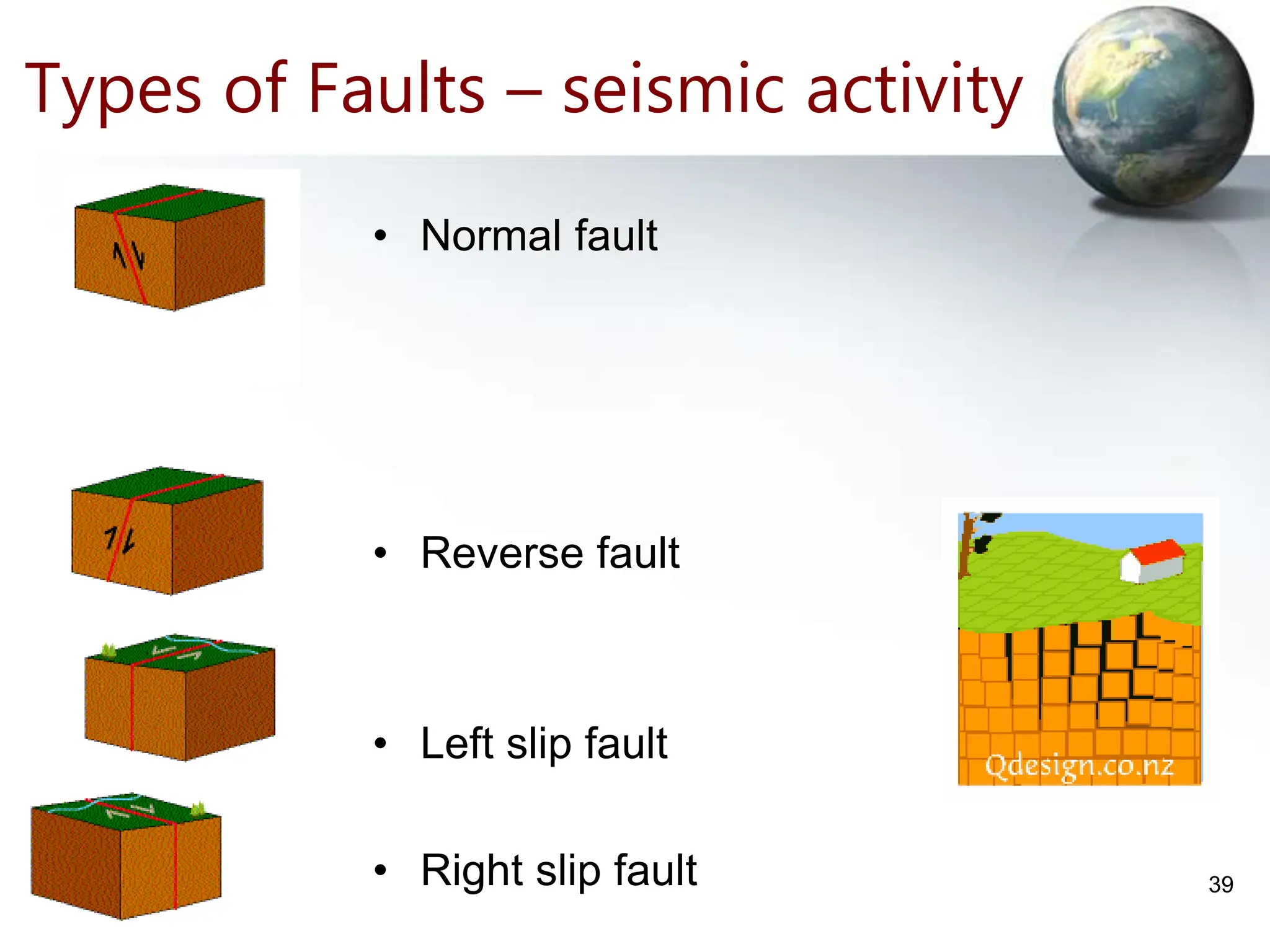
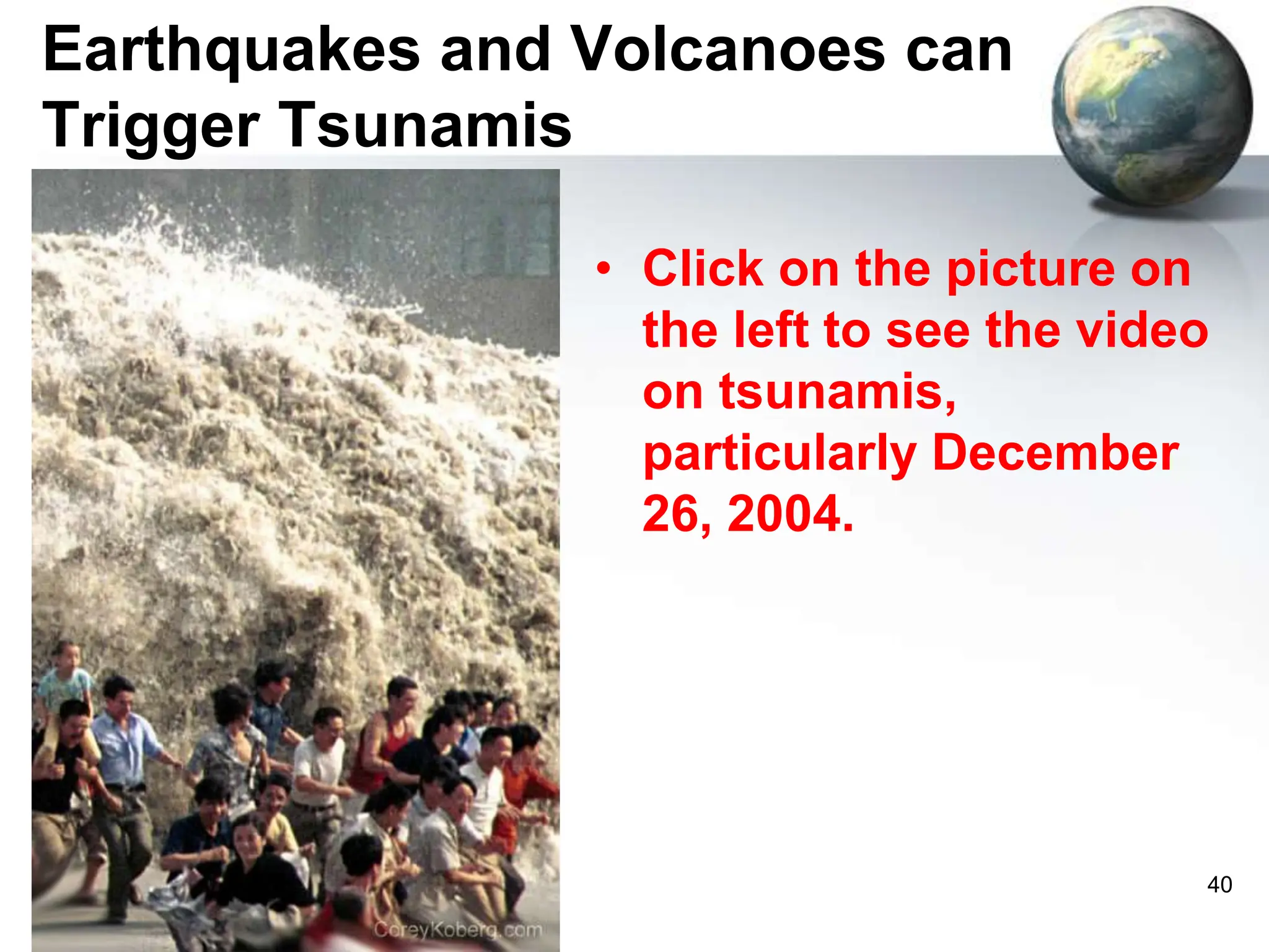
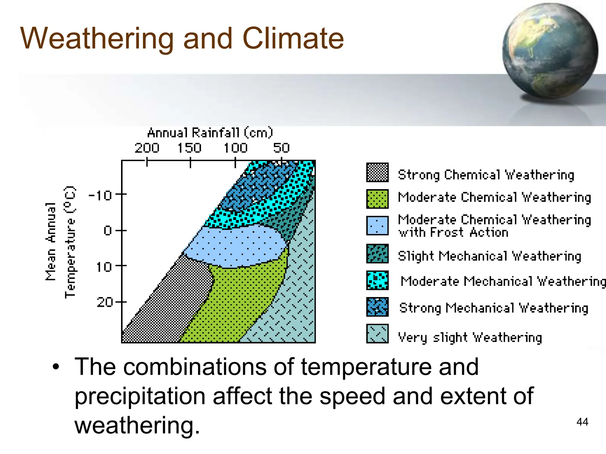
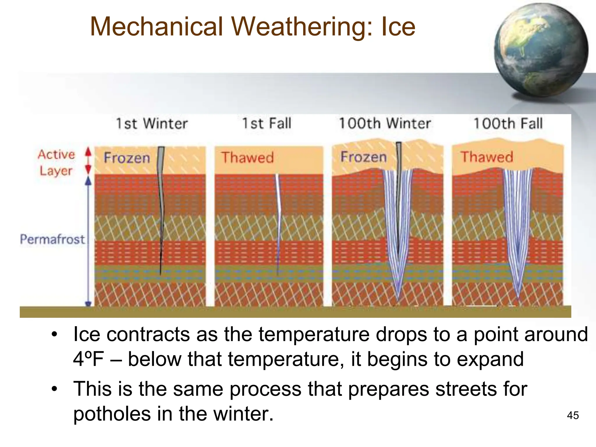
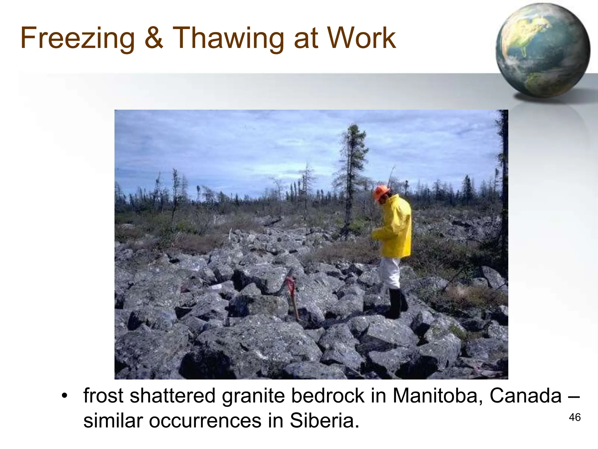
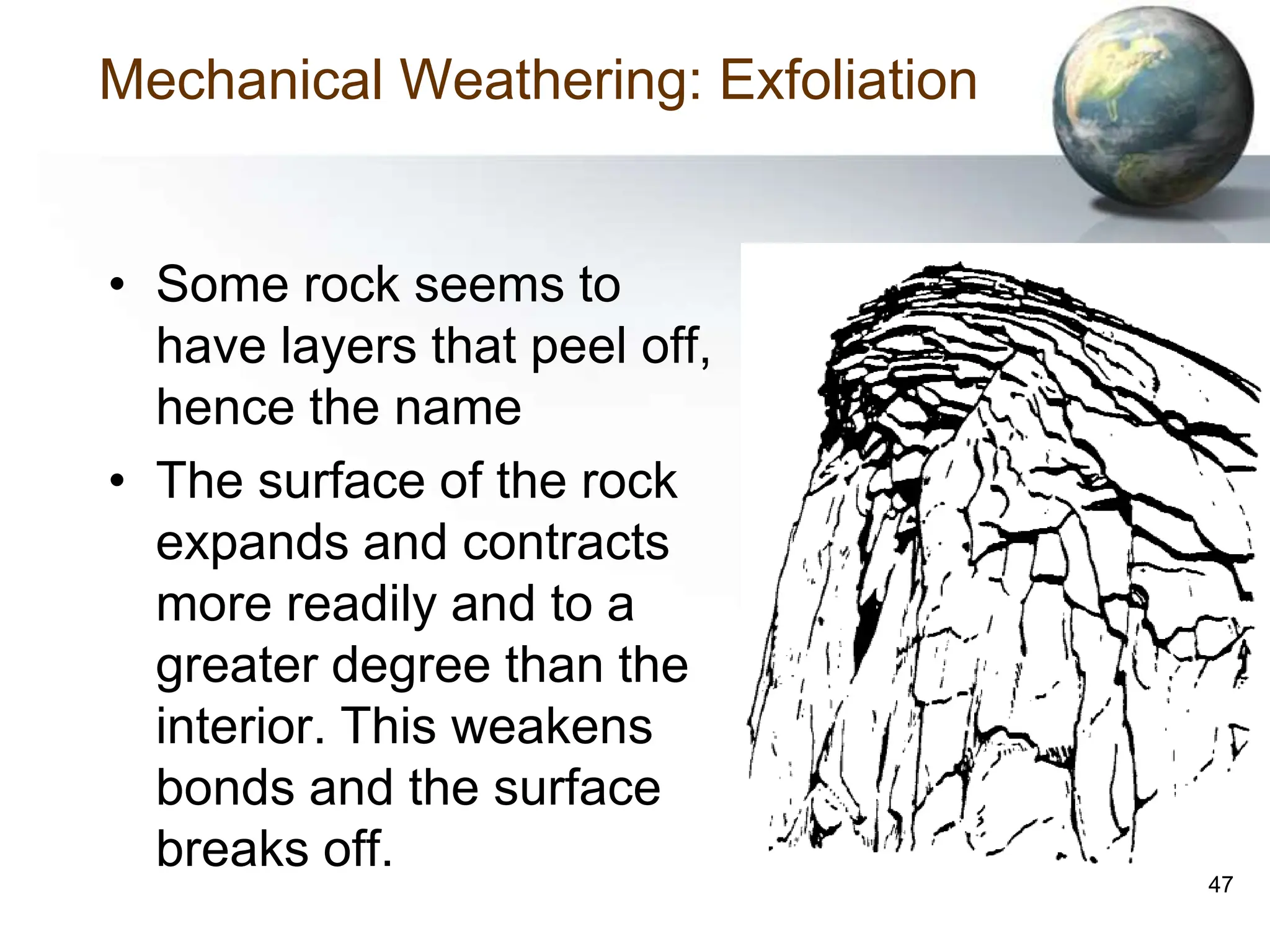
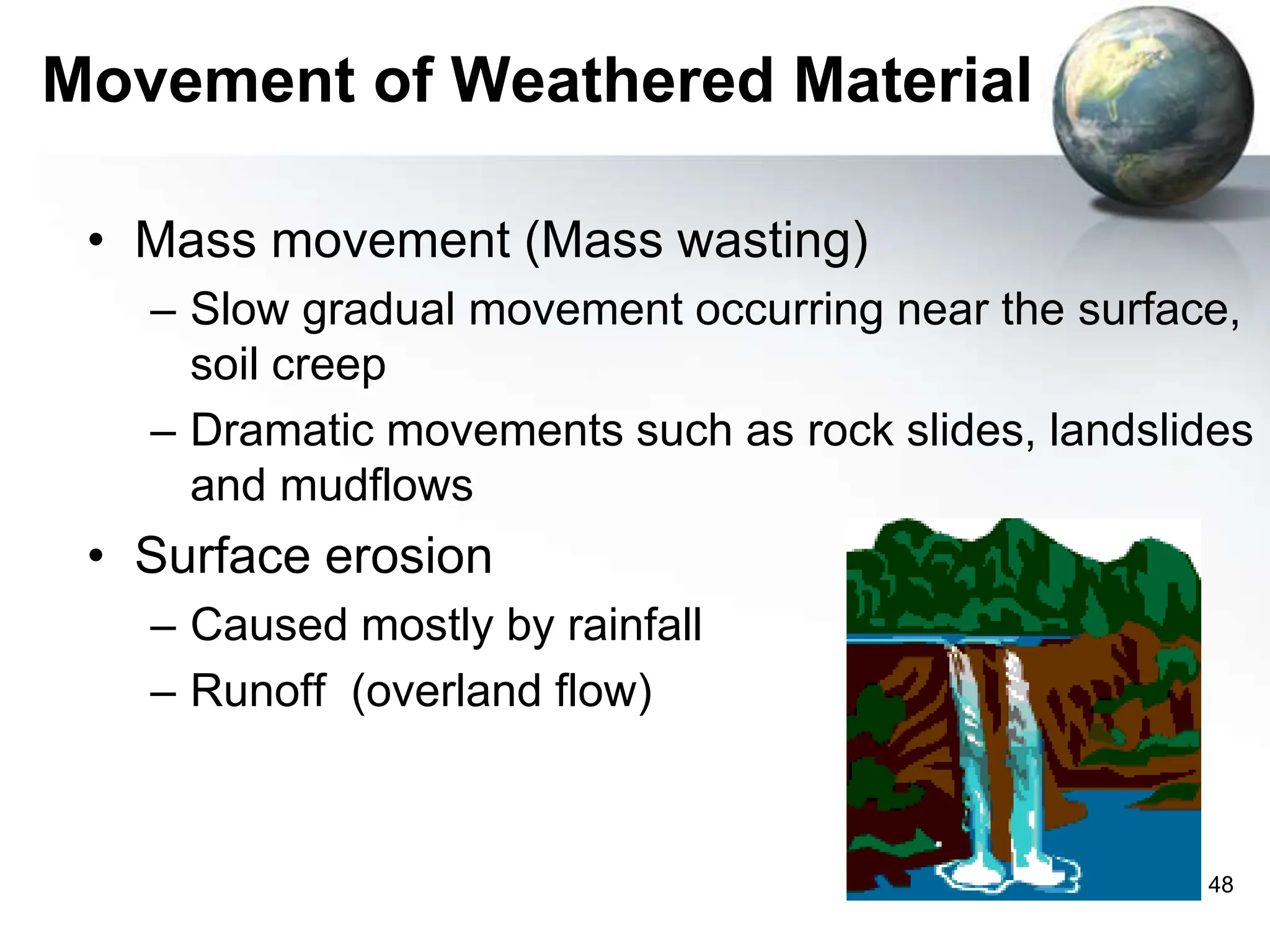
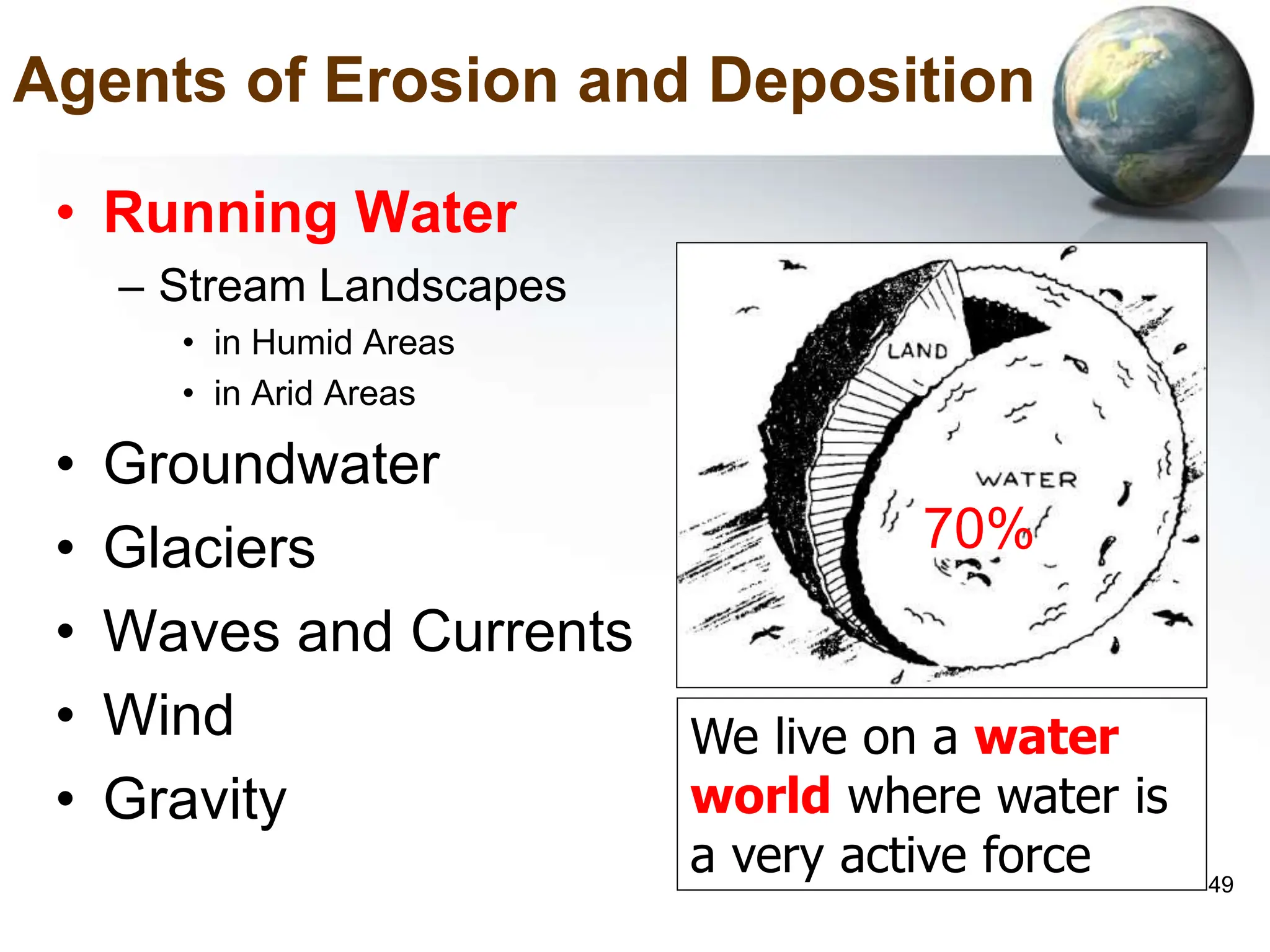
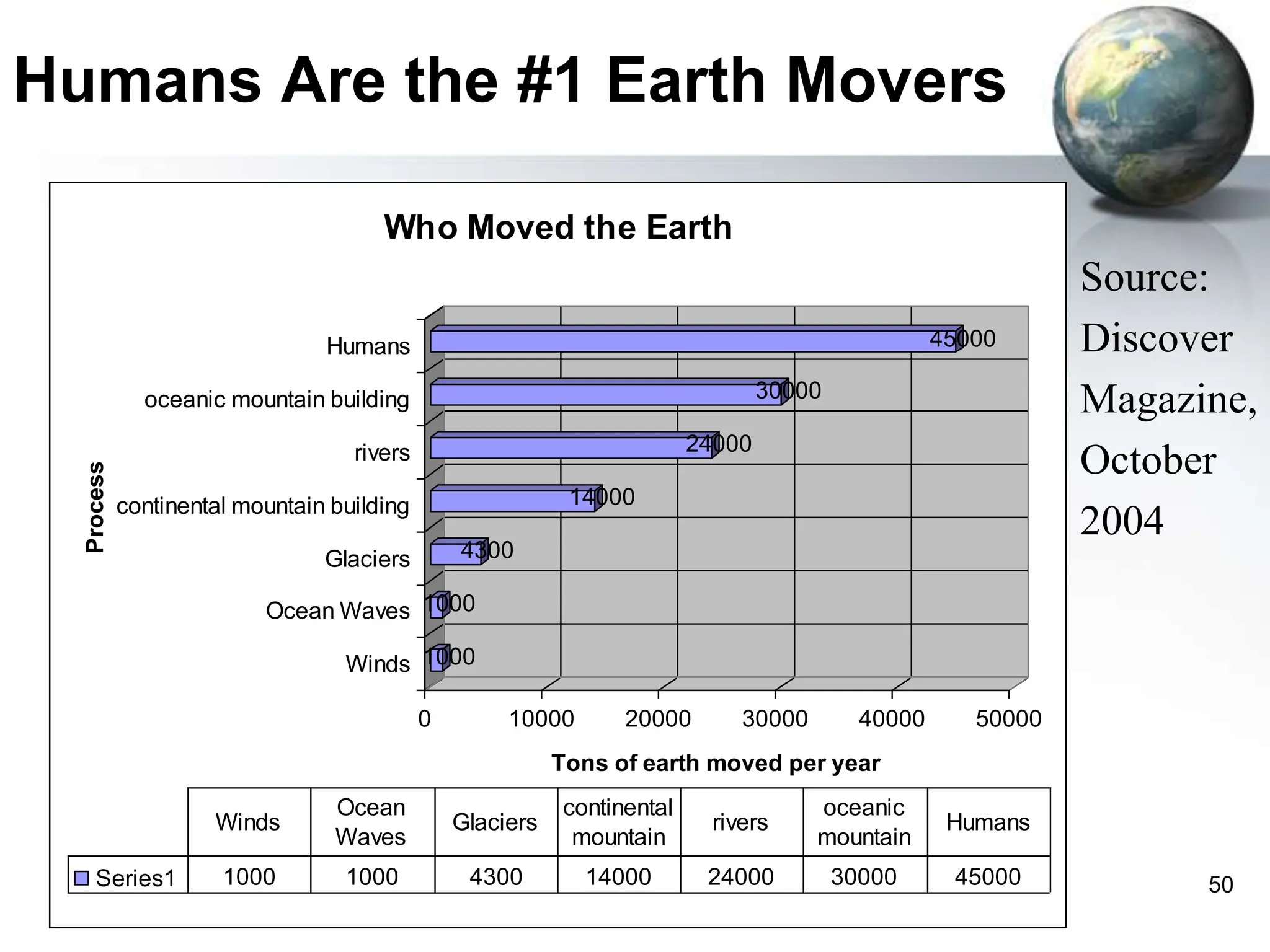
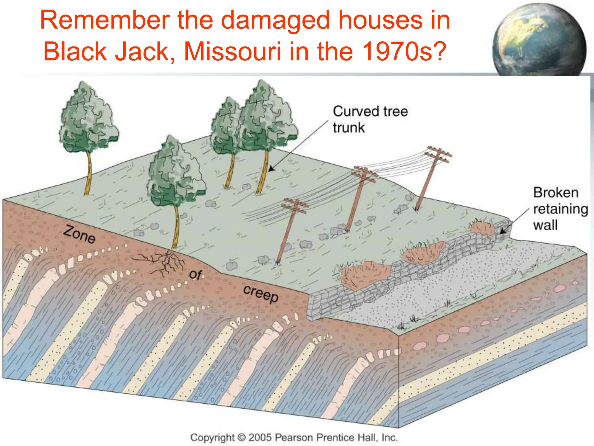
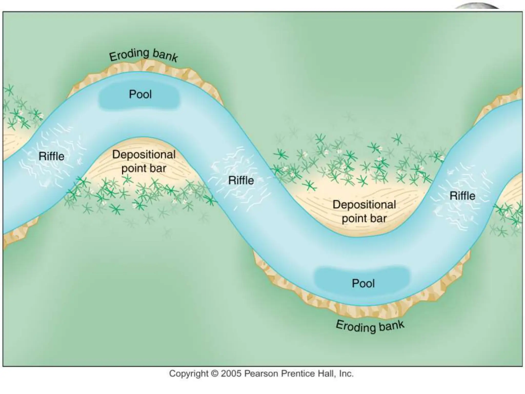
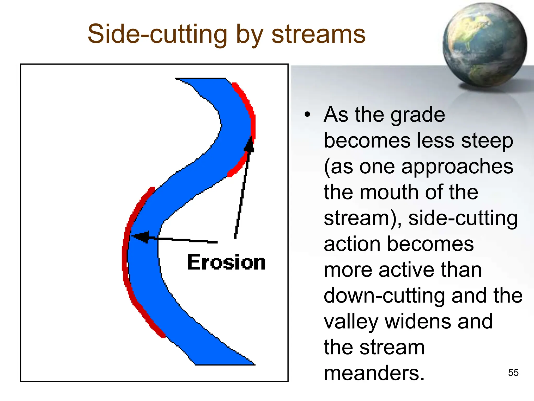
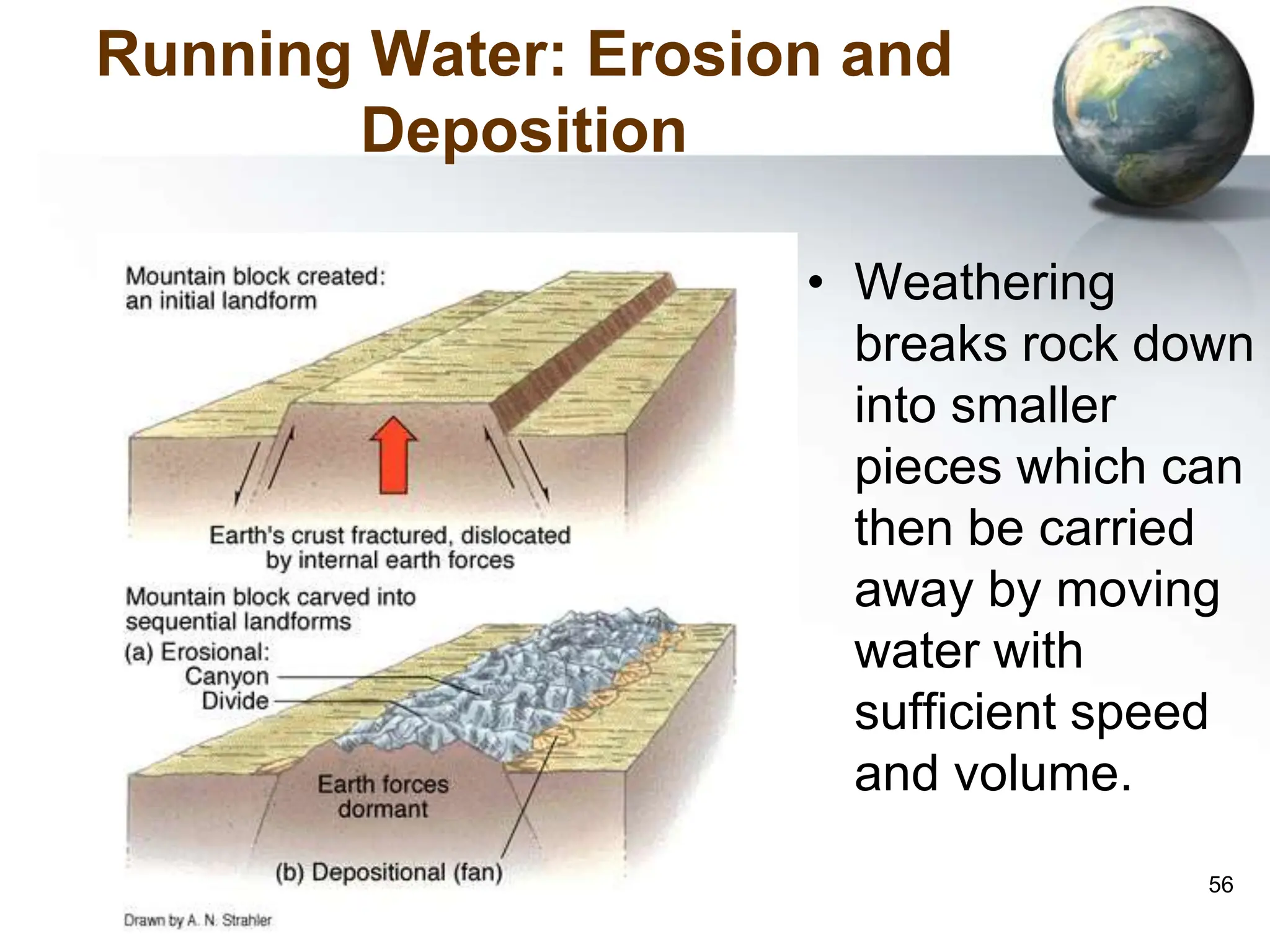
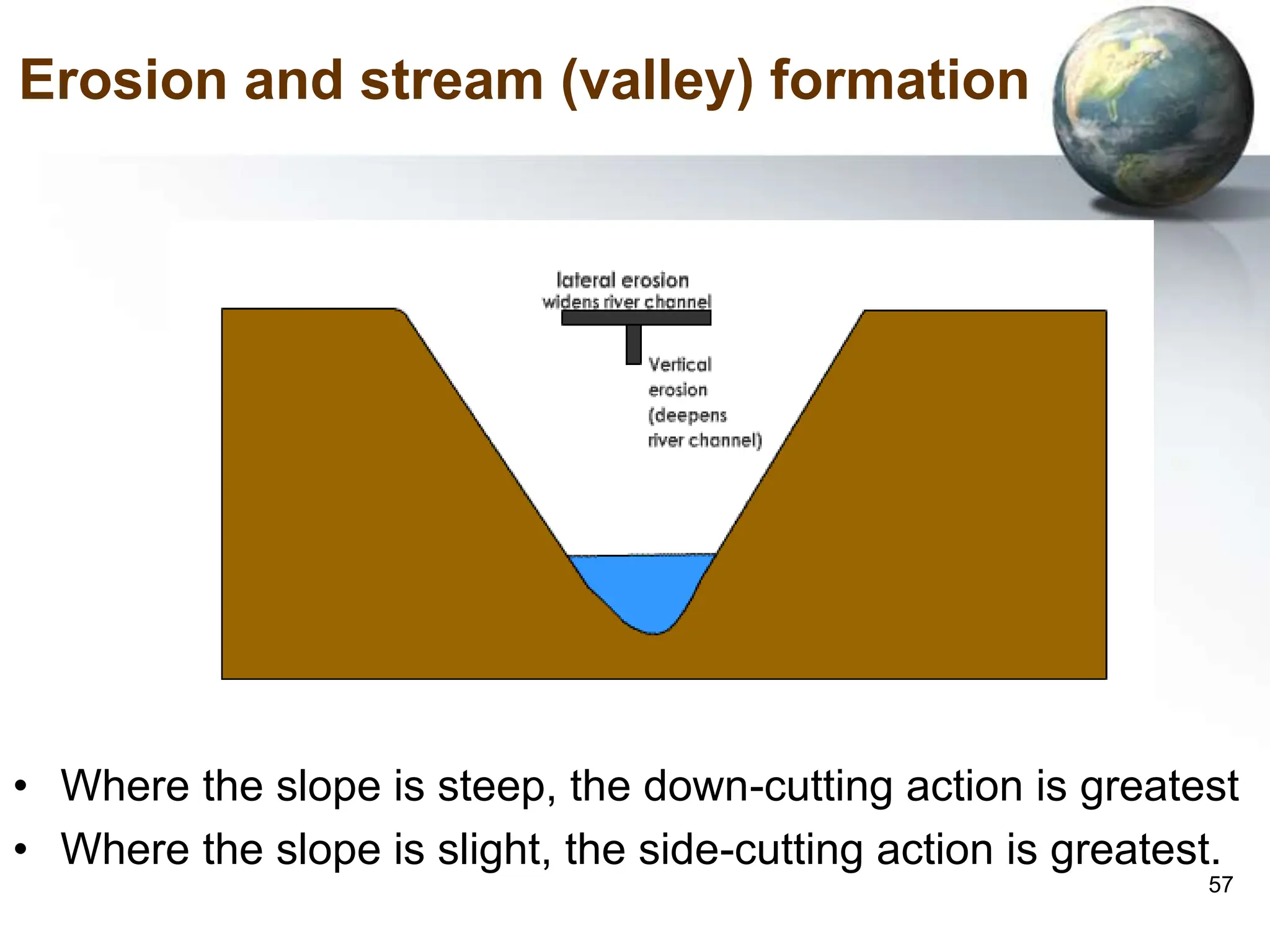
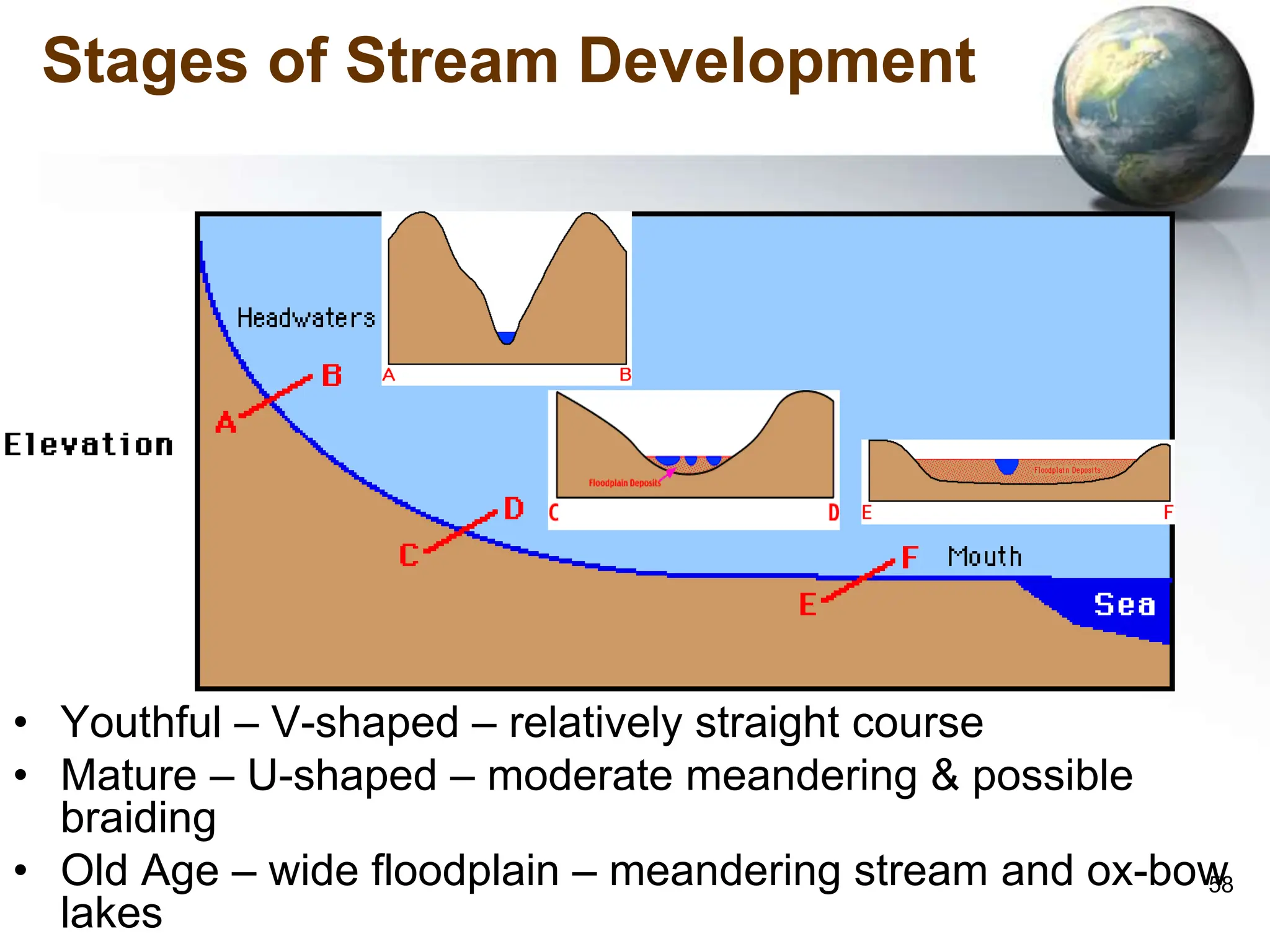
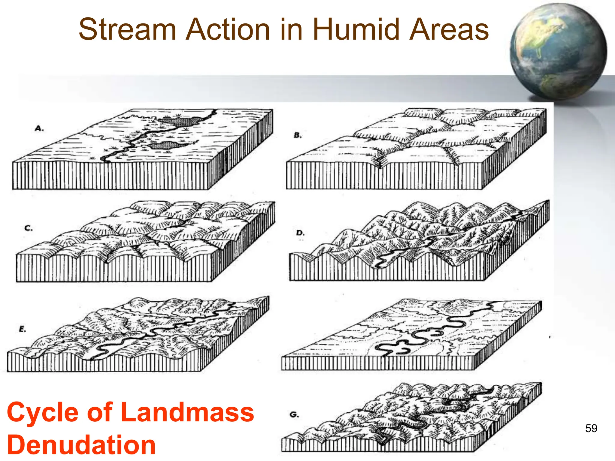
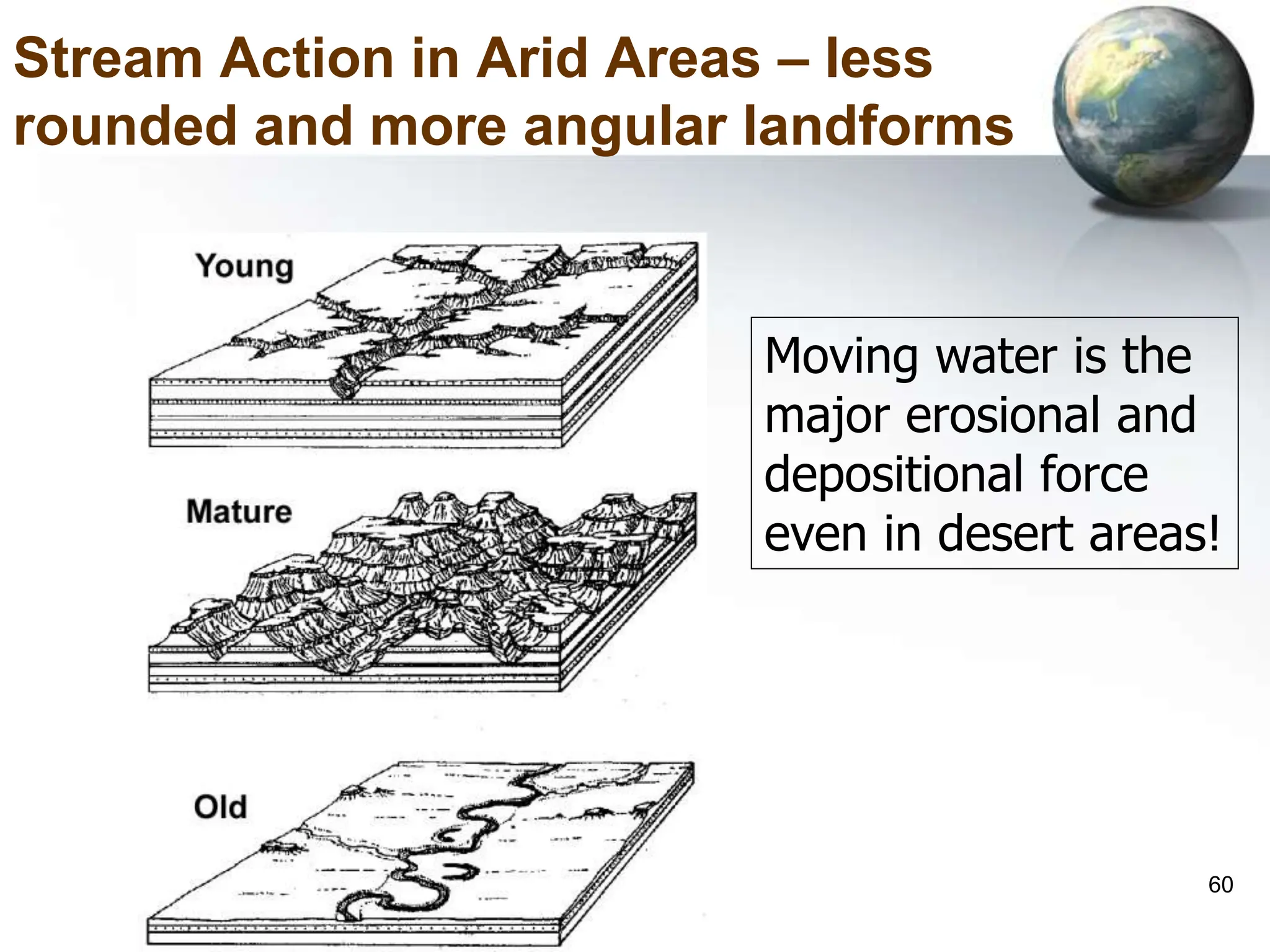
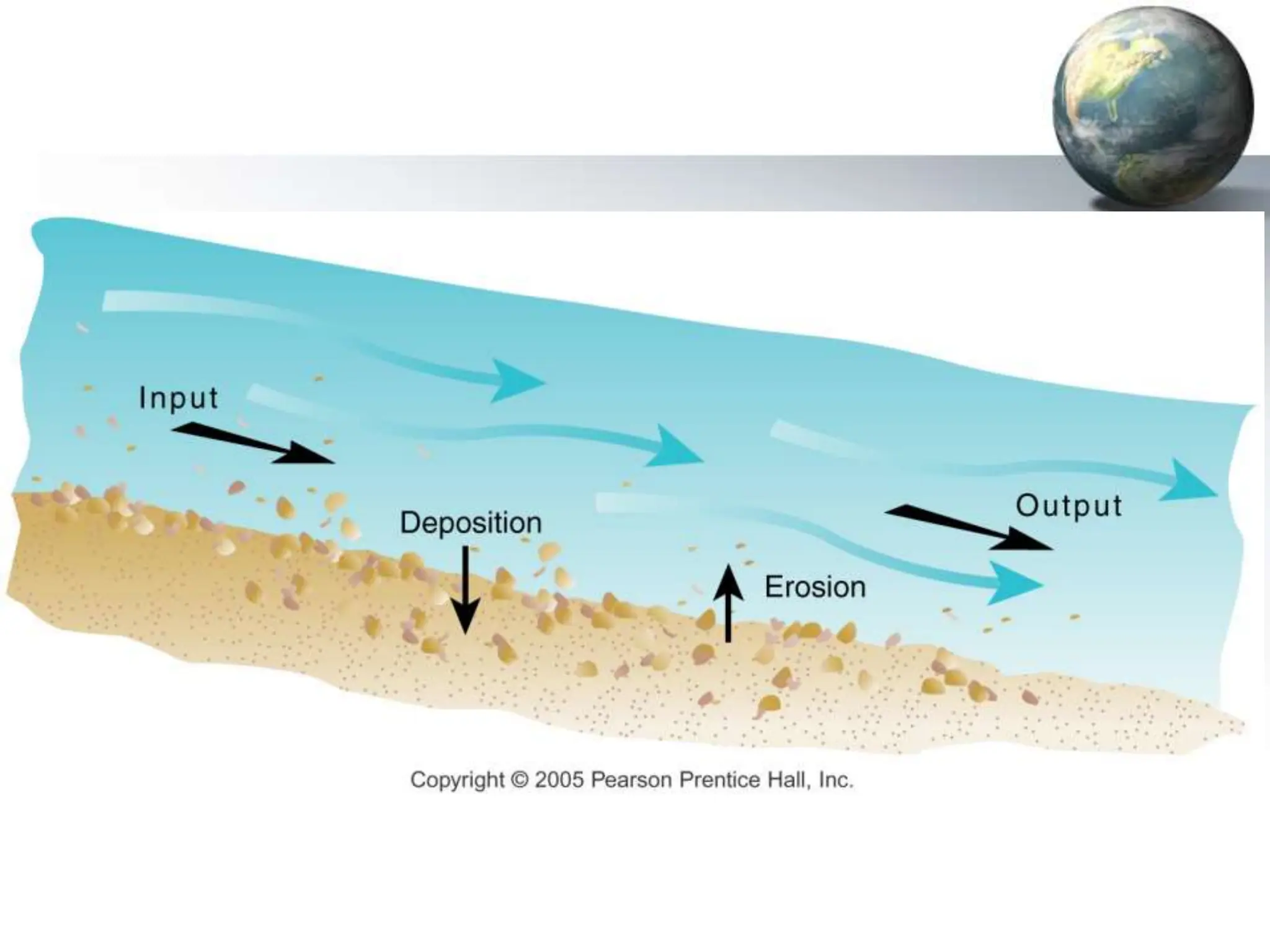
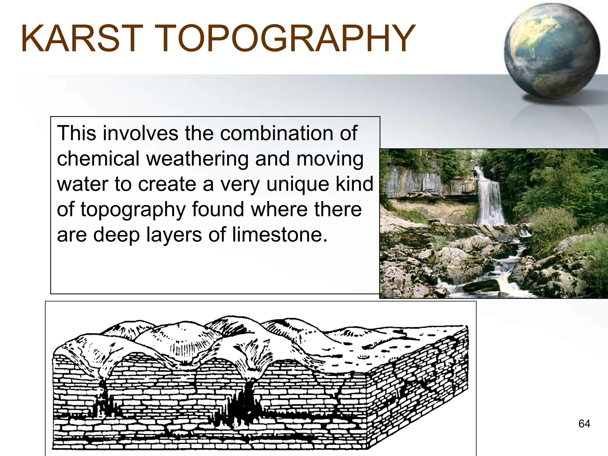
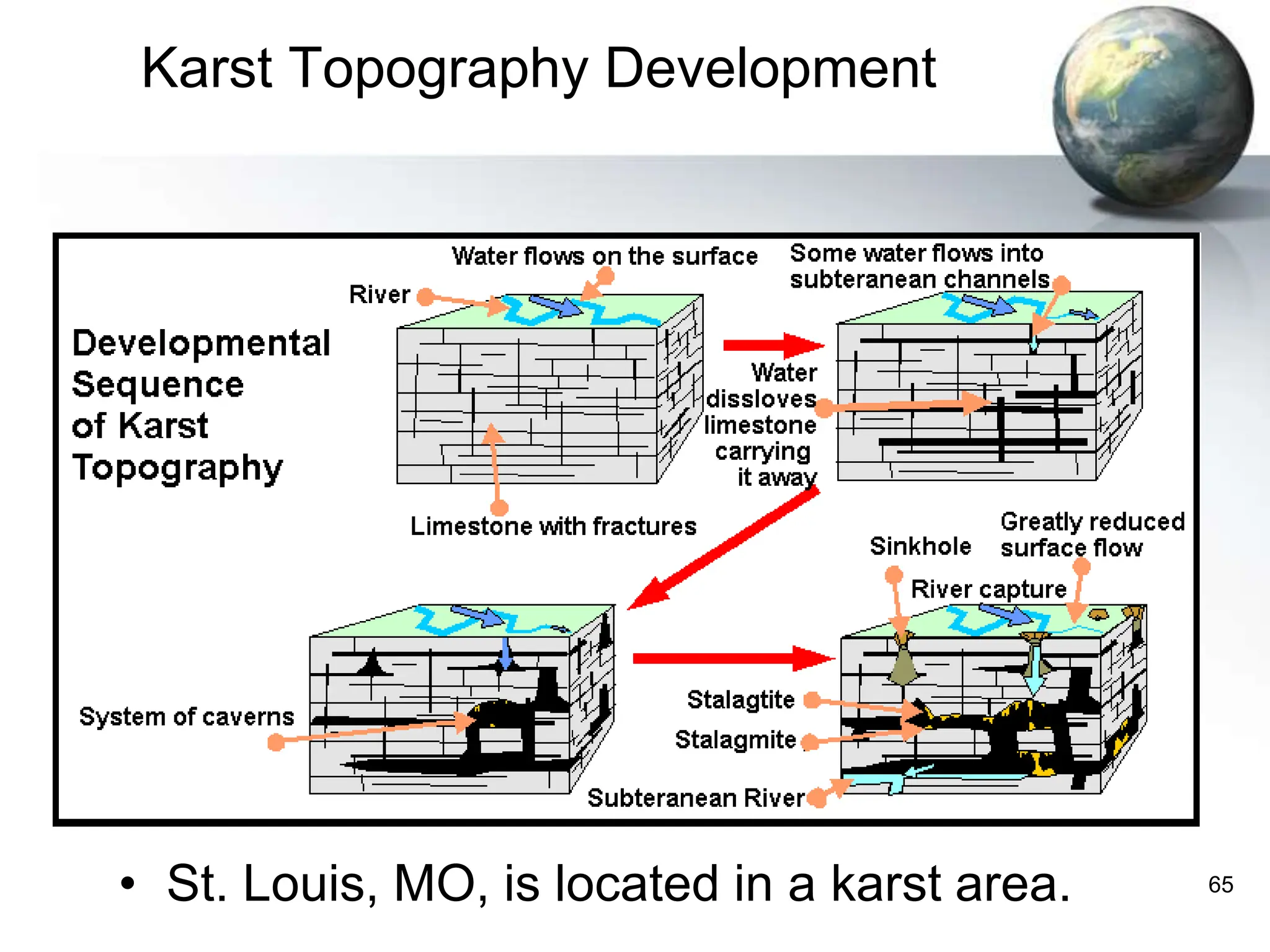
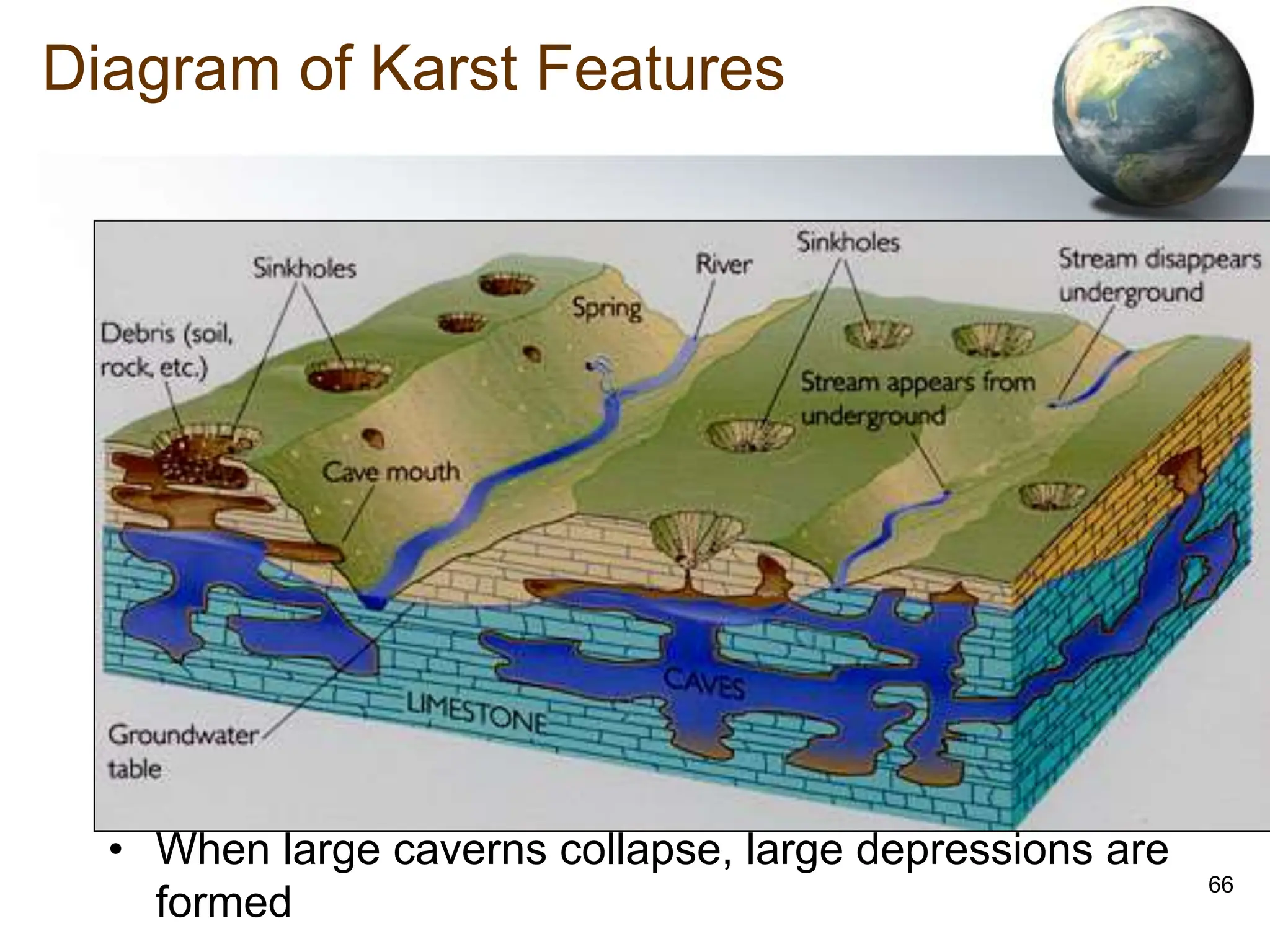
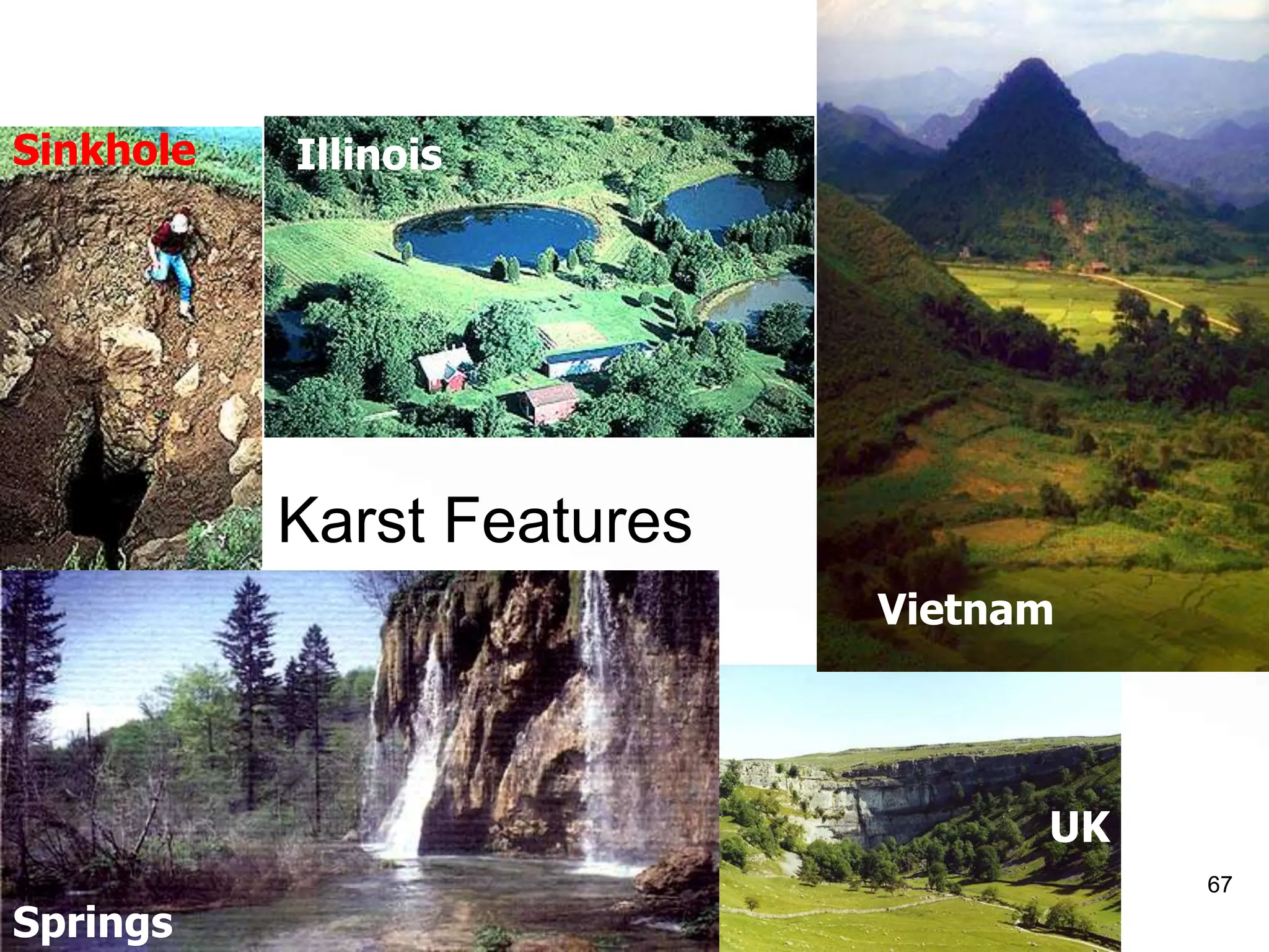
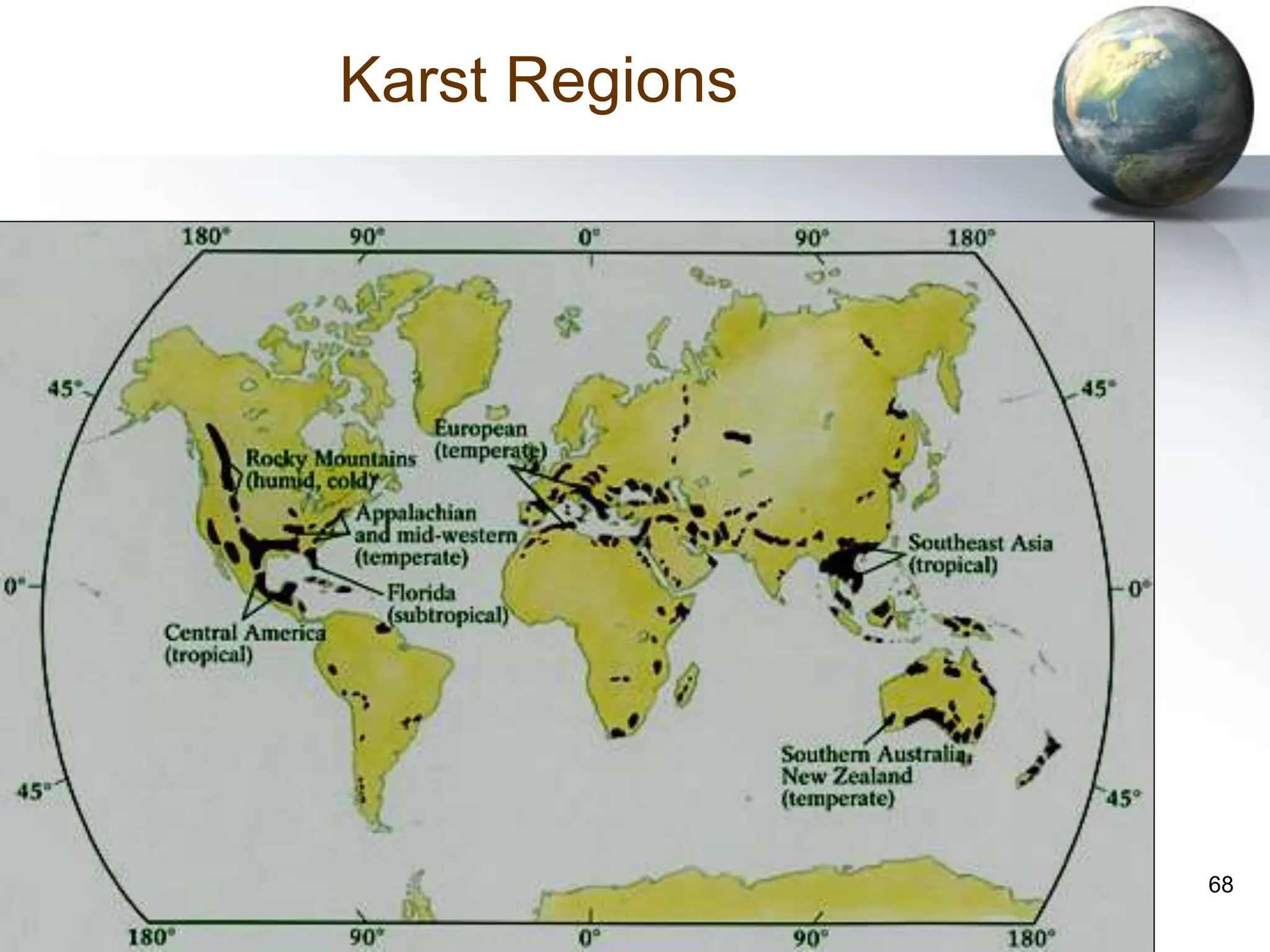
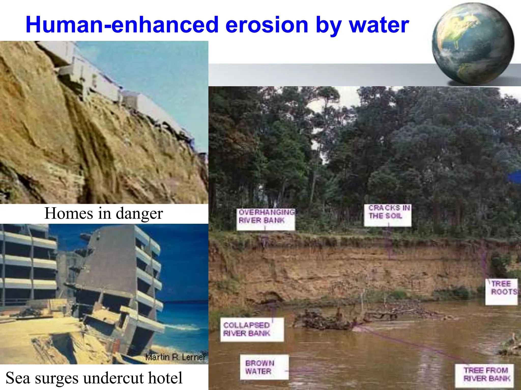
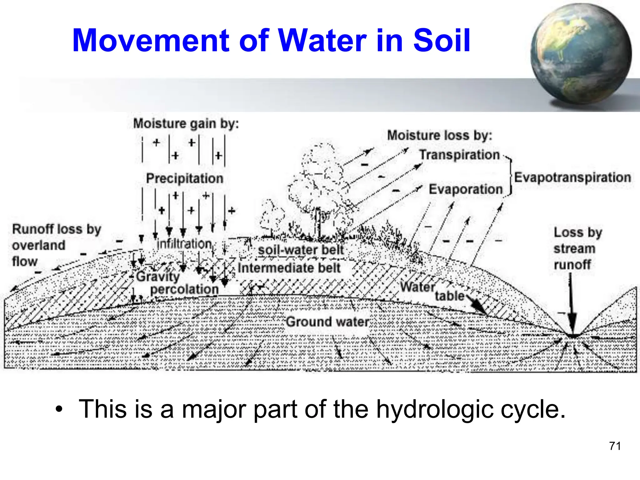
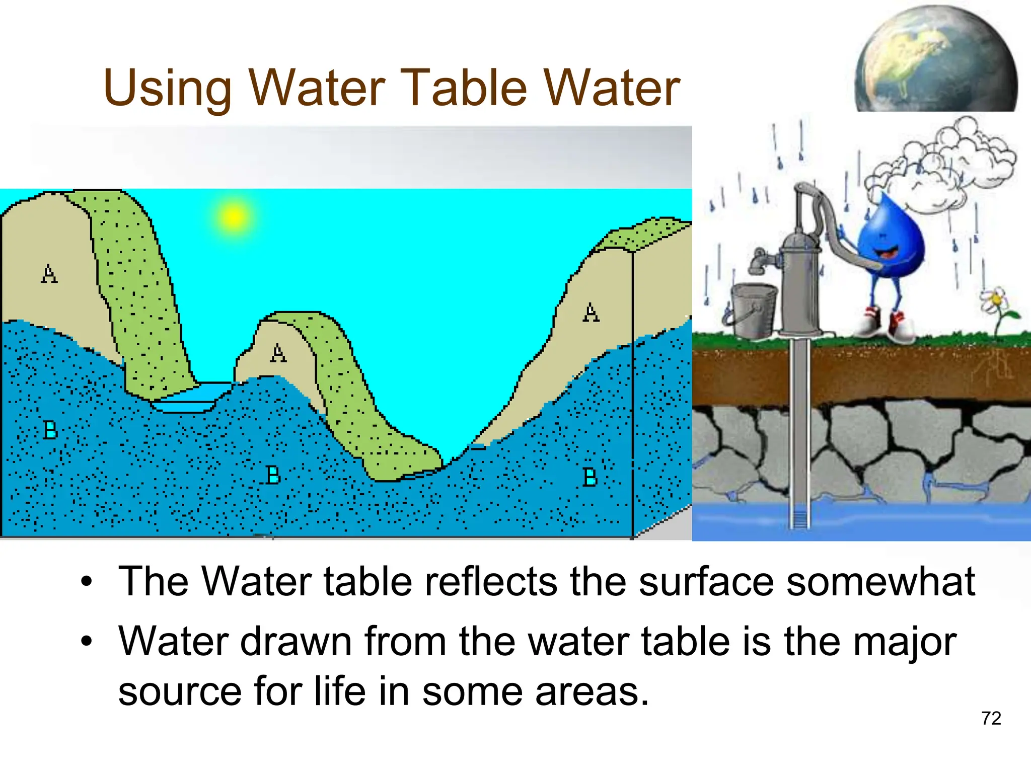
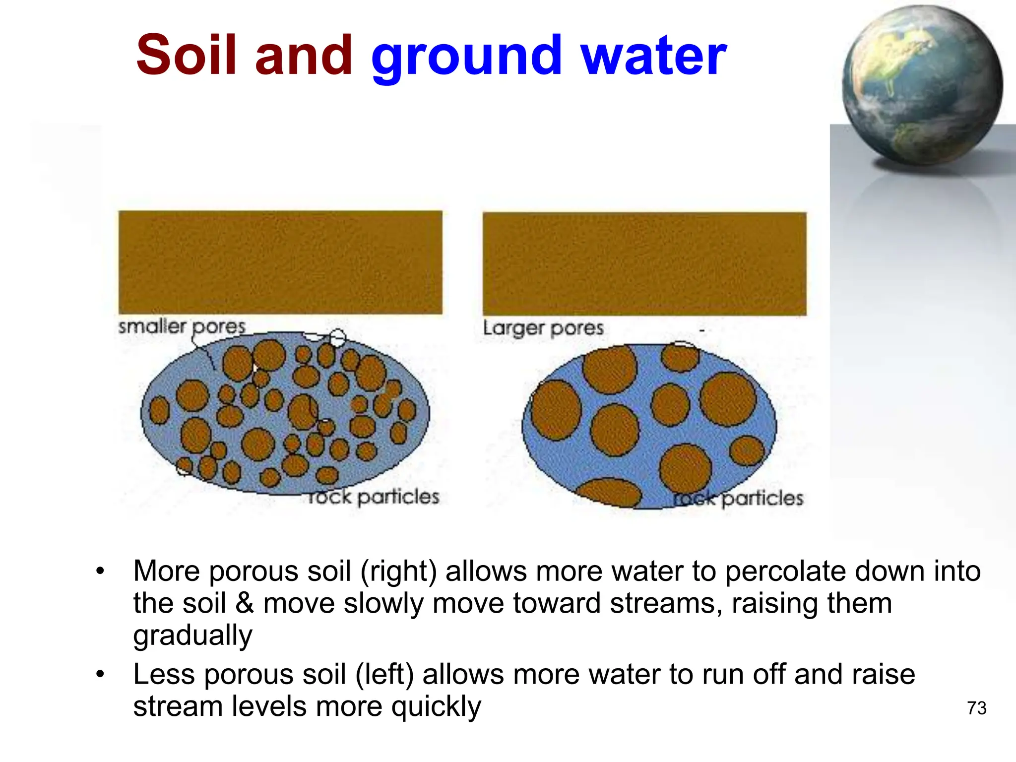
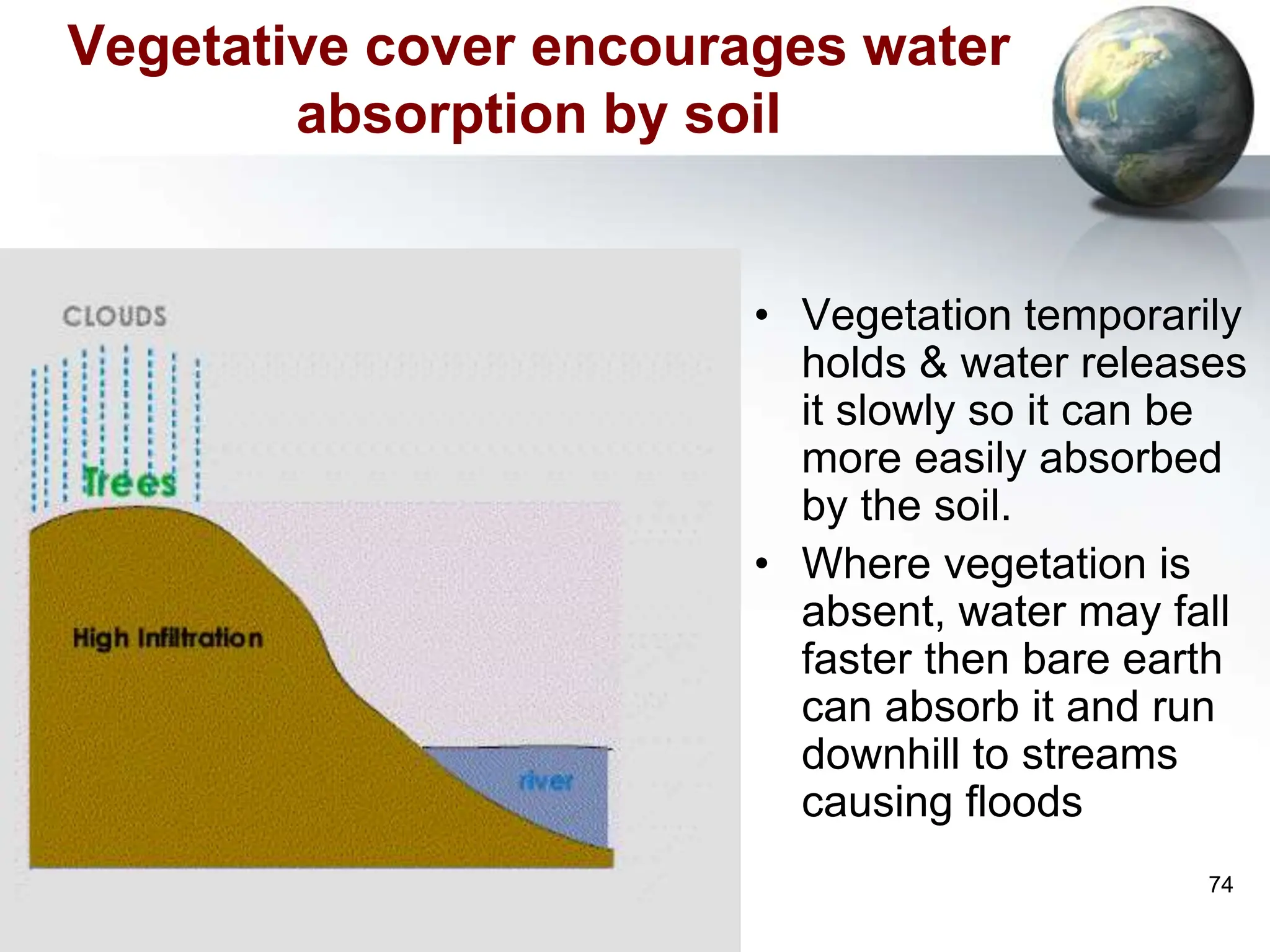
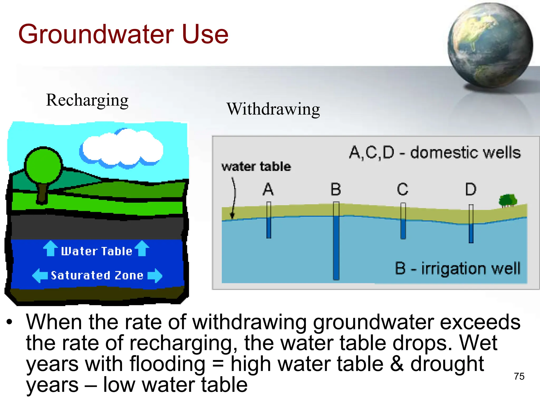
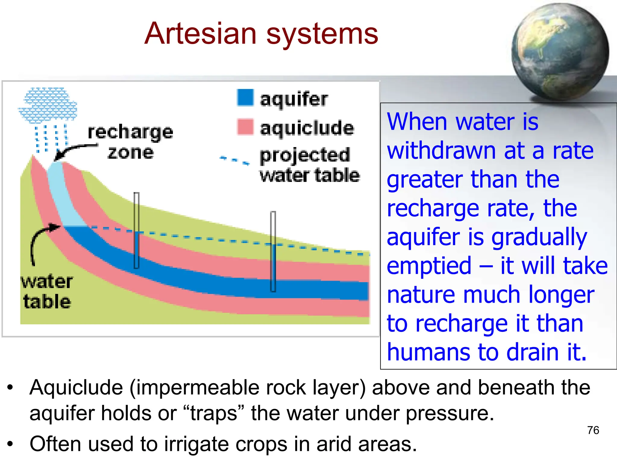
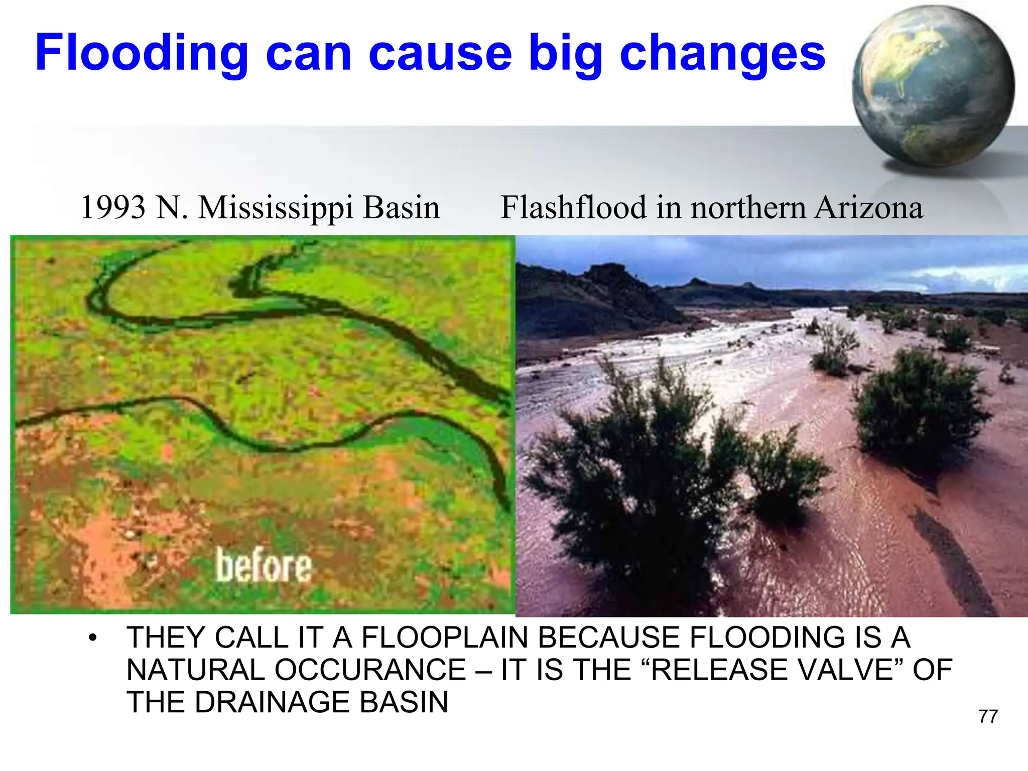
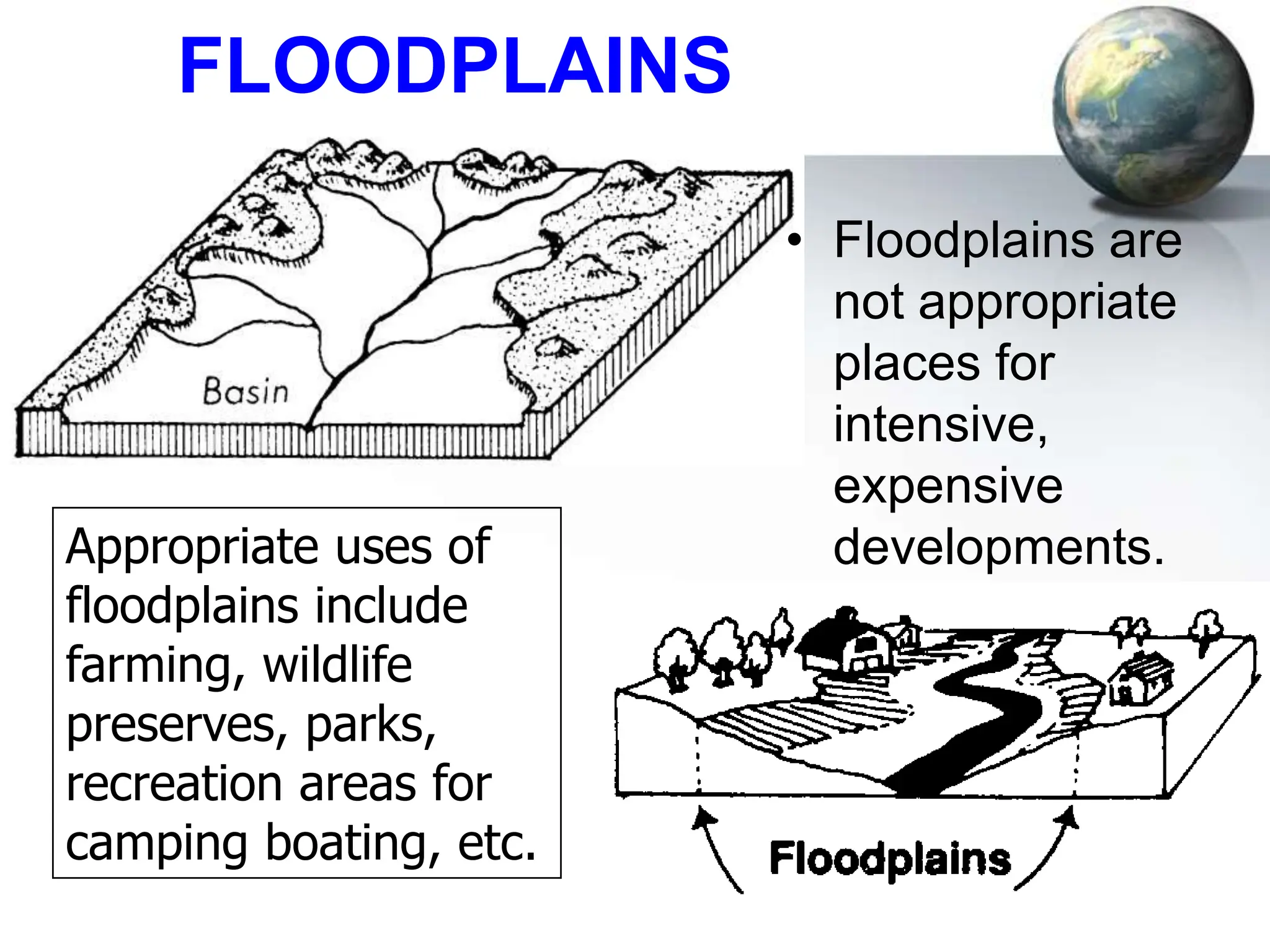
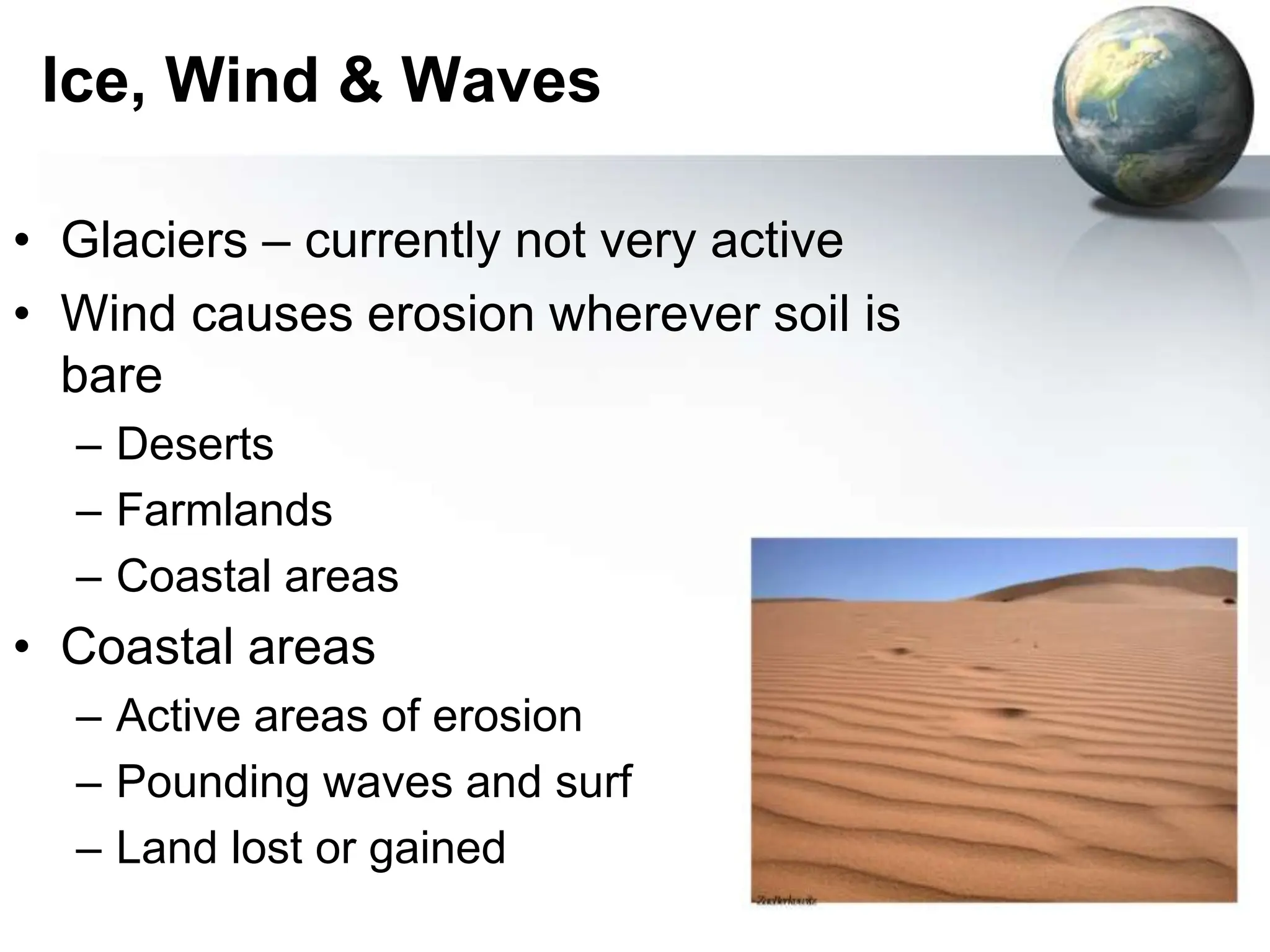
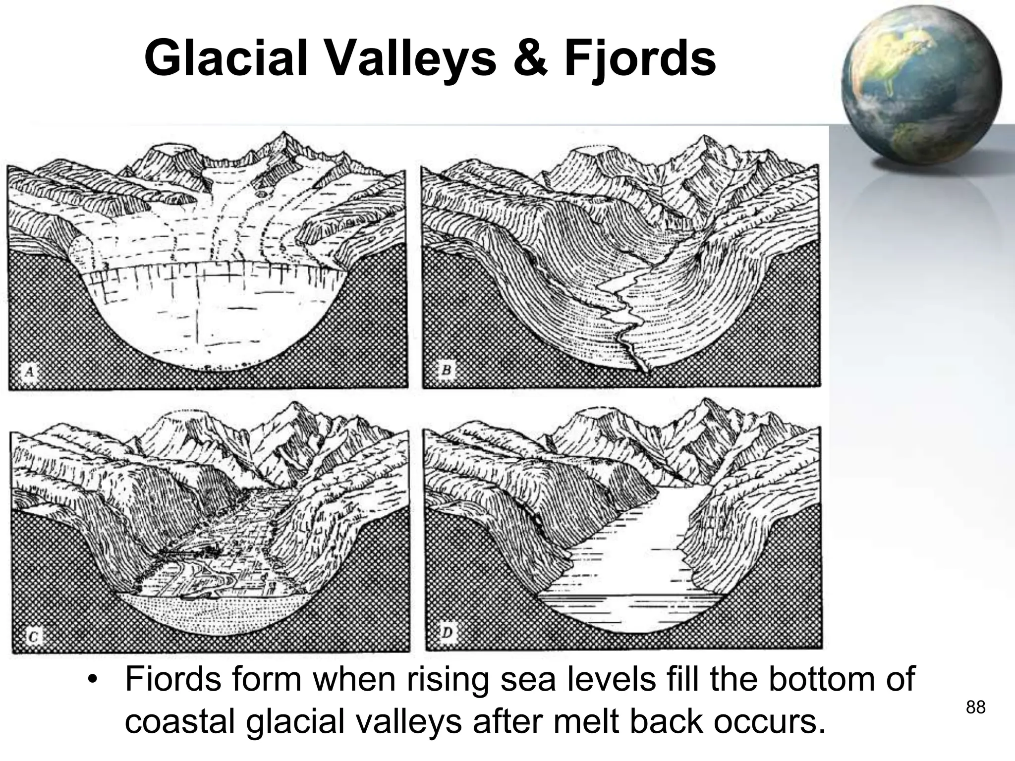
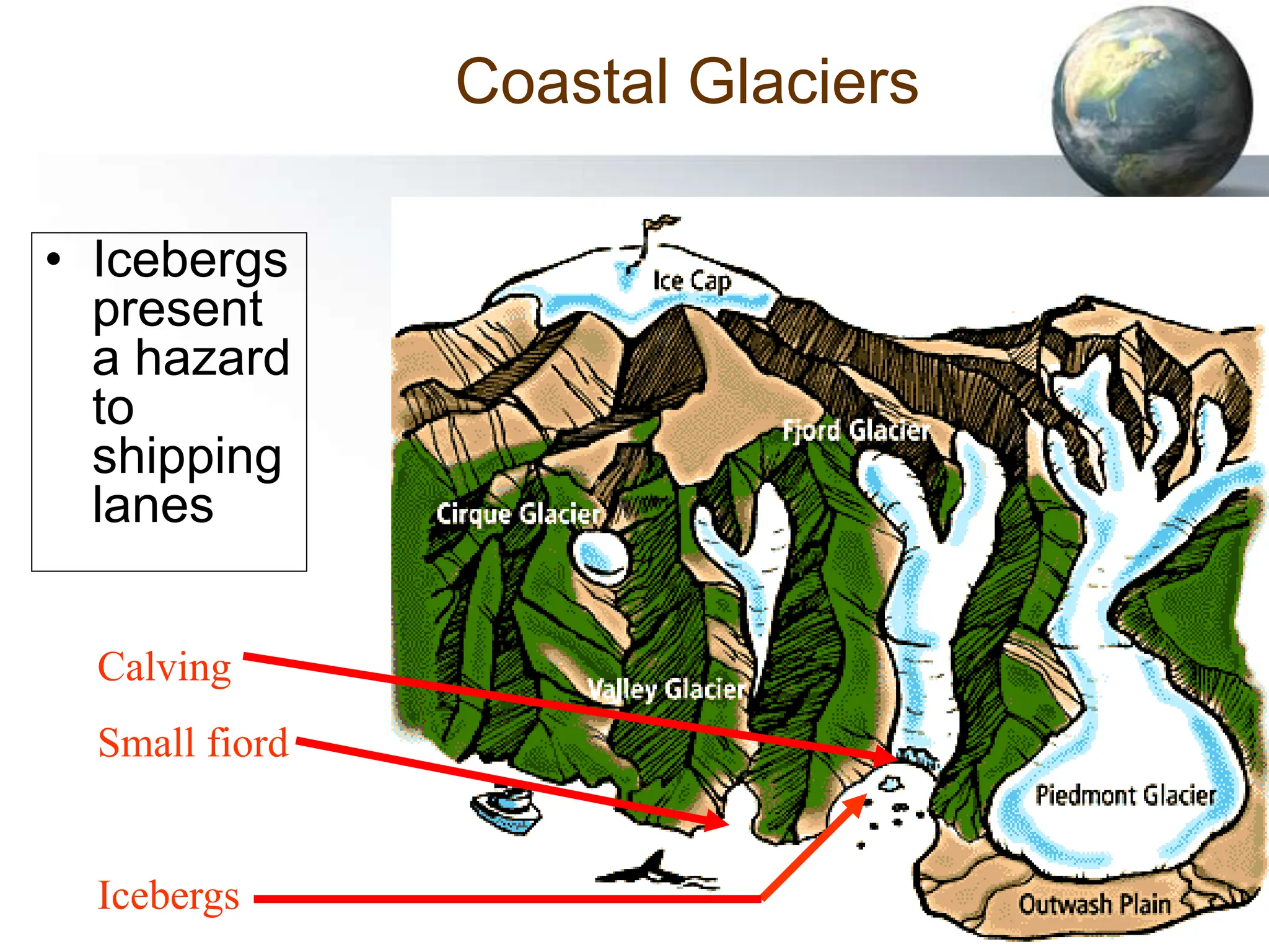
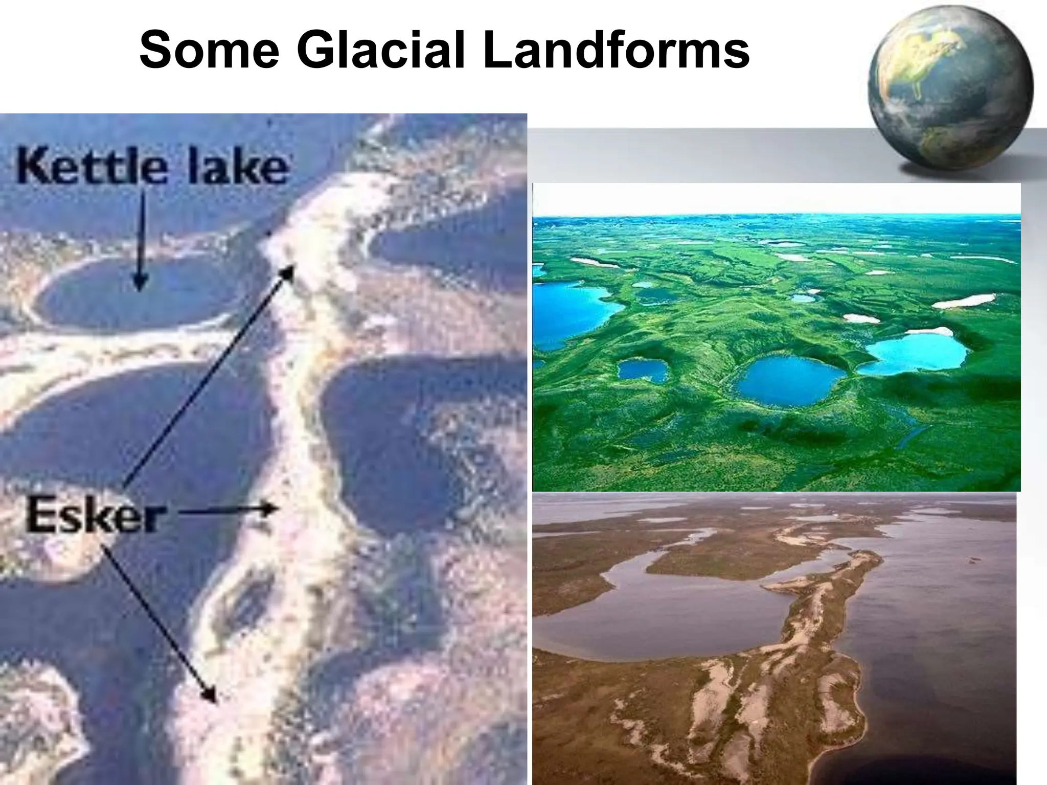
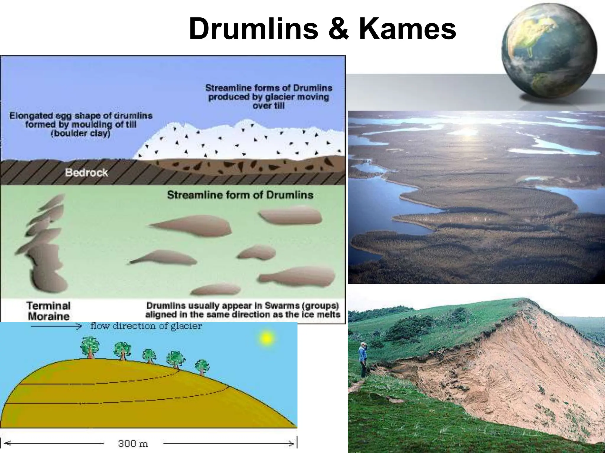
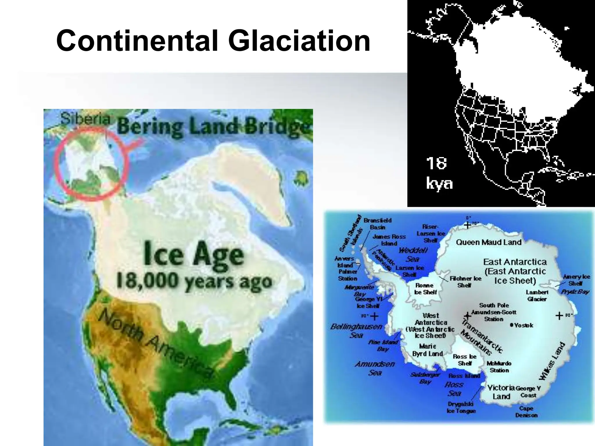
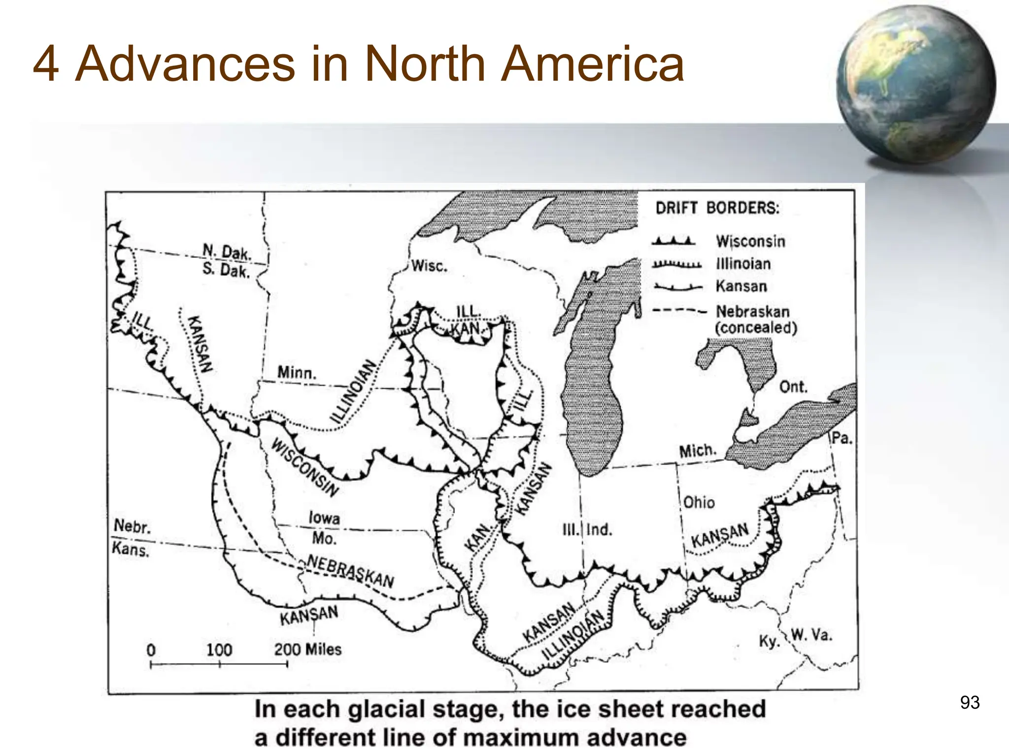
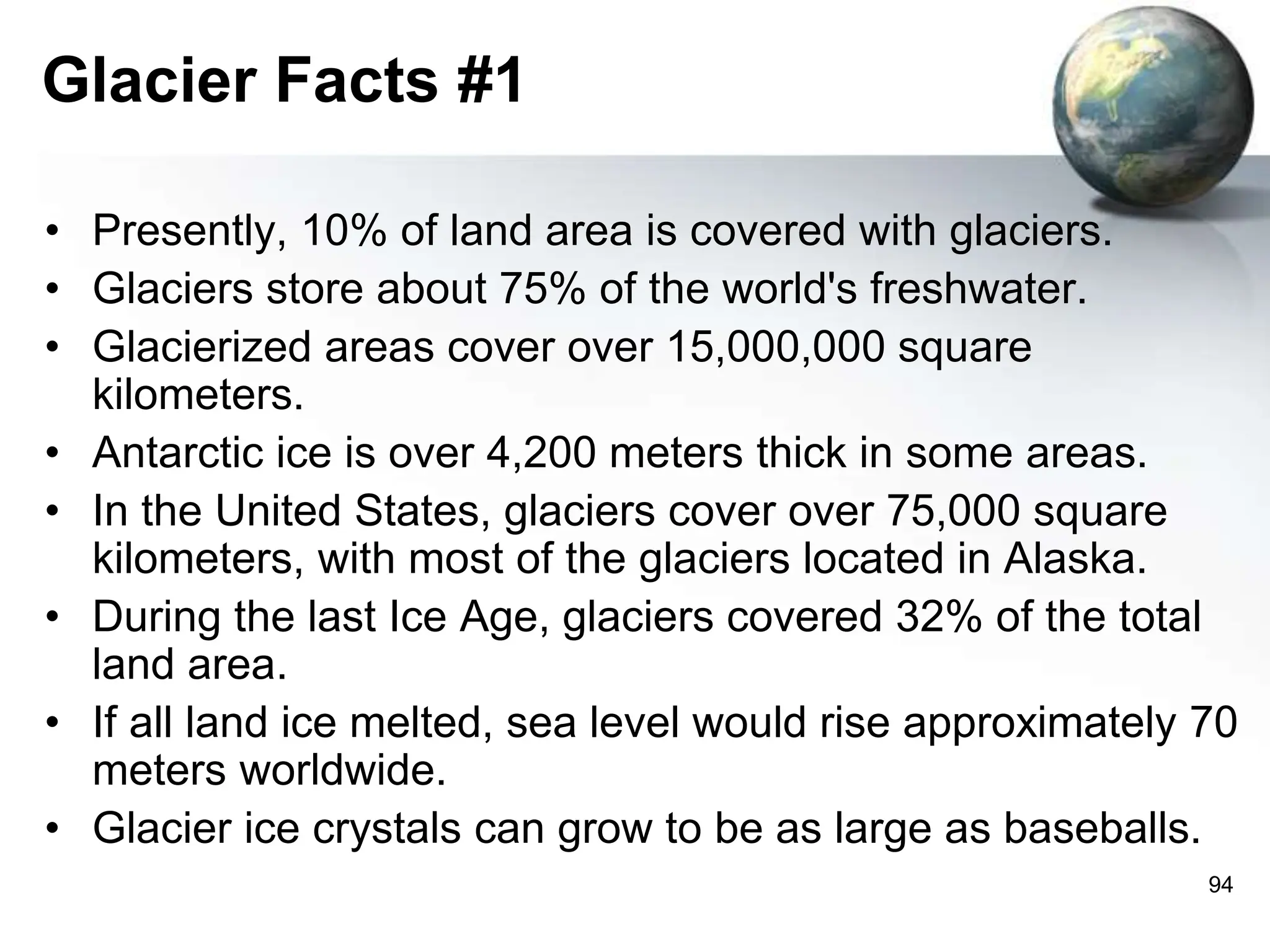
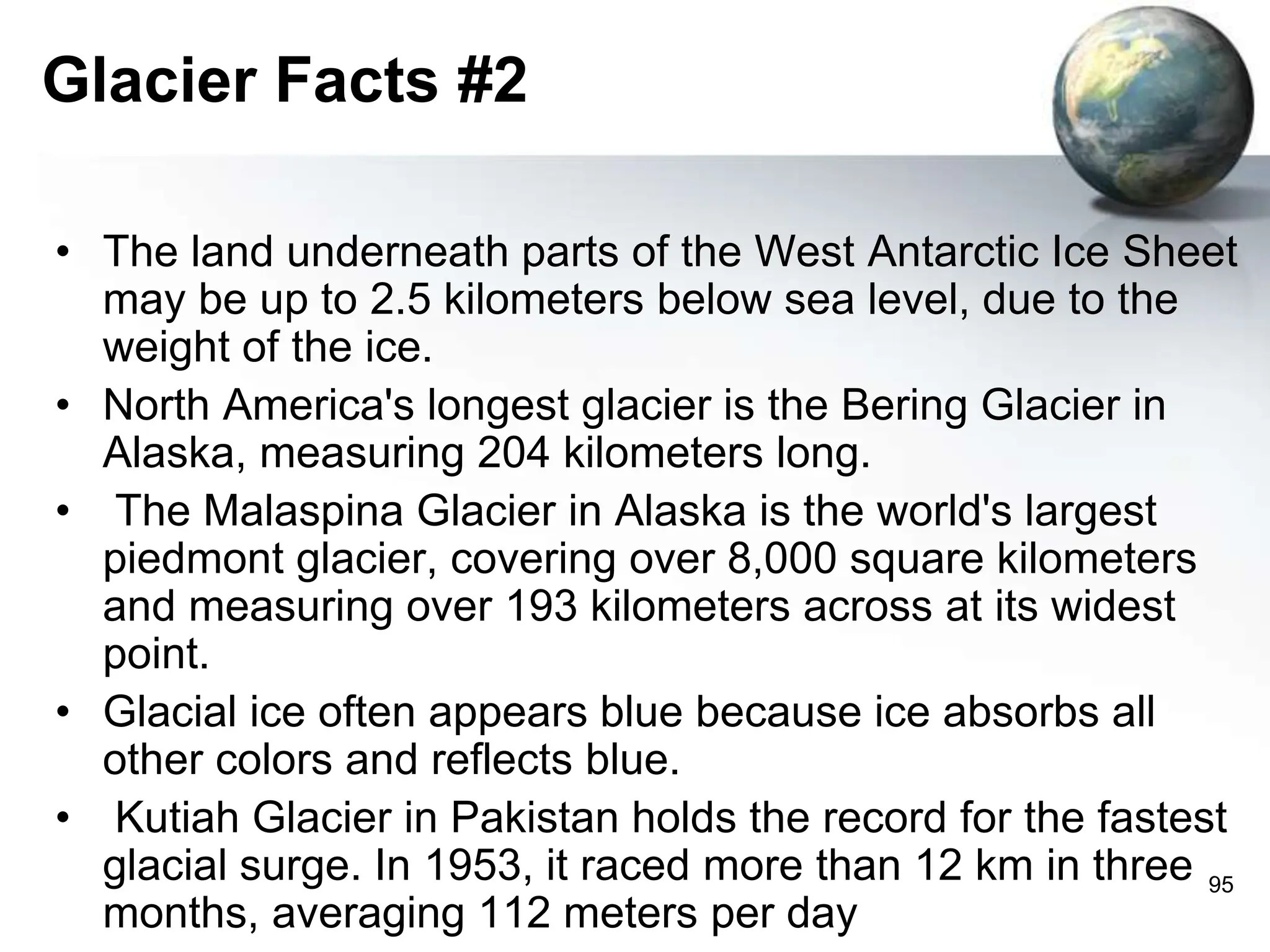
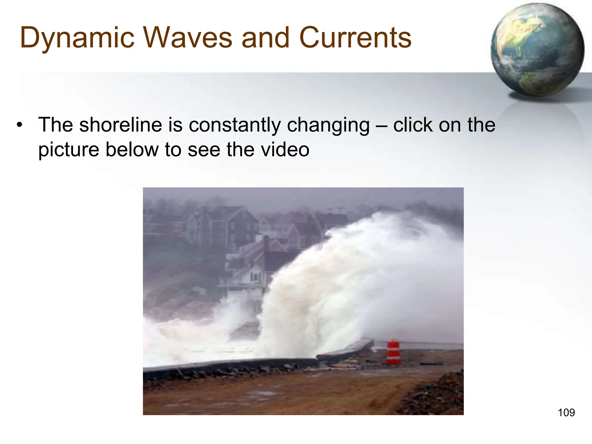
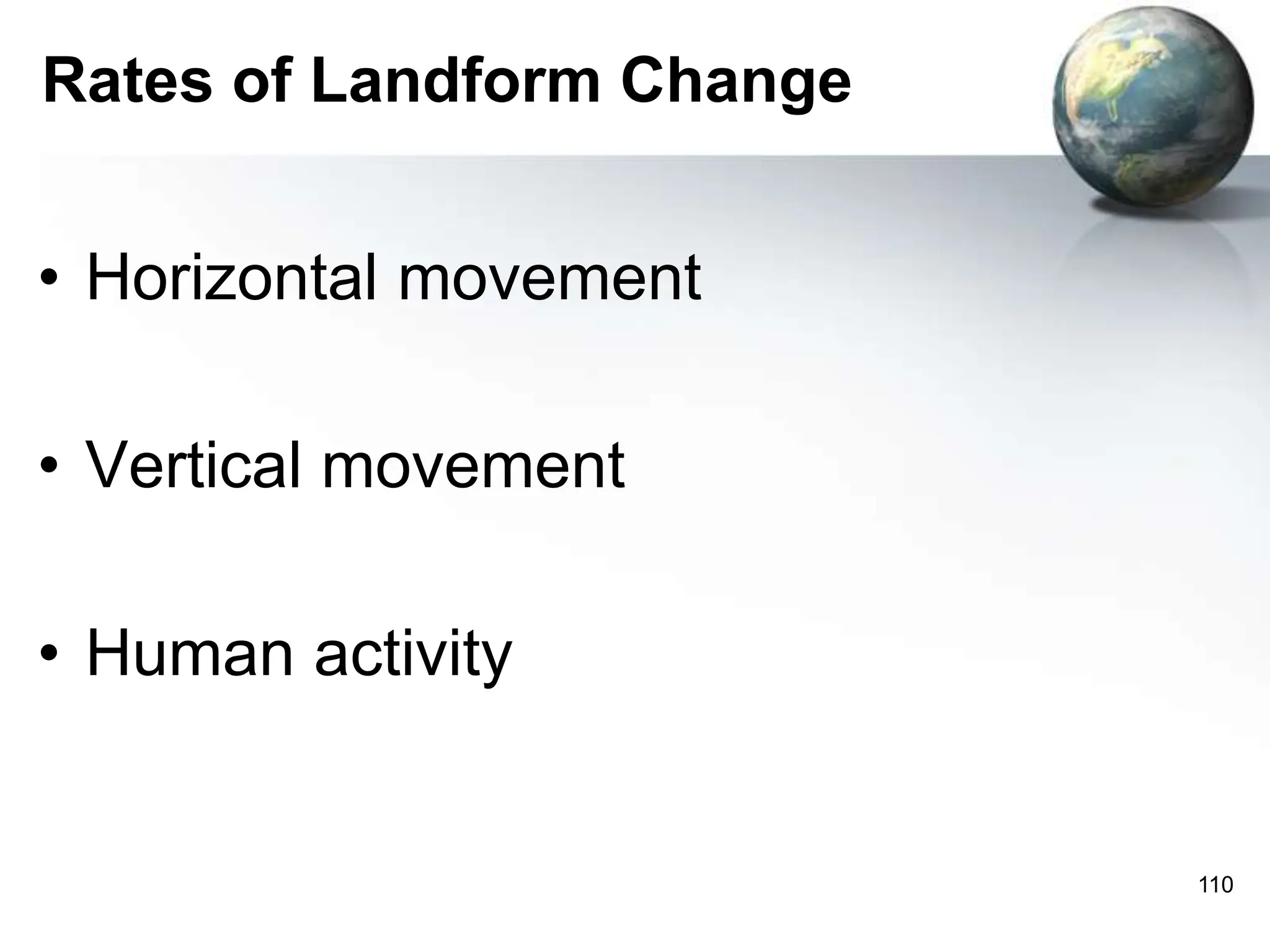
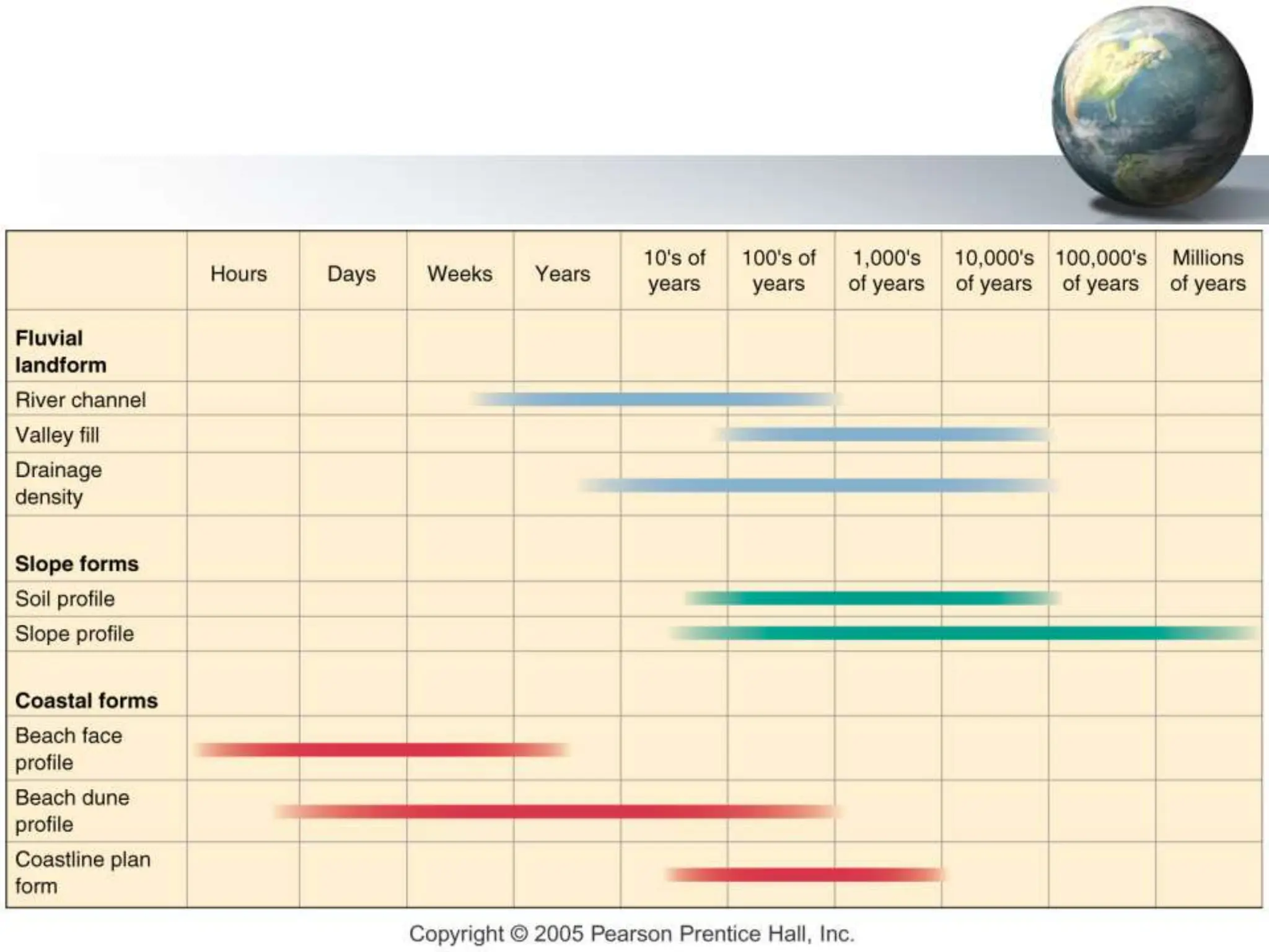
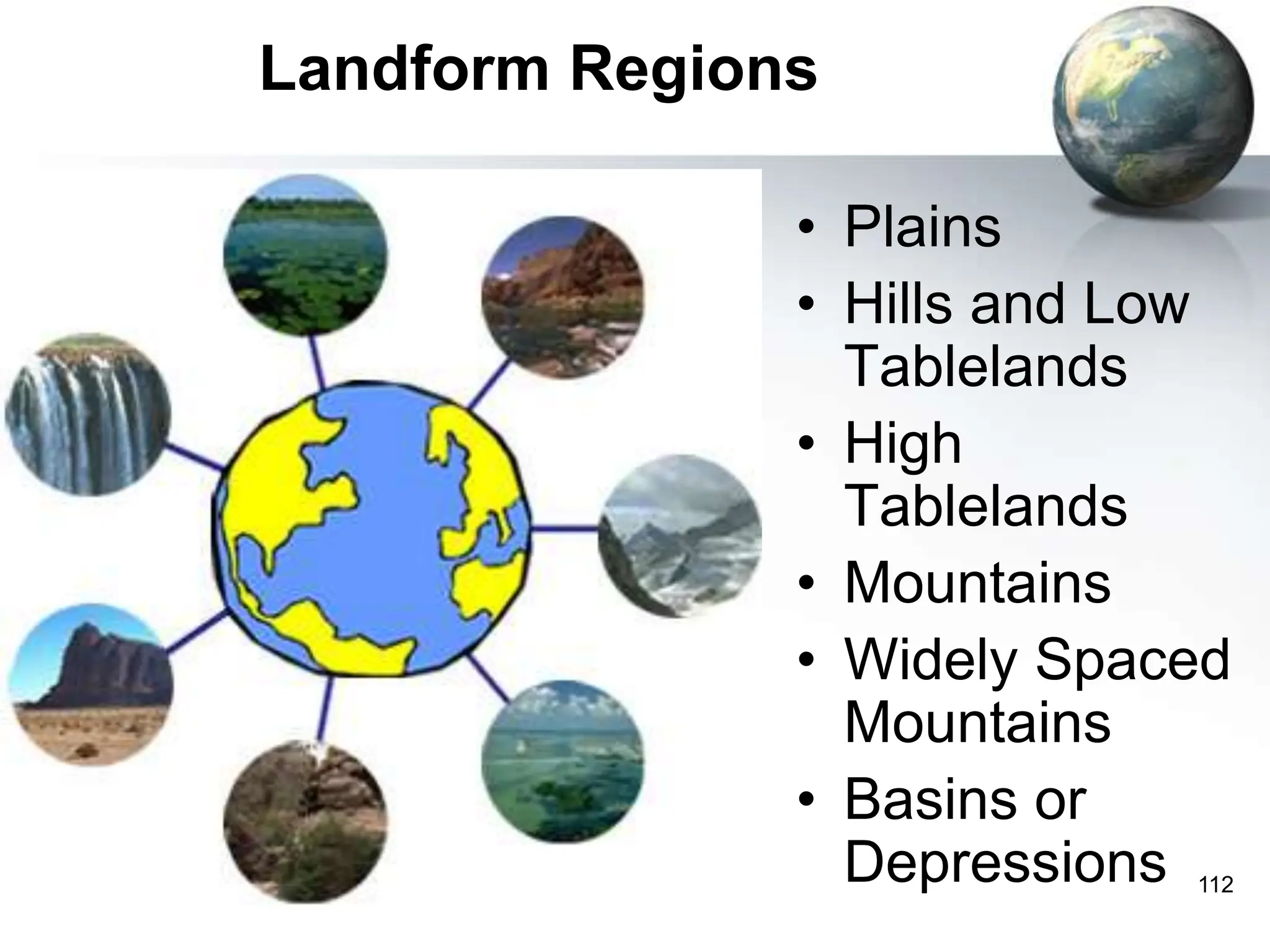
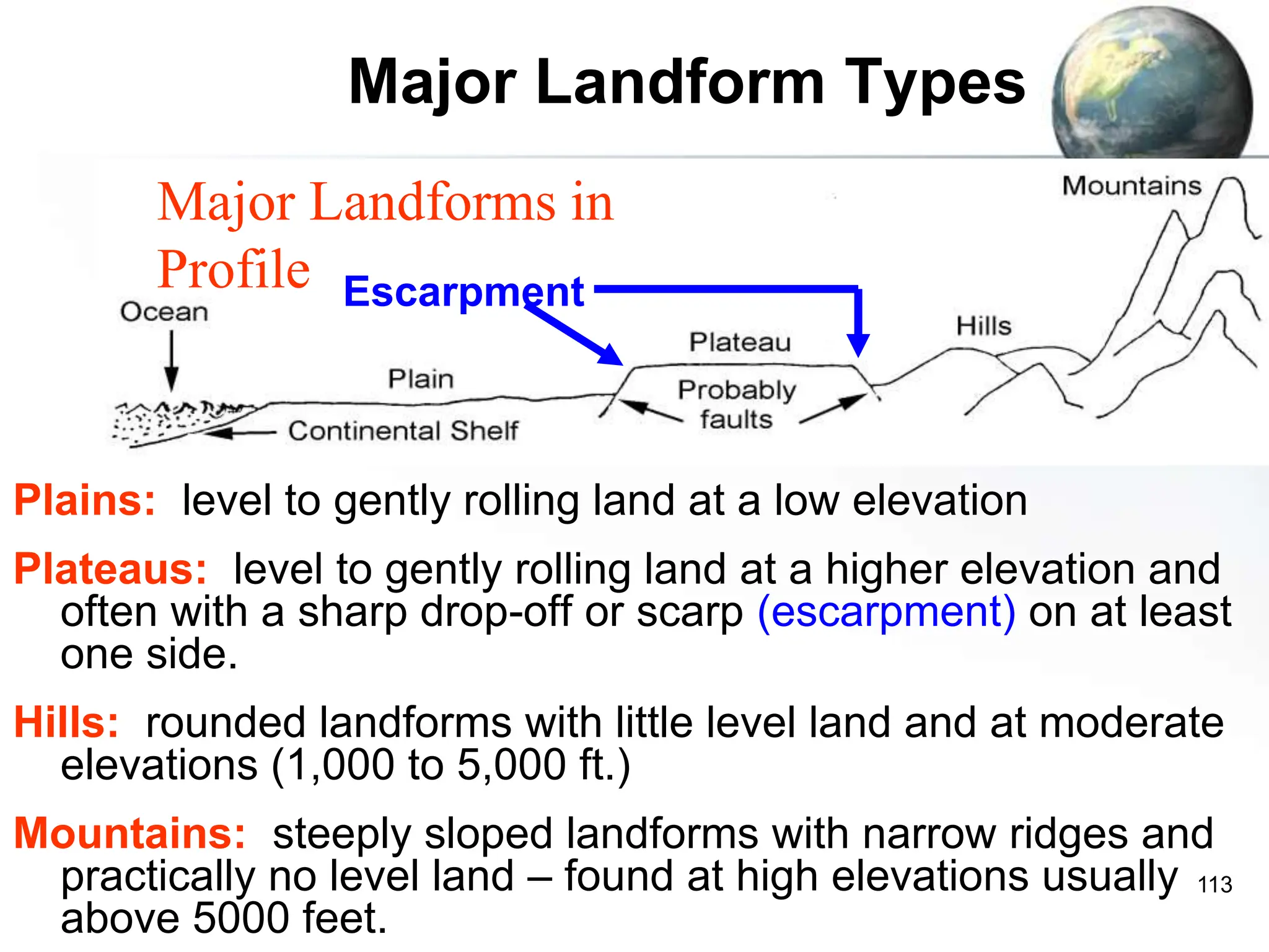
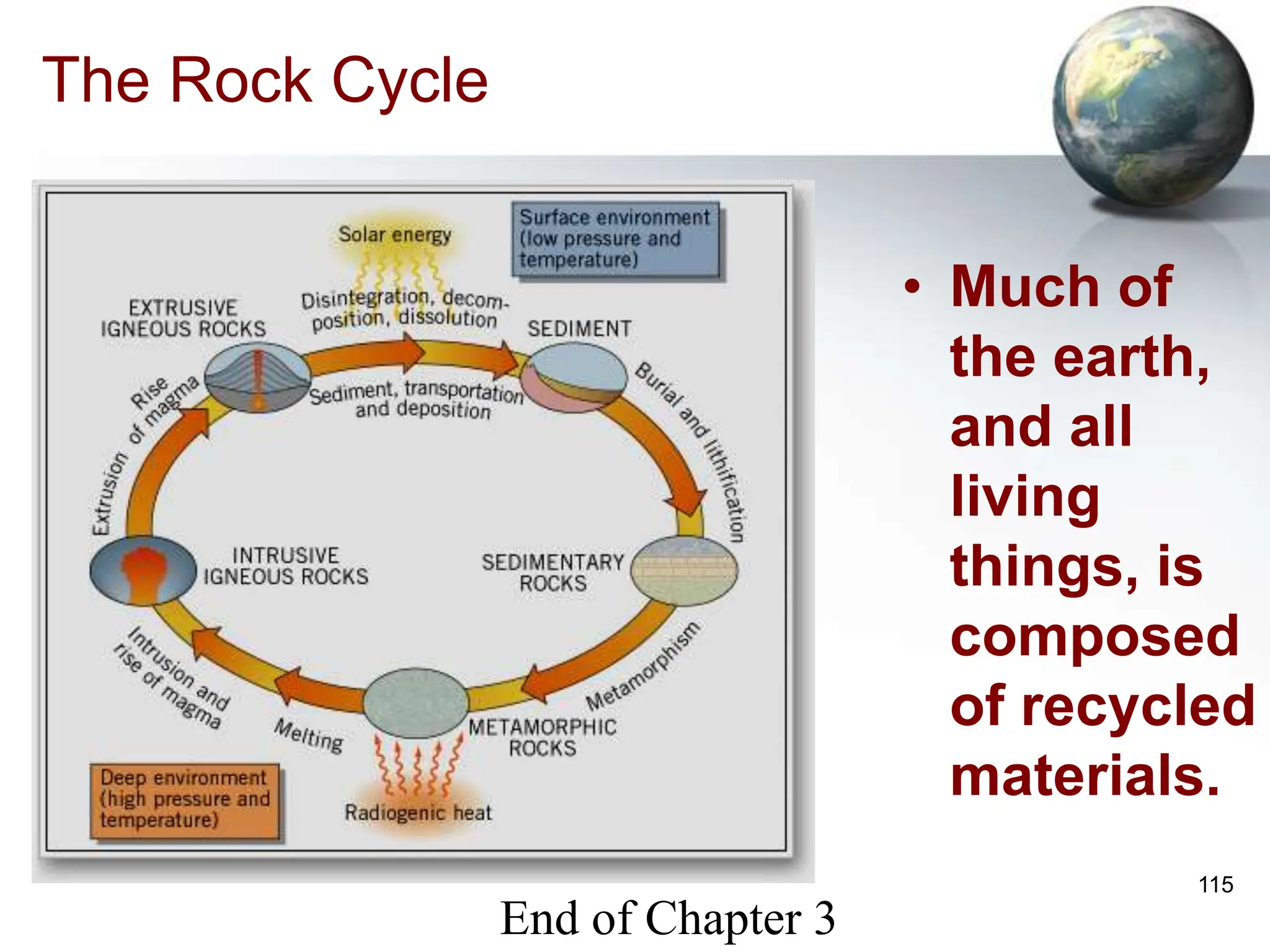
SlideShare a Scribd company logo
1 of 115
Introduction to Geography
People, Places, and Environment, 6e
Carl Dahlman
William H. Renwick
Chapter 3: Landforms: The
Dynamic Earth
Holly Barcus
Morehead State University
And Joe Naumann
UMSL
2
Geologic Time – in 24 hours
• Humans
have
been
around
for ½ of
one
minute
on this
scale.
3
Geomorphology
• Study of landforms and processes that
create them
• Lithosphere
–Rocks and soil
–Surface landforms
• Plains, hills, plateaus, & mountains
• valleys, depressions
4
Landform Processes
• Endogenic (endogenous)
– Internal forces beneath or at Earth’s surface
• Mountain building (diastrophism)
• Earthquakes
• Volcanism
• Exogenic (exogenous)
– External forces
• Weathering – physical (mechanical) & chemical
• Erosion by moving water, air, or ice
5
Endogenous (endogenic) –
Exogenous (exogenic)
• Forces
from Inside
the earth
• Forces
from
outside the
earth
6
Endogenic Forces
• Plate Tectonics
• Volcanism
• Seismic action
7
Plate Tectonics
• Fixed Earth Theory
– Continents and oceans fixed in place
• Pangaea Hypothesis
– Supercontinent
– Alfred Wegener, 1900s
• 1960s = Plate Tectonics Theory
8
Understanding Geological Activity
Spanning Geologic Time
• Continental Drift
– Alfred Wegener, etc.
– International Geophysical Year research
9
Process of Continental Drift
• Appears to be generated by heat-sustained
convection cells in the interior (particularly the
asthenosphere which is not solid)
• Movement occurs where plate boundaries abut
– Divergence – spreading along mid-ocean ridges which lie above
and upwelling in the cell
– Convergence (subduction) – colliding plates over the downward
portion of a convection cell
– Ring of Fire – largely an area of subduction
10
Earth’s Crust & Layers
• Mantle
– Rock beneath
crust
• Tectonic plates
– Earth’s rigid
crust
• Plate movement
– Earthquakes
– Volcanoes
– Mountain
building
11
Convectional Cell Movement
12
Types of Crustal Forces
• Tensional
– dragging
action
• Compres-
sional –
pulling
action
• Sheer –
oblique
action
13
Plate Boundaries: click pictures
• Divergent
– Plates spreading apart
• Seafloor spreading
• Rift Valleys in Africa
• Convergent
– Plates push together
• Dense plates dive below
• Volcanic eruptions
• Transform
– Grinding of plates past each
other
• San Andreas Fault, CA
14
15
Convergent Boundary: click the
diagram below to see the video
• Oceanic plate meets oceanic plate, and
an island arc develops.
16
Convergent Boundary
• Oceanic plate
meets
continental
plate and a
volcanic
mountain chain
forms on the
continental plate
17
Convergent Boundary
• Continental plate meets continental plate and
massive uplift occurs – click picture to see a
video that reviews this type of plate boundary
as well as the others.
18
Earthquakes
• Focus
– Place of actual
movement
• Epicenter
– Surface directly
above focus
• Seismograph
– Recording device for
seismic waves
– Richter Scale, 1935
• Seismic waves
– Recordable vibrations
• Click on the diagram
above to see the video
19
Extent of Seismic Wave Transmission
• Due to
differences in
the nature of
the bedrock in
those areas
• New Madrid
amplifies
more than
San Andreas
20
Richter Scale
• An increase in one whole number signifies an
earthquake 10 times greater power and a
decrease in one number signifies an earthquake
of 1/10th the power
• An increase in two whole numbers signifies an
earthquake of 100 times greater power, etc.
• Compared to a 5.6 quake, one of 6.6 is 10
times more powerful and one of 7.6 is 100 times
more powerful and one of 8.6 is 1000 times
more powerful.
21
Earthquakes
When Where RS Casualties
2/29/1960 Morocco 8.8 12,000
5/21/1960 Southern Chile 9.5 5,700
6/28/1976 Tangshan, China 8.0 750,000
3/31/1983 Papayah, Colombia 5.7 200,000
5/31/1970 Peru 7.7 66,794
6/20/1990 Caspian Sea (Iran) 7.6 50,000
12/7/1988 Armenia 6.9 28,854
22
Earthquake Damage
• Rebound theory -- left
• Alaska ’64 - above
• Some soils may liquefy
Earthquake zones
24
Volcanoes: Most frequent along
subduction zones.
• Magma
– Molten rock below the Earth’s surface
• Lava
– Molten rock reaching Earth’s surface
• Volcano
– Surface vent for lava
25
Volcanoes
• Click on the volcano to see a video
26
Volcano Type: Shield Volcano
• Runny lava – low
relief
• Basalt rock
• Mauna Loa,
Hawaii
• Sedate
Volcano Type: Strato-volcano
• Composite cone volcanoes (strato-volcanoes)
– Krakatau in Indonesia, largest
– Ash, pyroclasts, sulfurous gas
– Explosive
– High relief
29
Life Cycle of a Hot Spot Island
Stages of development: (1) formation over hot spot (2)
moved past the hotspot & inactive (3) being eroded by
the action of the sea.
30
Volcanoes & casualties
When Where Casualties
3/5/1815 Mt. Tambora, E. Indies 162,000
1/11/1683 Mt. Etna, Sicily 60,000
8/26/1883 Krakatau 37,000
5/8/1902
8/30/1902
Mt. Pele, Martinique 29,000
2,000
11/13/1985 Northern Columbia 25,000
3/25/1669 Mt. Etna, Sicily 20,000
1792 Mt. Unzen, Japan 15,000
31
Rock Formation
• Igneous
– Cooled molten crustal material
– Basalt, granite
• Sedimentary
– High pressure
– Sandstone, shale, limestone
• Metamorphic
– Compacted by heat, pressure
– Marble from limestone
– Slate from shale
32
Igneous
Rock
Formation
• Igneous rock is
cooled, hardened
magma or lava
33
Formation of Sedimentary Rock
• Click on the picture to see the video
34
Metamorphic Rock Formation
• Metamorphic
rock has been
structurally
changed – both
igneous and
sedimentary
rock may
become
metamorphic
rock.
35
Minerals - Ores
• Natural substances that comprise rocks
• Types
– Sima
• Denser rocks = silicon, magnesium, iron minerals
– Sial
• Less dense
• Silicon and aluminum
• Distribution
– Crustal movement
– Continental shields
• Mining districts – where concentrations in ore are above
average.
Shields are the anchors of continents, being
composed of the oldest rock formations.
These often contain good mineral deposits.
37
Faults
• Fractures in Earth’s crust from stress
• Types
– Normal
• Divergent plate boundary
• Stretching
– Reverse
• Convergent plate boundary
• Compressed rock
• Appalachian Mountains, Wasatch Range, Himalayas
– Thrust
• Horizontal movement
Normal Fault Reverse Fault
Normal & Reverse Faults
39
Types of Faults – seismic activity
• Normal fault
• Reverse fault
• Left slip fault
• Right slip fault
40
Earthquakes and Volcanoes can
Trigger Tsunamis
• Click on the picture on
the left to see the video
on tsunamis,
particularly December
26, 2004.
41
Rocks & Landforms
• 3 influences
– Crust movement = Landform creation
(endogenic)
– Rock movement
• Reactions to crustal stresses
• Weak (greatly affected by weathering & erosion)
• Strong (less affected by weathering & erosion)
– Mineral composition of rocks affects soils
• Also affects the degree to which it can be
weathered and the type of weathering to which it is
most susceptible.
42
Exogenic Forces
• Weathering
• Erosion – reaction to the force of gravity
overcoming inertia
– Mass wasting
– Moving water
– Moving air
– Moving ice (glaciers)
• Deposition – the flip side of erosion
43
Weathering
• Process of breaking rock into pieces
• First step in formation of soil
– Chemical weathering,
• Process of breaking down rock by:
– Exposure to air and water
– Acids released by decaying vegetation
– Oxidation
– Leaching
– Decomposition of calcium carbonate
– Mechanical weathering
• Process of rocks breaking down by physical force
44
Weathering and Climate
• The combinations of temperature and
precipitation affect the speed and extent of
weathering.
45
Mechanical Weathering: Ice
• Ice contracts as the temperature drops to a point around
4ºF – below that temperature, it begins to expand
• This is the same process that prepares streets for
potholes in the winter.
46
Freezing & Thawing at Work
• frost shattered granite bedrock in Manitoba, Canada –
similar occurrences in Siberia.
47
Mechanical Weathering: Exfoliation
• Some rock seems to
have layers that peel off,
hence the name
• The surface of the rock
expands and contracts
more readily and to a
greater degree than the
interior. This weakens
bonds and the surface
breaks off.
48
Movement of Weathered Material
• Mass movement (Mass wasting)
– Slow gradual movement occurring near the surface,
soil creep
– Dramatic movements such as rock slides, landslides
and mudflows
• Surface erosion
– Caused mostly by rainfall
– Runoff (overland flow)
49
Agents of Erosion and Deposition
• Running Water
– Stream Landscapes
• in Humid Areas
• in Arid Areas
• Groundwater
• Glaciers
• Waves and Currents
• Wind
• Gravity
We live on a water
world where water is
a very active force
70%
50
Humans Are the #1 Earth Movers
1000
1000
4300
14000
24000
30000
45000
0 10000 20000 30000 40000 50000
Tons of earth moved per year
Winds
Ocean Waves
Glaciers
continental mountain building
rivers
oceanic mountain building
Humans
Process
Who Moved the Earth
Series1 1000 1000 4300 14000 24000 30000 45000
Winds
Ocean
Waves
Glaciers
continental
mountain
rivers
oceanic
mountain
Humans
Source:
Discover
Magazine,
October
2004
Remember the damaged houses in
Black Jack, Missouri in the 1970s?
52
Soil Creep at Missouri Bottoms
53
Stream Drainage
• 2 sources
– Ground water
– Overland flow
• Drainage basin
• Discharge
– Volume of water
carried per unit time
• Sediment transport
– Movement of material
– l Deposition
55
Side-cutting by streams
• As the grade
becomes less steep
(as one approaches
the mouth of the
stream), side-cutting
action becomes
more active than
down-cutting and the
valley widens and
the stream
meanders.
56
Running Water: Erosion and
Deposition
• Weathering
breaks rock down
into smaller
pieces which can
then be carried
away by moving
water with
sufficient speed
and volume.
57
Erosion and stream (valley) formation
• Where the slope is steep, the down-cutting action is greatest
• Where the slope is slight, the side-cutting action is greatest.
58
Stages of Stream Development
• Youthful – V-shaped – relatively straight course
• Mature – U-shaped – moderate meandering & possible
braiding
• Old Age – wide floodplain – meandering stream and ox-bow
lakes
59
Stream Action in Humid Areas
Cycle of Landmass
Denudation
60
Stream Action in Arid Areas – less
rounded and more angular landforms
Moving water is the
major erosional and
depositional force
even in desert areas!
61
Stream Gradation
• Exogenic forces operate to reduce all earth land
features to sea level. Click the picture below to see the
video
63
Waterfalls
• Click on the picture below to see the video
64
KARST TOPOGRAPHY
This involves the combination of
chemical weathering and moving
water to create a very unique kind
of topography found where there
are deep layers of limestone.
65
Karst Topography Development
• St. Louis, MO, is located in a karst area.
66
Diagram of Karst Features
• When large caverns collapse, large depressions are
formed
67
Karst Features
UK
Vietnam
Illinois
Sinkhole
Springs
68
Karst Regions
69
Erosion from Human Activity
• Faster than that which occurs geologically
– Accelerates natural processes
• Sharply increase amount of sediment in streams
– Increasing the possibility of and extent of flooding.
• Major contributors include:
– Deforestation – clear-cutting in particular
– Agricultural development
– Urban development – particularly choosing land not well
suited for development, i.e., floodplains
70
Human-enhanced erosion by water
Homes in danger
Sea surges undercut hotel
71
Movement of Water in Soil
• This is a major part of the hydrologic cycle.
72
Using Water Table Water
• The Water table reflects the surface somewhat
• Water drawn from the water table is the major
source for life in some areas.
73
Soil and ground water
• More porous soil (right) allows more water to percolate down into
the soil & move slowly move toward streams, raising them
gradually
• Less porous soil (left) allows more water to run off and raise
stream levels more quickly
74
Vegetative cover encourages water
absorption by soil
• Vegetation temporarily
holds & water releases
it slowly so it can be
more easily absorbed
by the soil.
• Where vegetation is
absent, water may fall
faster then bare earth
can absorb it and run
downhill to streams
causing floods
75
Groundwater Use
• When the rate of withdrawing groundwater exceeds
the rate of recharging, the water table drops. Wet
years with flooding = high water table & drought
years – low water table
Recharging
Withdrawing
76
Artesian systems
• Aquiclude (impermeable rock layer) above and beneath the
aquifer holds or “traps” the water under pressure.
• Often used to irrigate crops in arid areas.
When water is
withdrawn at a rate
greater than the
recharge rate, the
aquifer is gradually
emptied – it will take
nature much longer
to recharge it than
humans to drain it.
77
Flooding can cause big changes
• THEY CALL IT A FLOOPLAIN BECAUSE FLOODING IS A
NATURAL OCCURANCE – IT IS THE “RELEASE VALVE” OF
THE DRAINAGE BASIN
1993 N. Mississippi Basin Flashflood in northern Arizona
78
FLOODPLAINS
• Floodplains are
not appropriate
places for
intensive,
expensive
developments.
Appropriate uses of
floodplains include
farming, wildlife
preserves, parks,
recreation areas for
camping boating, etc.
79
Ice, Wind & Waves
• Glaciers – currently not very active
• Wind causes erosion wherever soil is
bare
– Deserts
– Farmlands
– Coastal areas
• Coastal areas
– Active areas of erosion
– Pounding waves and surf
– Land lost or gained
80
MOVING ICE: GLACIAL
ACTION
Glaciers are melting back more than they are
advancing today. When glaciers advance, erosion is
the major action; however, when they melt back,
deposition is the major action.
81
Alpine Glaciers
• Rivers of ice flowing from colder to warmer
regions
• Act like conveyor belts picking up sediment
and dropping it in depositional areas
– Moraines
• Terminal moraines
• Lateral moraines
• Medial moraines
82
Two Primary Categories
• Alpine or valley glaciers – in the last 100 years,
these have been greatly reduced in number and
size due to melting back.
• Continental glaciers – those that cover large
expanses of land – Antarctica and Greenland are
the last two remaining areas of this type. There is
evidence that both are thinning and shrinking.
83
Glacier Terms:
• Fjord (fiord): As tidewater glaciers retreat, the steep-sided
valleys fill in with sea water.
• Calving: Tidewater glacier sheds icebergs off its face into
the sea -- sections as large as huge buildings.
• Moraines:The accumulation of eroded rock that a glacier
picks up and drops as it recedes. This can be seen at the
face of a glacier (end moraine), the side of a glacier (lateral
moraine) or at the glacier's farthest point of advance
(terminal moraine). Underwater moraine shoals can
decrease the depth of a fjord from hundreds of feet to less
than ten feet over very little distance.
• Terminus:The front or termination of a glacier. The
beginning of a glacier is called its head.
84
Glaciers
• Click on the picture to see the video
85
Valley Glaciers (Alpine) Merging
86
Mountains before glaciation
Before
87
Mountains after glaciation
After
Horn
Bridal veil fall
Pater noster lakes
88
Glacial Valleys & Fjords
• Fiords form when rising sea levels fill the bottom of
coastal glacial valleys after melt back occurs.
89
Coastal Glaciers
• Icebergs
present
a hazard
to
shipping
lanes
Calving
Small fiord
Icebergs
90
Some Glacial Landforms
91
Drumlins & Kames
92
Continental Glaciation
93
4 Advances in North America
94
Glacier Facts #1
• Presently, 10% of land area is covered with glaciers.
• Glaciers store about 75% of the world's freshwater.
• Glacierized areas cover over 15,000,000 square
kilometers.
• Antarctic ice is over 4,200 meters thick in some areas.
• In the United States, glaciers cover over 75,000 square
kilometers, with most of the glaciers located in Alaska.
• During the last Ice Age, glaciers covered 32% of the total
land area.
• If all land ice melted, sea level would rise approximately 70
meters worldwide.
• Glacier ice crystals can grow to be as large as baseballs.
95
Glacier Facts #2
• The land underneath parts of the West Antarctic Ice Sheet
may be up to 2.5 kilometers below sea level, due to the
weight of the ice.
• North America's longest glacier is the Bering Glacier in
Alaska, measuring 204 kilometers long.
• The Malaspina Glacier in Alaska is the world's largest
piedmont glacier, covering over 8,000 square kilometers
and measuring over 193 kilometers across at its widest
point.
• Glacial ice often appears blue because ice absorbs all
other colors and reflects blue.
• Kutiah Glacier in Pakistan holds the record for the fastest
glacial surge. In 1953, it raced more than 12 km in three
months, averaging 112 meters per day
96
Glacier Facts #3
• In Washington state alone, glaciers provide 470
billion gallons of water each summer.
• Antarctic ice shelves may calve icebergs that are
over 80 kilometers long.
• Almost 90% of an iceberg is below water--only
about 10% shows above water.
• The Antarctic ice sheet has been in existence for at
least 40 million years.
• From the 17th century to the late 19th century, the
world experienced a "Little Ice Age," when
temperatures were consistently cool enough for
significant glacier advances.
98
Impact of Past Glaciations
• Soils
– Advance and retreat of glaciers leave behind
highly fertile soil
• Water supply
– Retreating glaciers left sand and gravel
deposits yielding large supplies of ground water
• Transportation routes
– Water transport is heavily influenced by glacial
melt water channels left behind by receding
glaciers
• Check Ohio & Missouri River courses!
99
WIND ACTION
Wind is most active in arid
regions, but never as
important as water in
altering the earth surface
and creating landforms
100
Effects of Wind on Landforms
• Significant shaper of landforms in dry
regions and regions not well covered by
vegetation
• Carries great quantity of fine grained
sediment such as sand and loess
101
Wind Speed
• As the wind speed
increases, larger particles
can be carried by the
wind (erosion)
• As the wind speed
decreases, larger
particles begin to settle to
the surface first
(deposition)
102
Arid Landscapes
• Erosion and
deposition by wind
helped create this
landscape, BUT
moving water was
the more active
shaping force here.
103
Land shaping water in the desert
• Water
carved
this
canyon
and wind
and mass
wasting
assisted.
104
Coastal Erosion
• Waves
– Form of energy traveling horizontally along the
boundary between water and air
• Longshore currents
– Currents traveling parallel to the shore, caused by
repeated breaking of waves. Capable of carrying
enormous amounts of sediment
• Sea-level change
– Continuing to rise as seawater volume increases from
glacial melting
– Causes increased erosion as waves break closer to
shore
105
Oceans, Waves, & Gradation
• Wave
action
erodes and
builds the
coastal
margins of
islands and
continents
109
Dynamic Waves and Currents
• The shoreline is constantly changing – click on the
picture below to see the video
110
Rates of Landform Change
• Horizontal movement
• Vertical movement
• Human activity
112
Landform Regions
• Plains
• Hills and Low
Tablelands
• High
Tablelands
• Mountains
• Widely Spaced
Mountains
• Basins or
Depressions
113
Major Landform Types
Plains: level to gently rolling land at a low elevation
Plateaus: level to gently rolling land at a higher elevation and
often with a sharp drop-off or scarp (escarpment) on at least
one side.
Hills: rounded landforms with little level land and at moderate
elevations (1,000 to 5,000 ft.)
Mountains: steeply sloped landforms with narrow ridges and
practically no level land – found at high elevations usually
above 5000 feet.
Major Landforms in
Profile Escarpment
114
Environmental Hazards
• Environmental processes
–Natural
– Tornadoes, landslides, earthquakes
–Human vulnerability
– Rebuilding after natural disaster
– Seawalls
– Levees
115
The Rock Cycle
• Much of
the earth,
and all
living
things, is
composed
of recycled
materials.
End of Chapter 3

More Related Content

Similar to Chapter03 for CD.ppt

Earthquake-Volcanoes-and-Mountains.ppt
Earthquake-Volcanoes-and-Mountains.pptEarthquake-Volcanoes-and-Mountains.ppt
Earthquake-Volcanoes-and-Mountains.pptMandapAneczar
 
mountainsearthquakesandvolcanoes-120925073803-phpapp01.pdf
mountainsearthquakesandvolcanoes-120925073803-phpapp01.pdfmountainsearthquakesandvolcanoes-120925073803-phpapp01.pdf
mountainsearthquakesandvolcanoes-120925073803-phpapp01.pdfFloraMaeMasangcayDai
 
Lithosphere 2: Tectonics
Lithosphere 2: TectonicsLithosphere 2: Tectonics
Lithosphere 2: TectonicsRobin Seamon
 
A presentation on earthquake
A presentation on earthquakeA presentation on earthquake
A presentation on earthquakeEijajul Islam
 
Importance of forest
Importance of forestImportance of forest
Importance of forestKuberMaihar
 
structuraleq.ppt
structuraleq.pptstructuraleq.ppt
structuraleq.pptAkamGardy
 
Unit 2 - Earthquakes and Volcanoes (2017/2018)
Unit 2 - Earthquakes and Volcanoes (2017/2018)Unit 2 - Earthquakes and Volcanoes (2017/2018)
Unit 2 - Earthquakes and Volcanoes (2017/2018)Josh Macha
 
Chs 6 & 7 - Earthquakes & Volcanoes
Chs 6 & 7 - Earthquakes & Volcanoes Chs 6 & 7 - Earthquakes & Volcanoes
Chs 6 & 7 - Earthquakes & Volcanoes nilsona
 
Design Steps for Earthquake Resistant Structures
Design Steps for Earthquake Resistant StructuresDesign Steps for Earthquake Resistant Structures
Design Steps for Earthquake Resistant StructuresIshan Garg
 
Mountains, earthquakes, and volcanoes
Mountains, earthquakes, and volcanoesMountains, earthquakes, and volcanoes
Mountains, earthquakes, and volcanoesharvey09
 
Lecture 2-The Dynamic Earth.pdf
Lecture 2-The Dynamic Earth.pdfLecture 2-The Dynamic Earth.pdf
Lecture 2-The Dynamic Earth.pdfMichael706438
 
GEOG 100--Lecture 12--Plate Tectonics
GEOG 100--Lecture 12--Plate TectonicsGEOG 100--Lecture 12--Plate Tectonics
GEOG 100--Lecture 12--Plate Tectonicsangelaorr
 
Earthquake
EarthquakeEarthquake
EarthquakeKp Ahm
 
U11. the dynamics of the earth
U11. the dynamics of the earthU11. the dynamics of the earth
U11. the dynamics of the earthanaruperez
 
Folding_Faulting_Volcanism.pptx
Folding_Faulting_Volcanism.pptxFolding_Faulting_Volcanism.pptx
Folding_Faulting_Volcanism.pptxFrancis de Castro
 

Similar to Chapter03 for CD.ppt (20)

Earthquake-Volcanoes-and-Mountains.ppt
Earthquake-Volcanoes-and-Mountains.pptEarthquake-Volcanoes-and-Mountains.ppt
Earthquake-Volcanoes-and-Mountains.ppt
 
Chapter 2.in geomorphology
Chapter 2.in geomorphologyChapter 2.in geomorphology
Chapter 2.in geomorphology
 
mountainsearthquakesandvolcanoes-120925073803-phpapp01.pdf
mountainsearthquakesandvolcanoes-120925073803-phpapp01.pdfmountainsearthquakesandvolcanoes-120925073803-phpapp01.pdf
mountainsearthquakesandvolcanoes-120925073803-phpapp01.pdf
 
Lithosphere 2: Tectonics
Lithosphere 2: TectonicsLithosphere 2: Tectonics
Lithosphere 2: Tectonics
 
A presentation on earthquake
A presentation on earthquakeA presentation on earthquake
A presentation on earthquake
 
The Earth
The EarthThe Earth
The Earth
 
Importance of forest
Importance of forestImportance of forest
Importance of forest
 
structuraleq.ppt
structuraleq.pptstructuraleq.ppt
structuraleq.ppt
 
Unit 2 - Earthquakes and Volcanoes (2017/2018)
Unit 2 - Earthquakes and Volcanoes (2017/2018)Unit 2 - Earthquakes and Volcanoes (2017/2018)
Unit 2 - Earthquakes and Volcanoes (2017/2018)
 
Chs 6 & 7 - Earthquakes & Volcanoes
Chs 6 & 7 - Earthquakes & Volcanoes Chs 6 & 7 - Earthquakes & Volcanoes
Chs 6 & 7 - Earthquakes & Volcanoes
 
Design Steps for Earthquake Resistant Structures
Design Steps for Earthquake Resistant StructuresDesign Steps for Earthquake Resistant Structures
Design Steps for Earthquake Resistant Structures
 
Mountains, earthquakes, and volcanoes
Mountains, earthquakes, and volcanoesMountains, earthquakes, and volcanoes
Mountains, earthquakes, and volcanoes
 
Lecture 2-The Dynamic Earth.pdf
Lecture 2-The Dynamic Earth.pdfLecture 2-The Dynamic Earth.pdf
Lecture 2-The Dynamic Earth.pdf
 
unit iii ppt.pptx
unit iii ppt.pptxunit iii ppt.pptx
unit iii ppt.pptx
 
Plates
PlatesPlates
Plates
 
GEOG 100--Lecture 12--Plate Tectonics
GEOG 100--Lecture 12--Plate TectonicsGEOG 100--Lecture 12--Plate Tectonics
GEOG 100--Lecture 12--Plate Tectonics
 
EARTHQUAKE (25 to 30).pdf
EARTHQUAKE (25 to 30).pdfEARTHQUAKE (25 to 30).pdf
EARTHQUAKE (25 to 30).pdf
 
Earthquake
EarthquakeEarthquake
Earthquake
 
U11. the dynamics of the earth
U11. the dynamics of the earthU11. the dynamics of the earth
U11. the dynamics of the earth
 
Folding_Faulting_Volcanism.pptx
Folding_Faulting_Volcanism.pptxFolding_Faulting_Volcanism.pptx
Folding_Faulting_Volcanism.pptx
 

Recently uploaded

KSHARA STURA .pptx---KSHARA KARMA THERAPY (CAUSTIC THERAPY)————IMP.OF KSHARA ...
KSHARA STURA .pptx---KSHARA KARMA THERAPY (CAUSTIC THERAPY)————IMP.OF KSHARA ...KSHARA STURA .pptx---KSHARA KARMA THERAPY (CAUSTIC THERAPY)————IMP.OF KSHARA ...
KSHARA STURA .pptx---KSHARA KARMA THERAPY (CAUSTIC THERAPY)————IMP.OF KSHARA ...M56BOOKSTORE PRODUCT/SERVICE
 
CELL CYCLE Division Science 8 quarter IV.pptx
CELL CYCLE Division Science 8 quarter IV.pptxCELL CYCLE Division Science 8 quarter IV.pptx
CELL CYCLE Division Science 8 quarter IV.pptxJiesonDelaCerna
 
Final demo Grade 9 for demo Plan dessert.pptx
Final demo Grade 9 for demo Plan dessert.pptxFinal demo Grade 9 for demo Plan dessert.pptx
Final demo Grade 9 for demo Plan dessert.pptxAvyJaneVismanos
 
Historical philosophical, theoretical, and legal foundations of special and i...
Historical philosophical, theoretical, and legal foundations of special and i...Historical philosophical, theoretical, and legal foundations of special and i...
Historical philosophical, theoretical, and legal foundations of special and i...jaredbarbolino94
 
MARGINALIZATION (Different learners in Marginalized Group
MARGINALIZATION (Different learners in Marginalized GroupMARGINALIZATION (Different learners in Marginalized Group
MARGINALIZATION (Different learners in Marginalized GroupJonathanParaisoCruz
 
Organic Name Reactions for the students and aspirants of Chemistry12th.pptx
Organic Name Reactions  for the students and aspirants of Chemistry12th.pptxOrganic Name Reactions  for the students and aspirants of Chemistry12th.pptx
Organic Name Reactions for the students and aspirants of Chemistry12th.pptxVS Mahajan Coaching Centre
 
Painted Grey Ware.pptx, PGW Culture of India
Painted Grey Ware.pptx, PGW Culture of IndiaPainted Grey Ware.pptx, PGW Culture of India
Painted Grey Ware.pptx, PGW Culture of IndiaVirag Sontakke
 
ECONOMIC CONTEXT - PAPER 1 Q3: NEWSPAPERS.pptx
ECONOMIC CONTEXT - PAPER 1 Q3: NEWSPAPERS.pptxECONOMIC CONTEXT - PAPER 1 Q3: NEWSPAPERS.pptx
ECONOMIC CONTEXT - PAPER 1 Q3: NEWSPAPERS.pptxiammrhaywood
 
Employee wellbeing at the workplace.pptx
Employee wellbeing at the workplace.pptxEmployee wellbeing at the workplace.pptx
Employee wellbeing at the workplace.pptxNirmalaLoungPoorunde1
 
CARE OF CHILD IN INCUBATOR..........pptx
CARE OF CHILD IN INCUBATOR..........pptxCARE OF CHILD IN INCUBATOR..........pptx
CARE OF CHILD IN INCUBATOR..........pptxGaneshChakor2
 
Meghan Sutherland In Media Res Media Component
Meghan Sutherland In Media Res Media ComponentMeghan Sutherland In Media Res Media Component
Meghan Sutherland In Media Res Media ComponentInMediaRes1
 
DATA STRUCTURE AND ALGORITHM for beginners
DATA STRUCTURE AND ALGORITHM for beginnersDATA STRUCTURE AND ALGORITHM for beginners
DATA STRUCTURE AND ALGORITHM for beginnersSabitha Banu
 
call girls in Kamla Market (DELHI) 🔝 >༒9953330565🔝 genuine Escort Service 🔝✔️✔️
call girls in Kamla Market (DELHI) 🔝 >༒9953330565🔝 genuine Escort Service 🔝✔️✔️call girls in Kamla Market (DELHI) 🔝 >༒9953330565🔝 genuine Escort Service 🔝✔️✔️
call girls in Kamla Market (DELHI) 🔝 >༒9953330565🔝 genuine Escort Service 🔝✔️✔️9953056974 Low Rate Call Girls In Saket, Delhi NCR
 
Computed Fields and api Depends in the Odoo 17
Computed Fields and api Depends in the Odoo 17Computed Fields and api Depends in the Odoo 17
Computed Fields and api Depends in the Odoo 17Celine George
 
How to Configure Email Server in Odoo 17
How to Configure Email Server in Odoo 17How to Configure Email Server in Odoo 17
How to Configure Email Server in Odoo 17Celine George
 
Earth Day Presentation wow hello nice great
Earth Day Presentation wow hello nice greatEarth Day Presentation wow hello nice great
Earth Day Presentation wow hello nice greatYousafMalik24
 
Types of Journalistic Writing Grade 8.pptx
Types of Journalistic Writing Grade 8.pptxTypes of Journalistic Writing Grade 8.pptx
Types of Journalistic Writing Grade 8.pptxEyham Joco
 
Framing an Appropriate Research Question 6b9b26d93da94caf993c038d9efcdedb.pdf
Framing an Appropriate Research Question 6b9b26d93da94caf993c038d9efcdedb.pdfFraming an Appropriate Research Question 6b9b26d93da94caf993c038d9efcdedb.pdf
Framing an Appropriate Research Question 6b9b26d93da94caf993c038d9efcdedb.pdfUjwalaBharambe
 

Recently uploaded (20)

KSHARA STURA .pptx---KSHARA KARMA THERAPY (CAUSTIC THERAPY)————IMP.OF KSHARA ...
KSHARA STURA .pptx---KSHARA KARMA THERAPY (CAUSTIC THERAPY)————IMP.OF KSHARA ...KSHARA STURA .pptx---KSHARA KARMA THERAPY (CAUSTIC THERAPY)————IMP.OF KSHARA ...
KSHARA STURA .pptx---KSHARA KARMA THERAPY (CAUSTIC THERAPY)————IMP.OF KSHARA ...
 
CELL CYCLE Division Science 8 quarter IV.pptx
CELL CYCLE Division Science 8 quarter IV.pptxCELL CYCLE Division Science 8 quarter IV.pptx
CELL CYCLE Division Science 8 quarter IV.pptx
 
Final demo Grade 9 for demo Plan dessert.pptx
Final demo Grade 9 for demo Plan dessert.pptxFinal demo Grade 9 for demo Plan dessert.pptx
Final demo Grade 9 for demo Plan dessert.pptx
 
Historical philosophical, theoretical, and legal foundations of special and i...
Historical philosophical, theoretical, and legal foundations of special and i...Historical philosophical, theoretical, and legal foundations of special and i...
Historical philosophical, theoretical, and legal foundations of special and i...
 
MARGINALIZATION (Different learners in Marginalized Group
MARGINALIZATION (Different learners in Marginalized GroupMARGINALIZATION (Different learners in Marginalized Group
MARGINALIZATION (Different learners in Marginalized Group
 
Model Call Girl in Tilak Nagar Delhi reach out to us at 🔝9953056974🔝
Model Call Girl in Tilak Nagar Delhi reach out to us at 🔝9953056974🔝Model Call Girl in Tilak Nagar Delhi reach out to us at 🔝9953056974🔝
Model Call Girl in Tilak Nagar Delhi reach out to us at 🔝9953056974🔝
 
Organic Name Reactions for the students and aspirants of Chemistry12th.pptx
Organic Name Reactions  for the students and aspirants of Chemistry12th.pptxOrganic Name Reactions  for the students and aspirants of Chemistry12th.pptx
Organic Name Reactions for the students and aspirants of Chemistry12th.pptx
 
Painted Grey Ware.pptx, PGW Culture of India
Painted Grey Ware.pptx, PGW Culture of IndiaPainted Grey Ware.pptx, PGW Culture of India
Painted Grey Ware.pptx, PGW Culture of India
 
ECONOMIC CONTEXT - PAPER 1 Q3: NEWSPAPERS.pptx
ECONOMIC CONTEXT - PAPER 1 Q3: NEWSPAPERS.pptxECONOMIC CONTEXT - PAPER 1 Q3: NEWSPAPERS.pptx
ECONOMIC CONTEXT - PAPER 1 Q3: NEWSPAPERS.pptx
 
Employee wellbeing at the workplace.pptx
Employee wellbeing at the workplace.pptxEmployee wellbeing at the workplace.pptx
Employee wellbeing at the workplace.pptx
 
CARE OF CHILD IN INCUBATOR..........pptx
CARE OF CHILD IN INCUBATOR..........pptxCARE OF CHILD IN INCUBATOR..........pptx
CARE OF CHILD IN INCUBATOR..........pptx
 
Meghan Sutherland In Media Res Media Component
Meghan Sutherland In Media Res Media ComponentMeghan Sutherland In Media Res Media Component
Meghan Sutherland In Media Res Media Component
 
9953330565 Low Rate Call Girls In Rohini Delhi NCR
9953330565 Low Rate Call Girls In Rohini  Delhi NCR9953330565 Low Rate Call Girls In Rohini  Delhi NCR
9953330565 Low Rate Call Girls In Rohini Delhi NCR
 
DATA STRUCTURE AND ALGORITHM for beginners
DATA STRUCTURE AND ALGORITHM for beginnersDATA STRUCTURE AND ALGORITHM for beginners
DATA STRUCTURE AND ALGORITHM for beginners
 
call girls in Kamla Market (DELHI) 🔝 >༒9953330565🔝 genuine Escort Service 🔝✔️✔️
call girls in Kamla Market (DELHI) 🔝 >༒9953330565🔝 genuine Escort Service 🔝✔️✔️call girls in Kamla Market (DELHI) 🔝 >༒9953330565🔝 genuine Escort Service 🔝✔️✔️
call girls in Kamla Market (DELHI) 🔝 >༒9953330565🔝 genuine Escort Service 🔝✔️✔️
 
Computed Fields and api Depends in the Odoo 17
Computed Fields and api Depends in the Odoo 17Computed Fields and api Depends in the Odoo 17
Computed Fields and api Depends in the Odoo 17
 
How to Configure Email Server in Odoo 17
How to Configure Email Server in Odoo 17How to Configure Email Server in Odoo 17
How to Configure Email Server in Odoo 17
 
Earth Day Presentation wow hello nice great
Earth Day Presentation wow hello nice greatEarth Day Presentation wow hello nice great
Earth Day Presentation wow hello nice great
 
Types of Journalistic Writing Grade 8.pptx
Types of Journalistic Writing Grade 8.pptxTypes of Journalistic Writing Grade 8.pptx
Types of Journalistic Writing Grade 8.pptx
 
Framing an Appropriate Research Question 6b9b26d93da94caf993c038d9efcdedb.pdf
Framing an Appropriate Research Question 6b9b26d93da94caf993c038d9efcdedb.pdfFraming an Appropriate Research Question 6b9b26d93da94caf993c038d9efcdedb.pdf
Framing an Appropriate Research Question 6b9b26d93da94caf993c038d9efcdedb.pdf
 

Chapter03 for CD.ppt

  • 1. Introduction to Geography People, Places, and Environment, 6e Carl Dahlman William H. Renwick Chapter 3: Landforms: The Dynamic Earth Holly Barcus Morehead State University And Joe Naumann UMSL
  • 2. 2 Geologic Time – in 24 hours • Humans have been around for ½ of one minute on this scale.
  • 3. 3 Geomorphology • Study of landforms and processes that create them • Lithosphere –Rocks and soil –Surface landforms • Plains, hills, plateaus, & mountains • valleys, depressions
  • 4. 4 Landform Processes • Endogenic (endogenous) – Internal forces beneath or at Earth’s surface • Mountain building (diastrophism) • Earthquakes • Volcanism • Exogenic (exogenous) – External forces • Weathering – physical (mechanical) & chemical • Erosion by moving water, air, or ice
  • 5. 5 Endogenous (endogenic) – Exogenous (exogenic) • Forces from Inside the earth • Forces from outside the earth
  • 6. 6 Endogenic Forces • Plate Tectonics • Volcanism • Seismic action
  • 7. 7 Plate Tectonics • Fixed Earth Theory – Continents and oceans fixed in place • Pangaea Hypothesis – Supercontinent – Alfred Wegener, 1900s • 1960s = Plate Tectonics Theory
  • 8. 8 Understanding Geological Activity Spanning Geologic Time • Continental Drift – Alfred Wegener, etc. – International Geophysical Year research
  • 9. 9 Process of Continental Drift • Appears to be generated by heat-sustained convection cells in the interior (particularly the asthenosphere which is not solid) • Movement occurs where plate boundaries abut – Divergence – spreading along mid-ocean ridges which lie above and upwelling in the cell – Convergence (subduction) – colliding plates over the downward portion of a convection cell – Ring of Fire – largely an area of subduction
  • 10. 10 Earth’s Crust & Layers • Mantle – Rock beneath crust • Tectonic plates – Earth’s rigid crust • Plate movement – Earthquakes – Volcanoes – Mountain building
  • 12. 12 Types of Crustal Forces • Tensional – dragging action • Compres- sional – pulling action • Sheer – oblique action
  • 13. 13 Plate Boundaries: click pictures • Divergent – Plates spreading apart • Seafloor spreading • Rift Valleys in Africa • Convergent – Plates push together • Dense plates dive below • Volcanic eruptions • Transform – Grinding of plates past each other • San Andreas Fault, CA
  • 14. 14
  • 15. 15 Convergent Boundary: click the diagram below to see the video • Oceanic plate meets oceanic plate, and an island arc develops.
  • 16. 16 Convergent Boundary • Oceanic plate meets continental plate and a volcanic mountain chain forms on the continental plate
  • 17. 17 Convergent Boundary • Continental plate meets continental plate and massive uplift occurs – click picture to see a video that reviews this type of plate boundary as well as the others.
  • 18. 18 Earthquakes • Focus – Place of actual movement • Epicenter – Surface directly above focus • Seismograph – Recording device for seismic waves – Richter Scale, 1935 • Seismic waves – Recordable vibrations • Click on the diagram above to see the video
  • 19. 19 Extent of Seismic Wave Transmission • Due to differences in the nature of the bedrock in those areas • New Madrid amplifies more than San Andreas
  • 20. 20 Richter Scale • An increase in one whole number signifies an earthquake 10 times greater power and a decrease in one number signifies an earthquake of 1/10th the power • An increase in two whole numbers signifies an earthquake of 100 times greater power, etc. • Compared to a 5.6 quake, one of 6.6 is 10 times more powerful and one of 7.6 is 100 times more powerful and one of 8.6 is 1000 times more powerful.
  • 21. 21 Earthquakes When Where RS Casualties 2/29/1960 Morocco 8.8 12,000 5/21/1960 Southern Chile 9.5 5,700 6/28/1976 Tangshan, China 8.0 750,000 3/31/1983 Papayah, Colombia 5.7 200,000 5/31/1970 Peru 7.7 66,794 6/20/1990 Caspian Sea (Iran) 7.6 50,000 12/7/1988 Armenia 6.9 28,854
  • 22. 22 Earthquake Damage • Rebound theory -- left • Alaska ’64 - above • Some soils may liquefy
  • 24. 24 Volcanoes: Most frequent along subduction zones. • Magma – Molten rock below the Earth’s surface • Lava – Molten rock reaching Earth’s surface • Volcano – Surface vent for lava
  • 25. 25 Volcanoes • Click on the volcano to see a video
  • 26. 26 Volcano Type: Shield Volcano • Runny lava – low relief • Basalt rock • Mauna Loa, Hawaii • Sedate
  • 27. Volcano Type: Strato-volcano • Composite cone volcanoes (strato-volcanoes) – Krakatau in Indonesia, largest – Ash, pyroclasts, sulfurous gas – Explosive – High relief
  • 28.
  • 29. 29 Life Cycle of a Hot Spot Island Stages of development: (1) formation over hot spot (2) moved past the hotspot & inactive (3) being eroded by the action of the sea.
  • 30. 30 Volcanoes & casualties When Where Casualties 3/5/1815 Mt. Tambora, E. Indies 162,000 1/11/1683 Mt. Etna, Sicily 60,000 8/26/1883 Krakatau 37,000 5/8/1902 8/30/1902 Mt. Pele, Martinique 29,000 2,000 11/13/1985 Northern Columbia 25,000 3/25/1669 Mt. Etna, Sicily 20,000 1792 Mt. Unzen, Japan 15,000
  • 31. 31 Rock Formation • Igneous – Cooled molten crustal material – Basalt, granite • Sedimentary – High pressure – Sandstone, shale, limestone • Metamorphic – Compacted by heat, pressure – Marble from limestone – Slate from shale
  • 32. 32 Igneous Rock Formation • Igneous rock is cooled, hardened magma or lava
  • 33. 33 Formation of Sedimentary Rock • Click on the picture to see the video
  • 34. 34 Metamorphic Rock Formation • Metamorphic rock has been structurally changed – both igneous and sedimentary rock may become metamorphic rock.
  • 35. 35 Minerals - Ores • Natural substances that comprise rocks • Types – Sima • Denser rocks = silicon, magnesium, iron minerals – Sial • Less dense • Silicon and aluminum • Distribution – Crustal movement – Continental shields • Mining districts – where concentrations in ore are above average.
  • 36. Shields are the anchors of continents, being composed of the oldest rock formations. These often contain good mineral deposits.
  • 37. 37 Faults • Fractures in Earth’s crust from stress • Types – Normal • Divergent plate boundary • Stretching – Reverse • Convergent plate boundary • Compressed rock • Appalachian Mountains, Wasatch Range, Himalayas – Thrust • Horizontal movement
  • 38. Normal Fault Reverse Fault Normal & Reverse Faults
  • 39. 39 Types of Faults – seismic activity • Normal fault • Reverse fault • Left slip fault • Right slip fault
  • 40. 40 Earthquakes and Volcanoes can Trigger Tsunamis • Click on the picture on the left to see the video on tsunamis, particularly December 26, 2004.
  • 41. 41 Rocks & Landforms • 3 influences – Crust movement = Landform creation (endogenic) – Rock movement • Reactions to crustal stresses • Weak (greatly affected by weathering & erosion) • Strong (less affected by weathering & erosion) – Mineral composition of rocks affects soils • Also affects the degree to which it can be weathered and the type of weathering to which it is most susceptible.
  • 42. 42 Exogenic Forces • Weathering • Erosion – reaction to the force of gravity overcoming inertia – Mass wasting – Moving water – Moving air – Moving ice (glaciers) • Deposition – the flip side of erosion
  • 43. 43 Weathering • Process of breaking rock into pieces • First step in formation of soil – Chemical weathering, • Process of breaking down rock by: – Exposure to air and water – Acids released by decaying vegetation – Oxidation – Leaching – Decomposition of calcium carbonate – Mechanical weathering • Process of rocks breaking down by physical force
  • 44. 44 Weathering and Climate • The combinations of temperature and precipitation affect the speed and extent of weathering.
  • 45. 45 Mechanical Weathering: Ice • Ice contracts as the temperature drops to a point around 4ºF – below that temperature, it begins to expand • This is the same process that prepares streets for potholes in the winter.
  • 46. 46 Freezing & Thawing at Work • frost shattered granite bedrock in Manitoba, Canada – similar occurrences in Siberia.
  • 47. 47 Mechanical Weathering: Exfoliation • Some rock seems to have layers that peel off, hence the name • The surface of the rock expands and contracts more readily and to a greater degree than the interior. This weakens bonds and the surface breaks off.
  • 48. 48 Movement of Weathered Material • Mass movement (Mass wasting) – Slow gradual movement occurring near the surface, soil creep – Dramatic movements such as rock slides, landslides and mudflows • Surface erosion – Caused mostly by rainfall – Runoff (overland flow)
  • 49. 49 Agents of Erosion and Deposition • Running Water – Stream Landscapes • in Humid Areas • in Arid Areas • Groundwater • Glaciers • Waves and Currents • Wind • Gravity We live on a water world where water is a very active force 70%
  • 50. 50 Humans Are the #1 Earth Movers 1000 1000 4300 14000 24000 30000 45000 0 10000 20000 30000 40000 50000 Tons of earth moved per year Winds Ocean Waves Glaciers continental mountain building rivers oceanic mountain building Humans Process Who Moved the Earth Series1 1000 1000 4300 14000 24000 30000 45000 Winds Ocean Waves Glaciers continental mountain rivers oceanic mountain Humans Source: Discover Magazine, October 2004
  • 51. Remember the damaged houses in Black Jack, Missouri in the 1970s?
  • 52. 52 Soil Creep at Missouri Bottoms
  • 53. 53 Stream Drainage • 2 sources – Ground water – Overland flow • Drainage basin • Discharge – Volume of water carried per unit time • Sediment transport – Movement of material – l Deposition
  • 54.
  • 55. 55 Side-cutting by streams • As the grade becomes less steep (as one approaches the mouth of the stream), side-cutting action becomes more active than down-cutting and the valley widens and the stream meanders.
  • 56. 56 Running Water: Erosion and Deposition • Weathering breaks rock down into smaller pieces which can then be carried away by moving water with sufficient speed and volume.
  • 57. 57 Erosion and stream (valley) formation • Where the slope is steep, the down-cutting action is greatest • Where the slope is slight, the side-cutting action is greatest.
  • 58. 58 Stages of Stream Development • Youthful – V-shaped – relatively straight course • Mature – U-shaped – moderate meandering & possible braiding • Old Age – wide floodplain – meandering stream and ox-bow lakes
  • 59. 59 Stream Action in Humid Areas Cycle of Landmass Denudation
  • 60. 60 Stream Action in Arid Areas – less rounded and more angular landforms Moving water is the major erosional and depositional force even in desert areas!
  • 61. 61 Stream Gradation • Exogenic forces operate to reduce all earth land features to sea level. Click the picture below to see the video
  • 62.
  • 63. 63 Waterfalls • Click on the picture below to see the video
  • 64. 64 KARST TOPOGRAPHY This involves the combination of chemical weathering and moving water to create a very unique kind of topography found where there are deep layers of limestone.
  • 65. 65 Karst Topography Development • St. Louis, MO, is located in a karst area.
  • 66. 66 Diagram of Karst Features • When large caverns collapse, large depressions are formed
  • 69. 69 Erosion from Human Activity • Faster than that which occurs geologically – Accelerates natural processes • Sharply increase amount of sediment in streams – Increasing the possibility of and extent of flooding. • Major contributors include: – Deforestation – clear-cutting in particular – Agricultural development – Urban development – particularly choosing land not well suited for development, i.e., floodplains
  • 70. 70 Human-enhanced erosion by water Homes in danger Sea surges undercut hotel
  • 71. 71 Movement of Water in Soil • This is a major part of the hydrologic cycle.
  • 72. 72 Using Water Table Water • The Water table reflects the surface somewhat • Water drawn from the water table is the major source for life in some areas.
  • 73. 73 Soil and ground water • More porous soil (right) allows more water to percolate down into the soil & move slowly move toward streams, raising them gradually • Less porous soil (left) allows more water to run off and raise stream levels more quickly
  • 74. 74 Vegetative cover encourages water absorption by soil • Vegetation temporarily holds & water releases it slowly so it can be more easily absorbed by the soil. • Where vegetation is absent, water may fall faster then bare earth can absorb it and run downhill to streams causing floods
  • 75. 75 Groundwater Use • When the rate of withdrawing groundwater exceeds the rate of recharging, the water table drops. Wet years with flooding = high water table & drought years – low water table Recharging Withdrawing
  • 76. 76 Artesian systems • Aquiclude (impermeable rock layer) above and beneath the aquifer holds or “traps” the water under pressure. • Often used to irrigate crops in arid areas. When water is withdrawn at a rate greater than the recharge rate, the aquifer is gradually emptied – it will take nature much longer to recharge it than humans to drain it.
  • 77. 77 Flooding can cause big changes • THEY CALL IT A FLOOPLAIN BECAUSE FLOODING IS A NATURAL OCCURANCE – IT IS THE “RELEASE VALVE” OF THE DRAINAGE BASIN 1993 N. Mississippi Basin Flashflood in northern Arizona
  • 78. 78 FLOODPLAINS • Floodplains are not appropriate places for intensive, expensive developments. Appropriate uses of floodplains include farming, wildlife preserves, parks, recreation areas for camping boating, etc.
  • 79. 79 Ice, Wind & Waves • Glaciers – currently not very active • Wind causes erosion wherever soil is bare – Deserts – Farmlands – Coastal areas • Coastal areas – Active areas of erosion – Pounding waves and surf – Land lost or gained
  • 80. 80 MOVING ICE: GLACIAL ACTION Glaciers are melting back more than they are advancing today. When glaciers advance, erosion is the major action; however, when they melt back, deposition is the major action.
  • 81. 81 Alpine Glaciers • Rivers of ice flowing from colder to warmer regions • Act like conveyor belts picking up sediment and dropping it in depositional areas – Moraines • Terminal moraines • Lateral moraines • Medial moraines
  • 82. 82 Two Primary Categories • Alpine or valley glaciers – in the last 100 years, these have been greatly reduced in number and size due to melting back. • Continental glaciers – those that cover large expanses of land – Antarctica and Greenland are the last two remaining areas of this type. There is evidence that both are thinning and shrinking.
  • 83. 83 Glacier Terms: • Fjord (fiord): As tidewater glaciers retreat, the steep-sided valleys fill in with sea water. • Calving: Tidewater glacier sheds icebergs off its face into the sea -- sections as large as huge buildings. • Moraines:The accumulation of eroded rock that a glacier picks up and drops as it recedes. This can be seen at the face of a glacier (end moraine), the side of a glacier (lateral moraine) or at the glacier's farthest point of advance (terminal moraine). Underwater moraine shoals can decrease the depth of a fjord from hundreds of feet to less than ten feet over very little distance. • Terminus:The front or termination of a glacier. The beginning of a glacier is called its head.
  • 84. 84 Glaciers • Click on the picture to see the video
  • 87. 87 Mountains after glaciation After Horn Bridal veil fall Pater noster lakes
  • 88. 88 Glacial Valleys & Fjords • Fiords form when rising sea levels fill the bottom of coastal glacial valleys after melt back occurs.
  • 89. 89 Coastal Glaciers • Icebergs present a hazard to shipping lanes Calving Small fiord Icebergs
  • 93. 93 4 Advances in North America
  • 94. 94 Glacier Facts #1 • Presently, 10% of land area is covered with glaciers. • Glaciers store about 75% of the world's freshwater. • Glacierized areas cover over 15,000,000 square kilometers. • Antarctic ice is over 4,200 meters thick in some areas. • In the United States, glaciers cover over 75,000 square kilometers, with most of the glaciers located in Alaska. • During the last Ice Age, glaciers covered 32% of the total land area. • If all land ice melted, sea level would rise approximately 70 meters worldwide. • Glacier ice crystals can grow to be as large as baseballs.
  • 95. 95 Glacier Facts #2 • The land underneath parts of the West Antarctic Ice Sheet may be up to 2.5 kilometers below sea level, due to the weight of the ice. • North America's longest glacier is the Bering Glacier in Alaska, measuring 204 kilometers long. • The Malaspina Glacier in Alaska is the world's largest piedmont glacier, covering over 8,000 square kilometers and measuring over 193 kilometers across at its widest point. • Glacial ice often appears blue because ice absorbs all other colors and reflects blue. • Kutiah Glacier in Pakistan holds the record for the fastest glacial surge. In 1953, it raced more than 12 km in three months, averaging 112 meters per day
  • 96. 96 Glacier Facts #3 • In Washington state alone, glaciers provide 470 billion gallons of water each summer. • Antarctic ice shelves may calve icebergs that are over 80 kilometers long. • Almost 90% of an iceberg is below water--only about 10% shows above water. • The Antarctic ice sheet has been in existence for at least 40 million years. • From the 17th century to the late 19th century, the world experienced a "Little Ice Age," when temperatures were consistently cool enough for significant glacier advances.
  • 97.
  • 98. 98 Impact of Past Glaciations • Soils – Advance and retreat of glaciers leave behind highly fertile soil • Water supply – Retreating glaciers left sand and gravel deposits yielding large supplies of ground water • Transportation routes – Water transport is heavily influenced by glacial melt water channels left behind by receding glaciers • Check Ohio & Missouri River courses!
  • 99. 99 WIND ACTION Wind is most active in arid regions, but never as important as water in altering the earth surface and creating landforms
  • 100. 100 Effects of Wind on Landforms • Significant shaper of landforms in dry regions and regions not well covered by vegetation • Carries great quantity of fine grained sediment such as sand and loess
  • 101. 101 Wind Speed • As the wind speed increases, larger particles can be carried by the wind (erosion) • As the wind speed decreases, larger particles begin to settle to the surface first (deposition)
  • 102. 102 Arid Landscapes • Erosion and deposition by wind helped create this landscape, BUT moving water was the more active shaping force here.
  • 103. 103 Land shaping water in the desert • Water carved this canyon and wind and mass wasting assisted.
  • 104. 104 Coastal Erosion • Waves – Form of energy traveling horizontally along the boundary between water and air • Longshore currents – Currents traveling parallel to the shore, caused by repeated breaking of waves. Capable of carrying enormous amounts of sediment • Sea-level change – Continuing to rise as seawater volume increases from glacial melting – Causes increased erosion as waves break closer to shore
  • 105. 105 Oceans, Waves, & Gradation • Wave action erodes and builds the coastal margins of islands and continents
  • 106.
  • 107.
  • 108.
  • 109. 109 Dynamic Waves and Currents • The shoreline is constantly changing – click on the picture below to see the video
  • 110. 110 Rates of Landform Change • Horizontal movement • Vertical movement • Human activity
  • 111.
  • 112. 112 Landform Regions • Plains • Hills and Low Tablelands • High Tablelands • Mountains • Widely Spaced Mountains • Basins or Depressions
  • 113. 113 Major Landform Types Plains: level to gently rolling land at a low elevation Plateaus: level to gently rolling land at a higher elevation and often with a sharp drop-off or scarp (escarpment) on at least one side. Hills: rounded landforms with little level land and at moderate elevations (1,000 to 5,000 ft.) Mountains: steeply sloped landforms with narrow ridges and practically no level land – found at high elevations usually above 5000 feet. Major Landforms in Profile Escarpment
  • 114. 114 Environmental Hazards • Environmental processes –Natural – Tornadoes, landslides, earthquakes –Human vulnerability – Rebuilding after natural disaster – Seawalls – Levees
  • 115. 115 The Rock Cycle • Much of the earth, and all living things, is composed of recycled materials. End of Chapter 3