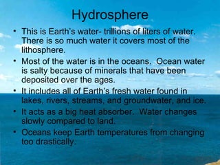
Rivers shape the land by eroding and depositing sediments over time. They cut valleys and canyons, form floodplains and deltas at their mouths. Running water is one of the most important forces changing Earth's surface. The land is made up of layers - the lithosphere is the outer rocky layer, the hydrosphere contains Earth's water, and the atmosphere is the blanket of gases. Together these systems continuously shape and resurface the planet.
2. Vocabulary
Runoff Precipitation that flows across the land’s surface or falls
into rivers and streams.
Watershed Area from which water is drained; region that
contributes water to a river or river system.
Sediment Pieces of material carried and deposited by water or
wind.
Meander Bends or s-shaped curves in a river.
Flood plain Land that is likely to be underwater during a flood.
Delta Fan-shaped region formed by deposits of sediments
found at the mouth of a river.
Lithosphere The hard outer layer of Earth, about 100 km thick.
Hydrosphere Earth’s water, found in continents and oceans,
including the fresh water in ice, lakes, rivers and
underground water.
atmosphere The blanket of gases that surrounds Earth.
3. How do rivers Change the Land?
• One of the most important causes of
change on Earth is running water.
• Rivers begin high in mountains or hills as
small tributaries.
• Runoff is water that runs off Earth’s solid
surface.
• An area from which water is drained is
called a wetland.
5. • The force of gravity
keeps water flowing
downhill.
• Pieces of material
carried by moving
water are called
sediment.
• The force of running
water with its load of
sediment can erode a
stream bed.
Yukon River
• Meanders are bends
or S-shapes in rivers.
6. • Some of the world’s most important
agriculture areas are found in flood
plains.
• Over time, sediments build up,
creating fertile farmlands.
7. • The place where a river empties into an
ocean is called the mouth of the river.
• The river slows down so much at its
mouth, that it unloads most of its sediment
there.
• A fan-shaped deposit of sediment is called
a delta.
8. How do Water Gaps, Canyons, and
Valleys form?
• Small channels that
are deepened and
widened by erosion
form river valleys.
• Small gullies become
deeper and wider as
their walls are eroded
and sediments are
carried away.
9. • Where downward cutting
is greater than valley
widening, narrow V-
shaped valleys form.
• Deep V-shaped valleys
are usually called
canyons.
• Usually more than one
process is involved in the
formation of canyons and
other landforms.
10. • The Grand Canyon would not exist if the
surrounding plateaus had not been
pushed upward as the Colorado River cut
deeper and deeper.
• Grand Canyon National Park - Fly-through
11. • Over time, a river that slowly cuts its way across
and down into resistant rock can form a water
gap.
• Water gaps are rare.
• It was formed by the river flowing over a
sediment-covered plain. As geological forces
pushed the land upward, the river began cutting
deeper into the plain.
• Eventually, much of the surrounding area eroded
away.
Delaware Water Gap
12. How do Beaches, Dunes, and
Landslides Form?
• Water, gravity, wind, waves and glaciers
are all agents of erosion.
• Beaches form when sediments are
deposited on shorelines.
• Waves can erode land along coast lines
or deposit sand and sediment forming
beaches.
13. • Dunes are created
when wind picks up
sand particles and
carries them until
obstacles, such as
sand and pieces of
shell, slow the wind
speed.
14. • Rapid landslides can
be set off by
earthquakes,
volcanic activity, and
heavy rains
•Gravity can pull rocks
and soil down slopes.
15. How do you read Topographic
Maps?
• Topographic maps use contour lines to
show the shape of Earth’s surface.
• A contour line is an imaginary line drawn
on a map. It connects points of equal
height above or below sea level.
• Sea level is the main level of the surface
of the sea between high and low tides. It
is considered as 0 elevation.
16. • Contour lines that are closer together
indicate a steeper slope.
• Contour lines that are farther apart
indicate a gentler slope.
• Bodies of water, such as oceans, rivers,
and lakes, are indicated on topographic
maps.
• Symbols are used to show buildings,
roads, forests, and railroad tracks.
17. Look at page C24-C25
• Read the pages. Write about what you
notice on the topographic map, and the
relief map.
• What is the difference between the two
maps?
• Are there any similarities?
18. What are Earth’s Major Layers?
• Earth has a solid
surface layer, mostly
covered by a layer of
water, and
surrounded by a layer
of gases.
19. The Lithosphere
• The hard outer layer of
Earth is the lithosphere.
• The rocky surface that
makes up the top of the
lithosphere is the crust.
• The crust is thinnest
under oceans, and
thickest at continents.
• The crust includes the
soil and many other
resources; such as
minerals that help support
life on Earth.
20. Hydrosphere
• This is Earth’s water- trillions of liters of water.
There is so much water it covers most of the
lithosphere.
• Most of the water is in the oceans. Ocean water
is salty because of minerals that have been
deposited over the ages.
• It includes all of Earth’s fresh water found in
lakes, rivers, streams, and groundwater, and ice.
• It acts as a big heat absorber. Water changes
slowly compared to land.
• Oceans keep Earth temperatures from changing
too drastically.
21. Atmosphere
• Layers of gases that
surround Earth.
• There are 4 major layers
of the atmosphere.
• The troposphere-is
closest to Earth, it
contains oxygen needed
for living things, and is
where almost all of
Earth’s weather occurs.
• The other layers of the
atmosphere help protect
Earth against harmful
energy from the sun.
22. Why it matters?
• The Earth changes, renews, and recycles itself
through natural processes.
• Running water and the sediments it carries are
vital to the environment and the quality of our
lives.
• The constant cycling of water and sediments
provides fresh water and fertile soils.
• Before we remove vegetation, build dams, or re-
channel streams and rivers, we must consider
the short-term benefits and the long term effects
on Earth.