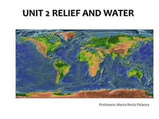
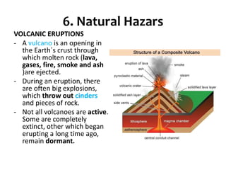
UNIT 2 RELIEF AND WATER
Profesora: Marta Recio Palanca
• 1. The Earth´s estructure
• 2. The Earth´s surface: tectonic plates
• 3. Changes in relief: internal and external
forces
• 4. Land relief: continental relief and
continental waters
• 5. Coastal relief and the oceanic relief
• 6. Natural hazars
1. The Earth´s structure
The Earth´s structure clip
https://www.youtube.com/watch?v=eXiVGEEPQ6c
2. The Earth´s surface: Tectonic Plates
The Litosphere is composed of the crust and the upper mantle, but you have
to take into account that there are part of the crust that is in the oceans…
• The Litosphere is composed of the crust and the upper mantle, but you
have to take into account that there are part of the crust that is in the
oceans…
The litosphere also is divided into large blocks of
rocks called plates.
How it occur?
Tectonic Plates for kids https://www.youtube.com/watch?v=kwfNGatxUJI
https://www.youtube.com/watch?v=_kF-IKbavDA
https://www.youtube.com/watch?v=tcPghqnnTVk OK
Wegener theory https://www.youtube.com/watch?v=zbtAXW-2nz0
So… a little summary
When we have plates movements, we
have earthquakes in the crust.
3. CHANGES IN RELIEF: INTERNAL AND
EXTERNAL FORCES
External forces:
Water dissolves limestones
Water excavates deep valleys and canyons
https://www.youtube.com/watch?v=-
llj13tENkc
Ruta del Cares a vista de dron
Rivers tear away/carries materials
Water infiltrates through the crevices
Water freezes and breaks the rocks
Wind erodes rocks
Wind shapes rocks
Wind transports/sediments rocks
4-5. Types of relief: continental, coastal and oceanic
Continental Relief
Continental relief: Mountains
Are high landforms with
steep sides.
The world´s highest
mountain range is the
Himalaya in Asia.
Continental
relief: valleys
Areas of loud land
between mountains.
Rivers flow through many
valleys.
Continental Relief:
plateaus
Are large, raised
plaisn. The highest
plateaus are in Tibet
in Asia, and in Bolivia
in South America.
Continental Relief:
plains
Are low, flat areas of
land. Large plains are
often found on the
coast, and are formed
by large rivers.
What is the
difference between a
plateau and a plain?
Coastal Relief
Coastal relief: gulfs and capes
Cape or headland is a part of
the coast that extends to the
sea.
Gulf is a large part of the
ocean or the sea partially
enclosed by land. A bay is a
small gulf.
Coastal relief: cliffs
Are steep rock formations
in high coastal areas
Coastal relief: islands
Are areas of land
surronded by water on all
sides. A group of islands is
called archipelago.
Coastal relief: lagoon (albufera)
Small lake separated to
the se by a bar of sand
Is there any lagoon in
Spain?
Oceanic relief
WATER ON EARTH
RIVERS: a natural stream of water of
usually considerable volume
The upper-course of a river
V-shaped Valley - a valley
which resembles a 'v' in cross
section. These valleys have
steep sloping sides and
narrow bottoms.
Waterfall - Waterfalls usually
occur where a band of hard
rock lies next to soft rock.
They end up creating steep
sided valleys known as gorges
or canyons.
The middle-course of a river
• Here the river channel has
become much wider and deeper
as the channel has been eroded
and the river has been fed by
many tributaries upstream.
• •As well as changes in the river
channel, its surrounding valley
has also become wider and
flatter in cross-section with a
more extensive floodplain.
• •Unlike the relatively straight
channel of the upper course, in
the middle course there are many
meanders (bends) in the river.
The lower course of a river
As a river continues its journey
towards the sea, the valley cross
section continues to become
wider and flatter with an
extensive floodplain either side
of the channel.
When the river floods over the
surrounding land it loses energy
and deposition of its suspended
load occurs. Regular flooding
results in the building up of layers
of nutrient rich alluvium which
forms a flat and fertile floodplain
Features in the mouth of a river
Deltas are found at the mouth of
large rivers - for example, the Nile,
Ebrus or Mississippi. A delta is
formed when the river deposits its
material faster than the sea can
remove it.
Estuary: A partially enclosed
body of water along the coast where
freshwater from rivers and streams
meets and mixes with salt water
from the ocean.
WHAT ARE THE LONGEST RIVER
IN THE WORLD?
LAKES: are permanent masses of water which have
accumulated inland
When they are small they
are called ponds. If their
water is salt water they
are called inland seas
(Caspian Sea)
The water in lakes has
different origins:
•Precipitation
•Rivers and groundwater
•Glaciers
Groundwater
Runs and is stored under the ground.
It represents 25% of the water on
the continents.
Most groundwater comes from
precipitation. When it rains, some
water penetrates the ground and
filters through porous rocks. When it
reaches permeable rocks, it cannot
pass through and forms aquifers and
underground rivers and lakes.
In limestone areas, water dissolves
the rock and creates caves and
caverns with stalactites and
stalagmites
Glaciers: are large, slow moving, masses of ice, that
deform and move downslope under their own weight. They
may be considered “rivers of ice”
Approximately 10% of the
earth's surface is covered
by glaciers. Large areas of
glacial ice are found in high
latitude areas such as
Greenland and Antarctica,
however glaciers are also
found in areas of high
altitude
(e.g. the Rockies, Alps,
Himalaya).
But we can find rest of
glaciers in Spain too.
Ordesa y Monteperdido.
Huesca. P.N. Pirineos
• Lagos de Sanabria y
• Covadonga.
6. Natural Hazars
VOLCANIC ERUPTIONS
- A vulcano is an opening in
the Earth´s crust through
which molten rock (lava,
gases, fire, smoke and ash
)are ejected.
- During an eruption, there
are often big explosions,
which throw out cinders
and pieces of rock.
- Not all volcanoes are active.
Some are completely
extinct, other which began
erupting a long time ago,
remain dormant.
EARTHQUAKES
Are tremors or shaking in
the Earth´s crust that can
cause fisures and
movements on the Earth´s
surface. The strenght of the
tremors is called magnitud.
We measured the magnitude
with an instrument called
seismograph and we creates
scales with the information
obtained. One of the best-
known scales is the Richter
scale.
TSUNAMIS: Is an
earthquake caused in the
sea, it´s epicentre was in
the sea, and the seismic
waves cause enormus
waves in the water.
https://www.youtube.com/wat
ch?v=PkIM7uwJ3Eg
• EARTHQUAKES FOR
KIDS
• VOLCANOES FOR KIDS
• TSUNAMIS FOR KIDS
VOCABULARY YOU SHOULD KNOW
FOR THE EXAM
- Crust
- Mantle
- Core
- Litosphere
- Plates
- Mountains
- Valleys
- Plains
- Plateaus
- Glacier
- Groundwater
- Lake
- MeandersEstuary
- Delta
- Limestone
- Cliff
- Bay
- Gulf
- Cape
- Island/archipelago
- Continental shelf (plataforma)
- Continental slope (talud)
- Abysal plain
- Ocean ridge (dorsal)
- Ocean trench (fosa)
- Volcano
- Cinder
- Crater
- Volcanic cone
- Vent
- Magma
- Seismograph
- Epicentre
- Focus (hipocentro)
- Tsunami

Unit 2 relief

  • 1.
    UNIT 2 RELIEFAND WATER Profesora: Marta Recio Palanca
  • 2.
    • 1. TheEarth´s estructure • 2. The Earth´s surface: tectonic plates • 3. Changes in relief: internal and external forces • 4. Land relief: continental relief and continental waters • 5. Coastal relief and the oceanic relief • 6. Natural hazars
  • 3.
    1. The Earth´sstructure
  • 4.
    The Earth´s structureclip https://www.youtube.com/watch?v=eXiVGEEPQ6c
  • 6.
    2. The Earth´ssurface: Tectonic Plates The Litosphere is composed of the crust and the upper mantle, but you have to take into account that there are part of the crust that is in the oceans…
  • 7.
    • The Litosphereis composed of the crust and the upper mantle, but you have to take into account that there are part of the crust that is in the oceans…
  • 8.
    The litosphere alsois divided into large blocks of rocks called plates.
  • 11.
    How it occur? TectonicPlates for kids https://www.youtube.com/watch?v=kwfNGatxUJI https://www.youtube.com/watch?v=_kF-IKbavDA https://www.youtube.com/watch?v=tcPghqnnTVk OK Wegener theory https://www.youtube.com/watch?v=zbtAXW-2nz0
  • 12.
  • 14.
    When we haveplates movements, we have earthquakes in the crust.
  • 15.
    3. CHANGES INRELIEF: INTERNAL AND EXTERNAL FORCES
  • 16.
  • 17.
  • 18.
    Water excavates deepvalleys and canyons https://www.youtube.com/watch?v=- llj13tENkc Ruta del Cares a vista de dron
  • 19.
  • 20.
  • 21.
    Water freezes andbreaks the rocks
  • 22.
  • 23.
  • 24.
  • 25.
    4-5. Types ofrelief: continental, coastal and oceanic
  • 26.
  • 27.
    Continental relief: Mountains Arehigh landforms with steep sides. The world´s highest mountain range is the Himalaya in Asia.
  • 28.
    Continental relief: valleys Areas ofloud land between mountains. Rivers flow through many valleys.
  • 29.
    Continental Relief: plateaus Are large,raised plaisn. The highest plateaus are in Tibet in Asia, and in Bolivia in South America.
  • 30.
    Continental Relief: plains Are low,flat areas of land. Large plains are often found on the coast, and are formed by large rivers. What is the difference between a plateau and a plain?
  • 31.
  • 32.
    Coastal relief: gulfsand capes Cape or headland is a part of the coast that extends to the sea. Gulf is a large part of the ocean or the sea partially enclosed by land. A bay is a small gulf.
  • 33.
    Coastal relief: cliffs Aresteep rock formations in high coastal areas
  • 34.
    Coastal relief: islands Areareas of land surronded by water on all sides. A group of islands is called archipelago.
  • 35.
    Coastal relief: lagoon(albufera) Small lake separated to the se by a bar of sand Is there any lagoon in Spain?
  • 36.
  • 38.
  • 39.
    RIVERS: a naturalstream of water of usually considerable volume
  • 41.
    The upper-course ofa river V-shaped Valley - a valley which resembles a 'v' in cross section. These valleys have steep sloping sides and narrow bottoms. Waterfall - Waterfalls usually occur where a band of hard rock lies next to soft rock. They end up creating steep sided valleys known as gorges or canyons.
  • 42.
    The middle-course ofa river • Here the river channel has become much wider and deeper as the channel has been eroded and the river has been fed by many tributaries upstream. • •As well as changes in the river channel, its surrounding valley has also become wider and flatter in cross-section with a more extensive floodplain. • •Unlike the relatively straight channel of the upper course, in the middle course there are many meanders (bends) in the river.
  • 43.
    The lower courseof a river As a river continues its journey towards the sea, the valley cross section continues to become wider and flatter with an extensive floodplain either side of the channel. When the river floods over the surrounding land it loses energy and deposition of its suspended load occurs. Regular flooding results in the building up of layers of nutrient rich alluvium which forms a flat and fertile floodplain
  • 44.
    Features in themouth of a river Deltas are found at the mouth of large rivers - for example, the Nile, Ebrus or Mississippi. A delta is formed when the river deposits its material faster than the sea can remove it. Estuary: A partially enclosed body of water along the coast where freshwater from rivers and streams meets and mixes with salt water from the ocean.
  • 45.
    WHAT ARE THELONGEST RIVER IN THE WORLD?
  • 47.
    LAKES: are permanentmasses of water which have accumulated inland When they are small they are called ponds. If their water is salt water they are called inland seas (Caspian Sea) The water in lakes has different origins: •Precipitation •Rivers and groundwater •Glaciers
  • 49.
    Groundwater Runs and isstored under the ground. It represents 25% of the water on the continents. Most groundwater comes from precipitation. When it rains, some water penetrates the ground and filters through porous rocks. When it reaches permeable rocks, it cannot pass through and forms aquifers and underground rivers and lakes. In limestone areas, water dissolves the rock and creates caves and caverns with stalactites and stalagmites
  • 50.
    Glaciers: are large,slow moving, masses of ice, that deform and move downslope under their own weight. They may be considered “rivers of ice” Approximately 10% of the earth's surface is covered by glaciers. Large areas of glacial ice are found in high latitude areas such as Greenland and Antarctica, however glaciers are also found in areas of high altitude (e.g. the Rockies, Alps, Himalaya). But we can find rest of glaciers in Spain too.
  • 51.
  • 52.
    • Lagos deSanabria y • Covadonga.
  • 53.
    6. Natural Hazars VOLCANICERUPTIONS - A vulcano is an opening in the Earth´s crust through which molten rock (lava, gases, fire, smoke and ash )are ejected. - During an eruption, there are often big explosions, which throw out cinders and pieces of rock. - Not all volcanoes are active. Some are completely extinct, other which began erupting a long time ago, remain dormant.
  • 55.
    EARTHQUAKES Are tremors orshaking in the Earth´s crust that can cause fisures and movements on the Earth´s surface. The strenght of the tremors is called magnitud. We measured the magnitude with an instrument called seismograph and we creates scales with the information obtained. One of the best- known scales is the Richter scale.
  • 57.
    TSUNAMIS: Is an earthquakecaused in the sea, it´s epicentre was in the sea, and the seismic waves cause enormus waves in the water. https://www.youtube.com/wat ch?v=PkIM7uwJ3Eg
  • 58.
    • EARTHQUAKES FOR KIDS •VOLCANOES FOR KIDS • TSUNAMIS FOR KIDS
  • 59.
    VOCABULARY YOU SHOULDKNOW FOR THE EXAM - Crust - Mantle - Core - Litosphere - Plates - Mountains - Valleys - Plains - Plateaus - Glacier - Groundwater - Lake - MeandersEstuary - Delta - Limestone - Cliff - Bay - Gulf - Cape - Island/archipelago - Continental shelf (plataforma) - Continental slope (talud) - Abysal plain - Ocean ridge (dorsal) - Ocean trench (fosa) - Volcano - Cinder - Crater - Volcanic cone - Vent - Magma - Seismograph - Epicentre - Focus (hipocentro) - Tsunami